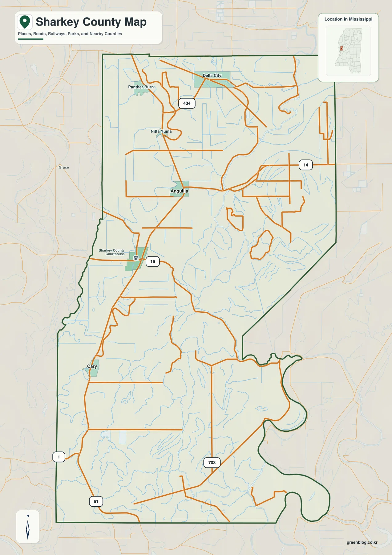
Sharkey County map files are available to download directly from this page. The supplied maps show Rolling Fork, Anguilla, Cary, Delta City, Panther Burn, the principal road references, the water network, and elevation across a very low Mississippi Delta landscape. Big Sunflower River, Little Sunflower River, Rolling Fork Creek, Deer Creek, False River, and several bayous provide better physical reference points here than mountains or major ridges would. The download ZIP contains the county, city, water, and elevation maps as high-resolution A3 JPG files.
Sharkey County is easiest to understand as a low floodplain county shaped by roads and wandering waterways. Rolling Fork sits slightly west of the county’s middle, Anguilla is to the north, and Cary is farther south. The eastern and southern portions contain increasingly dense drainage lines, and the elevation map shows only a modest difference between the lowest and highest ground. In a landscape where the actual elevation range is about 21 to 38 meters, subtle river-related relief matters much more than a traditional mountain-and-valley description.
Table of Contents
Quick Facts
Rolling Fork is the county seat. The Census figures supplied in the package list 3,800 residents in the 2020 census and a July 2025 estimate of 3,097. Those numbers use different reference dates and methods, so they are best treated as separate benchmarks rather than identical measurements taken several years apart. The supplied 2025 Gazetteer values list 431.720 square miles of land and 3.400 square miles of water.
Using the 2020 population and the supplied land area gives roughly 8.8 residents per square mile. That is a countywide average, not a picture of people being evenly spread across every field, forest tract, bayou, and road. Settlement is more concentrated around places such as Rolling Fork and Anguilla and along the main road corridors, while large parts of the county are agricultural, wooded, wet, or sparsely settled.
Selected labels visible in the package include Rolling Fork, Anguilla, Cary, Delta City, Panther Burn, and Nitta Yuma. The existing article identifies US 61, MS 14, MS 16, and MS 1 as primary route references, and the supplied county map also labels MS 434 and MS 703. Sharkey County’s FIPS code is 28125. These details establish the county’s basic identity without replacing a current navigation or parcel source.
Reading the Sharkey County Mississippi map
Rolling Fork is the best place to begin on the general county map. US 61 runs through the western side of the county and provides a strong north-south reference between Anguilla, Rolling Fork, and the Cary direction. MS 16 is labeled near Rolling Fork, MS 14 appears in the northeastern half, MS 434 crosses the north, and MS 703 is marked farther south. Delta City, Panther Burn, and Nitta Yuma add useful reference points across the northern farm country.
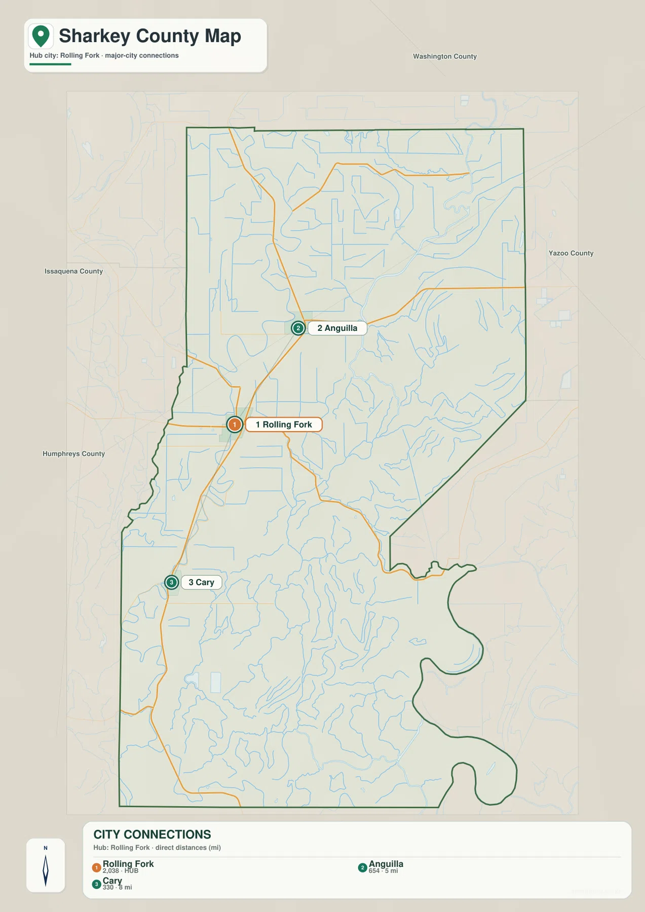
The county outline is not a simple rectangle. A broad northern block narrows through the west-central section before extending into a long southern area, and the southeastern boundary contains several large curves. Washington, Yazoo, Humphreys, and Issaquena counties appear around the outside of the city-connections map and make regional direction easier to understand. Those neighboring labels are especially useful because settlement within Sharkey County is relatively sparse.
The city-connections map simplifies the county to three selected communities. Rolling Fork is the hub, Anguilla is about 5 miles away by straight-line distance, and Cary is about 8 miles away. These are direct point-to-point distances printed on the graphic, not driving mileage. The same map lists Rolling Fork at 2,038 residents, Anguilla at 654, and Cary at 330, which helps compare the relative size of the three selected places without treating them as the entire county population.
Boundary, Water, and Terrain
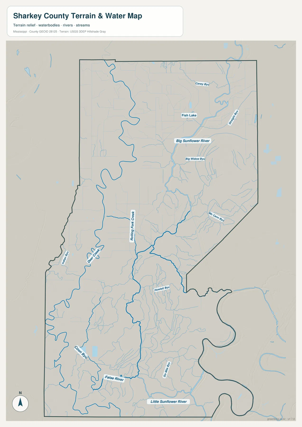
The water map is dominated by Big Sunflower River, which runs through the eastern half before continuing south. Little Sunflower River is labeled near the southern edge, while Rolling Fork Creek descends through the west-central interior and connects into the broader drainage network. Deer Creek lies farther west. In the northeast, Caney Bayou and Straight Bayou are labeled, and Big Widow Bayou and McCrann Bayou appear farther south.
The southern half becomes increasingly intricate. False River, Coolin Bayou, Sharkey Bayou, and Howlett Bayou are named among many smaller channels, and Fish Lake is visible in the north. This pattern is characteristic of the supplied map’s Delta setting: the landscape contains broad meanders, abandoned-looking channels, and many narrow drainage lines rather than one steep river descending through a confined valley.
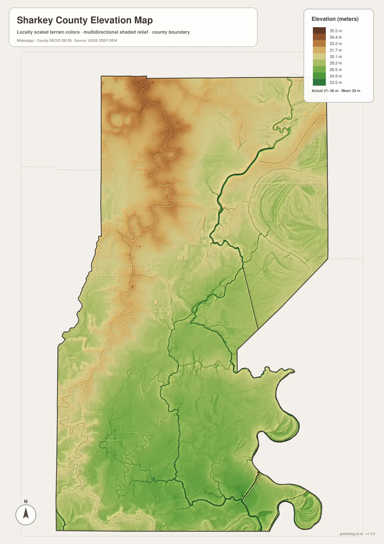
The elevation map prints an actual range of about 21 to 38 meters and a mean of 29 meters. Slightly higher tan and brown ground is more visible in the northwest, while broad green lowlands dominate much of the center and south. These are subtle differences, not mountain relief. Curved bands and crescent-shaped features around waterways also appear on the elevation surface, making old or shifted channels easier to recognize.
In a county this flat, a few meters of vertical difference can still help explain where river corridors, low swales, and slightly higher ground occur. The elevation map is generalized for county-scale comparison and should not be used as survey data for farms, buildings, levees, drainage design, or flood-risk decisions. Its best use here is showing how little the county rises overall and how closely the small variations follow the water network.
Settlement and Regional Context
The supplied existing article describes Rolling Fork as the county seat and service center. The city map also gives it the strongest emphasis, with Anguilla to the north and Cary to the south along the broader US 61 corridor. Delta City, Panther Burn, and Nitta Yuma show a different side of the county: small named places scattered through broad farm country rather than one continuous urban area.
Delta National Forest is another landscape reference included in the supplied article and official-link catalog. The name does not mean the entire Mississippi Delta. It refers to a specific federally managed forest area associated with floodplain forest and wetland habitat. The maps on this page are not legal forest-ownership maps, so exact management boundaries should be checked with the U.S. Forest Service source rather than inferred from the general county graphic.
The existing source material also notes that Rolling Fork suffered major tornado damage in 2023. That fact is useful regional context, but the supplied maps are not damage-assessment or recovery-status maps. They show the enduring geographic framework—settlements, roads, waterways, and terrain. Anyone needing current building conditions or recovery information should use an up-to-date local or emergency-management source.
Practical Map Uses
Use the general county map when the county edge, principal routes, and several place names need to appear together. The city-connections map is better when the main question is how Rolling Fork relates to Anguilla and Cary and when the printed straight-line distances are useful. Choose the water map for Big Sunflower River, Rolling Fork Creek, Deer Creek, the bayous, and the small lakes. The elevation map adds the physical context by showing just how low and flat the landscape is.
For a classroom or presentation, the water and elevation maps make a strong pair. One identifies the present waterways and named channels; the other reveals the subtle low corridors and curved landforms around them. For transportation and settlement, the general map and city-connections view work better together. The A3 JPG originals in the download archive are larger than the WebP previews used on the page and are more suitable for printing or editing.
Frequently Asked Questions
Does Delta National Forest mean the entire Mississippi Delta?
No. It is a specific federally managed forest containing floodplain habitat. It should be distinguished from the much broader regional term Mississippi Delta.
How can Delta National Forest clarify the part of Sharkey County facing Washington?
Looking only at Rolling Fork would reduce the map to town labels, whereas Delta National Forest explains the landscape transition toward Washington.
Map File Information
The ZIP contains the Sharkey County county, city, water, and elevation maps as high-resolution A3 JPG files. These originals are larger than the WebP page previews and can be used for printing, editing, classroom materials, or location-reference graphics.
- File Type: four high-resolution JPG files in one ZIP
Related Maps
Sources
- U.S. Census Bureau QuickFacts for Sharkey County — population reference
- U.S. Census Bureau Gazetteer Files — land and water area reference
- Mississippi Department of Transportation Official Highway Map — principal route reference
- U.S. Forest Service Delta Ranger District — Delta National Forest regional reference
- USGS National Hydrography — rivers, creeks, bayous, and waterbody reference
- USGS 3D Elevation Program — elevation and terrain reference
Green Map creates custom-edited map images using open geographic data sources such as geoBoundaries, Natural Earth, OpenStreetMap, and government open data. These maps are edited visual materials, not raw data files, and are provided for education, documents, presentations, and graphic reference.