Quitman County, Mississippi, can be understood quickly from Marks, the Coldwater River, and the flat Delta landscape around them. Marks sits near the county’s central road network, Lambert lies a short distance to the south, and Crowder, Sledge, and Falcon provide useful references farther out. The supplied maps also show how the Coldwater River winds through the county before the drainage network reaches the Tallahatchie River system in the southeast. You can download the county, city, water, and elevation maps on this page as high-resolution A3 JPG files in one ZIP archive.
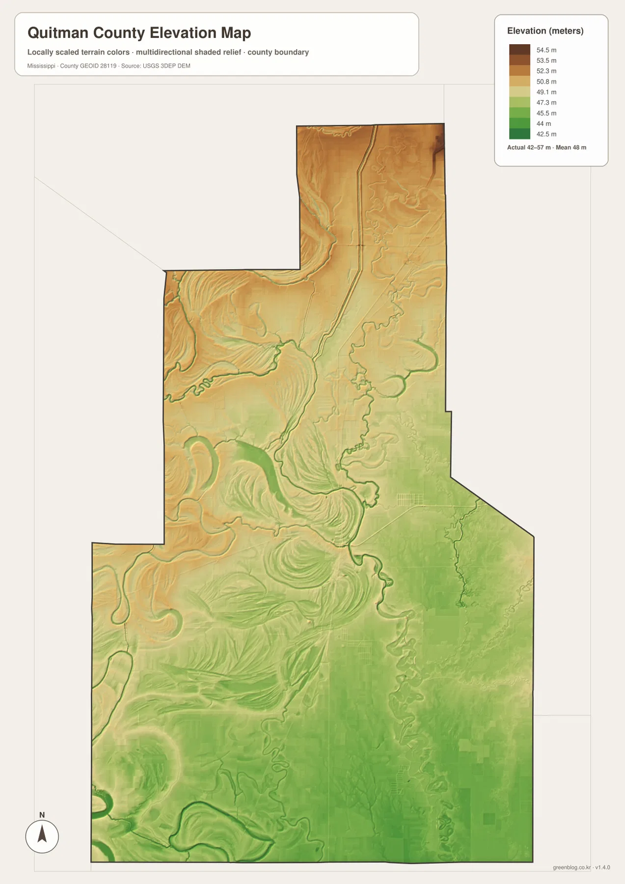
The county is part of the Mississippi Delta, so the most useful geographic cues are different from those in a mountain or plateau county. There are no major ridges dominating the map. Instead, roads cross broad low farmland, rivers make long bends, and small lakes and former channels appear beside the main waterways. The elevation surface reinforces that impression: the printed actual range is only about 42 to 57 meters, with a mean of 48 meters. That small range makes river bends, low swales, and old channels much more important for reading the landscape.
Table of Contents
Marks and the main roads across an irregular county outline
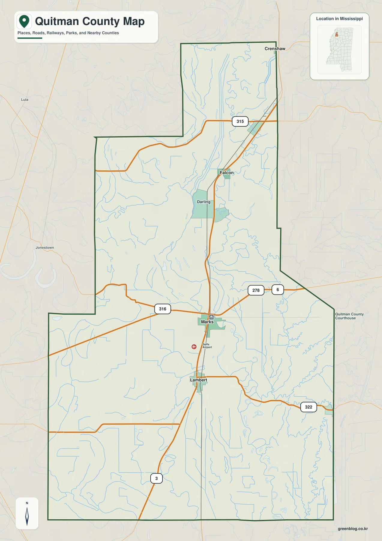
Marks is the most practical starting point on the general county map. US 278 and MS 6 run east-west through the Marks area, while MS 3 provides the main north-south reference through Lambert and toward Falcon. MS 316 reaches west from the Marks area, MS 322 continues east from the southern half, and MS 315 crosses the northern section near Sledge. With those routes in place, the positions of the smaller communities become much easier to follow.
The county boundary is noticeably irregular. The north is a narrower projection, the middle widens toward the west, and the southern half opens into a larger block. Sledge and Falcon sit in the northern portion, Marks occupies the central-southern road junction, and Lambert lies below it. Crowder is farther southeast. This shape is one reason straight-line distances between communities can be useful even when the road network appears simple.
The surrounding county labels help with wider orientation. Tunica County is north of Quitman County, Panola County lies to the east, Coahoma County is to the west, and Tallahatchie County is to the south. The map also marks the Quitman County Courthouse and Selfs Airport near Marks. Those details make the general map useful as an overview: it combines settlement labels, principal highways, water features, and the county edge without trying to show every farm road or drainage ditch.
City connections from Marks to Lambert, Crowder, Sledge, and Falcon
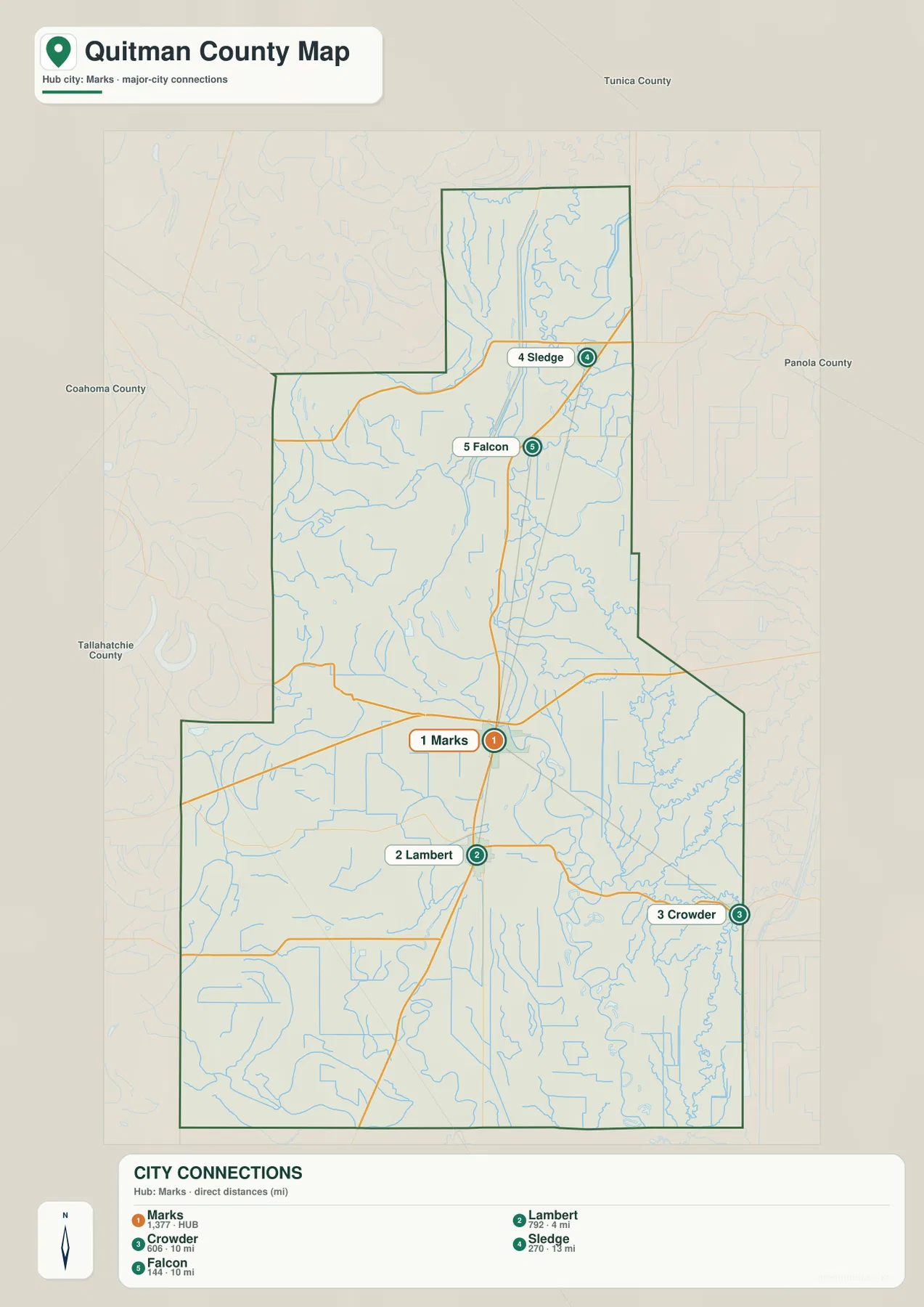
The city-connections map removes much of the background detail and treats Marks as the hub. Lambert is shown about 4 miles south of Marks by straight-line distance. Crowder is about 10 miles to the southeast, Falcon about 10 miles to the north, and Sledge about 13 miles to the north-northeast. These are direct point-to-point distances printed on the map, not driving distances, so they should not be used as road-mileage estimates.
The map also ranks the selected communities by the population figures shown in its index. Marks is listed at 1,377, Lambert at 792, Crowder at 606, Sledge at 270, and Falcon at 144. The purpose of those numbers here is comparative. They make it clear why Marks receives the strongest visual emphasis while the other places act as smaller geographic anchors around the county. They should not be confused with the total population of Quitman County.
Other names, including Crenshaw and Darling, appear on the general county map but are not part of the five-place city ranking. That difference is useful rather than contradictory. The general map is better for a broad inventory of places and roads, while the city-connections map is designed to answer a narrower question: where are the selected communities in relation to Marks, and how far apart are they in a straight line?
Coldwater River bends, old channels, bayous, and small lakes
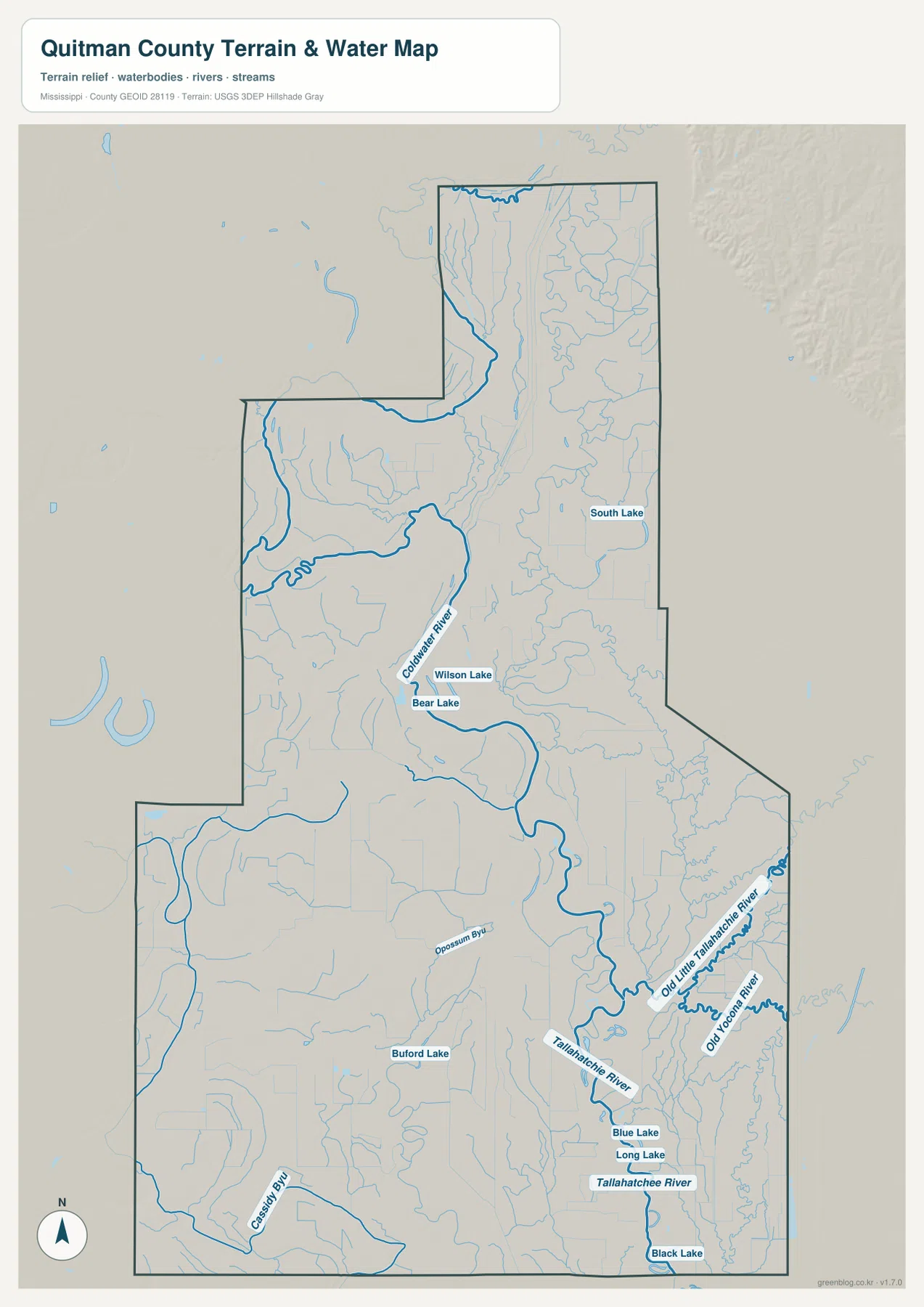
The water map is dominated by the Coldwater River. It enters the northern part of the county, swings across the middle, and forms broad curves before continuing toward the southern drainage system. Its shape is very different from a steep upland stream. Long meanders and abandoned-looking bends fit the low-gradient Delta setting, where a river can migrate across a wide floodplain over time.
The southeastern part of the map becomes even more intricate. Tallahatchie River is labeled near the lower-right side, along with Old Little Tallahatchie River and Old Yocona River. Those names make the history of shifting channels visible on the map. Opossum Bayou crosses the south-central area, while Cassidy Bayou appears farther southwest. Together, these features show why a simple road map does not fully explain the county: much of the local landscape has been shaped by river movement and drainage across a very flat plain.
Several small lakes are labeled beside the waterways. Wilson Lake and Bear Lake sit close to the Coldwater River. South Lake is farther east, and Buford Lake lies in the southwestern half. Near the Tallahatchie system, Blue Lake and Long Lake appear close together, with Black Lake farther south. Rather than one dominant reservoir, Quitman County has a scattered pattern of small water bodies associated with the broader Delta drainage landscape.
This map should be used as a location and landscape reference. It is not a flood-insurance map, parcel survey, legal water-boundary map, levee-safety assessment, or navigation chart. For those purposes, a specialized current source is required. Here, the main value is seeing how the Coldwater River, Tallahatchie system, bayous, and small lakes fit around Marks and the rest of the county.
A 42–57 meter elevation range across the Delta plain
The elevation map prints an actual county range of about 42 to 57 meters and a mean of 48 meters. That is a small vertical difference over a county-sized area, which confirms how flat the Delta landscape is. Tan and brown areas are somewhat more common in the north and northwest, while greener low ground spreads across much of the south and southeast. The change is subtle, not mountainous.
The most revealing features are the curved bands around river corridors. Meander scars and low swales produce crescent and looping shapes that resemble the bends on the water map. When the two maps are compared, the relationship becomes clear: even a few meters of relief can separate slightly higher ground from old channels and low river-adjacent terrain. In a county this flat, those small differences matter more for understanding the visible landform pattern than a traditional ridge-and-valley description would.
The elevation surface is generalized for county-scale viewing. It is not survey-grade data for determining the exact height of a farm, building site, levee, road grade, or drainage project. It also should not be treated as a flood-risk map. Its best use is comparative: it shows just how little the county rises and falls overall and where lower river-related corridors stand out against slightly higher parts of the plain.
Population and area put the mapped landscape in perspective
The supplied Census references list 6,176 residents in the 2020 census and a July 2025 estimate of 5,364. Those figures refer to different dates and measurement methods, so they are best treated as separate benchmarks. They do, however, show that Quitman County has a relatively small population spread across a large rural landscape. Marks is the county seat and the largest of the selected places on the city map, but much of the county consists of farmland, drainage corridors, and open rural space between settlements.
The supplied 2025 Gazetteer values list 405.012 square miles of land and 1.419 square miles of water. That may seem surprising on a map with so many blue lines, but most of those features are narrow rivers, creeks, bayous, ditches, or small lakes rather than broad open-water areas. Using the 2020 population and the listed land area gives roughly 15.2 residents per square mile, but that is only a countywide average. People are not evenly spread across every field, river bend, and drainage tract.
Choosing between the road, city, water, and elevation views
Choose the general county map when the county boundary, major highways, and several place names need to appear together. Use the city-connections map when the main question is how Marks relates to Lambert, Crowder, Sledge, and Falcon, especially when the printed straight-line distances are useful. The water map is the strongest choice for Coldwater River, Tallahatchie River, bayous, old channels, and the named lakes. The elevation map adds context by showing that all of those features sit within a very low 42–57 meter landscape.
For teaching or a presentation, the water and elevation maps work particularly well as a pair. One shows the present and former water features; the other shows the subtle relief around them. If the focus is transportation and settlement, the general county map and the city-connections map make a better pair. The high-resolution files in the download archive preserve the same four map subjects at a larger size than the WebP previews used on the page.
Frequently Asked Questions
Does passenger rail stop at Marks?
Yes. The supplied reference links include the Amtrak station page for Marks. That adds another transportation reference to the road-centered map, although current train times and service details should always be checked against the latest Amtrak schedule.
Does Quitman County directly border the Mississippi River?
No Mississippi River segment appears along the county boundary on the supplied maps. Coahoma County lies to the west, while the major water references inside Quitman County are the Coldwater River and the Tallahatchie River system in the southeast.
Why is an elevation map useful when the county is so flat?
The actual range is only about 42 to 57 meters, but in a Delta county even small elevation differences help reveal old channels, low swales, and river-adjacent terrain. Comparing the elevation map with the water map makes the meander-shaped landforms around the Coldwater and Tallahatchie systems easier to understand.
Map File Information
The ZIP contains the Quitman County county, city, water, and elevation maps as high-resolution A3 JPG files. These originals are larger than the WebP page previews and can be used for printing, editing, classroom materials, or location-reference graphics.
- File Type: four high-resolution JPG files in one ZIP
Related Maps
Sources and References
- U.S. Census Bureau QuickFacts for Quitman County — population reference
- U.S. Census Bureau Gazetteer Files — land and water area reference
- Mississippi Department of Transportation Official Highway Map — major route reference
- USGS National Hydrography — rivers, bayous, and waterbody reference
- USGS 3D Elevation Program — elevation and terrain reference
- Amtrak Marks Station — passenger rail reference
Green Map creates custom-edited map images using open geographic data sources such as geoBoundaries, Natural Earth, OpenStreetMap, and government open data. These maps are edited visual materials, not raw data files, and are provided for education, documents, presentations, and graphic reference.