Prentiss County in northeastern Mississippi is centered on Booneville, with smaller communities and road junctions spread toward Jumpertown, New Site, Marietta, Wheeler, and Baldwyn. The county map makes US 45 and MS 145 easy to follow on the western side of Booneville, while state routes extend east and west across a landscape cut by many creeks. This page combines the road-and-boundary view with a city-connections map, a detailed water map, and an elevation map. You can download all four supplied maps as high-resolution A3 JPG files in one ZIP archive for printing, editing, classroom use, or location-reference graphics.
The most distinctive feature is not a single large lake or one broad flat plain. Prentiss County is broken into repeated ridges and stream valleys. On the elevation map, high ground is especially prominent across the north and northeast, while lower green corridors widen through the center and south. The water map fills those low areas with named creeks and branching tributaries, including Tuscumbia River, Martin Creek, Camp Branch, and Hurricane Creek. Reading those layers together shows why Booneville works well as a central reference point and why communities only a few miles apart can sit on different sides of a ridge or drainage valley.
Table of Contents
Booneville as the center of the county road network
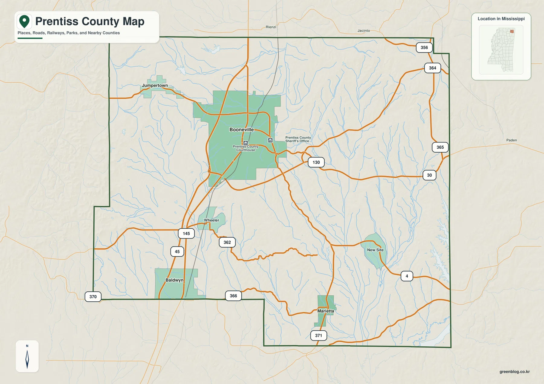
The general county map is the best place to begin because it shows settlements, highways, county edges, and numerous small waterways on the same page. Booneville occupies the central-northern part of the county. US 45 and MS 145 run north-south just west of the city and continue toward Wheeler and Baldwyn to the south. MS 30 leaves the Booneville area toward the east, and MS 130 is also labeled on the east side of the city. Farther southeast, New Site sits near MS 4, while Marietta marks the southern extension where MS 371 reaches the county.
Other route numbers help define the outer parts of the county. MS 356 and MS 364 appear near the northeastern edge, MS 365 runs along the east side, and MS 366 and MS 370 are visible near the southwestern edge around Baldwyn. Jumpertown provides a clear northwestern reference point. The map does not attempt to label every local rural road, so it is best for understanding direction and regional connections rather than turn-by-turn navigation. Current road closures, bridge conditions, and private-road access still require a live transportation source.
Jumpertown and Marietta measured from Booneville
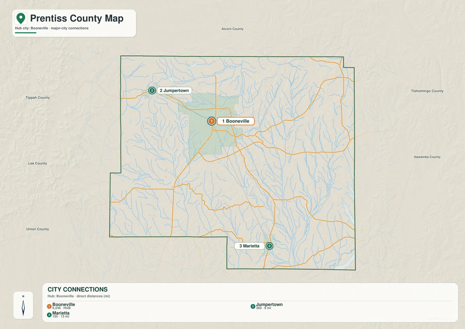
The city-connections map strips away much of the road detail and compares three selected communities. Booneville is the hub. Jumpertown lies northwest of it, while Marietta is southeast near the lower county boundary. The map labels the direct distance from Booneville to Jumpertown as about 6 miles and the direct distance from Booneville to Marietta as about 13 miles. Those are straight-line distances between mapped points, not driving distances along the road network, so they should not be used to estimate travel time without a current routing map.
The same city map includes a simple population ranking for the three selected places: Booneville is shown at 9,246 residents, Jumpertown at 360, and Marietta at 195. The numbers are useful for understanding the relative scale of the labeled communities, but they are not a countywide population table. Booneville clearly dominates the comparison, while Jumpertown and Marietta work mainly as geographic reference points on opposite sides of the county. Baldwyn is visible on the general county map but is not one of the three communities highlighted in this connections panel.
Where Prentiss County sits among neighboring counties
The city-connections map also provides a useful regional frame outside the county boundary. Alcorn County is labeled to the north. Tippah County and Lee County appear to the west, with Union County farther toward the southwest side. Tishomingo County and Itawamba County are labeled to the east. Those names make it easier to understand the direction of routes leaving Booneville and to place Prentiss County within the broader northeastern Mississippi county pattern.
Baldwyn deserves extra attention when reading the southwestern edge. The supplied current article notes that Baldwyn extends across the Prentiss-Lee county line, and the general map places the city label close to that boundary. A municipal name therefore does not mean every part of the city lies inside Prentiss County. Booneville, by contrast, is well inside the county and remains the most dependable reference point for explaining the locations of Jumpertown, New Site, Marietta, and the eastern road network.
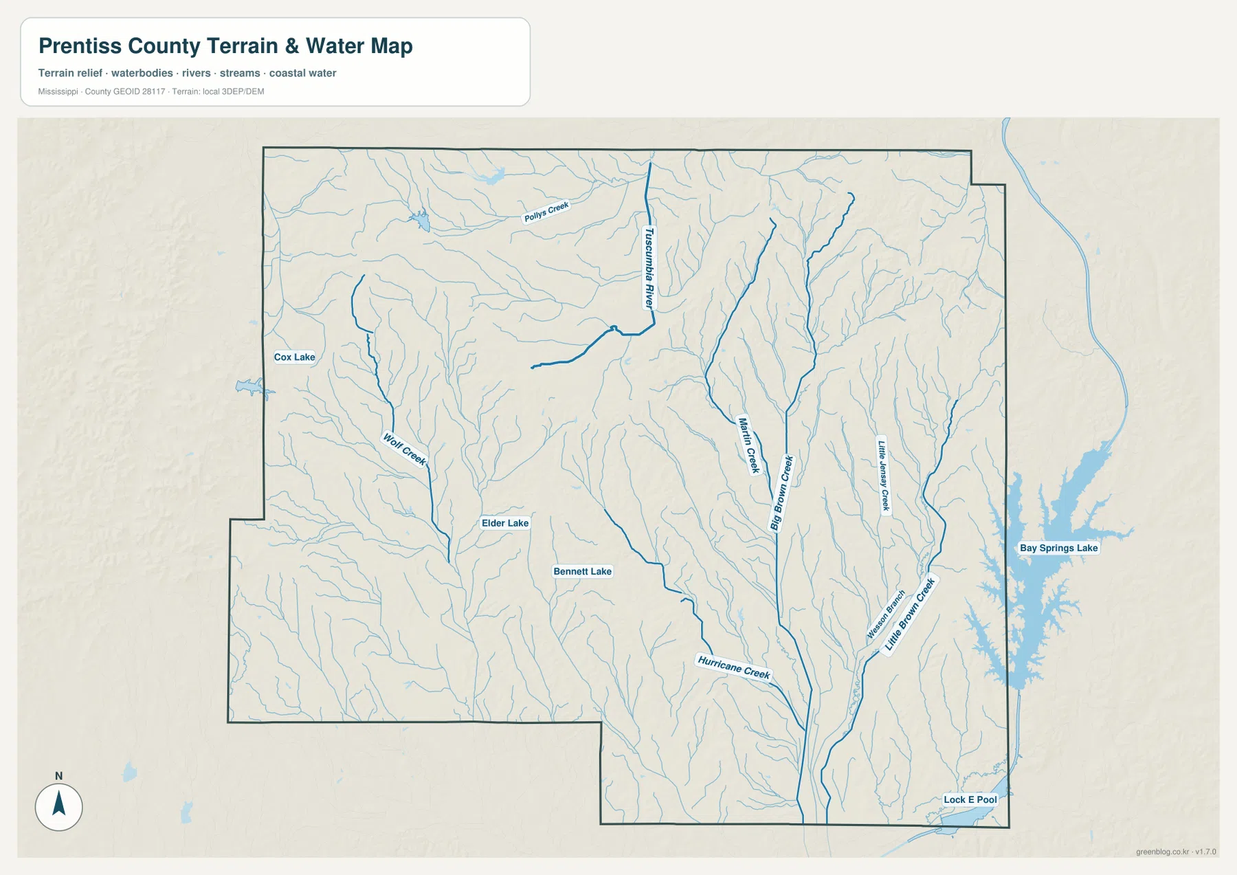
Tuscumbia River and a dense network of creeks
The water-and-terrain map shows a drainage system made up of many narrow channels. Tuscumbia River is one of the strongest named waterways in the north-central area. Martin Creek runs through the eastern interior, and Camp Branch forms another long drainage line farther east. Little Massey Creek, Western Branch, and Little Brown Creek are labeled along the eastern side, while Hurricane Creek crosses the southern interior. On the western half, Wolf Creek is prominent, and Follys Creek appears near the northwestern part of the county. Numerous unnamed tributaries connect those channels and create a closely spaced pattern of valleys.
Several small lakes are also labeled. Cox Lake is near the western edge, Elder Lake appears in the west-central area, and Bennett Lake lies farther southeast. Bay Springs Lake is visible beyond the eastern county boundary and should not be mistaken for an interior Prentiss County lake simply because it appears on the same map. The page is intended as a reference for the location of rivers, creeks, and water bodies. It is not a flood-hazard map, a parcel survey, a navigation chart, or a legal source for determining access to waterfront land.
High northern ridges above lower central and southern valleys
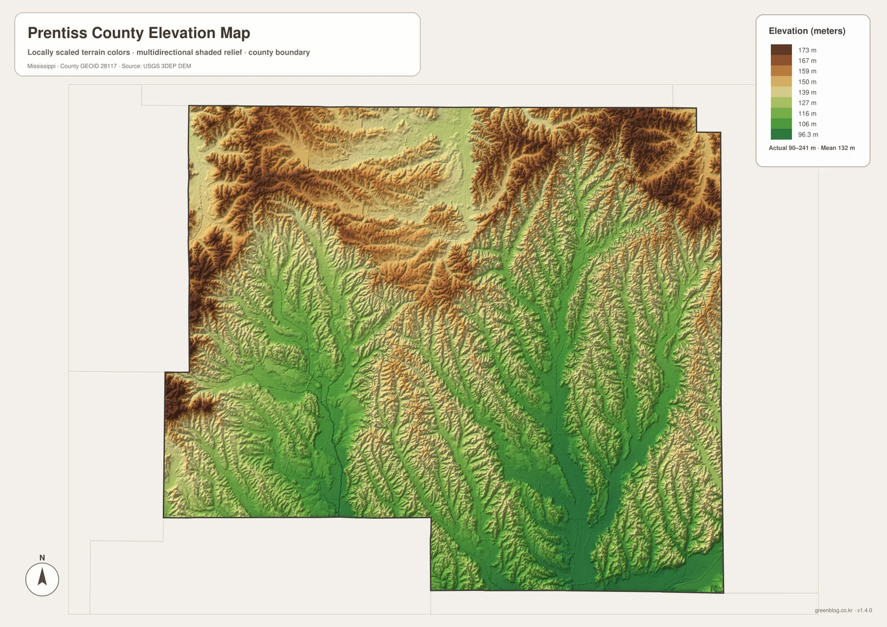
The elevation map lists an actual range of about 90 to 241 meters, with a mean elevation of about 132 meters. The color legend itself concentrates on a narrower set of locally scaled values, but the printed actual range is the better summary for the county as a whole. Brown and tan ridges are especially dense across the north and northeast. High ground is also visible in the northwest, where narrow valleys cut between repeated ridgelines. The center and south contain broader green corridors that mark lower terrain.
Comparing this view with the water map explains much of that shape. The lower green corridors follow drainage valleys, while the higher ridges occupy the ground between tributaries. The eastern half contains many branching low valleys separated by narrow hills, and the central-southern part opens into a wider low area before reaching the bottom of the county. Wolf Creek on the west and the Tuscumbia River system farther east fit the same overall relationship: water follows lower ground, while the surrounding ridges rise above it.
This relief is useful for understanding the county at a broad scale, but the elevation surface is not survey-grade. It should not be used to determine the precise elevation of a building site, calculate a road grade, design drainage, or make an engineering decision. For those purposes, a project-specific survey or detailed elevation dataset is necessary. Here, the practical value is seeing where the major ridge country stands above the lower stream valleys.
Population and area add scale to the map
The supplied Census references list a 2020 census population of 25,008 and a July 2025 population estimate of 25,284 for Prentiss County. Those figures come from different reference dates and should be treated as separate benchmarks rather than as measurements taken at the same time. The supplied 2025 Gazetteer figures list 414.985 square miles of land and 3.214 square miles of water. That small amount of open-water area is consistent with what the water map shows: streams and narrow channels are common, but large lakes occupy only a limited part of the mapped county.
The numbers also put the city map in perspective. Booneville is the largest selected community, yet the county extends far beyond the city into wooded ridges, creek valleys, and rural road networks. Jumpertown and Marietta are much smaller and lie in different directions from the hub. A countywide population figure therefore describes a landscape made up of both settlements and broad nonurban areas. It should not be read as if people were distributed evenly across every ridge, creek valley, and road corridor.
Which Prentiss County map is most useful for your task?
Use the general county map when you need the county edge, major roads, and several place names together. The city-connections map is better when the question is simply how Booneville relates to Jumpertown and Marietta or when you want the straight-line distances shown on the graphic. The water map carries the most detail for Tuscumbia River, named creeks, and small lakes. For terrain, the elevation map gives the clearest view of the northern ridges and the lower valleys that extend through the center and south. In a report or classroom presentation, pairing the county map with either the water or elevation view can explain both location and physical setting without crowding one image with every detail.
Frequently Asked Questions
Is Baldwyn entirely inside Prentiss County?
No. The supplied current article identifies Baldwyn as extending across the Prentiss-Lee county line, and the general map places the city near the southwestern boundary. Read the municipal label together with the county boundary rather than assuming the whole city lies in one county.
How far are Jumpertown and Marietta from Booneville on the city map?
The city-connections map labels Jumpertown at about 6 miles from Booneville and Marietta at about 13 miles. Those values are direct straight-line distances between mapped points, not road mileage, so actual driving distance will be different.
What elevation range is shown for Prentiss County?
The supplied elevation map prints an actual range of roughly 90 to 241 meters and a mean of about 132 meters. The highest-looking terrain is concentrated across the north and northeast, while lower valleys extend through the central and southern drainage corridors.
Map File Information
The ZIP contains the supplied Prentiss County county, city, water, and elevation maps as high-resolution A3 JPG files. These originals are larger than the WebP page previews and are suitable for printing, editing, classroom materials, and location-reference graphics.
- File Type: four high-resolution JPG files in one ZIP
Related Maps
Sources and References
- U.S. Census Bureau QuickFacts for Prentiss County — population reference
- U.S. Census Bureau Gazetteer Files — land and water area reference
- Mississippi Department of Transportation Official Highway Map — major route reference
- USGS National Hydrography — river, creek, and waterbody reference
- USGS 3D Elevation Program — terrain and elevation reference
- Northeast Mississippi Community College — Booneville-area institutional reference
Green Map creates custom-edited map images using open geographic data sources such as geoBoundaries, Natural Earth, OpenStreetMap, and government open data. These maps are edited visual materials, not raw data files, and are provided for education, documents, presentations, and graphic reference.