Marion County in north-central Arkansas is a rugged Ozark county centered on Yellville, with deeply cut creek valleys, broad ridges, and two very different major water landscapes. Bull Shoals Lake spreads through the northeastern side in long branching arms around Bull Shoals, while the Buffalo River follows a much narrower valley along the southeastern edge. Yellville and Flippin sit closer to the middle of the county, and Pyatt lies well to the west. This page shows communities, roads, rivers, creeks, the reservoir shoreline, and an actual elevation range of about 114 to 409 meters. The same four maps are available as high-resolution JPG files in one downloadable ZIP.
Yellville is the county seat and the most useful reference point for reading the maps. The Encyclopedia of Arkansas identifies Yellville as the seat of Marion County and places the town on Crooked Creek. On the general map, Routes 62 and 412 pass through the central area, with Routes 334 and 202 connecting toward Flippin. From Yellville, the landscape changes in every direction: Pyatt lies across higher western ridges, Bull Shoals is separated by the lake-dominated northeast, and the Buffalo River valley is far to the southeast.
Table of Contents
Start at Yellville and Flippin to understand the central road network
Routes 62 and 412 provide the clearest east-west reference through the central part of Marion County. They enter from the Pyatt side and reach the Yellville area, where Routes 334 and 202 help connect the county seat with Flippin. South of Yellville, Routes 14 and 206 extend into a much more rural hill-and-valley landscape, while Routes 125 and 235 appear farther southwest. The road system is easier to understand when it is divided into directions from Yellville rather than treated as one long list of route numbers.
North of Flippin, Route 178 climbs toward Bull Shoals. Routes 345 and 101 serve parts of the eastern side, where the county boundary becomes increasingly irregular around lake arms and lower river valleys. Bull Shoals sits on a narrow section of land surrounded by water on several sides, so the route pattern is much more constrained than around Yellville. Oakland is farther northeast near the county edge, separated from the central road network by the broad Bull Shoals Lake system.
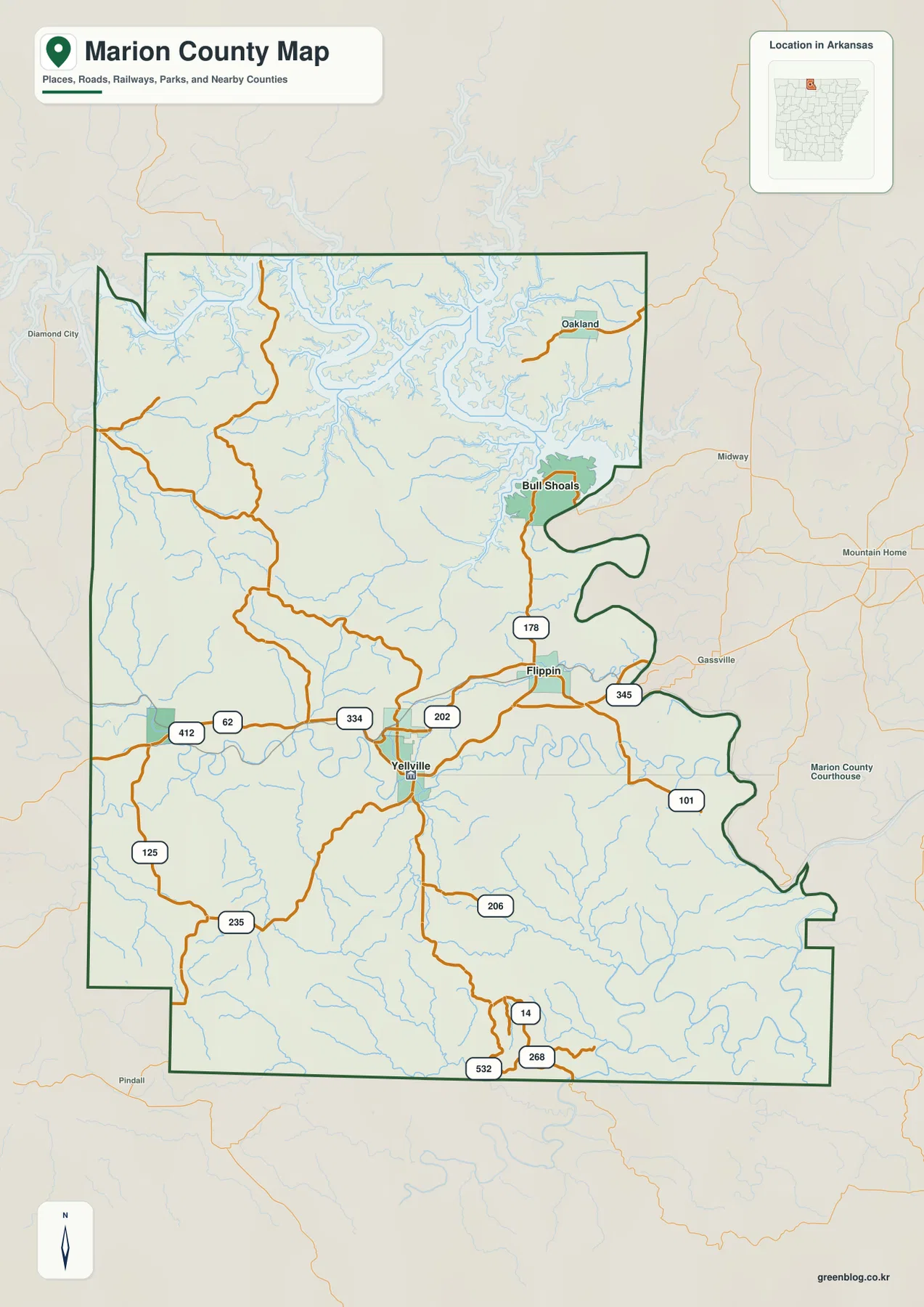
The northeastern county outline is unusually complicated because of Bull Shoals Lake and the White River system. The Encyclopedia of Arkansas notes that the lake effectively splits Marion County, leaving the northeastern corner with indirect road access to the county seat and requiring some residents to travel through Baxter County. That unusual geography is easy to see on the map: long lake arms cut into the county and leave narrow land connections around Bull Shoals. The southern boundary, by comparison, contains much longer straight segments.
The ranked city map separates the Bull Shoals lake community from the central towns
The city map ranks five major communities. Bull Shoals is number 1, Flippin 2, Yellville 3, Summit 4, and Pyatt 5. These numbers are ranking markers rather than distance measurements. Bull Shoals occupies the northeastern lake area, while Flippin, Yellville, and Summit form a looser central cluster. Pyatt is separated farther west. The layout makes Marion County look less like a single settlement corridor and more like several communities divided by ridges, creek valleys, and the large reservoir.
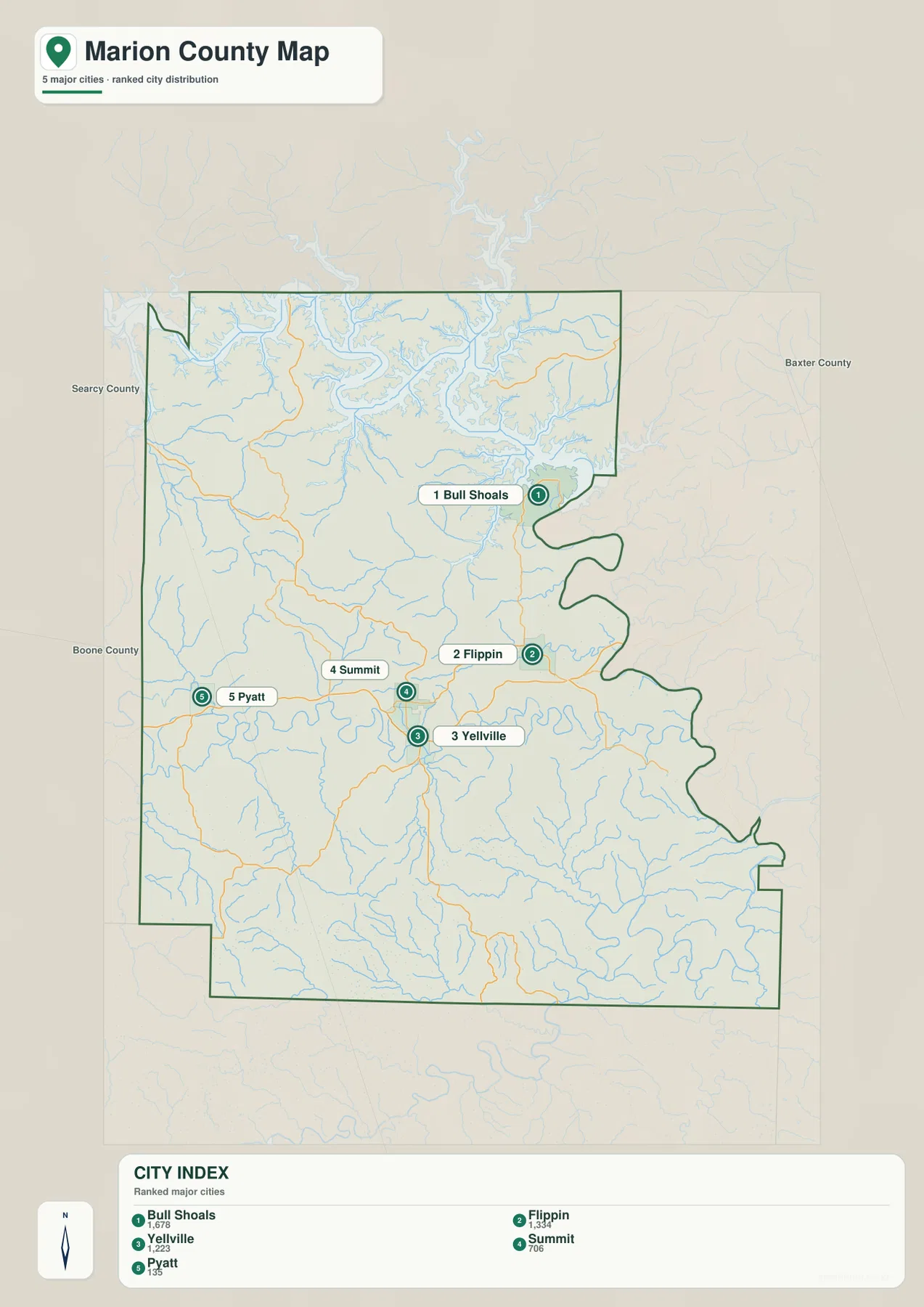
Comparing the city map with the general road view makes the differences between those communities more meaningful. Flippin and Yellville sit near the main east-west road corridor, and Summit is close to Yellville. Bull Shoals is physically separated by lake arms and lower White River terrain, while Pyatt lies beyond higher western ridges. In Marion County, direct position on a simple city map is only part of the story; water and relief strongly affect how those communities connect by road.
The city legend includes numeric values beside the community names, but this article does not reinterpret those figures as current population estimates. The supplied map clearly supports the ranking and geographic positions of the five communities, so those are the facts used here. Current population totals should be checked against recent Census data. Yellville’s county-seat status and Bull Shoals’ strong relationship with the lake are supported separately by county-specific sources.
Bull Shoals Lake and White River dominate the northeast
Bull Shoals Lake is the most visually dominant water feature on the terrain and water map. The reservoir occupies much of the north and northeast, with long arms extending between Ozark ridges. The White River label appears along the northern water corridor, and the lake surrounds the Bull Shoals area on multiple sides. County and lake history sources tie the modern community of Bull Shoals directly to the dam and reservoir, which helps explain why this northeastern corner looks so different from the rest of the county.
South of the reservoir, Sister Creek and Jimmie Creek descend through narrow valleys toward the lake. Fallen Ash Creek winds across the east-central interior, while Crooked Creek crosses the central-eastern part of the county near the Yellville area. East Sugarloaf Creek is labeled in the northwest. Many smaller tributaries fill the space between these named waterways, so the terrain and water map is especially useful for seeing how almost every ridge is separated from the next by a creek valley.
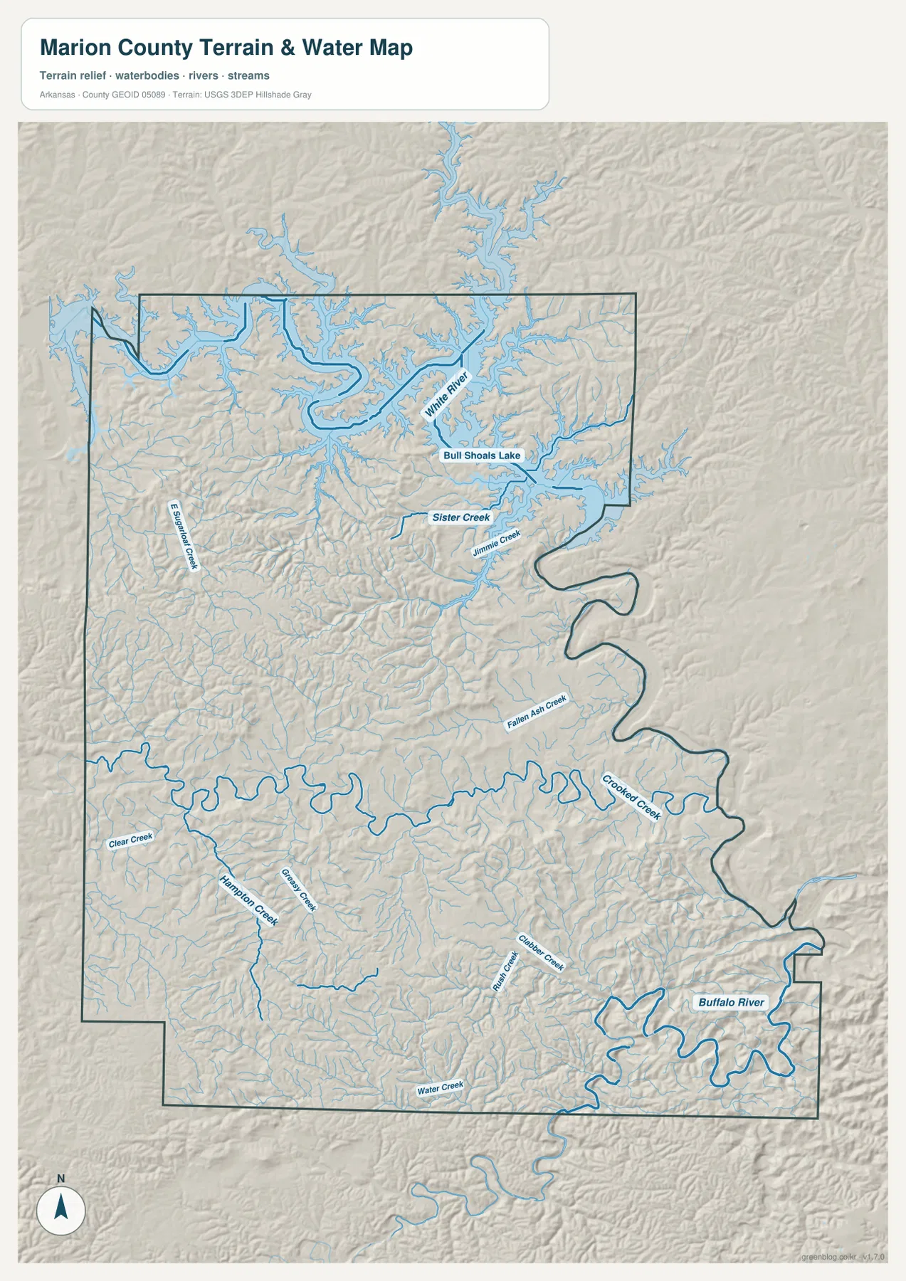
Farther south and west, Clear Creek, Hampton Creek, Greasy Creek, Clubbs Creek, Rush Creek, and numerous unnamed tributaries occupy separate valleys. These streams do not create a broad open water surface like Bull Shoals Lake, but they shape the interior terrain by cutting long green corridors between higher ridges. On this map, the distinction between ridge and valley is often easier to see by following the blue creek lines than by looking at hill shading alone.
The Buffalo River appears along the southeastern edge as a broad, winding channel in a deeply cut valley. It provides a strong contrast with the reservoir landscape in the northeast. One side of Marion County contains a large impounded lake with branching coves, while the other contains a narrow river valley enclosed by hills. The map is intended for general geographic reference, not for current water level, flood or whitewater safety, fishing regulations, property boundaries, or live road access. Current agency information should be used before any on-the-water activity.
Elevation ranges from 114 to 409 meters across tightly packed Ozark ridges
The supplied elevation map shows an actual countywide range of about 114 to 409 meters, with a mean near 265 meters. That is roughly 295 meters of relief. Higher brown and tan terrain is concentrated across the western interior and southwest, while the Bull Shoals Lake and White River valleys are much lower and greener. The county is not arranged as one high side and one flat side; ridges and creek valleys repeat across nearly the entire map.
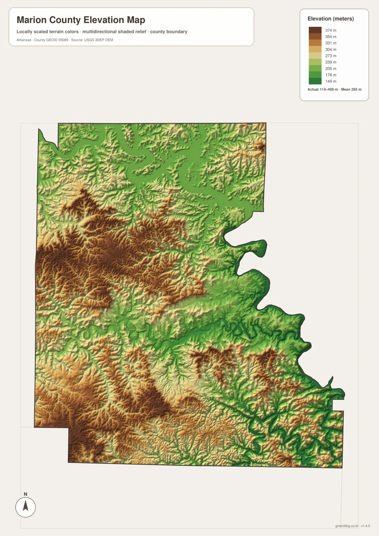
The western interior is made up of long branching ridges rather than one isolated high summit. Clear Creek, Hampton Creek, and other streams occupy lower corridors between those ridges, and the roads between Yellville and the Pyatt side bend through the same broken terrain. The southwest has another broad area of higher ground, again cut by numerous valleys. That repeated relief is one reason the map feels much more complex than a simple county outline might suggest.
The northeast drops toward Bull Shoals Lake and the White River corridor, where long green valleys extend beneath the reservoir arms. Higher ridges remain in the southeast, but the Buffalo River and its tributaries create deep low corridors between them. The elevation map is therefore most useful for comparing ridge-and-valley density rather than simply locating a single high point. It is not a survey map; exact parcel, road, bridge, or building elevations require original USGS elevation data or professional measurement.
Compare Bull Shoals and the Buffalo River from Yellville
A practical way to use the four maps together is to begin at Yellville and compare the northeast with the southeast. Heading toward Flippin and Bull Shoals brings the road network into lower White River terrain and then into a landscape dominated by reservoir arms. The county boundary becomes irregular, and road choices narrow as water cuts between the ridges. The water and elevation maps reinforce the same change, with broad blue lake surfaces replacing many of the ordinary creek valleys.
The southeastern direction is almost the opposite. Major towns disappear, the road network becomes sparse, and high Ozark ridges are divided by narrow creek valleys before reaching the Buffalo River. Looking west toward Pyatt adds a third comparison, where higher interior ridges and smaller creeks dominate without the huge lake. Marion County is therefore particularly well suited to a multi-map view: the same county includes a lake-separated northeast, a central road corridor, rugged western uplands, and a deep river valley in the southeast.
High-resolution JPG files for Yellville roads, Bull Shoals Lake, and river valleys
The WebP images in the article are optimized for quick page viewing. The download ZIP contains the same four maps as high-resolution JPG files, each measuring 2572 × 3638 pixels in portrait orientation. Use the general map for Yellville, Flippin, Bull Shoals, Pyatt, and major roads; the ranked city map for the five main communities; the terrain and water map for Bull Shoals Lake, White River, Crooked Creek, Buffalo River, and smaller streams; and the elevation map for comparing the county’s 114–409 meter ridge-and-valley relief.
The JPG files are suitable for classroom reference, presentations, trip preparation, personal printing, and general orientation. They should not replace legal boundary records, parcel surveys, flood or whitewater safety information, boating regulations, engineering plans, or live navigation. When exact or current information is required, consult Census TIGER/Line boundaries, USGS hydrography, USGS elevation data, and the appropriate water-management or recreation agency.
Frequently Asked Questions
What is the county seat of Marion County?
Yellville is the county seat. It sits near the center of Marion County along Crooked Creek, with Routes 62 and 412 and several local routes nearby. That central position makes Yellville the easiest reference point for comparing Flippin, Bull Shoals, Pyatt, and the county’s major water features.
Why does Bull Shoals Lake make northeastern Marion County unusual?
Long arms of Bull Shoals Lake cut deeply into the northeastern side and leave narrow land connections around Bull Shoals. County reference sources note that the lake effectively divides the county, and some travel from the northeastern section to Yellville requires routing through Baxter County. The unusual road and boundary pattern is easy to see by comparing the general and water maps.
How much elevation change is shown across Marion County?
The supplied elevation map shows an actual range of about 114–409 meters with a mean near 265 meters. Higher terrain is widespread across the western and southwestern interior, while the Bull Shoals Lake, White River, and Buffalo River valleys occupy much lower ground.
Map File Information
The ZIP contains the general county map, ranked city map, terrain and water map, and elevation map as high-resolution JPG files for printing or offline reference.
- File Type: ZIP containing 4 JPG files
Related Maps
Sources and references
- Encyclopedia of Arkansas – Marion County – county seat, Bull Shoals Lake, White River, and county geography
- Encyclopedia of Arkansas – Yellville – Yellville, Crooked Creek, and county-seat information
- Encyclopedia of Arkansas – Bull Shoals Dam and Lake – Bull Shoals Lake and White River background
- U.S. Census Bureau TIGER/Line Shapefiles – county boundary and road data
- USGS National Hydrography – rivers, streams, lakes, and hydrography data
- USGS 3D Elevation Program – elevation and terrain data
Green Map creates custom-edited map images using open geographic data sources such as geoBoundaries, Natural Earth, OpenStreetMap, and government open data.
These maps are edited visual materials, not raw data files, and are provided for education, documents, presentations, and graphic reference.