You can download four high-resolution A3 JPG maps of Matagorda County, Texas, in one ZIP directly from this page. The package includes a general county map, a ranked city map, a terrain-and-water map, and an elevation map. Together they show Bay City, Palacios, Van Vleck, Markham, Blessing, Wadsworth, Sargent, Matagorda, roads 111, 71, 35, 60, and 129, the Colorado and Tres Palacios river systems, coastal bays and waterways, and an actual elevation range of about -1 to 22 meters.
Bay City is the easiest place to begin because it sits in the inland center of the county, while Palacios, Matagorda, and Sargent provide clear references closer to the coast. The road map shows a fairly straightforward network around Bay City, but the water map changes the picture completely: the Colorado River runs south through the county, Tres Palacios River drains the west, and Caney Creek, Live Oak Bayou, and other channels spread across the east before reaching the coastal bays. The elevation layer confirms how low this landscape is, with a mean elevation of only about 7 meters.
Table of Contents
Bay City provides the clearest road reference for the inland county
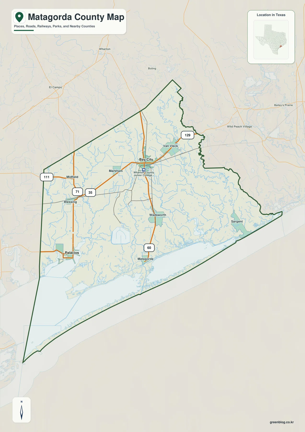
Bay City is the strongest settlement label on the general map. The urban area sits slightly north of the county’s center, with Wharton County Junior College marked nearby. Route 35 runs westward from the Bay City area toward Markham and the Blessing corridor, while Route 60 heads south through Wadsworth toward Matagorda. These two directions make Bay City a practical starting point for reading the entire county.
Farther west, Route 111 is labeled near Midfield, and Route 71 appears near Blessing. Palacios lies in the southwest close to the coastal water, separate from Bay City’s inland urban area. Van Vleck is east-northeast of Bay City, with Route 129 shown nearby. The main roads therefore connect a series of inland and coastal communities rather than forming one single urban corridor.
The eastern side looks less road-dominated. Sargent is labeled close to the coast, where streams and tidal-looking channels occupy much of the map. Matagorda sits farther south near the Colorado River outlet area. By the time the map reaches these coastal communities, water and lowland geography become as important as the highway network for understanding location.
The ranked city map separates inland Bay City from coastal Palacios
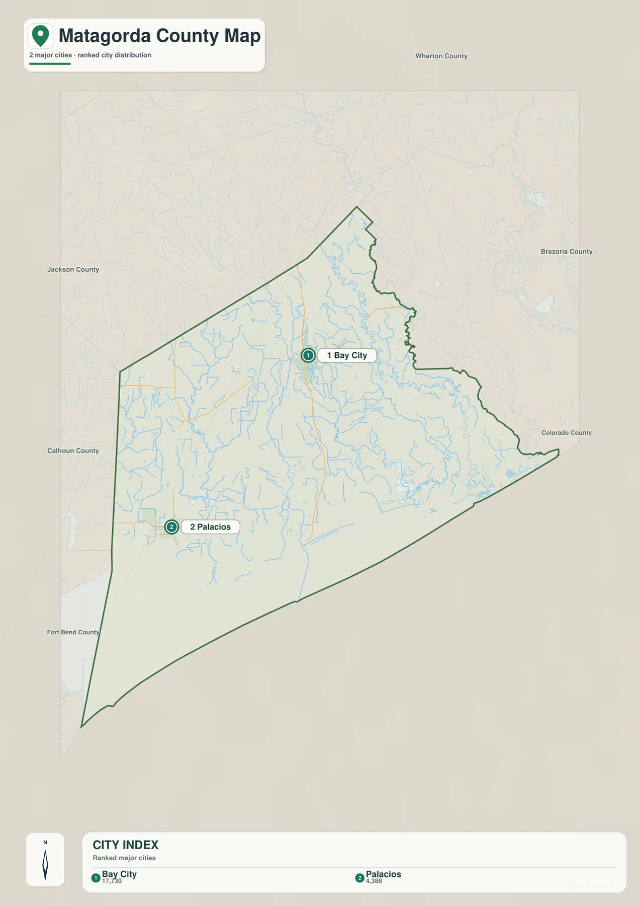
The city map ranks two major communities: Bay City first and Palacios second. The lower index also prints the values 17,730 and 4,388 beside the two names. The supplied map does not identify a year for those figures, so this article treats them as values shown in the city index rather than presenting them as confirmed current population counts.
The spatial contrast is more useful than the ranking itself. Bay City lies in the inland central-northern part of Matagorda County, while Palacios sits much farther southwest near the coast. Between them are communities such as Markham and Blessing on the general map, along with an extensive network of streams and low-lying land. The simplified city view makes that inland-versus-coastal difference immediately visible.
Wharton, Jackson, Calhoun, Fort Bend, Brazoria, and Colorado counties are labeled outside the boundary for regional orientation. The city map is useful when the goal is simply to place Bay City and Palacios. The general map is better for finding smaller communities, route numbers, and the different approaches to the coast.
Colorado River forms the strongest north-to-coast water corridor
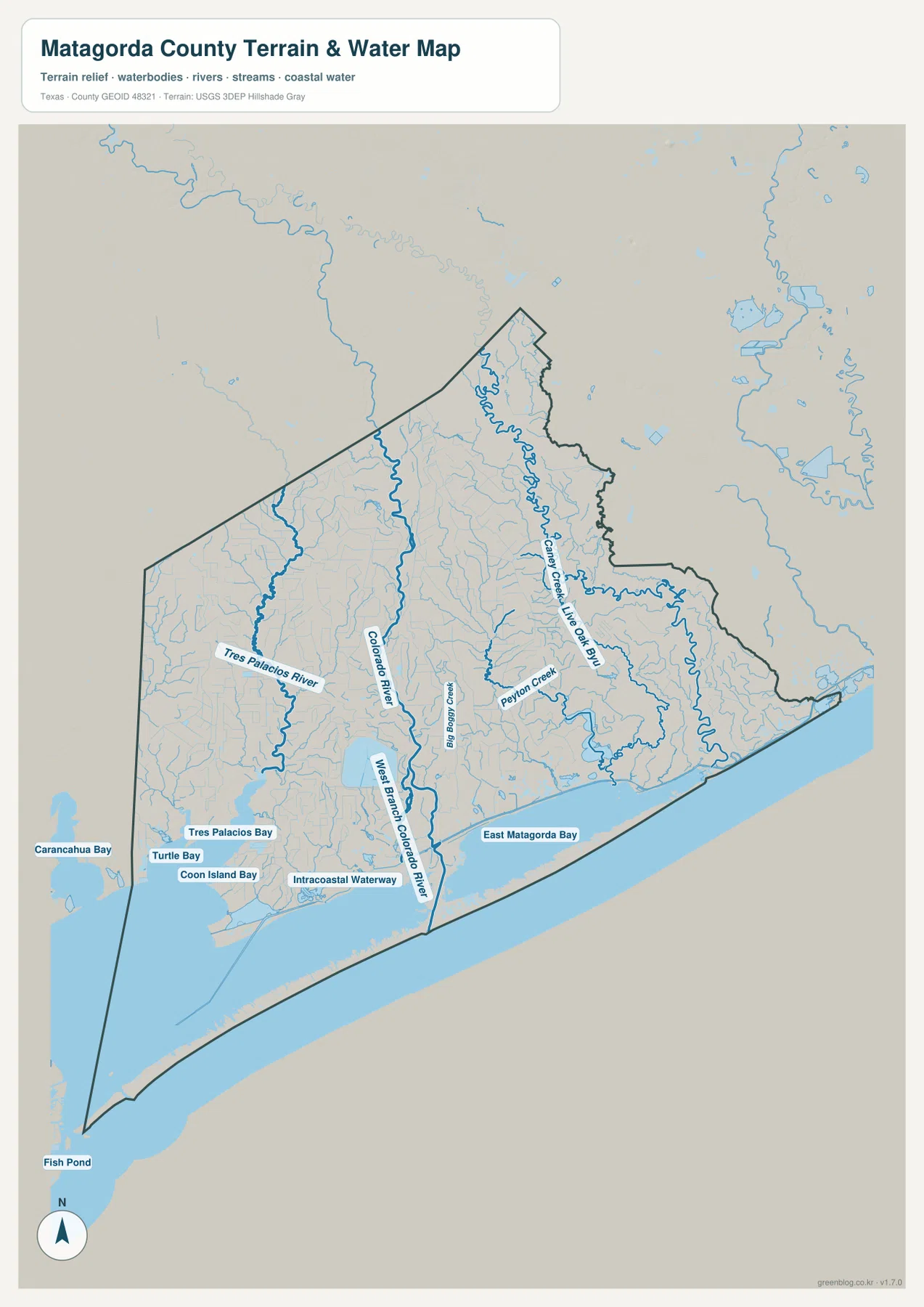
The Colorado River is the most prominent named water feature on the terrain-and-water map. It enters from the north, follows a winding path through the middle of the county, and continues toward the coast. Near the lower section, West Branch Colorado River is labeled separately. Using Bay City and Matagorda as reference points on the general map makes it easy to match this major river corridor across both views.
West of the Colorado, Tres Palacios River creates another strong north-to-south drainage line. Near the coast, Tres Palacios Bay, Turtle Bay, and Coon Island Bay are labeled close together. The Intracoastal Waterway runs along the coastal margin, showing how inland rivers, protected bays, and the long coastal route come into close proximity in the southern county.
Caney Creek and Live Oak Bayou cross the eastern lowlands toward East Matagorda Bay
The eastern half has a different drainage pattern from the Colorado River corridor. Caney Creek and Live Oak Bayou are clearly labeled, and Peyton Creek and Big Boggy Creek add separate tributary routes through the same broad lowland. The density of waterways explains why the Sargent side of the general map appears much more irregular than the inland road network around Bay City.
East Matagorda Bay occupies a large coastal area in the southeast. Numerous smaller channels approach the bay from inland, while the outer coastal water and narrow barrier-like landforms define the southern edge of the county map. This gives Matagorda County a strong transition from inland road and river country to a shoreline landscape dominated by bays, channels, and very low terrain.
The water layer is intended for geographic reference. It can help locate the Colorado River, Tres Palacios River, Caney Creek, Live Oak Bayou, named bays, and the Intracoastal Waterway relative to communities and the county boundary, but it is not a flood-hazard map, legal shoreline product, parcel map, or navigation chart. For road access, match the same location back to the general map.
A very low elevation range still reveals an inland-to-coast gradient
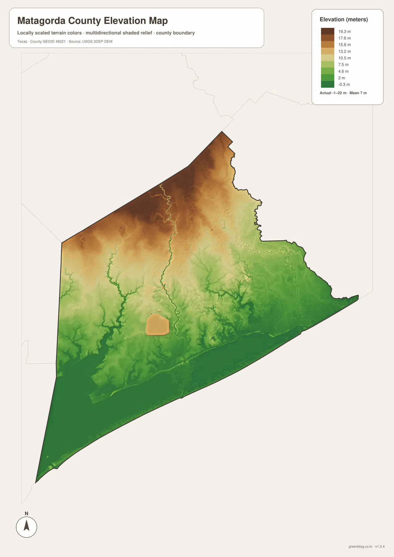
The elevation map reports an actual range of about -1 to 22 meters and a mean elevation of about 7 meters. This is a very low-relief county, but the color pattern is still informative. Browns and tans are most common across the north and northwest, while greens spread widely across the south and east. The immediate coast and bay margins occupy the lowest broad terrain.
Colorado River and Tres Palacios River appear as narrow lower corridors running toward the coast. The eastern drainage network around Caney Creek and Live Oak Bayou also occupies broad green lowlands. Comparing the water and elevation maps makes it clear that the river and bay systems are embedded in the lowest parts of the county rather than crossing a uniform flat surface.
The difference between the displayed minimum and maximum elevation is only about 23 meters. In a coastal county, however, that small range still separates slightly higher inland ground from the lowest river, bay, and shoreline areas. The northern end remains visibly higher on the color ramp, while the southern coast forms a long band of low green terrain.
The elevation layer is best used for relative terrain comparison. It should not be treated as a flood-risk model, engineering survey, or precise local elevation measurement. Its main value here is to show how Bay City and the northern interior sit slightly above the broad coastal lowlands around Matagorda, Palacios, Sargent, and the major bays.
Following Bay City south connects the road, river, and coastal maps
Start at Bay City on the general map and follow Route 60 south toward Wadsworth and Matagorda. On the water map, the Colorado River follows the same broad north-to-coast direction and eventually splits around the lower river system. The elevation map shows that the terrain becomes progressively lower toward the coast, linking the road corridor with the river and the coastal plain.
The southwest offers a second comparison. Blessing and Palacios are connected by the road network, but the water map adds Tres Palacios River, Tres Palacios Bay, Turtle Bay, and Coon Island Bay. The elevation view remains broadly green in this area, reinforcing the close relationship between the coastal settlement and the low bay landscape.
Use the ranked city map for a quick Bay City–Palacios comparison, the general map for road numbers and additional communities, the terrain-and-water map for rivers, bayous, bays, and coastal channels, and the elevation map for the subtle inland-to-coast change in height. Smaller labels are often easier to inspect in the downloadable high-resolution JPG files than in the browser previews.
Frequently Asked Questions
Which communities are ranked on the Matagorda County city map?
The map ranks Bay City first and Palacios second. Bay City lies in the inland central-northern part of the county, while Palacios sits far to the southwest near the coast. The numerical values in the city index are not dated on the supplied image, so this article does not present them as confirmed current population counts.
Which rivers and coastal waters are easiest to identify?
Colorado River is the main central reference. Tres Palacios River lies to the west, while Caney Creek and Live Oak Bayou cross the eastern side. East Matagorda Bay, Tres Palacios Bay, Turtle Bay, Coon Island Bay, and the Intracoastal Waterway are also labeled on the supplied map.
What elevation range is shown for Matagorda County?
The supplied elevation map reports an actual range of about -1 to 22 meters and a mean of about 7 meters. The northern interior is slightly higher, while the river corridors, coastal bays, and shoreline areas occupy the lowest terrain.
Sources and Reference Data
- U.S. Census Bureau TIGER/Line Shapefiles — official county-boundary and road geometry for geographic reference.
- USGS National Hydrography — official resources for rivers, creeks, bayous, and inland water features.
- USGS 3D Elevation Program — official elevation resources used for terrain information.
- USGS The National Map Viewer — an official viewer for comparing geographic layers.
Map File Information
Download four high-resolution A3 JPG maps of Matagorda County, Texas, in one ZIP file.
- Included Files: county map, ranked city map, terrain and water map, elevation map
- File Type: JPG
Related Maps
- Wharton County Texas map
- Aransas County Texas map
- Refugio County Texas map
- Victoria County Texas map
- Austin County Texas map
Green Map creates custom-edited map images using open geographic data sources such as geoBoundaries, Natural Earth, OpenStreetMap, and government open data.
These maps are edited visual materials, not raw data files, and are provided for education, documents, presentations, and graphic reference.