Cherokee County sits where the northern edge of metro Atlanta begins to break into the ridges and stream valleys of North Georgia. Woodstock and Holly Springs occupy the more developed south, Canton anchors the middle of the county, and Ball Ground, Waleska, and Nelson spread farther north. I‑575 ties much of that settlement pattern together, while the Etowah River, Allatoona Lake, and rising terrain explain why the county looks very different once you move away from the highway corridor.
This page provides four map views of the same county: a general county map, a ranked city map, a water map, and an elevation map. You can inspect the WEBP previews in the article and download one ZIP containing all four original high-resolution JPG files. Use the general map for roads and orientation, the city map for settlement positions, the water map for rivers and reservoirs, and the elevation map when the shape of the land matters.
Table of Contents
A county between Atlanta suburbs and North Georgia hills
Cherokee County lies north of Atlanta with Cobb and Fulton counties on the more urbanized southern side, Bartow County to the west, Pickens County to the north, Dawson County toward the northeast, and Forsyth County to the east. That position is useful context for the map because the county is not uniformly suburban. Development is strongest near the southern boundary and I‑575, while the northern and western parts contain more wooded ridges, valleys, and larger open tracts.
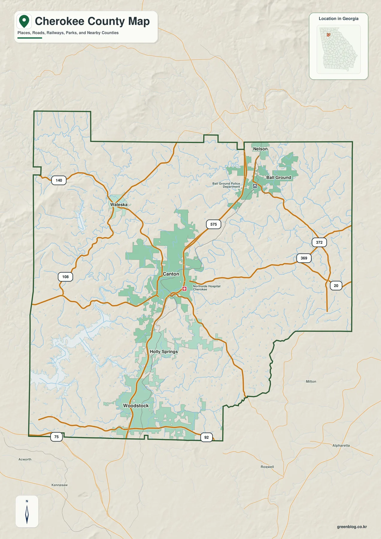
Canton appears near the center of the county and gives the map an easy reference point. Woodstock and Holly Springs are south of Canton, Ball Ground and Nelson are to the north and northeast, and Waleska is northwest. Nearby labels outside the county, including Milton, Alpharetta, Roswell, Acworth, and Kennesaw, help show how close the southern part of Cherokee is to the broader Atlanta suburban network.
I‑575 is the clearest north-south route on the map. SR 20 crosses the Canton area, SR 92 runs across the southern end near Woodstock, and SR 140 leads west and northwest toward Waleska. The map also shows SR 369 and SR 372 in the eastern half. Looking at the roads as connections between named places is more useful than treating the route numbers as a list: the highway corridor explains why the largest mapped cities line up through the southern and central county.
The county map is a locator rather than a legal survey. It is useful for seeing the overall boundary, towns, roads, and surrounding places, but it does not establish parcel lines, school zones, municipal jurisdiction, flood status, or road ownership. Those questions require current records from Cherokee County or the responsible state and federal agencies.
Where the six mapped cities sit
The city map ranks six labeled places and makes the settlement pattern easier to compare. Woodstock is shown first, followed by Canton, Holly Springs, Ball Ground, Nelson, and Waleska. The ranking is useful, but the strongest visual point is their distribution: the top three are concentrated along the southern-to-central I‑575 corridor, while the smaller northern places are separated by more rural and hilly terrain.
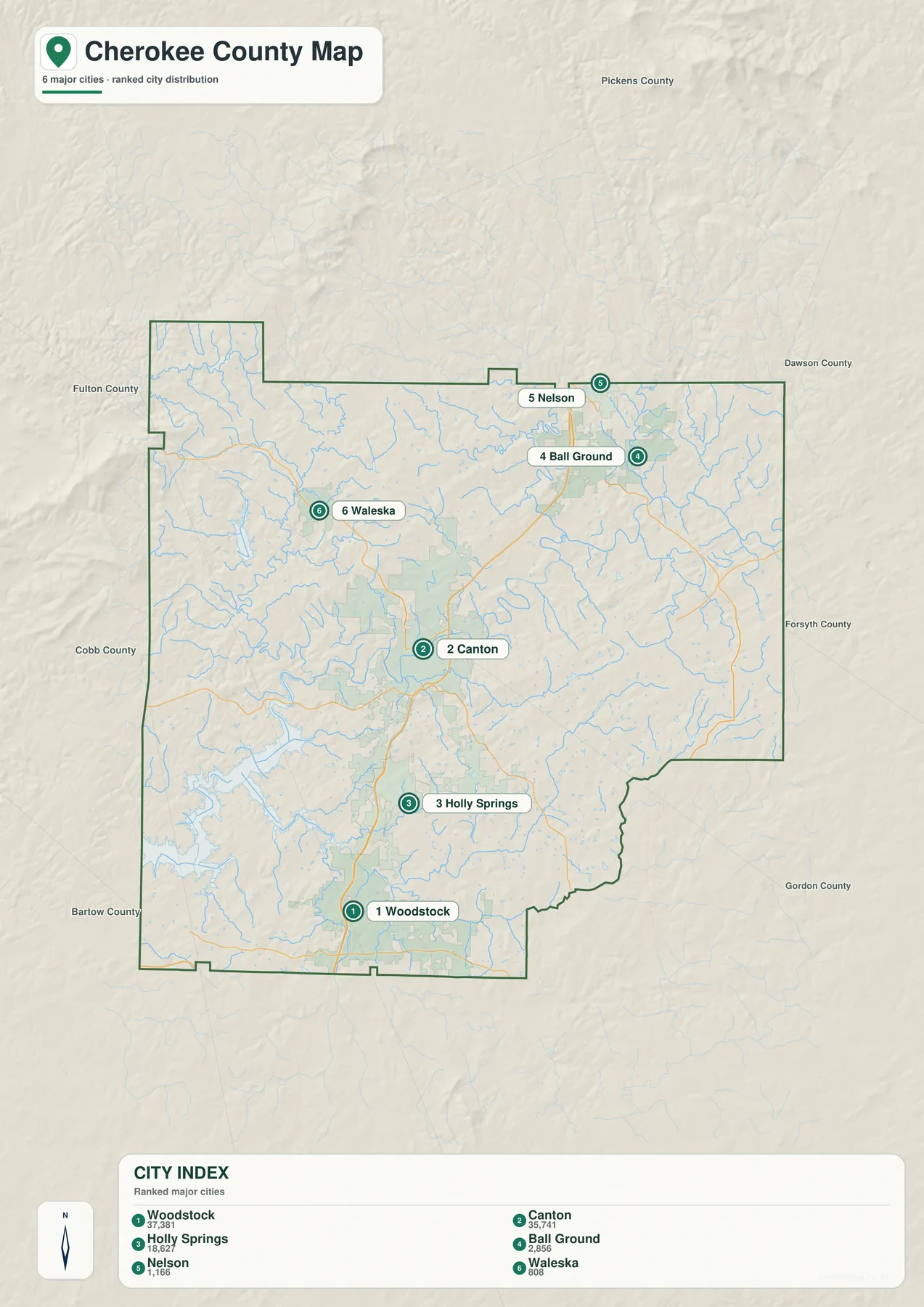
Starting at the Cobb County side and moving north, Woodstock comes first, then Holly Springs, then Canton. That sequence follows the main highway and forms the county’s most continuous developed corridor. Canton differs from the two southern cities because it is also the county seat and the point where SR 20 crosses the north-south route. This combination of central location and intersecting roads makes Canton a practical anchor when reading any of the four maps.
Ball Ground lies northeast of Canton on the northbound approach, whereas Waleska is off to the northwest and depends more on SR 140 and local roads for its map position. Nelson sits near the northern county line. Those locations explain why a reader should not assume that every city label is centered within Cherokee County or that all communities share the same transportation pattern.
The older county article records a 2020 census population of 266,620 and a July 1, 2025 estimate of 299,273, a 12.2 percent increase from the 2020 estimates base. The 2025 figure is an annual estimate, not a second decennial census. The county’s 2023 comprehensive plan also describes population and traffic pressures around incorporated cities, the Cobb County line, and the I‑575 corridor, which matches the south-to-central concentration visible on the maps.
The Etowah River, Allatoona Lake, and branching creeks
Water is a major part of Cherokee County’s map pattern. The Etowah River enters from the east, passes through the Canton area, and continues southwest toward Allatoona Lake. Little River drains the southern part of the county toward the lake, while smaller streams fill the spaces between ridges and developed areas. The water map strips away much of the road emphasis so these connections are easier to follow.
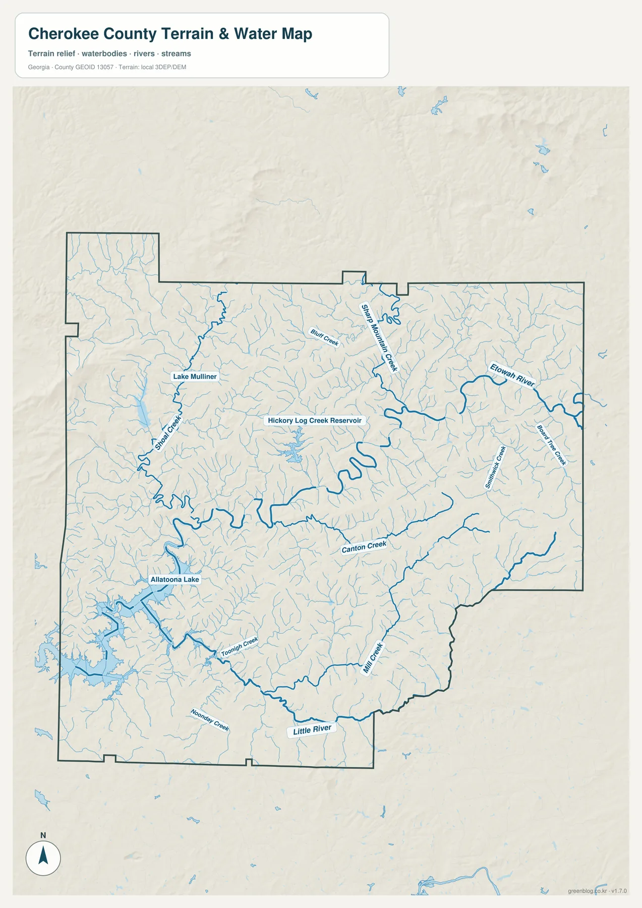
Several named tributaries are visible, including Canton Creek, Mill Creek, Toonigh Creek, Noonday Creek, Sharp Mountain Creek, and other small channels. Hickory Log Creek Reservoir is labeled near the central-northern part of the county. In the west and southwest, the branching arms of Allatoona Lake are much broader than the narrow upstream creeks, creating a shoreline that cuts deeply into the surrounding land.
That shoreline matters when comparing map distance with real travel. Two points can appear close across a lake arm or stream valley but require a longer road route to reach a bridge or crossing. The U.S. Army Corps of Engineers manages Allatoona Lake, and the county’s planning materials treat the lake, streams, wetlands, and protected natural areas as important parts of the local landscape.
This is a water-reference map, not a flood map or navigation chart. It does not determine flood exposure, water depth, boating access, property rights, or legal shoreline boundaries. For those questions, use current FEMA, county, USGS, or U.S. Army Corps of Engineers resources rather than the page image.
Elevation changes behind the road and stream pattern
The elevation map reports an actual county range of about 217 to 709 meters, with a mean elevation of about 327 meters. Green tones identify lower ground within the local scale, while tan and brown ridges rise above surrounding valleys. The contrast is strongest in the northwestern and northern parts of the county, where higher terrain is more extensive than in the southern lake and river areas.
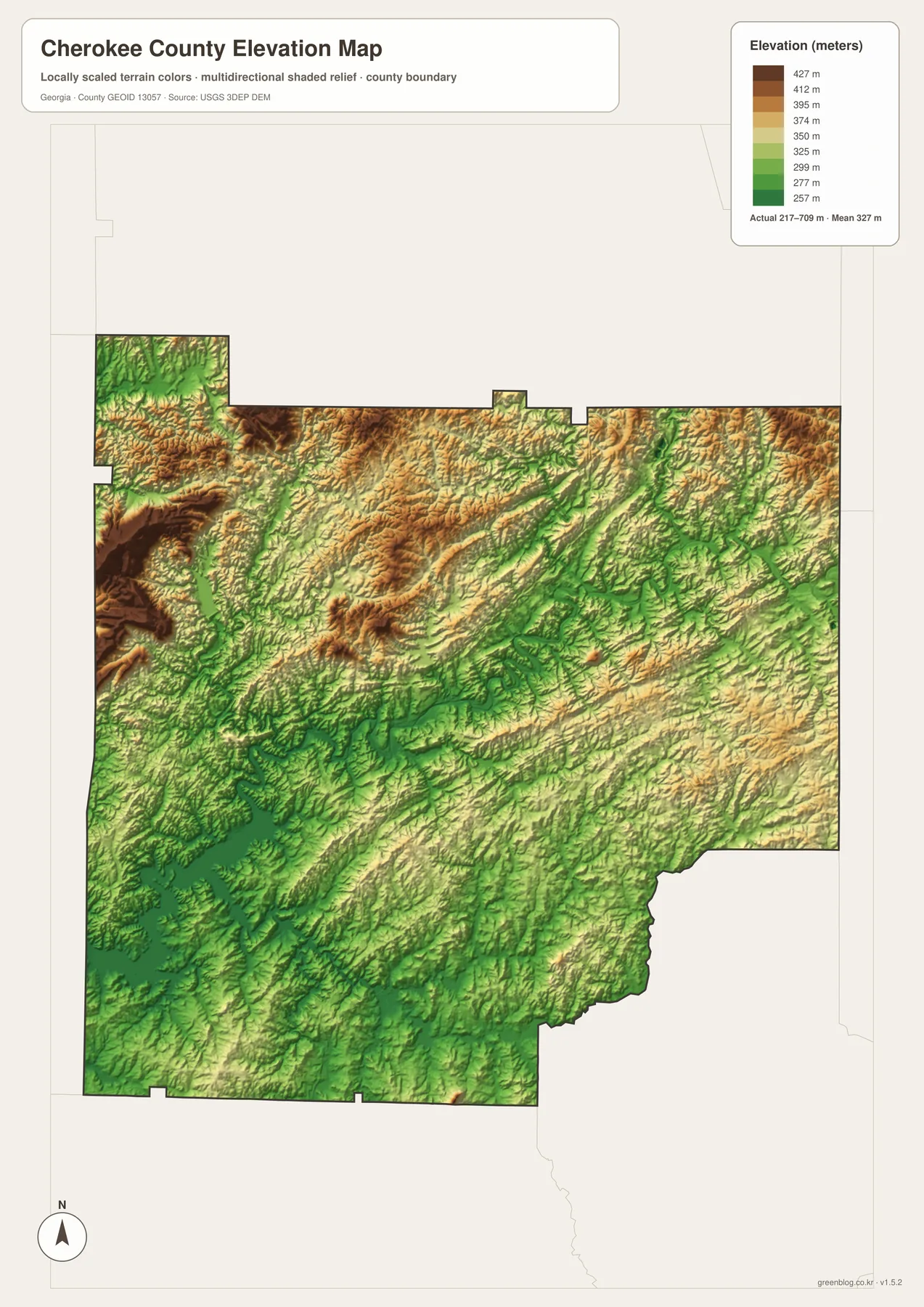
The shaded relief also makes the drainage network easier to understand. Streams occupy lower corridors between ridges, and the water map shows many of those channels joining larger creeks, the Etowah River, or Allatoona Lake. In the north, repeated ridges and valleys help explain why local roads curve more often than the main highway corridor through the developed south.
Combining the city and elevation maps reveals another useful contrast. Woodstock, Holly Springs, and Canton sit within the county’s main transportation and development corridor, while the higher northern and northwestern terrain surrounds smaller communities and less continuous development. I‑575 crosses that changing landscape efficiently, but roads away from the highway must follow the local terrain more closely.
The elevation image is intended for regional terrain comparison. It should not be treated as a site survey, engineering grade map, or exact elevation certificate for a property. USGS 3DEP data or professional survey information is the appropriate follow-up when precise site elevation or slope is required.
Quick facts to keep beside the maps
| State | Georgia |
|---|---|
| County seat | Canton |
| Created | December 1831 |
| 2020 census population | 266,620 |
| 2025 population estimate | 299,273 |
| Land area | 421.08 square miles |
| 2020 population density | 633.2 people per square mile |
| FIPS code | 13057 |
| Main roads | I‑575, SR 20, SR 92, SR 140 |
| Major waters | Etowah River, Little River, Allatoona Lake |
| Elevation-map actual range | About 217–709 m; mean about 327 m |
The statistics and maps describe two sides of the same county. Cherokee has a large and growing population, but the visual pattern is not simply one continuous suburb. Development is broadest around Woodstock, Holly Springs, Canton, and the I‑575 corridor, while lake shorelines, stream valleys, and higher northern ridges interrupt that urban pattern. The result is a county where metropolitan growth and North Georgia terrain meet within a relatively short distance.
Cherokee County was created in December 1831 from Cherokee Nation territory. The existing county history sources describe gold discovery, Georgia’s seizure of Cherokee land, and the forced removal of Cherokee people in the 1830s as part of that formation period. Canton was first known as Etowah and later grew with rail and manufacturing. Modern highway-centered development therefore sits on top of much older settlement patterns organized around the river and transportation routes.
Choosing the right map for your task
For a first look, start with the general county map and locate Canton, I‑575, and the southern county line. Move to the city map when you need the relative positions of Woodstock, Holly Springs, Canton, Ball Ground, Nelson, and Waleska. Use the water map to trace the Etowah and lake system, then open the elevation map when you want to see why streams and local roads follow valleys rather than straight lines.
- County orientation: Use the general map for the boundary, major roads, named places, and nearby communities.
- City comparison: Use the ranked city map to compare the main settlement corridor with smaller northern places.
- Water research: Follow the Etowah River, Little River, Allatoona Lake, reservoirs, and tributaries on the water map.
- Terrain context: Compare higher northern ridges with lower river and lake areas on the elevation map.
- Print or document work: Check the WEBP previews first, then use the downloadable high-resolution JPG set when you need larger source images.
Keeping the four views separate makes each one easier to read. A single crowded graphic would hide either the city labels, the water network, or the terrain detail. The downloadable set lets you choose the map that best matches the question instead of forcing every feature into one image.
Frequently Asked Questions
What is the city order along the main I‑575 corridor?
From south to north, the map places Woodstock first, then Holly Springs, then Canton. Ball Ground is farther north and northeast. Waleska is northwest of Canton rather than directly on the same highway line, and Nelson is near the northern county edge.
How do the Etowah River and Allatoona Lake connect on the map?
The Etowah River enters Cherokee County from the east, passes the Canton area, and continues southwest into Allatoona Lake. Little River and many smaller creeks feed the same broader system. The water map is useful for that geographic connection, but it is not a flood-risk or navigation map.
Where is the higher terrain in Cherokee County?
The elevation map shows the most extensive higher ridges in the northern and northwestern parts of the county. Its reported actual range is about 217 to 709 meters, with a mean near 327 meters. Lower green areas are more common along larger valleys, rivers, and the Allatoona Lake side of the county.
Map File Information
Cherokee County four-map high-resolution JPG set
- Included Files: 4 high-resolution JPG maps described on this page
- File Type: JPG files in a ZIP archive
- Intended Use: Printing, education, presentations, and map-based projects
Related Maps
Sources and reference data
- U.S. Census Bureau QuickFacts: Cherokee County, Georgia — population, area, density, and county statistics
- Georgia Department of Community Affairs: Cherokee County 2023 Comprehensive Plan — growth, transportation, and natural-resource context
- U.S. Army Corps of Engineers: Allatoona Lake — reservoir and federal management information
- USGS National Hydrography — water-feature reference data
- USGS 3D Elevation Program — elevation reference data
- U.S. Census Bureau TIGER/Line Shapefiles — county boundary and geographic reference data
These maps are designed for geographic reference and downloadable map use. Confirm parcel boundaries, flood zones, road jurisdiction, shoreline rules, and other legal or site-specific questions with the latest records from the responsible agency.
Green Map creates custom-edited map images using open geographic data sources such as geoBoundaries, Natural Earth, OpenStreetMap, and government open data. These maps are edited visual materials, not raw data files, and are provided for education, documents, presentations, and graphic reference.