Download high-resolution A3 JPG maps of Freestone County, Texas from the ZIP box on this page, including the county, city, water, and elevation views shown below. Teague and Fairfield are the most prominent settlement references, with Wortham and Kirvin grouped farther northwest. Interstate 45 and U.S. 84 make Fairfield the clearest road junction, while the water map reveals a much denser landscape of Tehuacana Creek, Cottonwood Creek, Caney Creek, Upper Keechi Creek, small lakes, and branching tributaries. The elevation surface ranges from about 56 to 182 meters, contrasting lower northern and northeastern drainage areas with higher western and southwestern hills.
The county is easiest to understand by starting with the relationship between Teague and Fairfield rather than by trying to follow every small stream at once. The city-connections map uses Teague as its hub and shows Fairfield about 9 miles away, Kirvin about 10 miles away, and Wortham about 16 miles away by direct distance. The general county map then adds highways and local roads, while the water and elevation maps show that the broad spaces between the towns are divided by many creek valleys and ridges. Those layers turn a simple four-city diagram into a much more detailed picture of the county.
Table of Contents
Fairfield, Teague, and the Main Road Network
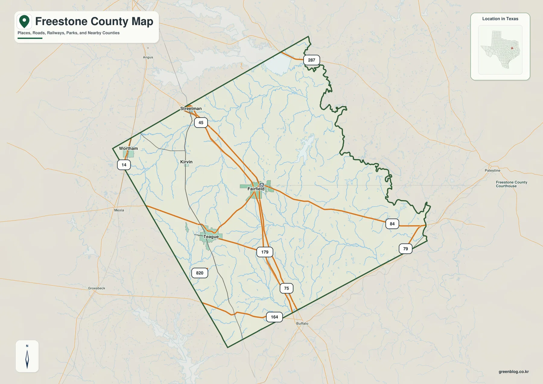
Fairfield sits near the middle of the general county map and provides the strongest road reference. Interstate 45 approaches from the northwest, passes the Fairfield area, and continues south. U.S. 84 crosses the county from the Teague side through Fairfield toward the eastern boundary. South of Fairfield, Route 75 forms another long north-south line, while Route 79 appears near the southeastern edge. Once those roads are located, the county’s central and southern layout becomes much easier to follow.
Teague lies southwest of Fairfield, with Route 179 shown between the two areas. Wortham and Kirvin are farther northwest, and Route 14 runs near Wortham along the western side. Streetman is close to the northwestern boundary, where Route 45 appears near the Interstate 45 corridor. The long northern tip of the county reaches Route 287, giving the map a very different shape from the broader central and southern sections.
Routes 164 and 820 are visible in the south and southwest, adding local connections outside the Fairfield–Teague corridor. The orange road lines are relatively easy to trace, but the blue drainage network beneath them is much more intricate. East and southeast of Fairfield in particular, many short tributaries branch through the terrain. This makes the county map useful for establishing roads and towns first before turning to the more detailed water map.
A Four-City View with Teague as the Hub
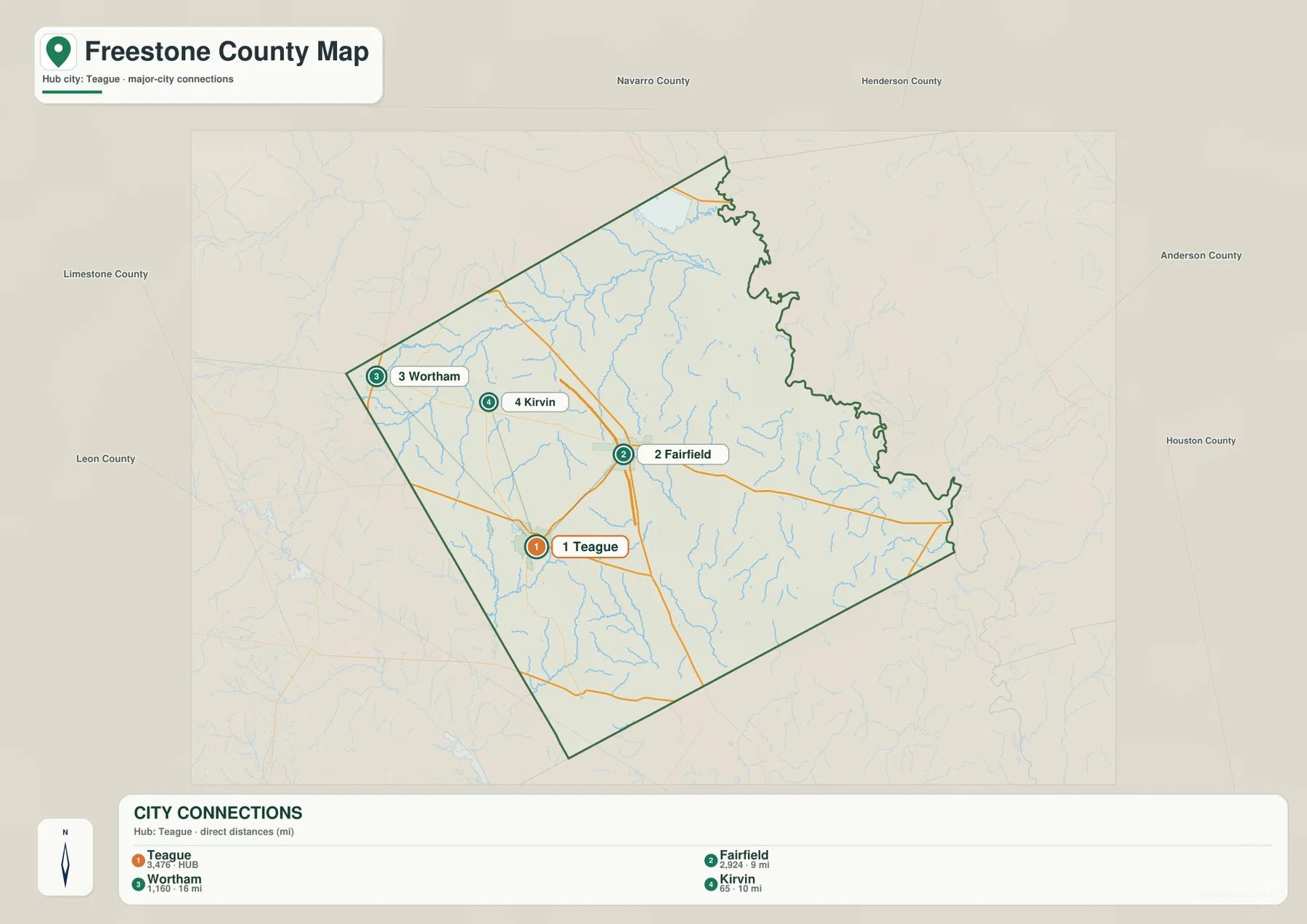
The city-connections map is built around Teague rather than Fairfield. Teague is listed first with a displayed value of 3,476 and marked as the hub. Fairfield is second at 2,924 and about 9 miles away by the map’s direct-distance measure. Wortham is third at 1,160 and about 16 miles from Teague, while Kirvin is fourth at 65 and about 10 miles away. These are the values printed on the supplied city map; the mile figures are direct distances rather than road-driving distances.
The spatial arrangement is as useful as the ranking. Teague occupies the southwest side of the four-city group, and Fairfield sits northeast of it. Wortham and Kirvin form a smaller northwest cluster, with Wortham closer to the western boundary and Kirvin farther east. The map therefore does not show one compact urban center. It shows a close Teague–Fairfield pair and two smaller communities separated toward the northwest.
Switching back to the county map adds the transportation context that the city graphic intentionally leaves out. The short direct connection between Teague and Fairfield corresponds to a road system involving Route 179 and the U.S. 84 corridor, while Wortham and Kirvin sit among different local roads and creek valleys. The city view is best for comparing rank, direction, and direct spacing; the general map is better for understanding how those communities are actually connected through the county.
Tehuacana, Caney, and Upper Keechi Creek Valleys
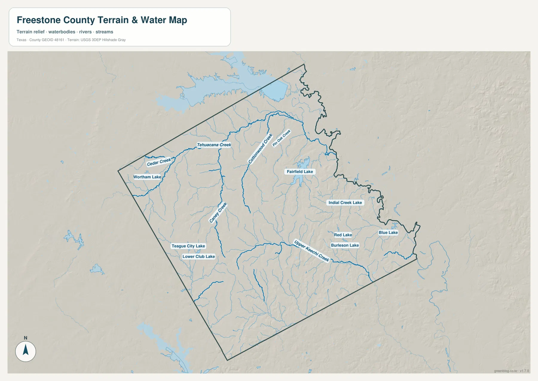
Tehuacana Creek is one of the strongest water references in the northwest. Cedar Creek enters the same general drainage area, and Wortham Lake is labeled close to the western side. Farther east, Cottonwood Creek and Pin Oak Creek cut through the north-central terrain. Fairfield Lake lies east-northeast of Fairfield, surrounded by smaller tributaries that extend toward the lower northeastern edge of the county.
The Teague area has its own set of water features. Teague City Lake and Lower Club Lake are both labeled nearby, while Caney Creek runs through a long valley farther east. In the southeastern half, Upper Keechi Creek becomes a major named channel. Red Lake and Burleson Lake sit near that drainage, with Indian Creek Lake and Blue Lake farther toward the eastern boundary. The map shows a county filled with separate creek systems rather than one dominant river channel.
A useful way to read the water map is to begin with the boldest named creeks and then add the nearby lakes. Tehuacana Creek organizes much of the northwest, Cottonwood and Caney Creek help divide the central interior, and Upper Keechi Creek provides a strong reference across the southeast. Numerous smaller tributaries branch between them, especially through the lower eastern terrain.
This is a location and terrain reference, not a flood map or a legal shoreline product. It does not establish water depth, year-round stream flow, navigability, or flood risk. Those questions require separate official data. For county-scale reading, however, the map clearly shows how much of the space between Teague, Fairfield, Wortham, and Kirvin is shaped by creek valleys and small reservoirs.
Lower Northeast Drainage and Higher Western-Southwestern Hills
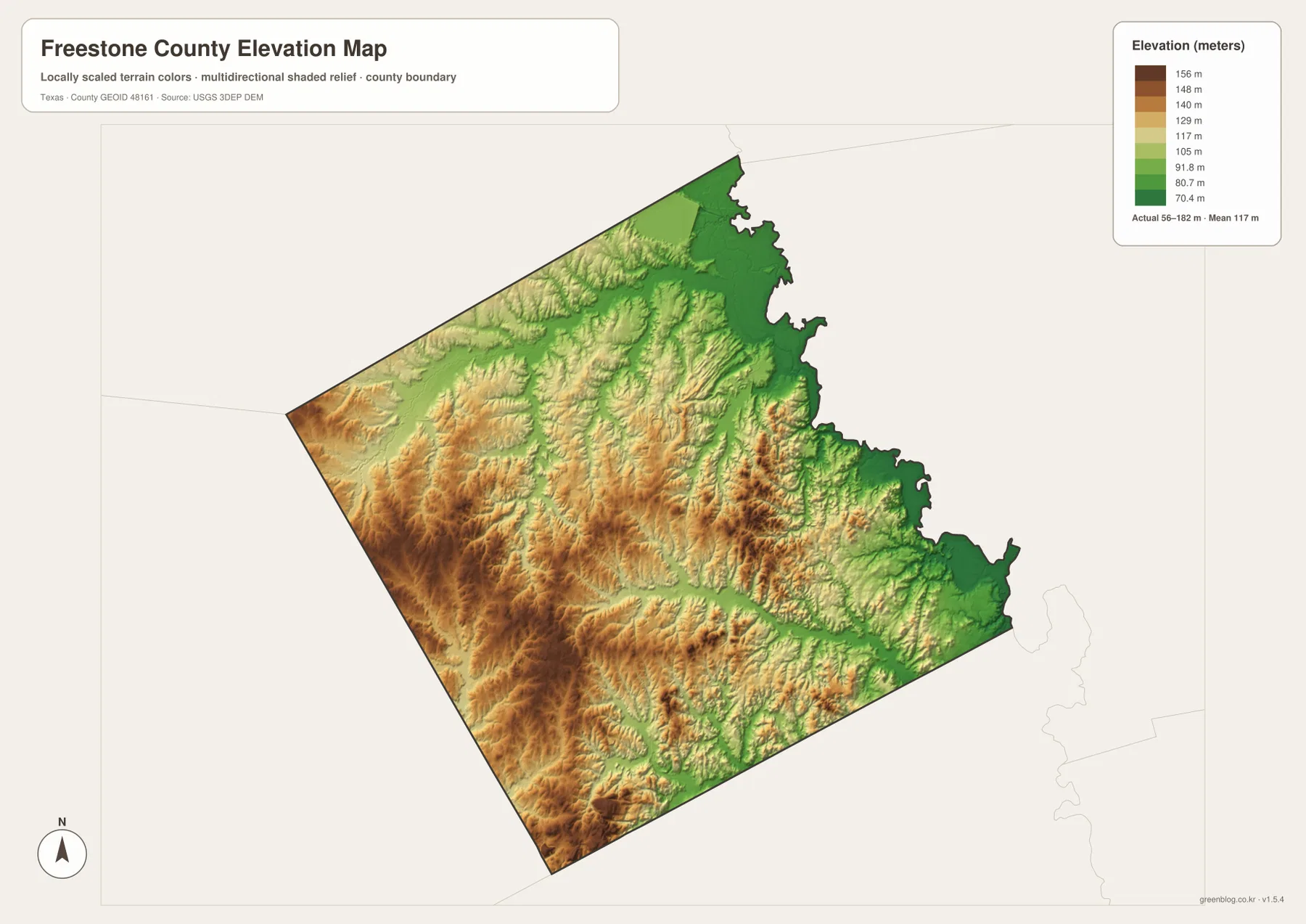
The elevation map lists an actual county range of about 56 to 182 meters and a mean near 117 meters. Green colors dominate much of the north and northeast, indicating broad lower terrain associated with the drainage network. Higher tan and brown surfaces become more widespread toward the west and southwest. Long ridges also extend through the interior, giving the county more relief than a road-only map suggests.
The pattern is not a simple smooth slope from one corner to another. Creek valleys repeatedly cut through the higher ground, leaving narrow green and light-green corridors between ridges. Tehuacana Creek occupies one such lower path in the northwest, while Upper Keechi Creek and its tributaries create lower channels through the southeast. Small elevated ridges also remain in the central and eastern interior, so the terrain alternates frequently between local highs and drainage lows.
The southwest contains some of the strongest brown relief on the map, while the far northeast has the broadest continuous low area. Around Wortham and Kirvin, higher and lower surfaces are mixed because creek valleys dissect the uplands. Around Teague, the terrain rises toward the west and south but drops along nearby drainage lines. This helps explain why the water network and the elevation surface should be read together rather than treating the county as uniformly rolling ground.
The locally scaled color ramp is intended for comparing broad county terrain, not for determining the exact elevation of a parcel, road grade, or construction site. Even so, the 56-to-182-meter range gives enough contrast to show the difference between low drainage country and the more strongly rolling western and southwestern uplands.
How the Landscape Changes Around Fairfield and Teague
Fairfield and Teague are only about 9 miles apart on the supplied city-connections map, yet their surroundings provide a useful example of the county’s local variation. Fairfield is tied to the I-45 and U.S. 84 road junction and sits among streams that branch toward several directions. Teague lies southwest near Teague City Lake and Lower Club Lake, with stronger upland relief developing to the west and south.
Moving northwest from the Teague–Fairfield pair leads toward Wortham and Kirvin and the Tehuacana Creek–Cedar Creek drainage. Moving east from Fairfield brings the U.S. 84 corridor into an area with more tributaries, while the southeast is organized around Upper Keechi Creek and several lakes. The city map makes the four settlements look simple; the water and elevation views explain why the land between them is not.
Choosing the Best Freestone County Map for the Task
Use the general county map for Fairfield, Teague, Wortham, Kirvin, Interstate 45, U.S. 84, and the other numbered roads. The city-connections map is the quickest way to compare the four highlighted communities, their ranking, and the direct distances from Teague. The water map is more useful for Tehuacana Creek, Fairfield Lake, Caney Creek, Upper Keechi Creek, and the smaller named lakes. Choose the elevation view when you want to compare the low northeastern drainage country with the higher western and southwestern hills.
The WebP images are convenient for on-page viewing, while the ZIP below contains the matching high-resolution A3 JPG originals for printing and larger displays. The archive includes the county, city, water, and elevation maps shown here, so you can keep the complete set or use only the file needed for classroom work, a presentation, local reference, or a personal project.
Frequently Asked Questions
Which city is the hub on the supplied Freestone County city map?
Teague is the hub. The map shows Fairfield about 9 miles away, Kirvin about 10 miles away, and Wortham about 16 miles away by direct distance. Those figures are not the same as driving distances on the road network.
Which waterways are useful reference points in Freestone County?
Tehuacana Creek in the northwest, Cottonwood and Caney Creek through the interior, and Upper Keechi Creek in the southeast are strong named references. Fairfield Lake, Teague City Lake, Wortham Lake, Indian Creek Lake, and several smaller lakes provide additional landmarks.
Where are the lower and higher parts of the county on the elevation map?
Lower terrain is broadest across the north and northeast, while higher hills are more extensive in the west and southwest. The supplied elevation map lists an actual range of about 56 to 182 meters and a mean near 117 meters.
Sources and Reference Data
USGS The National Map Viewer — Official map service for roads, hydrography, terrain, and other geographic layers.
USGS National Hydrography — Official reference for rivers, creeks, lakes, and hydrographic data.
USGS 3D Elevation Program — U.S. Geological Survey program for elevation and terrain data.
U.S. Census Bureau TIGER/Line Shapefiles — Official source for county boundaries, roads, and related base geography.
Map File Information
Download the Freestone County county map, city map, water map, and elevation map as high-resolution A3 JPG files. The ZIP contains the original map files shown on this page.
- File Type: JPG
Related Maps
- Anderson County Texas map
- Navarro County Texas map
- Smith County Texas map
- Van Zandt County Texas map
- Robertson County Texas map
Green Map creates custom-edited map images using open geographic data sources such as geoBoundaries, Natural Earth, OpenStreetMap, and government open data.
These maps are edited visual materials, not raw data files, and are provided for education, documents, presentations, and graphic reference.