Paulding County lies northwest of Atlanta, with Dallas near the middle of the county and Hiram forming another visible concentration of roads and developed land to the east. You can download all four high-resolution A3 JPG map files together as one ZIP from the map file box below. The set separates the county boundary and numbered highways, the relative positions of Dallas, Hiram, and Braswell, named creeks and lakes, and the county’s rolling elevation so each feature is easier to examine without crowding everything onto one image.
The maps show a county with a clear settlement core but a much more intricate natural landscape around it. Dallas and Hiram stand out because roads and developed areas converge there, while much of the north, west, and south is crossed by small streams and short ridges. The elevation map reinforces that contrast: the west and southwest are generally higher, and greener low corridors cut through the center and east where many creeks run. Looking at the maps side by side makes Paulding County easier to understand than relying on city labels alone.
These are reference maps rather than parcel, flood, engineering, or turn-by-turn navigation products. Major roads and selected places are shown to help with orientation, while the water and elevation maps simplify the landscape so county-wide patterns remain readable. The sections below focus on what is actually visible in the supplied maps and explain where each one is most useful.
Table of Contents
Dallas anchors the road network inside the county boundary
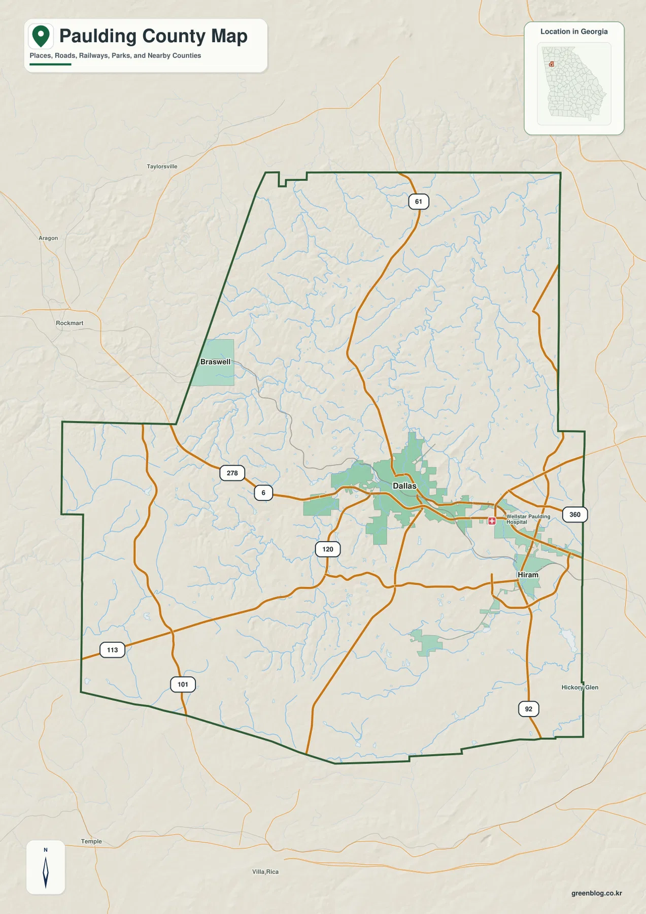
Dallas is the strongest visual center on the county map. A broad developed area surrounds the county seat, and the road network spreads from that central zone toward Hiram, the county’s other prominent developed area to the east. Braswell appears much farther northwest near the county edge and occupies a smaller footprint. This makes the map useful for understanding that Paulding County’s named cities are not evenly spaced or equal in size: two are closely tied to the central-eastern road system, while Braswell sits apart from it.
Several numbered roads give the map a practical frame of reference. Routes labeled 278 and 6 approach Dallas from the west along the same general east-west corridor. Route 61 comes down from the north, Route 120 crosses the area south and west of Dallas, and Route 360 continues toward the Hiram side of the county. Route 92 is marked farther southeast, while 113 and 101 provide additional reference points in the western and southwestern part of the county. Together they show that Dallas is connected from several directions rather than by a single through road.
Wellstar Paulding Hospital is also marked east of Dallas along the developed corridor toward Hiram. That label is useful because it adds a real-world destination between the two urban areas instead of leaving the map as an abstract network of lines. Smaller neighborhood streets are intentionally not shown at the same level of detail, so the map works best for county orientation, regional context, and identifying the main road framework rather than planning a precise driving route.
Hiram is close to Dallas; Braswell sits apart in the northwest
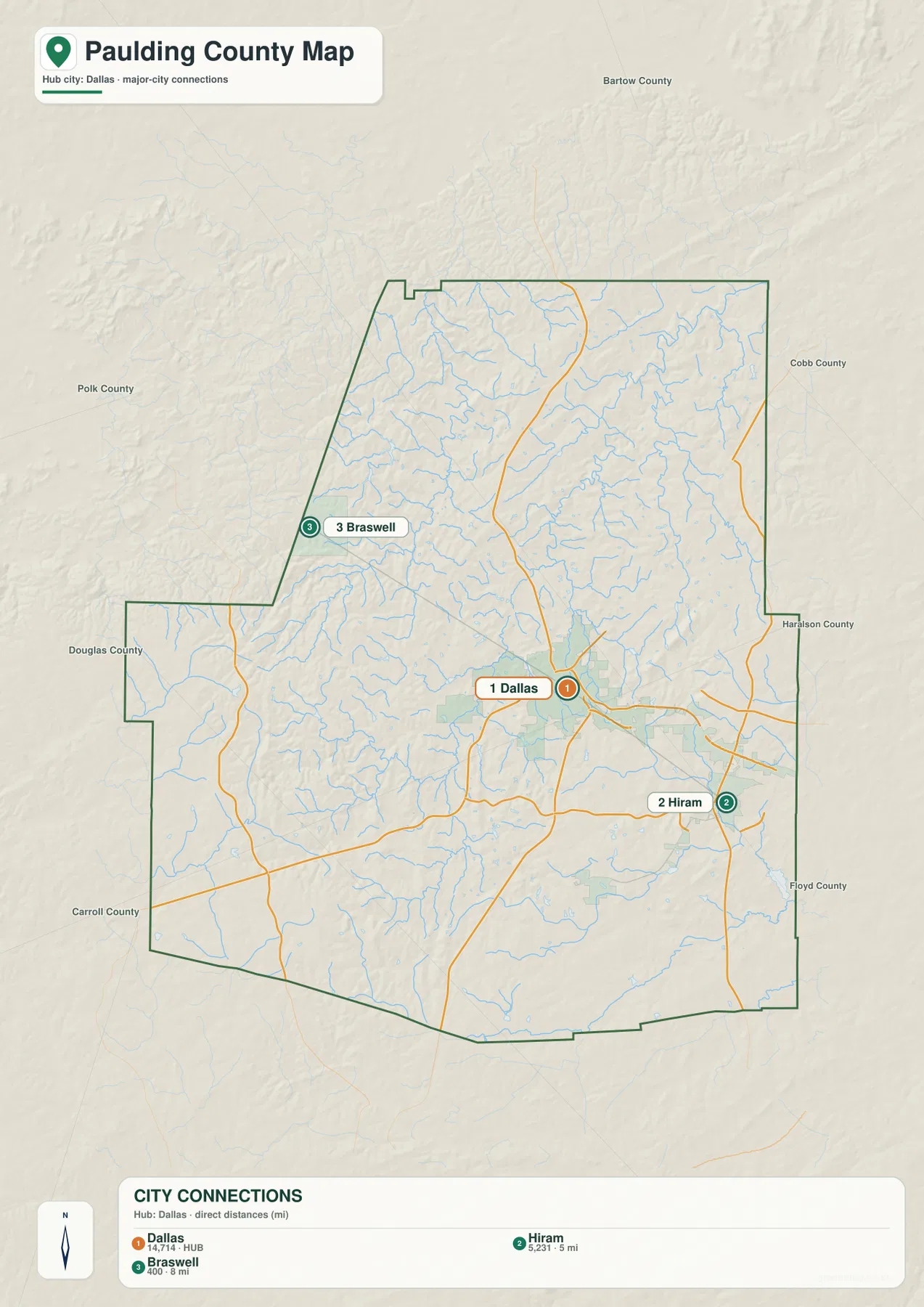
The city-connections map reduces the county to three labeled places so their relative positions are immediately clear. Dallas is the hub. Hiram lies southeast of it and is labeled about 5 miles away, while Braswell lies northwest and is labeled about 8 miles from Dallas. Those distances are straight-line measurements between the mapped points, not road mileage. A drive between the cities can be longer because roads follow the terrain and do not necessarily take the shortest geometric path.
The difference between Hiram and Braswell becomes more meaningful when this map is compared with the county-road map. Dallas and Hiram are close enough that their developed areas and major road connections appear as part of one broader central-eastern cluster. Braswell is separated from that cluster by a large stretch of creek-cut countryside. The city map therefore helps answer a simple but important question: which places belong to the same visible settlement corridor, and which places sit farther away within the same county?
County names around the outside of the city map provide additional location context, including Bartow to the north, Cobb to the east, and Polk, Douglas, and Carroll on other sides of the mapped area. The exact purpose of this map is still local orientation rather than a complete boundary atlas, but those labels make it easier to place Paulding County in the northwestern part of the Atlanta region. They also show why Dallas can function as a county hub while Hiram remains an important eastern reference point closer to the metropolitan side.
Creeks divide the county into short ridges and narrow valleys
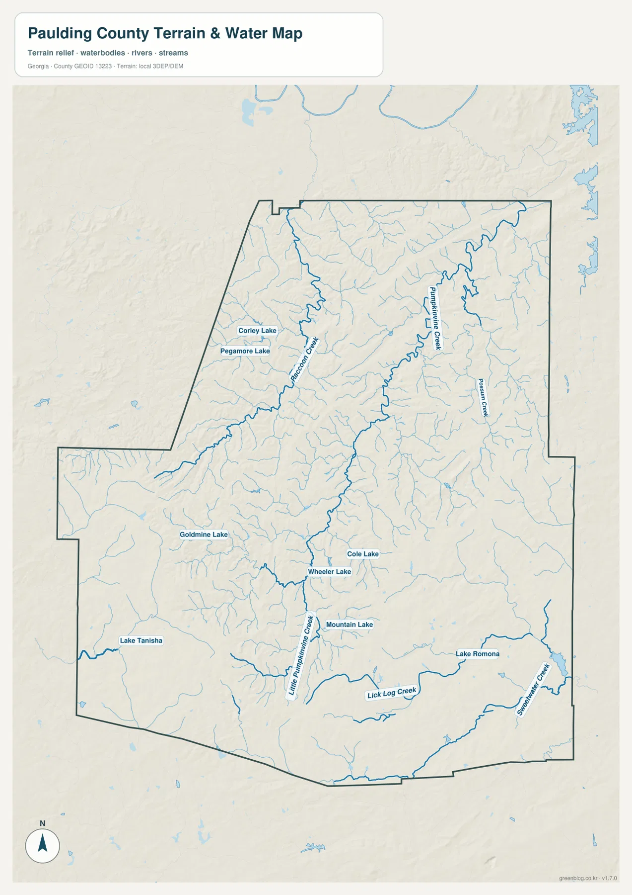
The water map looks very different from the road map because blue stream lines cover almost the entire county. Pumpkinvine Creek is one of the clearest named channels in the northern and central portion. Raccoon Creek winds through the northwest, Possum Creek is labeled in the east, and Little Pumpkinvine Creek continues through the southern half. Farther south and southeast, Lick Log Creek and Sweetwater Creek provide additional named reference lines. Numerous unnamed tributaries branch into these larger creeks, showing how thoroughly the county is dissected by small valleys.
Several lakes provide useful local anchors. Corley Lake and Pegamore Lake are shown in the northwest, Goldmine Lake and Lake Tanisha appear in the southwest, and Cole Lake, Wheeler Lake, and Mountain Lake sit closer to the central-southern area. Lake Romona is labeled farther southeast. The map does not imply that these water bodies have the same size, access, or purpose; it simply uses named features that help readers locate different parts of the county.
Relief shading behind the streams is important. Many creek lines follow lower ground between short, branching ridges, so the map explains why the county’s natural surface feels much more complex than the simplified road network suggests. A creek may appear to run almost parallel to a nearby ridge before turning sharply into another valley. This relationship is useful for geographic study, but the map should not be treated as a flood-hazard map, a property-boundary source, or a navigation chart. For those purposes, an official product designed for the specific question is necessary.
Higher ground dominates the west and southwest
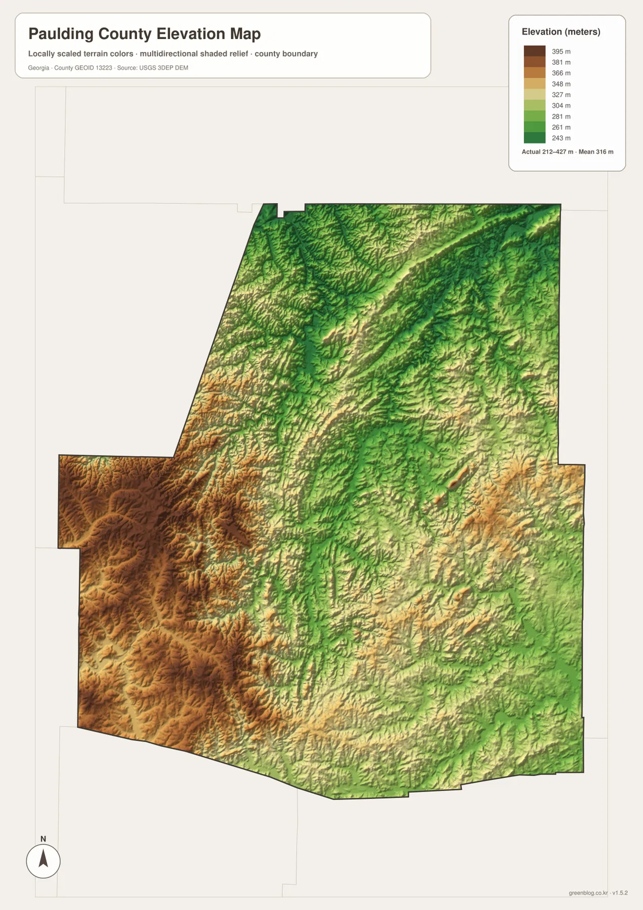
The elevation map shows an actual mapped range of about 212 to 427 meters, with a mean near 316 meters. Brown and orange terrain is concentrated across much of the west and southwest, while greener lower corridors occupy parts of the center, east, and northeast. The contrast is not a single mountain beside a flat plain. Instead, Paulding County is made up of many ridges and valleys, with some broad areas standing higher than others and countless smaller changes visible in the shaded relief.
The western and southwestern high ground is especially clear because it forms a relatively large connected area. Moving toward the middle of the county, the colors become more mixed as ridges alternate with lower drainage corridors. In the north and northeast, long green channels cut between narrower ridges. Comparing these shapes with the water map shows why so many stream branches occupy the same lower bands: the creeks follow the valleys while the higher ground separates one drainage line from the next.
This is a county-scale elevation surface, not a survey-grade measurement for a house lot, road project, or engineering design. Its value is comparative. It answers questions such as whether the western side is generally higher than the central creek valleys, where long low corridors cross the county, and why some roads bend around rougher terrain. For precise elevations at a specific point, a dedicated survey or authoritative site-level dataset would be required.
Putting roads, settlements, water, and relief together
The strongest lesson from the four maps is that Paulding County has a concentrated human geography set inside a much finer natural pattern. Dallas sits where several major roads meet, and Hiram is close enough to share the same broader eastern development corridor. Away from that area, the county becomes a web of creek valleys and ridges. Braswell’s northwestern position makes this contrast particularly easy to see because it lies far from the central-eastern concentration even though its straight-line distance from Dallas is only about eight miles.
For questions about where the cities and main routes are, the county and city maps should be the first stop. For questions about natural drainage and terrain, the water and elevation maps are more informative. Raccoon Creek, Pumpkinvine Creek, and Sweetwater Creek can be traced against the lower valleys, while the elevation map highlights the higher western and southwestern ridges between them. Switching between the map types is more useful than trying to force all of those details into one crowded image.
Paulding County was established in 1832 according to the existing county reference material supplied with this package. The same background material notes suburban housing, commuting, roads, and the Silver Comet Trail as important parts of the county’s modern setting. The maps here are not a trail guide or a complete transportation inventory, but they do provide the geographic frame for that context: Dallas and Hiram sit in the road-focused core, while broad parts of the county remain shaped by rolling terrain and a dense stream network.
Frequently Asked Questions
Are the 5-mile and 8-mile city distances driving distances?
No. The city-connections map measures straight-line distance from Dallas to the mapped point for each city. Hiram is labeled at about 5 miles and Braswell at about 8 miles from the Dallas hub. Road mileage can be longer because the actual route must follow the road network and the rolling terrain.
What stands out most on the Paulding County elevation map?
The west and southwest contain the broadest areas of higher ground, while many central and eastern creek corridors appear lower. The supplied elevation map shows an actual county range of roughly 212 to 427 meters and a mean around 316 meters. It is designed for county-wide comparison, not site-specific surveying or engineering.
Can the terrain-and-water map be used to determine flood risk?
No. It is a reference map for locating streams, lakes, and terrain. Features such as Pumpkinvine Creek, Raccoon Creek, Sweetwater Creek, and several named lakes are shown, but the map does not contain flood zones, parcel boundaries, legal water limits, or navigation information. An official flood or property product is needed for those decisions.
Sources and reference data
- Paulding County government history page
- U.S. Census Bureau QuickFacts for Paulding County
- New Georgia Encyclopedia: Paulding County
- USGS National Hydrography
- USGS 3D Elevation Program
Map File Information
The WEBP images in the article are lightweight previews. The download ZIP contains four original high-resolution A3 JPG files for Paulding County: the county map, city-connections map, terrain-and-water map, and elevation map.
- File Type: Four JPG files in one ZIP archive
Related Maps
Green Map creates custom-edited map images using open geographic data sources such as geoBoundaries, Natural Earth, OpenStreetMap, and government open data. These maps are edited visual materials, not raw data files, and are provided for education, documents, presentations, and graphic reference.