Morrison County is organized around one unmistakable geographic feature: the Mississippi River running through Little Falls. The general map shows U.S. 10 and Minnesota 371 meeting the Little Falls area, with Royalton to the south, Pierz to the east, and Randall and Motley farther northwest. This guide connects that road pattern with the county’s tributaries and relief instead of treating each map as a separate list. After using the WebP previews on the page, you can download the four matching high-resolution JPG maps together in a ZIP.
Little Falls is the easiest place to begin because roads, settlement, and the river all meet there. U.S. 10 continues south toward Royalton, Minnesota 371 heads north toward Fort Ripley, and the eastern road network branches toward Pierz. The Mississippi then provides a natural reference through the middle of the county, while tributaries approach from both west and east. Once that central river valley is clear, the higher northwest and eastern terrain on the elevation map becomes much easier to place.
Table of Contents
Little Falls as the Road and River Reference Point
The county overview makes Little Falls the most visually concentrated road and settlement center. U.S. 10 passes through the city and continues south toward Royalton, while Minnesota 371 runs north on the route toward Fort Ripley and the Brainerd area. Randall lies northwest of Little Falls on a separate road connection, and the southwestern communities around Upsala and Elmdale are reached by a different set of roads. Morrison County therefore does not have one simple highway corridor serving every major community.
Pierz provides a second strong reference on the eastern side. Minnesota 27 crosses the Pierz area, and Minnesota 25 runs south through Buckman. Harding and Hillman appear farther north and east, showing that the eastern half contains several scattered settlement points rather than one continuous built-up strip. Reading the Little Falls road network separately from the Pierz side is a useful way to make sense of the county before looking at the waterways.
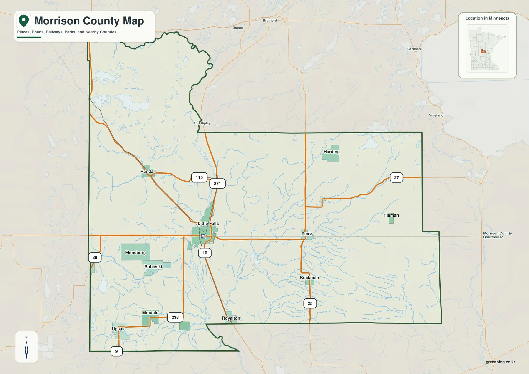
The county outline is also distinctive. A northern section reaches toward Motley and Fort Ripley, the southern boundary bends around the Royalton area, and the southwest extends toward Upsala. Those irregular edges matter when judging whether a nearby road or town is still inside Morrison County. The overview is useful for orientation, but parcel lines and legal property boundaries should be checked with Morrison County’s official mapping tools or survey records.
Six Communities Spread from Royalton to Motley and Upsala
The ranked city distribution map highlights six major communities. Its index lists Little Falls at 9,121, Royalton at 2,117, Pierz at 1,424, Randall at 695, Motley at 608, and Upsala at 417. Little Falls is clearly the largest entry on the map, but the remaining communities are spread widely across the county rather than forming a tight suburban ring around it.
Royalton has the clearest north–south relationship with Little Falls because both are associated with the U.S. 10 and Mississippi River corridor. Pierz sits well to the east, while Randall is northwest of Little Falls. Motley is farther toward the county’s northwestern end, and Upsala is near the southwest. The simplified city map makes those relative positions easier to compare than the road-heavy overview.
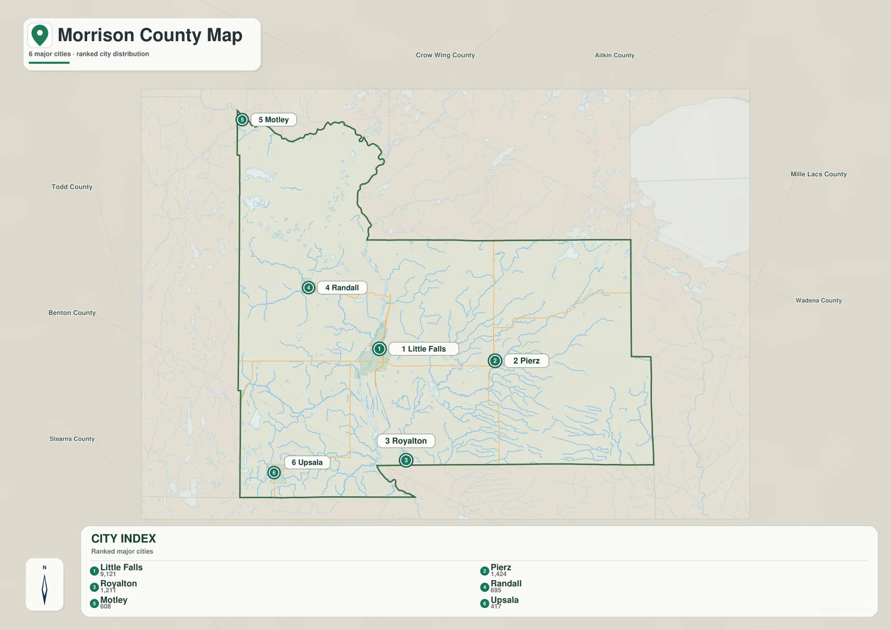
That separation is important when using the city index. A lower-ranked community can still be geographically important because it anchors a distant part of the county. Motley and Upsala are good examples: both are far from the central Little Falls cluster and help define the reach of the county in opposite directions. The index values should be treated as the figures supplied with this map; current official population estimates should be checked against the latest U.S. Census Bureau data when needed.
Tributaries Converging on the Mississippi River Corridor
The Mississippi River is the organizing waterway on the terrain and water map. It enters from the north, passes through the Little Falls area, and continues south, receiving tributaries from both sides. From the west, the Little Elk River trends southeast toward the central river corridor. Farther south, the Swan River, Little Two River, and N Two River cross the western part of the county and move toward the Mississippi system.
The eastern drainage is just as distinctive. The Platte River approaches from the northeast and bends toward the center, while the Skunk River follows a winding path across the eastern half. Buckman Creek appears farther south as another tributary route. These named streams make the eastern side look much more dissected on the water map than it does on the general road map, where the smaller channels are less prominent.
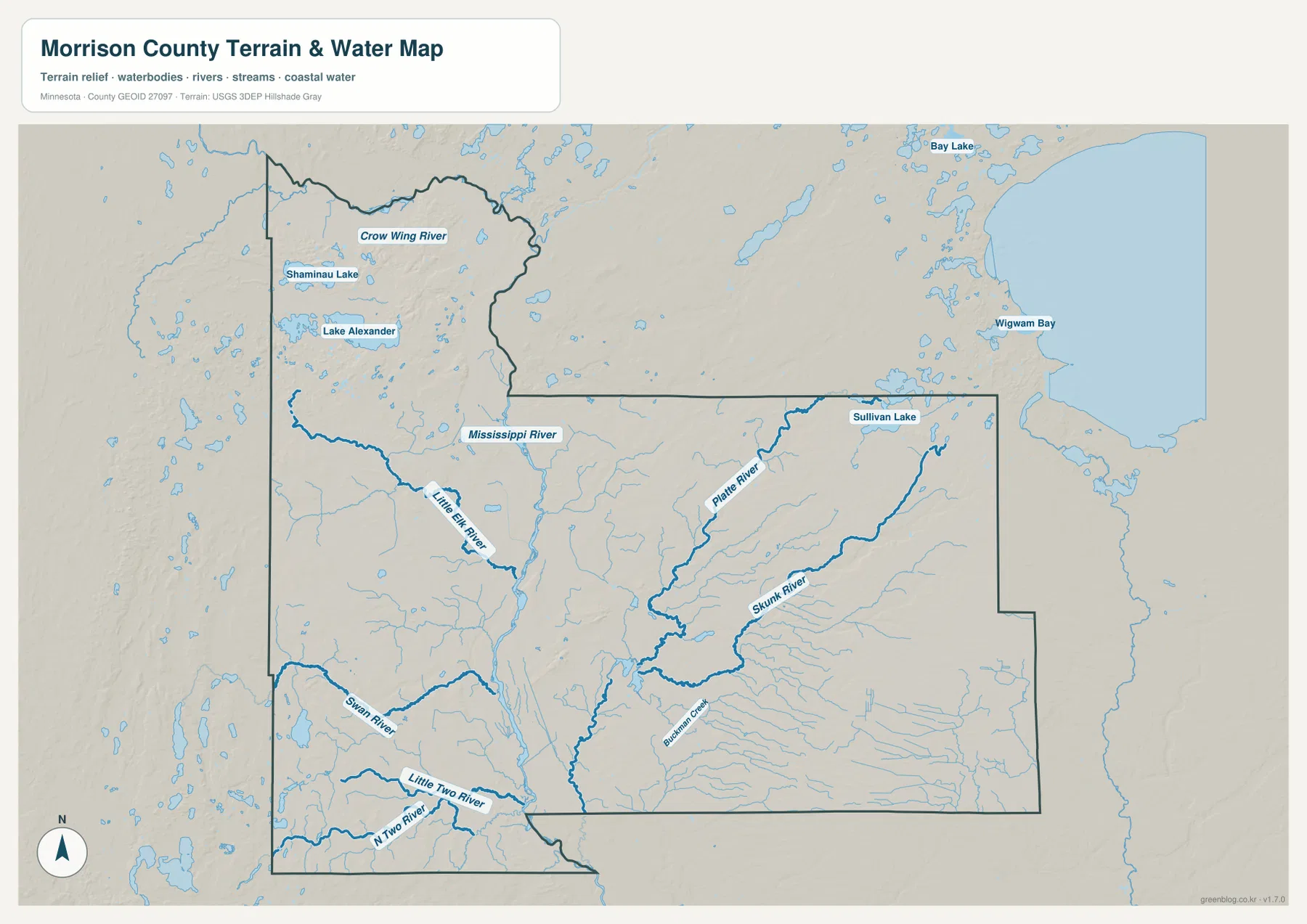
Several lakes provide additional landmarks. Shamina Lake and Lake Alexander are labeled in the northwest, and Sullivan Lake appears in the northeast. The map also shows the huge Mille Lacs Lake just outside the county to the east, including Wigwam Bay, which helps place Morrison County immediately west of that major lake region. The Crow Wing River is visible near the northern edge, adding another large river reference close to the county’s upper boundary.
The water layer is for geographic reference, not flood, depth, navigation, shoreline ownership, or legal-access decisions. Near Little Falls, Charles A. Lindbergh State Park provides a useful county-specific example of the river landscape: Minnesota DNR describes Pike Creek crossing the park and emptying into the Mississippi River, with river and creek recreation available there. Current DNR and local guidance should be used for boating, fishing, access, and safety questions.
A Low Mississippi Valley between Higher Northwest and Eastern Ground
The elevation map shows a low central corridor aligned with the Mississippi River. Its legend gives an actual range of about 311 to 464 meters and a mean near 372 meters. Greens dominate much of the river valley through the middle and south-central county, while yellows, oranges, and browns become more common toward the northwest and east. Little Falls sits close to the transition between the low river corridor and higher surrounding land.
The northwest contains some of the sharpest local relief. Around the Motley and Lake Alexander side, long ridges and irregular hills rise above lower valleys, creating a much rougher surface than the central Mississippi corridor. Moving toward the river, the colors become greener and the land drops. This helps explain why several western tributaries descend toward the center rather than continuing across the county at the same elevation.
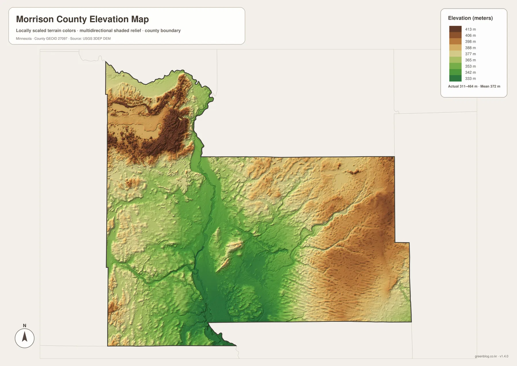
Eastern Morrison County is also higher than the central river valley. Brown and orange terrain is widespread east and southeast of Pierz, while lower lines follow parts of the Platte and Skunk river systems. The county is therefore better described as a low Mississippi corridor between higher areas than as a simple slope from north to south. That distinction is one of the clearest features visible when the elevation and water maps are viewed together.
The elevation colors are locally scaled to emphasize variation inside Morrison County. A particular green or brown shade should not be assumed to represent the same height on another county map. The shaded surface is also intended for broad geographic interpretation, not engineering or survey work. Construction, drainage design, legal elevation questions, and site-level decisions require more precise source data or field measurements.
Choosing the Best View for Roads, Towns, Rivers, or Relief
For road orientation, start with the county overview. It is the best map for seeing how U.S. 10, Minnesota 371, Minnesota 27, and Minnesota 25 relate to Little Falls, Royalton, Pierz, Randall, and the surrounding communities. If the task is simply to compare the six highlighted cities, the ranked distribution map removes much of that road detail and makes the separation between Little Falls, Motley, and Upsala especially clear.
For natural features, use the Mississippi River as the anchor. The water map shows the Little Elk, Swan, Little Two, Platte, and Skunk rivers approaching the central corridor from different directions. The elevation map then explains the setting: the Mississippi occupies a broad lower zone, with higher ground rising in the northwest and east. That pairing gives more context than either map can provide on its own.
The page previews use WebP files for quick viewing, while the downloadable archive contains the original high-resolution JPG versions. Each map is 3638 by 2572 pixels, making the originals more useful for printing or zooming into smaller river names and road labels than a browser screenshot. The archive includes the county overview, ranked city distribution, water and terrain map, and elevation map.
A practical sequence is to begin at Little Falls, follow the Mississippi south toward Royalton, then look east toward Pierz and the Platte–Skunk river network. After that, move northwest toward Randall, Motley, Lake Alexander, and the higher ridges. This route through the maps mirrors the county’s strongest geographic contrast: a central river valley linking widely separated communities while higher terrain rises on both sides.
Frequently Asked Questions
Which map is best for locating Little Falls and the Mississippi River?
Start with the county overview to place Little Falls, U.S. 10, Minnesota 371, and Royalton. Then use the water map to follow the Mississippi River and see how the Little Elk, Platte, Skunk, Swan, and Little Two rivers connect with the central corridor. Together they provide both road and river context.
Where is the higher terrain in Morrison County?
The elevation map shows the Mississippi River corridor as a lower central zone, while the northwest and much of the eastern side are higher. The actual range shown in the legend is about 311–464 meters with a mean near 372 meters. The Motley–Lake Alexander area and land east of Pierz contain some of the strongest brown and orange relief.
How are the six highlighted cities distributed across the county?
Little Falls is near the central river corridor, Royalton is south, and Pierz is east. Randall lies northwest of Little Falls, Motley is farther toward the northwestern end, and Upsala is near the southwest. The city map is best for comparing those relative positions, while the county overview adds the roads that connect them.
Map File Information
The ZIP contains the original high-resolution JPG versions of the Morrison County overview, city distribution, water, and elevation maps.
- File Type: ZIP containing 4 JPG files
Related Maps
Sources and References
- Morrison County official website – county government and online mapping information
- Minnesota DNR Charles A. Lindbergh State Park – Little Falls river and Pike Creek context
- U.S. Census Bureau TIGER/Line Shapefiles – county boundary and geographic reference data
- USGS National Hydrography – river, stream, and lake reference data
- USGS 3D Elevation Program – elevation reference data
Green Map creates custom-edited map images using open geographic data sources such as geoBoundaries, Natural Earth, OpenStreetMap, and government open data. These maps are edited visual materials, not raw data files, and are provided for education, documents, presentations, and graphic reference.