Oglethorpe County in northeastern Georgia is easier to understand when its towns, roads, streams, and relief are viewed together. Lexington and Crawford sit close to one another in the west-central part of the county, while Arnoldsville lies to the northwest and Maxeys is farther southwest. Route numbers 78 and 10 share an important east-west corridor through Crawford and Lexington, with 22 and 77 extending toward the southern half. Farther east, the Broad River and its tributaries become stronger geographic reference points than the small incorporated places.
This page separates those features into four maps so each one remains readable. The county reference map is best for the boundary, towns, major roads, and general orientation; a city-connections map compares the four labeled towns; the water map brings the Broad, Oconee, and smaller streams forward; and the elevation view shows how the higher western ridges descend into lower river and creek valleys. The page uses lightweight WEBP previews, while the download package contains four original high-resolution A3 JPG files in one ZIP for printing or offline reference.
Table of Contents
Lexington and Crawford anchor the west-central corridor
The main county map places Lexington and Crawford close together near the west-central side of Oglethorpe County. Lexington is the county seat, while Crawford is the nearest of the other labeled municipalities. Arnoldsville appears farther northwest and Maxeys is separated to the southwest. That arrangement leaves a large eastern portion of the county without an incorporated-city label of similar prominence, so roads and waterways become especially useful for understanding locations beyond the town cluster.
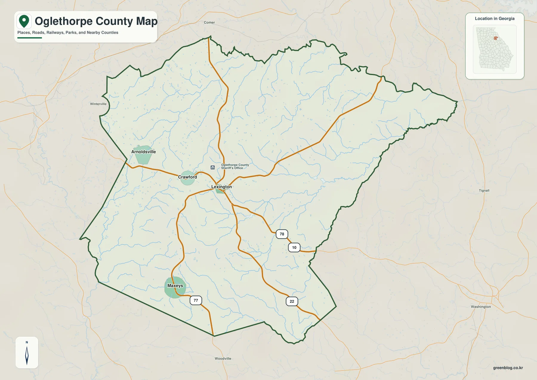
The road layer gives that town pattern a clearer structure. Routes 78 and 10 are shown together through Crawford and Lexington before continuing east. Route 22 leaves the Lexington area toward the southeast, while Route 77 passes near Maxeys and continues toward the southern boundary. Other roads head north from the central corridor, but the numbered routes are the easiest landmarks to follow at county scale. If you need to explain where a place lies without showing every local street, these roads provide a useful framework without turning the page into a navigation map.
Names around the outside include Clarke, Oconee, Greene, Madison, Elbert, Wilkes, and Taliaferro counties. Their placement helps show how Oglethorpe County fits into the surrounding part of Georgia, but the map is not intended to define individual property lines or every municipal boundary. Small roads, private drives, parcels, and many unincorporated communities are outside the purpose of this overview. The strongest use of the county map is simple orientation: start with the boundary, locate Lexington and Crawford, then follow the major road or stream nearest the area you are trying to describe.
The city diagram uses Crawford as its hub, not its county seat
The city-connections graphic makes a useful distinction that can be missed on the general map. Crawford is marked as the hub for the diagram even though Lexington is the county seat. The hub label is a cartographic choice for comparing the four mapped towns, not an administrative title. From Crawford, Lexington is shown about 3 miles away, Arnoldsville about 4 miles away, and Maxeys about 9 miles away. Those values make the relative spacing easy to grasp before you look back at the road network.
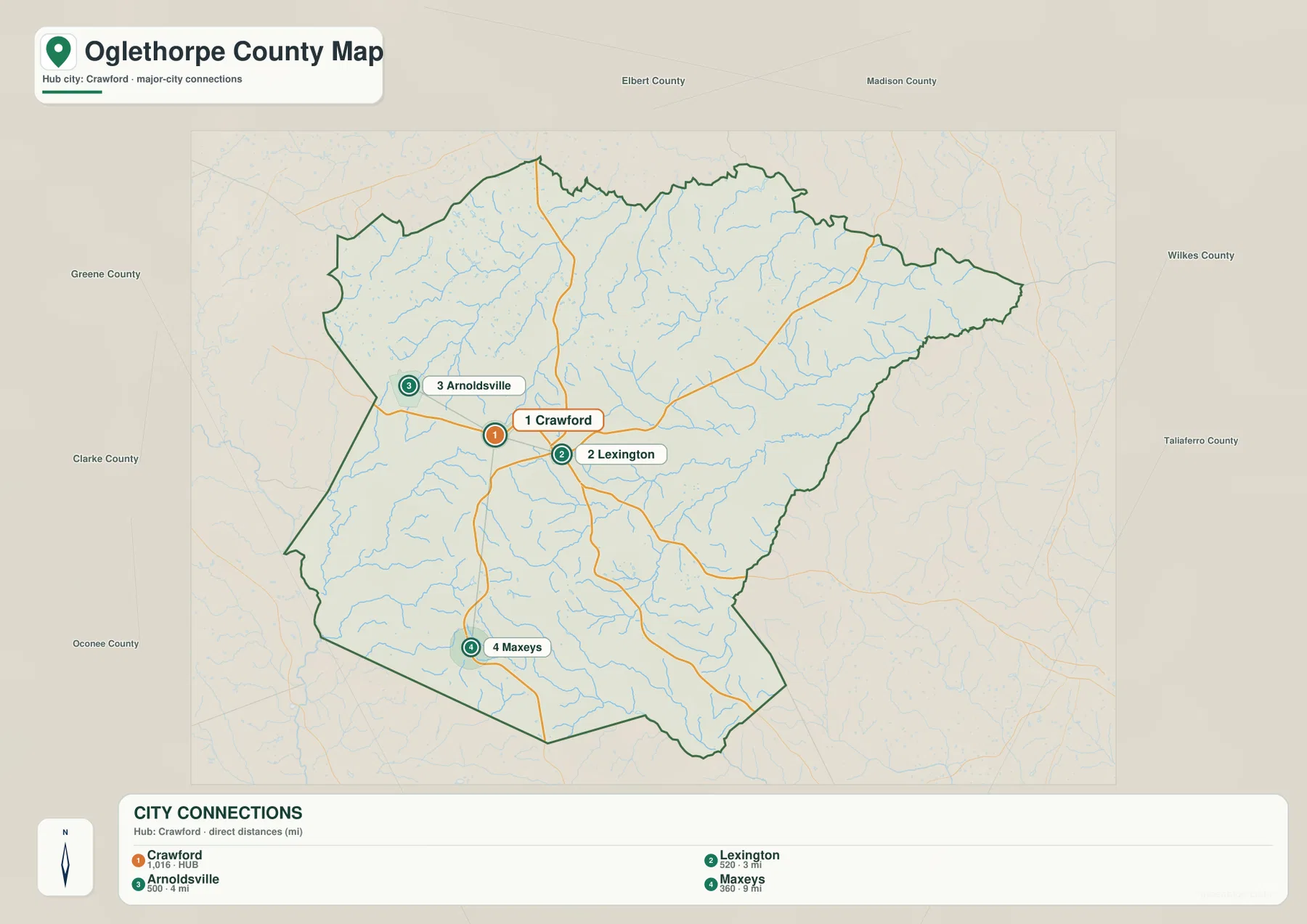
The connector mileage is a direct-distance comparison rather than driving mileage. A car route can be longer because it must follow the available roads, turns, and crossings. That matters most when comparing Maxeys with the closer Lexington-Crawford pair: the graphic is showing how far apart the points are, not promising a nine-mile road trip. For actual travel time, turn-by-turn navigation is still the right tool. For a classroom map, local-history project, or county overview, the simplified connectors make the settlement pattern much easier to explain.
The four towns also divide the western half of the county into recognizable reference areas. Arnoldsville gives you a northwestern point, Crawford and Lexington form the central pair, and Maxeys provides a southwestern point. East of Lexington, the map depends more heavily on routes, creeks, and the county outline because no comparable city marker occupies the broad eastern section. This is why the city map works best beside the county map rather than as a replacement for it: one simplifies the municipal pattern, while the other restores the roads, streams, and full boundary needed for orientation.
The Broad River and Oconee River frame different sides of the drainage network
Water gives Oglethorpe County a much more intricate appearance than the town map suggests. The Broad River is the dominant named river along the eastern side, while the South Fork Broad River crosses the northern interior toward it. The Oconee River appears at the southwestern edge, and the North Fork Little River is labeled near the southern side. Between those larger rivers, dozens of smaller blue lines occupy narrow valleys, creating a dense network that reaches almost every part of the county.
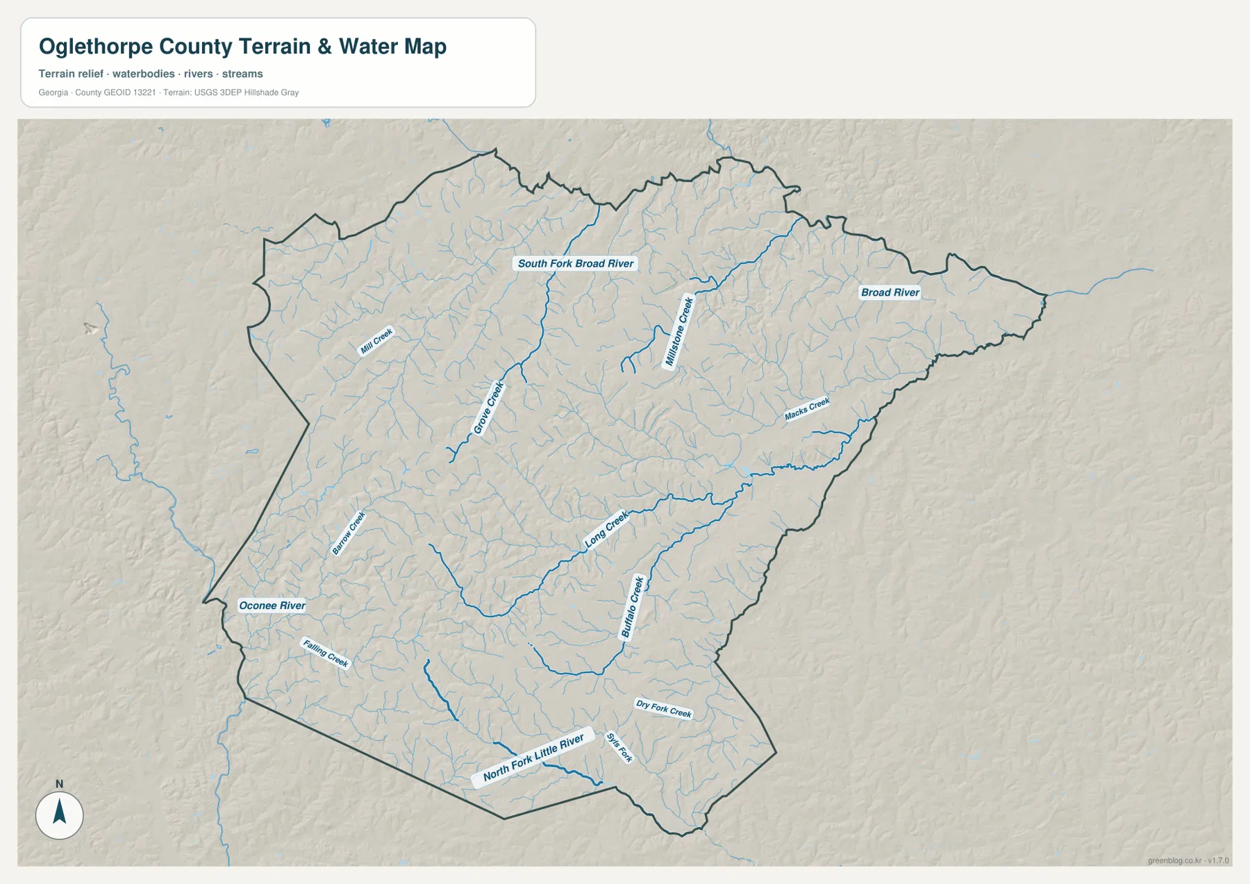
Several creek names make it possible to follow that network from one part of the county to another. Mill Creek and Grove Creek appear in the northwest and west-central area. Mission Creek runs through the north-central interior, while Macks Creek is prominent farther east. Long Creek and Buffalo Creek cross the southern half, with Barnett Creek and Falling Creek in the southwest and Dry Fork Creek farther southeast. The names are useful because they show that the county is not drained by one simple channel; different tributaries feed toward different larger rivers around the county.
This water view should not be treated as a floodplain, water-depth, water-quality, legal-boundary, or navigation map. A mapped blue line tells you where a river or stream lies at the scale of this county overview, but it does not describe conditions on a particular day or determine whether nearby land is regulated. Its value is geographic. It lets you see the Broad River side of the county, the Oconee River corner, and the smaller valleys between them without having road labels dominate the page.
Major routes cross a landscape cut by small valleys
Returning to the road map after looking at the streams explains why the transportation network does not form a neat grid. The county is crossed by many short drainage valleys, so roads bend and branch as they connect the west-central towns with the larger eastern and southern areas. The 78/10 corridor is the clearest east-west reference through Crawford and Lexington. Route 22 provides a southeastward line from Lexington, and Route 77 helps locate Maxeys and the southern side. Together they form a small set of recognizable routes that can be followed even when many local road names are omitted.
For a report or presentation, those route numbers are more useful when paired with a specific geographic feature. You can show that Crawford and Lexington share the 78/10 corridor, that Maxeys lies near the Route 77 side of the county, or that the eastern road network approaches the Broad River drainage. That makes the map more informative than a list of highway numbers. At the same time, it is important not to overread the linework: the map is designed for countywide orientation and should not be used for current traffic conditions, turn restrictions, construction updates, or exact travel planning.
Higher western ridges descend toward lower eastern valleys
The elevation map reveals a strong west-to-east contrast that is easy to miss on the road view. Warm browns and tans cover much of the western and northwestern interior, indicating relatively higher rolling ground. Greens become more extensive toward the east, especially along the Broad River side and in narrow branches that follow tributary valleys. Lower terrain also appears near the Oconee River at the southwestern edge. Rather than one continuous slope, the county consists of repeated ridges separated by stream-cut low ground.
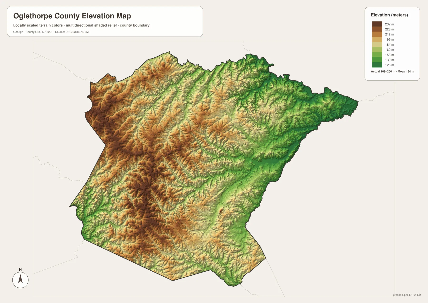
The legend reports an actual countywide range of about 109 to 250 meters, with a mean near 184 meters. Those numbers provide useful scale, but the shaded relief carries more information than any single elevation value. Thin green valleys branch through higher ground in the same places where the water map shows creeks, while the broad eastern low area corresponds with the Broad River system. Comparing the two maps side by side turns a dense network of blue lines into a more understandable picture of valleys and intervening ridges.
This is still a generalized county-scale surface. It is suitable for comparing broad terrain, illustrating local physical geography, or adding context to the river network, but it cannot replace a property survey or engineering-grade elevation data. A building site, drainage plan, road grade, or parcel-level question requires more detailed measurements. For countywide use, the main takeaway is straightforward: the western side is generally higher and more strongly ridged, while lower terrain follows the Broad River and many of the creeks toward the east and along other drainage corridors.
Choose the map that matches the question
If you are new to Oglethorpe County, begin with the county reference map. It gives you the boundary, the Lexington-Crawford pair, Arnoldsville, Maxeys, the major numbered routes, and enough water detail to orient yourself. Switch to the city-connections view when the main question is how the four mapped towns are spaced. Use the water map when river and creek names matter, and use the elevation map when you need to show why the western half looks hillier and why the eastern drainage corridors sit lower.
| Map | Best for | Important limitation |
|---|---|---|
| County reference map | Boundary, Lexington, Crawford, Arnoldsville, Maxeys, and major numbered routes | Not a parcel map or complete street directory |
| City-connections map | Comparing the four mapped towns from the Crawford hub | Connector mileage is direct distance, not driving distance |
| Water map | Broad River, Oconee River, South Fork Broad River, and named creeks | Not a flood, water-quality, or legal-boundary product |
| Elevation map | Higher western ridges and lower river or creek valleys | Not survey- or engineering-grade elevation |
Combining two maps often tells the story more clearly than trying to fit every layer onto one image. The county and city maps work well together for a civic or local-history presentation because they connect municipal names with the road network. The water and elevation maps are a natural pair for physical geography because the lower valleys correspond closely with the mapped streams. For printed classroom material, a report appendix, or a larger presentation graphic, the downloadable A3 JPG versions provide more room for labels than the WEBP previews shown in the article.
Frequently Asked Questions
Why does the city map use Crawford as the hub if Lexington is the county seat?
The hub label belongs to the city-comparison graphic, not to county government. Lexington is the county seat, while Crawford is used as the reference point for comparing the four mapped municipalities. From Crawford, the graphic places Lexington at about 3 miles, Arnoldsville at about 4 miles, and Maxeys at about 9 miles. Keeping those two ideas separate avoids confusing a map-layout choice with an administrative designation.
Where is the Broad River most visible on the Oglethorpe County maps?
The Broad River stands out along the eastern side of the water map. The South Fork Broad River crosses the northern interior toward that side, and smaller streams such as Mission Creek and Macks Creek help show how the eastern drainage network connects. The elevation map reinforces the same pattern because the Broad River side and many tributary valleys appear lower than the higher western ridges.
Can the 109–250 meter elevation range be used for a property survey?
No. The 109–250 meter range describes the elevation surface shown across the county map and is useful for broad comparison only. It helps explain the higher western terrain and lower river or creek valleys, but it is not precise enough for a property boundary, grading plan, drainage design, or construction decision. Those tasks require site-specific survey or engineering data rather than a countywide reference image.
Map File Information
The download package contains four original high-resolution A3 JPG maps of Oglethorpe County: the county reference map, city-connections map, water map, and elevation map. One ZIP provides all four files for printing, classroom use, presentations, or offline geographic reference.
- File Type: ZIP containing four JPG files
Related Maps
Sources and references
County administration and population information can be checked against official county and U.S. Census Bureau resources. The boundary, hydrography, and elevation layers correspond to public federal geographic datasets. Use the original sources below when you need current statistics, source documentation, or more detailed data than a county-scale map can provide.
- Official Oglethorpe County website
- U.S. Census Bureau QuickFacts – Oglethorpe County, Georgia
- U.S. Census Bureau TIGER/Line Shapefiles
- USGS National Hydrography
- USGS 3D Elevation Program
Green Map creates custom-edited map images using open geographic data sources such as geoBoundaries, Natural Earth, OpenStreetMap, and government open data. These maps are edited visual materials, not raw data files, and are provided for education, documents, presentations, and graphic reference.