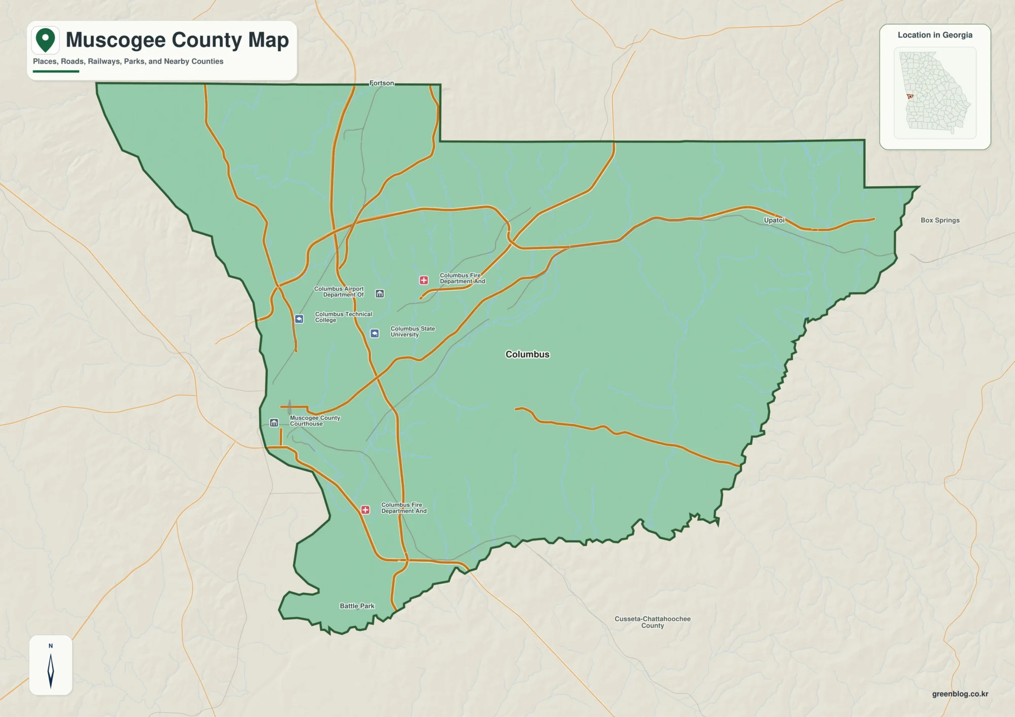
Mercer County sits on Missouri’s northern border, with Iowa immediately beyond its north line. Princeton is the easiest place to get oriented because U.S. 65 and U.S. 136 meet there, while Mercer and South Lineville continue the northward sequence toward the state line. East of that central corridor, Ravanna provides another useful place name in a landscape of local roads, creeks, and rolling uplands. The maps on this page bring those pieces together without turning the county into a dense road atlas.
You can also download the map set as high-resolution JPG files for larger viewing or printing. The ZIP includes a county map, a city-connections map, a terrain-and-water map, and an elevation map. A useful way to explore the county is to begin with the Princeton road junction, follow U.S. 65 north to Mercer and South Lineville, then compare the Weldon River corridor with the elevation colors. That sequence makes the relationship between roads, settlements, valleys, and higher ground much easier to see.
Table of Contents
Princeton anchors the county’s main road junction
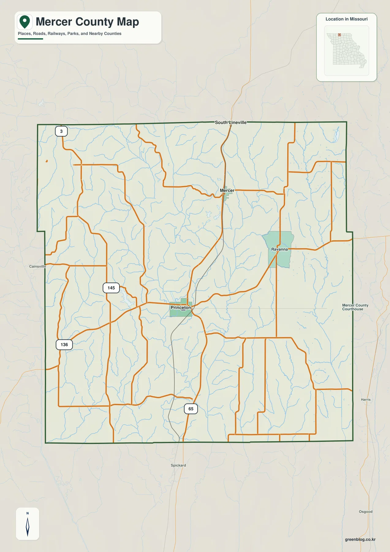
The general county map is centered on a simple but useful road pattern. U.S. 65 runs north and south through the middle of Mercer County, passing Princeton before continuing toward Mercer and South Lineville. U.S. 136 crosses the county from west to east and meets U.S. 65 near Princeton. Because those highways intersect close to the county’s geographic center, Princeton works as a practical reference point when you are trying to place smaller roads, towns, or streams on the map.
Other numbered routes fill in the western side of the county. Route 3 appears near the northwest and approaches the Iowa line, while Route 145 helps connect the western and southwestern road network with U.S. 136 and local roads. Many rural roads look fairly straight across open country, but their spacing changes around stream valleys. When the road map is compared with the water map, several bends and offsets make more sense because the routes are crossing or skirting low ground rather than following a perfectly regular grid.
South Lineville is especially useful for reading the north edge of the map. It is marked just south of the Missouri-Iowa boundary, with Mercer farther south along the U.S. 65 corridor and Princeton farther south again. The county map also labels places outside Mercer County, including Cainsville to the west, Spickard to the south, and Harris and Osgood to the east. Those neighboring names help show how local roads continue beyond the county boundary without making them part of Mercer County itself.
This map is intended for geographic reference rather than turn-by-turn navigation. It does not show current construction, temporary closures, private-road access, or live traffic conditions. For travel planning, use current transportation information as well. Here, the value of the road layer is in seeing where the larger routes meet, how the smaller network spreads out from them, and how close each settlement lies to the Iowa border or to neighboring counties.
Small towns give the rural map its reference points
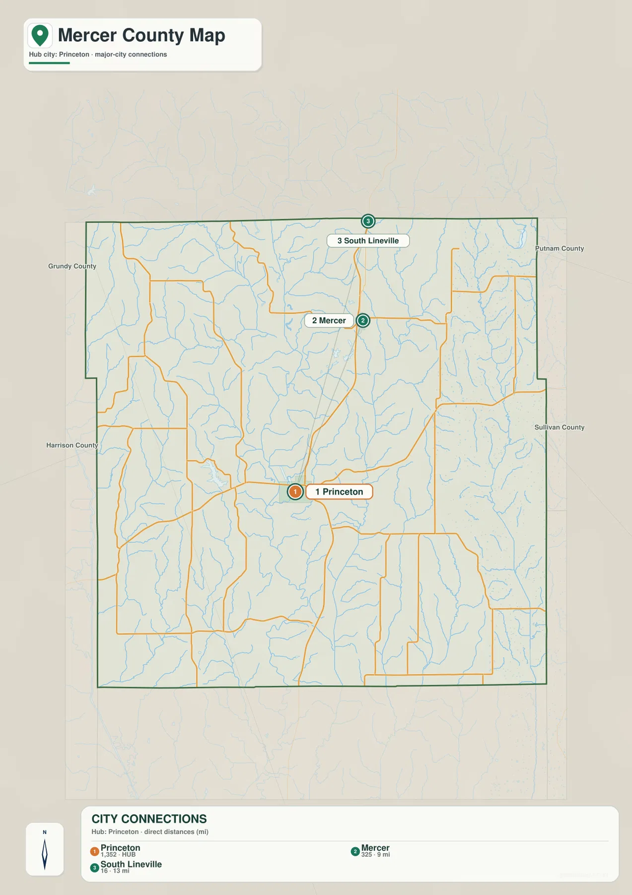
Mercer County does not need a long list of cities to be understandable. Princeton, Mercer, South Lineville, and Ravanna already provide a useful set of anchors. Princeton combines the county-seat role with the junction of the two principal U.S. highways. Mercer marks the next major point north along U.S. 65, and South Lineville makes the state boundary easy to locate. Ravanna is different: it sits east of the central highway corridor and helps identify the county’s eastern rural area.
The city-connections map simplifies the road background so those relationships stand out more clearly. It is useful when a full road-and-stream map feels too busy, particularly for classroom work, presentations, or a quick check of where one settlement lies relative to another. Rather than presenting every minor road with equal weight, it keeps attention on the places that help a reader move mentally from central Mercer County to the north border and then across to the east.
Princeton’s importance is not only a product of the modern road network. The State Historical Society of Missouri maintains material on Mercer County place names, and the University of Missouri Extension has information about the Mercer County courthouse. Those references provide historical background for why Princeton appears so prominently in county material. The map itself remains a geographic tool, but the supporting sources help explain why a small town can serve as both an administrative center and the most recognizable point in the local road system.
Weldon River forms the clearest natural corridor
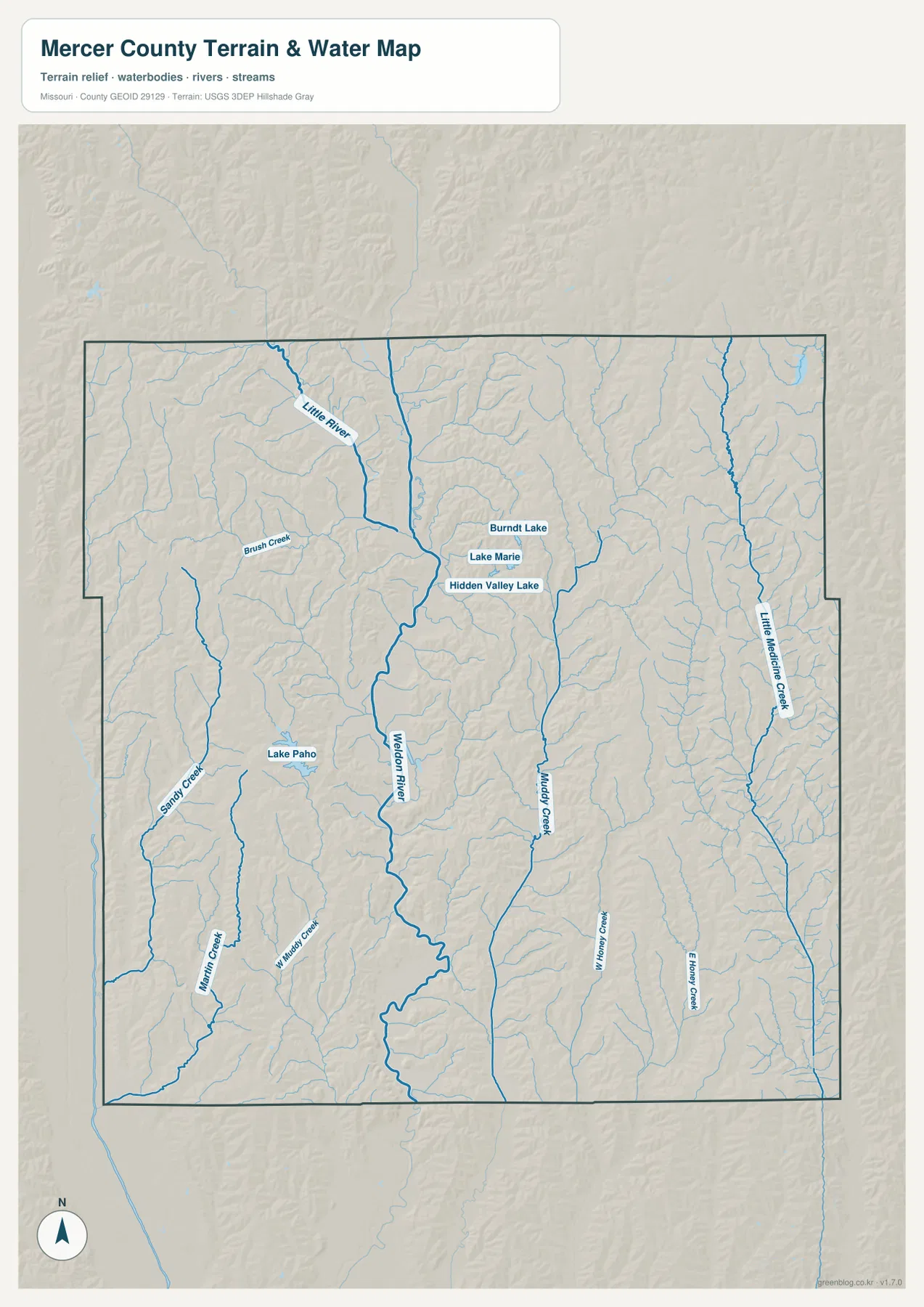
The terrain-and-water map changes the emphasis from roads to valleys. Weldon River is the most obvious continuous watercourse, entering from the north-central part of the county and winding south through the middle. Its course is not a straight line, and that is important when comparing it with the road map. The river follows lower ground, while many roads cross between ridges or approach the valley from either side. This makes the central part of Mercer County look very different when water and relief are emphasized.
Several named streams help divide the rest of the county into smaller areas. Little River is prominent in the northwest. Brush Creek and Sandy Creek are shown farther west, while Big Muddy Creek appears in the southwest. Muddy Creek lies east of Weldon River, and Little Medicine Creek runs near the eastern side. Farther south and east, W. Honey Creek and E. Honey Creek create another pair of long, narrow valleys. These are not merely labels on blue lines; they correspond to low cuts that also appear in the shaded terrain.
Lakes provide useful landmarks in a county where many streams are narrow. Lake Paho is marked in the west-central area and is easy to find near the Sandy Creek side of the map. Burnt Lake, Lake Marie, and Hidden Valley Lake appear closer together in the north-central part of the county. None of these water bodies dominates Mercer County at the scale of a major regional reservoir, but each gives the reader another fixed point for locating surrounding roads, creek valleys, and nearby higher ground.
The water map should not be treated as a flood map or a source for boating conditions, water depth, water quality, or access rules. Those questions require current information from the appropriate agencies. Its purpose here is narrower and more useful for a general county page: it shows where named rivers, creeks, and lakes sit in relation to the terrain, and it makes the branching valley system visible in a way the road map cannot.
A 236–337 meter range reveals the central low ground
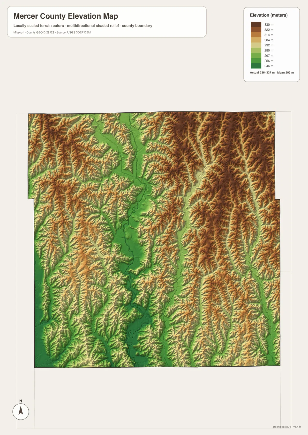
The elevation map places Mercer County between about 236 and 337 meters, with a mapped mean near 293 meters. Green represents the lower elevations, while yellows, oranges, and browns indicate progressively higher ground. The most striking feature is the broad green corridor through the center of the county. That lower area follows the Weldon River system and becomes especially clear toward the south, where the river bends through a deeper-looking network of tributary valleys.
Higher terrain is more extensive east and northeast of the central valley. It is not a mountain belt; instead, closely spaced ridges and small valleys create rolling relief. Little Medicine Creek and the Honey Creek branches cut lower lines through that higher ground. The northwest is also uneven, with lower land near Little River and short ridges between drainage lines. This explains why Mercer County can appear broadly agricultural on a road map while still showing a great deal of local relief on the elevation map.
Princeton lies near the western side of the central low corridor, and U.S. 65 passes through comparatively moderate terrain for much of its north-south course. That does not mean the highway simply follows the Weldon River, but the two maps together show how transportation and topography interact. A road that looks like a clean line on the general map is crossing a landscape of ridges, tributaries, and valley floors, which is easier to appreciate once the elevation colors are visible.
The colors are generalized for county-scale comparison and should not be used as survey elevations for individual buildings, bridges, or property corners. The map is best for identifying broad differences such as the lower Weldon River corridor and the higher eastern uplands. If exact elevation is needed, USGS 3D Elevation Program data or a professional survey is the appropriate source. At this scale, the colored relief is a visual guide to where the county rises and falls.
Princeton and Ravanna show two different parts of the county
Princeton is where the map layers overlap most clearly. The road map shows the U.S. 65-U.S. 136 junction, the city map makes Princeton the central settlement reference, the water map places Weldon River nearby to the east, and the elevation map shows lower terrain associated with that river corridor. Looking at those details together explains why Princeton is such a convenient starting point for the county even though the maps are designed to highlight different information.
Ravanna provides a useful contrast. It lies east of the central U.S. 65 corridor, where local roads are more important than the main north-south highway. The nearby water network includes Little Medicine Creek and the Honey Creek system, while the elevation map shows more widespread higher ground than around the central Weldon corridor. A reader who only studies the Princeton junction could miss how much the eastern half of Mercer County is defined by small ridges and stream valleys rather than by a single major route.
The northern settlements offer a third comparison. Mercer and South Lineville are both close to U.S. 65, but South Lineville is immediately associated with the state boundary while Mercer is farther inside the county. Burnt Lake, Lake Marie, and Hidden Valley Lake add landmarks near the north-central area, and Little River marks a separate drainage farther west. Together, those features keep the northern portion of the map from being reduced to a simple highway line between Princeton and Iowa.
Choosing a map for print, study, or local reference
Use the county map when roads, town names, and the boundary matter most. It is the quickest choice for locating the Princeton highway junction, following U.S. 65 toward the Iowa line, or seeing where Ravanna sits relative to the rest of Mercer County. The city-connections map is cleaner when the goal is simply to explain the positions of Princeton, Mercer, and South Lineville without asking the reader to sort through every stream and minor road.
For natural features, the terrain-and-water map is the more informative choice because named rivers, creeks, and lakes are easier to follow against shaded relief. It works well for comparing Weldon River with Little River, Lake Paho, Muddy Creek, and the eastern tributaries. The elevation map is better when exact place labels are less important than the difference between low valleys and higher ridges. Putting those two maps side by side makes the central Weldon corridor particularly easy to recognize.
The WebP images in the article are designed for efficient on-screen viewing, while the downloadable JPG files provide a larger version for close inspection and printing. They can be useful for classroom handouts, local-history notes, trip planning, or personal reference. They are not substitutes for legal boundary surveys, official flood determinations, parcel ownership records, or live road information, so decisions that depend on current or legally precise data should always be checked against the responsible agency.
Frequently Asked Questions
Which major highways meet at Princeton?
U.S. 65 and U.S. 136 meet at Princeton. U.S. 65 is the main north-south reference toward Mercer and South Lineville, while U.S. 136 provides the clearest east-west route across the county. Their junction is a practical starting point for locating the county’s towns and waterways.
Why does the middle of the elevation map appear lower?
Much of the green low-elevation corridor follows the Weldon River and its tributary valleys through central Mercer County. The eastern and northeastern areas contain more orange and brown uplands, so the contrast is easy to see. Comparing the water and elevation maps side by side makes the relationship especially clear.
What is included in the downloadable Mercer County ZIP?
The ZIP contains four high-resolution JPG files: the county map, city map, terrain-and-water map, and elevation map. They are intended for closer viewing, A3 printing, and use in larger documents, while the WebP images in the article are optimized for on-page viewing.
Map File Information
The download ZIP contains high-resolution JPG versions of the Mercer County map, city map, terrain-and-water map, and elevation map.
- File Type: JPG
Related Maps
Sources and reference links
For additional information about Mercer County place names, local history, boundaries, hydrography, and elevation, the following public and official sources are useful companions to the maps.
- State Historical Society of Missouri – Mercer County Place Names
- University of Missouri Extension – Mercer County Courthouse
- Visit Mercer County, Missouri
- U.S. Census Bureau TIGER/Line Shapefiles
- USGS National Hydrography
- USGS 3D Elevation Program
Green Map creates custom-edited map images using open geographic data sources such as geoBoundaries, Natural Earth, OpenStreetMap, and government open data. These maps are edited visual materials, not raw data files, and are provided for education, documents, presentations, and graphic reference.