The DeKalb County Alabama Map set explains a county where mountains and valleys have a direct effect on roads, towns, and travel. Fort Payne sits in low Big Wills Valley, with Interstate 59 and U.S. 11 following the same northeast–southwest passage. Sand Mountain rises to the west and contains Rainsville, Fyffe, Geraldine, and several other communities. Lookout Mountain rises east of Fort Payne, where Mentone, DeSoto State Park, and the Little River system occupy much higher ground.
Four downloadable A3 JPGs let you examine those relationships without crowding everything onto one sheet. The general map combines the county line, towns, highways, streams, and nearby places. The city map highlights six leading population centers. Water and terrain receive a dedicated map, and a shaded elevation sheet makes the central valley and flanking uplands especially clear. The ZIP download near the end of the article contains all four original high-resolution files.
Table of Contents
Roads Through Big Wills Valley and Across the Mountains
Fort Payne is the easiest place to begin on the county map because the major transportation lines meet there. I-59 and U.S. 11 run through Big Wills Valley, linking Collinsville in the south with Fort Payne and the Valley Head direction in the northeast. The railroad follows a similar low corridor. Instead of repeatedly climbing ridges, these routes use a long natural passage between Sand Mountain and Lookout Mountain.
Alabama 35 provides a different kind of connection. West of Fort Payne, it heads toward Rainsville and the Sand Mountain side. East of town, it climbs Lookout Mountain toward Little River Falls and the canyon area. Alabama 75 serves the western plateau as a north–south road through Geraldine, Fyffe, Rainsville, Henagar, and Ider. Reading I-59 and AL 75 as roughly parallel routes helps separate valley travel from movement across the plateau.
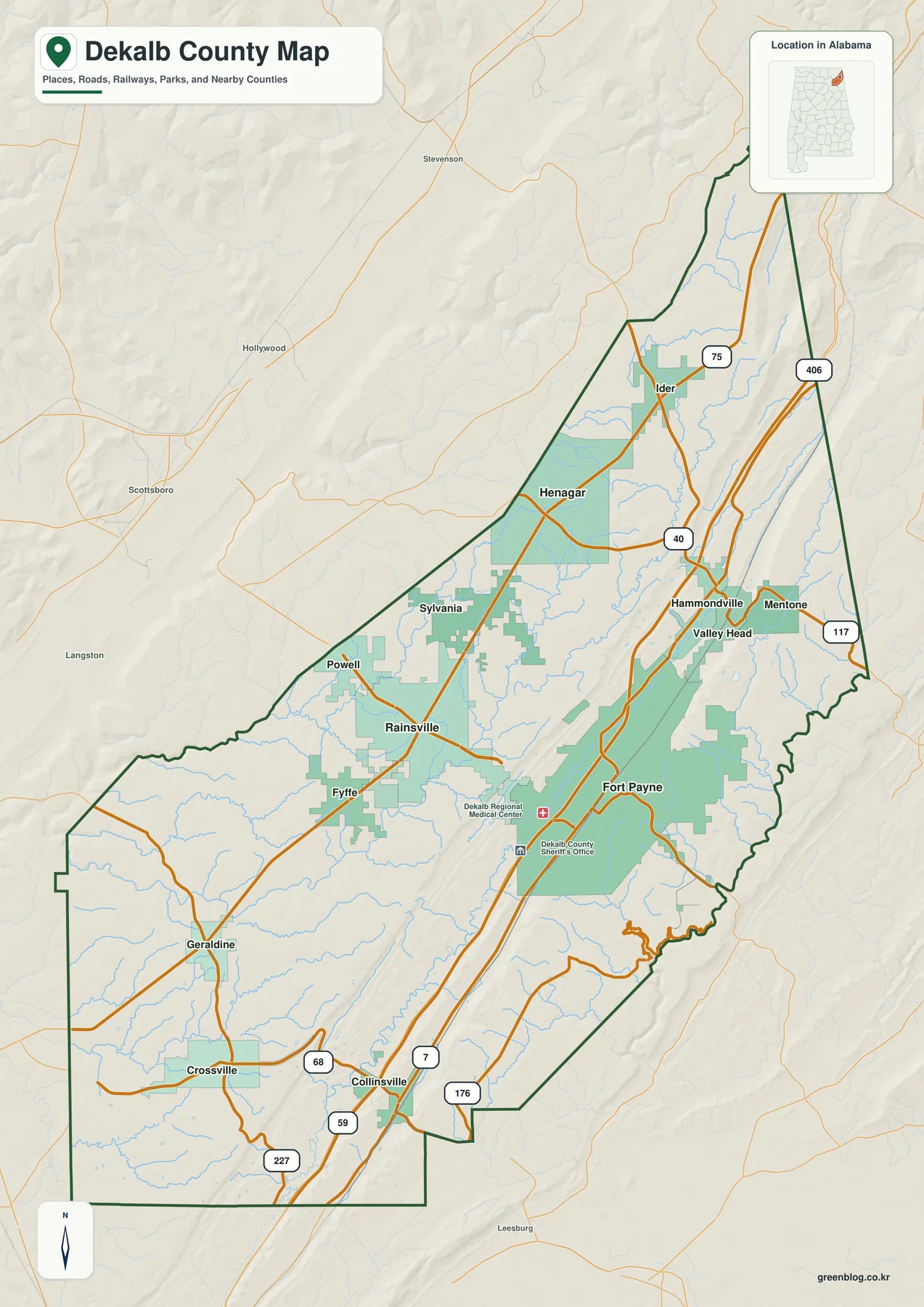
The county extends diagonally across northeastern Alabama. Jackson and Marshall counties are to the west, Etowah and Cherokee counties meet the southern side, and Georgia lies along the eastern boundary. The far northeast is also close to Tennessee. Labels such as Scottsboro, Stevenson, and Leesburg sit outside DeKalb County but help orient the viewer toward nearby destinations. The dark green line is the administrative boundary; roads and streams continue naturally beyond it.
Within the boundary, the general sheet labels Fort Payne, Rainsville, Henagar, Ider, Sylvania, Powell, Fyffe, Geraldine, Crossville, Collinsville, Hammondville, Mentone, and Valley Head. The most useful way to organize them is by terrain rather than alphabetically. Fort Payne and Collinsville are close to the valley corridor, Rainsville and Fyffe occupy the western upland, and Mentone belongs to the Lookout Mountain side. This grouping also suggests which roads are likely to be most direct.
Six Cities Across Three Different Terrain Zones
The city map ranks six major places and strips away many smaller labels. Fort Payne is first with 14,927 residents, followed by Rainsville at 5,702. Henagar is shown with 2,501 people, Crossville with 2,143, Sylvania with 1,925, and Collinsville with 1,781. Fort Payne is clearly the largest center, yet the remaining population is distributed across the northern, western, and southern parts of the county rather than clustered in one suburban ring.
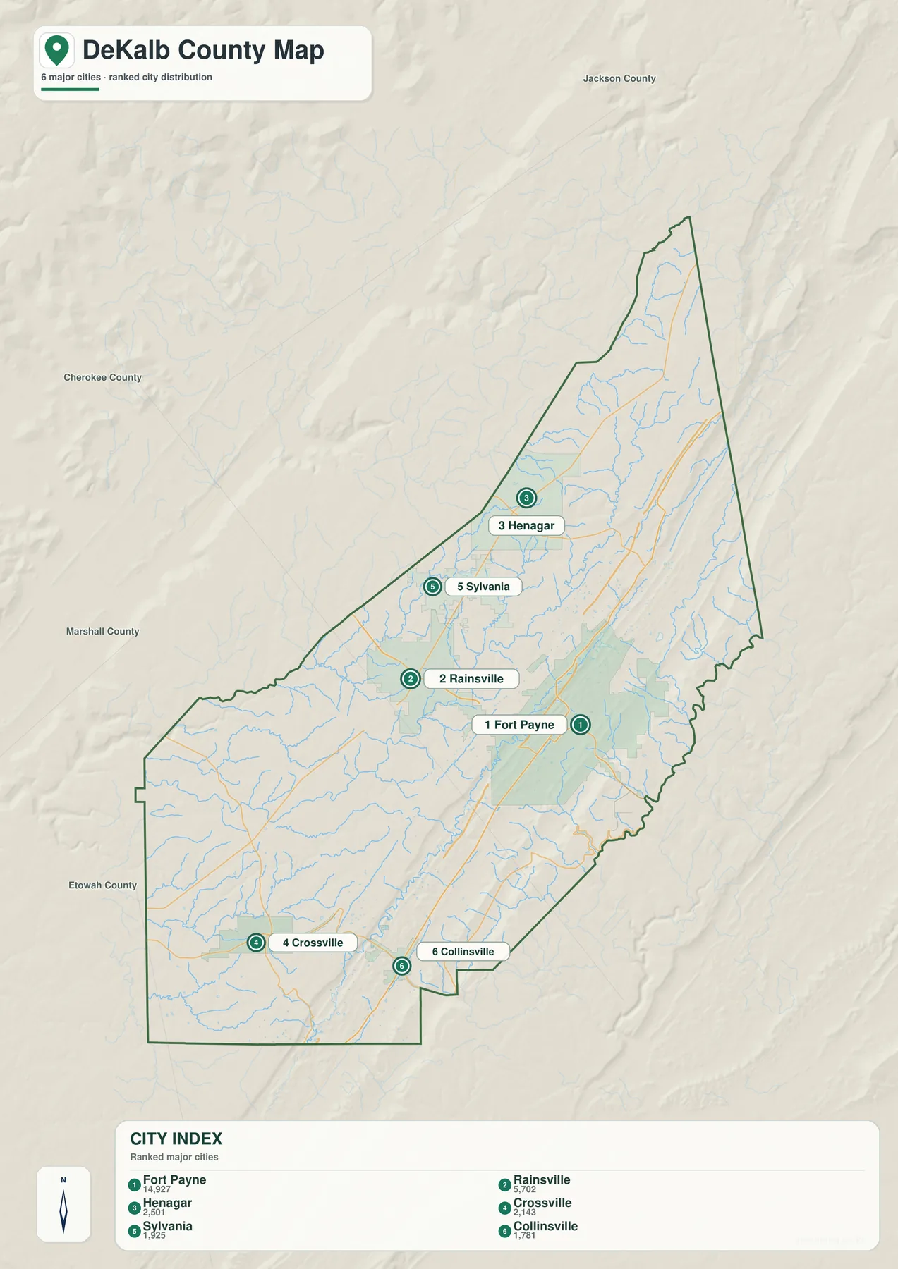
Rainsville is the principal western reference on Sand Mountain. Henagar and Sylvania help define the more rural north, while Crossville anchors the southwestern plateau. Collinsville lies near the southern end of the I-59 and U.S. 11 valley route. Each place therefore has a different relationship with Fort Payne: some share the low transportation corridor, while others require a climb to higher terrain before the route turns north or south.
This distinction matters when estimating travel. Fort Payne and Mentone appear close on a flat page, but Mentone is on top of Lookout Mountain. A trip between them includes a substantial elevation change and curving mountain roads. Fort Payne and Collinsville, by contrast, are connected by the valley corridor. Straight-line separation alone does not capture those differences, so the city map works best when it is viewed beside the highway and elevation sheets.
Little River, Big Wills Creek, and the County’s Lakes
Little River is the dominant water feature on the eastern side. Its East Fork and West Fork run across Lookout Mountain, join, and continue south toward the canyon. Red River Branch enters the system from the northeast. Unlike a typical river that starts on a mountain and quickly descends into a broad lowland, much of Little River remains on the upland before cutting deeply into sandstone. That setting gives the eastern county both high terrain and a major gorge.
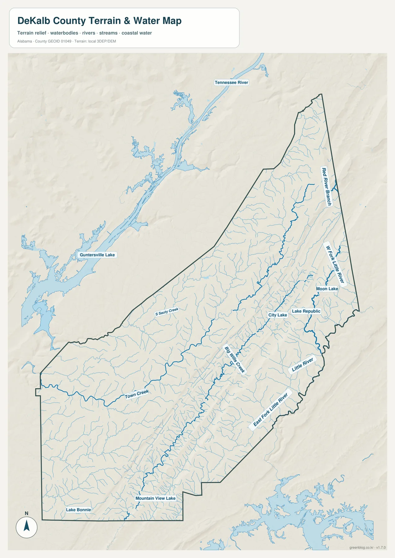
Big Wills Creek runs along the central low corridor near Fort Payne. Its direction closely matches the valley that carries I-59, U.S. 11, and the railroad. Town Creek crosses the western half of the county, and South Sandy Creek appears farther north on the plateau. Dozens of thinner blue lines show tributaries descending from ridges into these larger channels. The network is especially dense where narrow valleys cut the uplands.
Named standing waters include City Lake, Lake Republic, Moon Lake, Mountain View Lake, and Lake Bonnie. Guntersville Lake and the Tennessee River appear outside the county to the northwest, providing context for the larger regional drainage. A large reservoir is also visible beyond the southeastern boundary. These outside features are background references rather than waters located inside DeKalb County.
The map is meant for geographic reference, not flood analysis or navigation. It does not establish water depth, current speed, property ownership, or safe access. Little River can change considerably after rainfall, and conditions in the canyon may differ from what a static map suggests. Visitors should check current National Park Service notices before entering river or canyon areas.
A Low Valley Between Sand Mountain and Lookout Mountain
The elevation sheet reveals three long bands more clearly than any town list can. A dark green valley crosses the county from southwest to northeast. Higher yellow, tan, and brown ground lies on both sides. The legend reports an actual elevation range of about 188 to 599 meters and a county mean of 371 meters. Colors are scaled locally to emphasize variation inside DeKalb County, so they should not be matched directly with the palette on another county map.
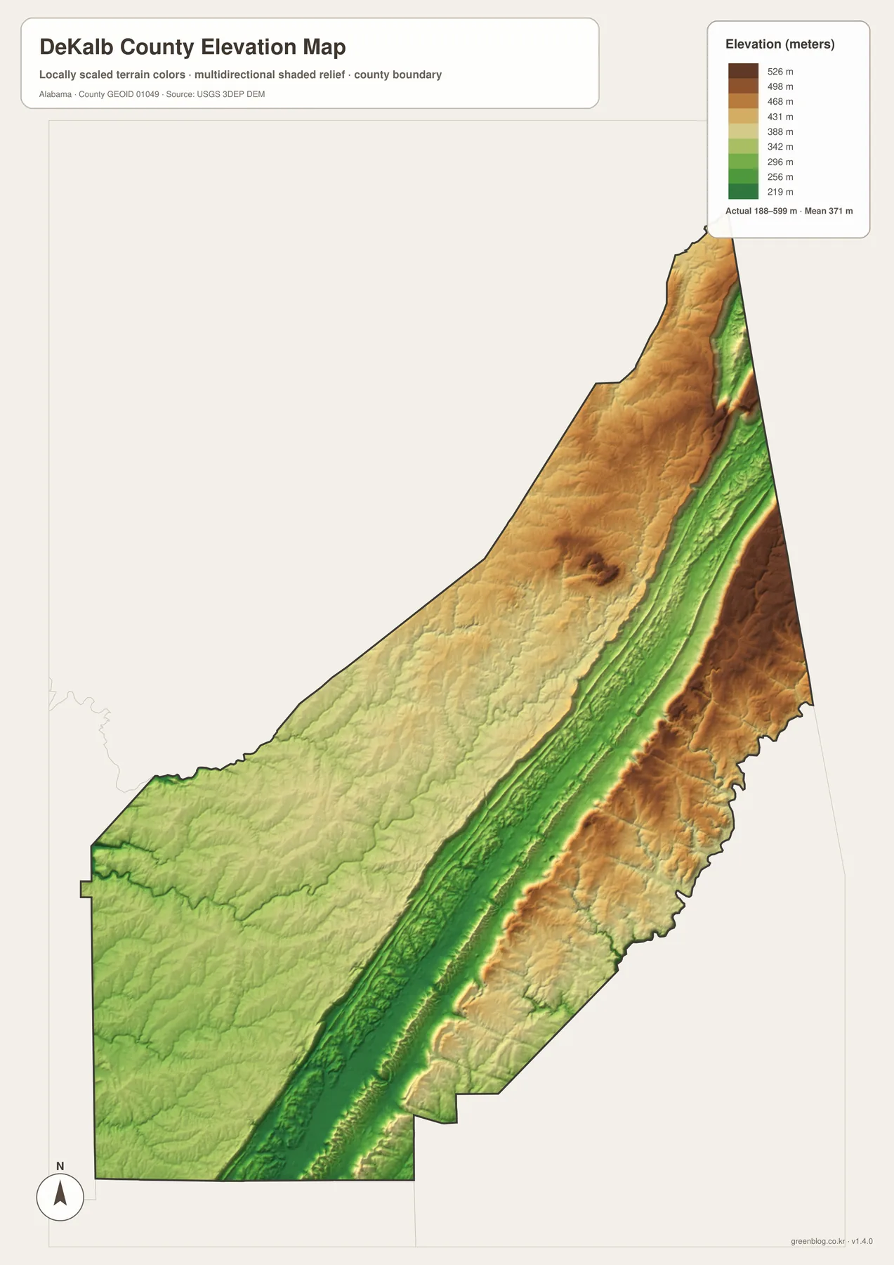
Big Wills Valley runs from the Collinsville area through Fort Payne toward Valley Head. The alignment of I-59 and U.S. 11 with this low band is immediately visible when the elevation and road maps are compared. Fort Payne occupies a place where travel can continue along the valley or turn west and east toward higher land. The city’s importance reflects both its central position and its access to the easiest long-distance route through the county.
Sand Mountain is broader and more plateau-like on the western side, providing room for Rainsville and a chain of smaller municipalities. Lookout Mountain rises sharply east of the valley and contains more deeply cut drainage, including the Little River gorge. Mentone and DeSoto State Park are on this elevated side. The short horizontal distance from Fort Payne hides a large vertical transition, which is why road curves and grades matter so much for local travel.
This generalized elevation surface is suitable for recognizing ridges, valleys, plateaus, and canyon country. It is not a survey-grade product and should not be used to determine the precise height of a building site, the slope of a driveway, or a legal boundary. Detailed projects require professional measurements and the appropriate official elevation data.
Using the Maps for Study, Travel, and Print
Choose the general map when you need boundaries, highways, incorporated places, nearby towns, and streams together. The ranked city sheet is useful for comparing Fort Payne with smaller centers across Sand Mountain and the northern county. Follow Little River, Big Wills Creek, and the named lakes on the water map. Use the elevation view when the main question involves the valley floor, plateau tops, or the climb toward Mentone and the canyon.
For a classroom activity, locate Fort Payne first and trace I-59 north and south through Big Wills Valley. Then move west to Rainsville and east to Mentone, using the elevation colors to explain why the routes differ. A physical-geography lesson can follow the East and West forks of Little River before comparing the river’s mountain course with Big Wills Creek in the central valley.
Travelers can use the sheets to understand the broad location of AL 35, AL 75, and the Little River Canyon side before checking live directions. Printed copies are also suitable for labels, route sketches, personal reference, or presentations. The A3 JPGs retain sharper lines and place names than a small browser screenshot and can be scaled down when a smaller page is needed.
Frequently Asked Questions
Why can a Fort Payne–Mentone trip take longer than the map distance suggests?
Fort Payne is on the floor of Big Wills Valley, while Mentone is on top of Lookout Mountain. The route must gain substantial elevation and follow curving mountain roads. Weather, road conditions, and the exact destination can also affect travel time.
Does Little River flow through downtown Fort Payne?
No. Little River flows across the Lookout Mountain side east of Fort Payne and continues into the canyon. The city occupies the lower Big Wills Valley, separated from the river system by higher terrain. Alabama 35 climbs east from town toward Little River Falls and the preserve.
What is included in the downloadable ZIP?
The archive contains four high-resolution A3 JPGs: a county boundary and road map, a ranked city map, a terrain-and-water map, and an elevation map. Each file can be opened or printed separately after the ZIP is downloaded.
Map File Information
DeKalb County A3 Map Files
- Included Files: County boundary and road map, ranked city map, terrain-and-water map, and elevation map
- File Type: Four high-resolution A3 JPG files in one ZIP archive
- Intended Use: Printing, education, presentations, and map-based projects
Related Maps
- Autauga County Map
- Barbour County Alabama Map
- Butler County Alabama Map
- Alabama Population Density Map: Urban Clusters, County Totals and a Decade of Change
Sources and Further Reference
- City of Fort Payne official history
- ALDOT Highway Functional Classification Maps
- National Park Service: Little River conditions
- NPS Little River Canyon Rim Parkway
- DeSoto State Park official information
- USGS 3D Elevation Program
Green Map creates custom-edited map images using open geographic data sources such as geoBoundaries, Natural Earth, OpenStreetMap, and government open data. These maps are edited visual materials, not raw data files, and are provided for education, documents, presentations, and graphic reference.