The Elmore County Alabama Map set is centered on Wetumpka but reaches into several very different parts of east-central Alabama. Millbrook and Coosada face the Montgomery metropolitan area in the southwest. Lake Jordan shapes the northern Coosa River corridor, while Eclectic and Tallassee orient the eastern side toward the Tallapoosa River and Lake Martin. South of Wetumpka, the Coosa and Tallapoosa rivers meet and continue as the Alabama River.
This page provides four downloadable A3 JPGs rather than forcing every detail onto one crowded graphic. The county map combines boundaries, highways, places, and streams. A separate city sheet ranks six population centers, the water map follows the major rivers and named lakes, and the elevation map distinguishes northern hills from the low southern river country. All four original high-resolution files are included in one ZIP near the end of the article.
Table of Contents
Wetumpka as the County’s Road and River Hub
Wetumpka lies a little southwest of the county’s center. U.S. 231 arrives from the Montgomery direction, passes through the city, and continues north. Alabama 14 crosses it and provides the principal east–west route toward Millbrook and Coosada on one side and Elmore and Tallassee on the other. Government offices, medical facilities, and the built-up area cluster around this junction, making Wetumpka the most practical orientation point even though Millbrook has a larger population.
Routes 111 and 143 serve Deatsville, Holtville, and the Lake Jordan side. Alabama 63 heads toward Eclectic, while routes 44, 50, 229, and 361 divide the northeastern and Tallassee approaches. The county has many winding local roads because streams, reservoir arms, and hills interrupt direct travel. A short line between two places may not match the road mileage when the route must reach a bridge or circle a cove.
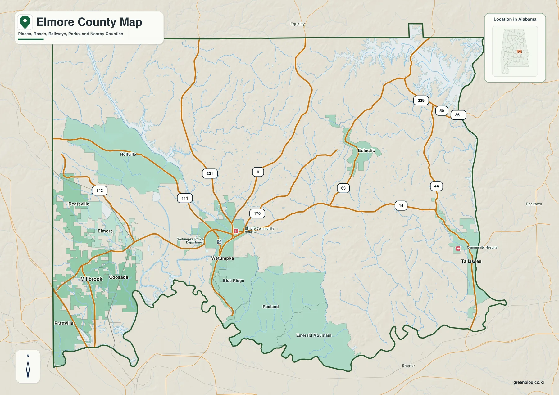
Millbrook and Coosada form the most developed southwestern area, closely tied to Montgomery, Prattville, and the I-65 network just beyond the map’s main road labels. Prattville presents an administrative detail worth noting: most of the city is in Autauga County, but a portion extends into Elmore County. Tallassee creates a similar cross-county situation on the eastern boundary, where the city continues into Tallapoosa County.
The southern county line follows a highly irregular course near the rivers, while much of the northern line is straighter. Autauga and Chilton counties are to the west, Montgomery County is southwest, and Tallapoosa and Macon counties are east or southeast. Equality, Reeltown, and Shorter appear outside the boundary as regional reference points. These labels help with direction but should not be mistaken for Elmore County communities.
Six Population Centers from Millbrook to Tallassee
The city map ranks Millbrook first with 17,189 residents. Wetumpka follows at 7,437, Tallassee at 5,134, Deatsville at 2,097, Elmore at 1,517, and Eclectic at 1,141. The ranking makes Millbrook’s suburban growth visible, but the geographic spread is just as important. The six places occupy the southwest, central, northern, eastern, and far-eastern parts of the county rather than one continuous urban strip.
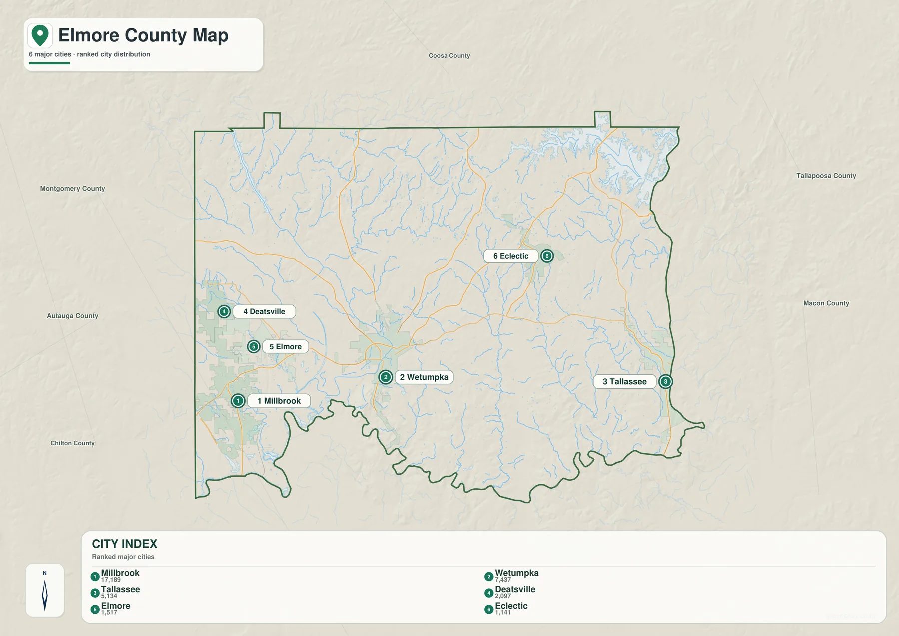
Millbrook’s location reflects the influence of jobs, housing, shopping, and highway access around Montgomery and Prattville. Wetumpka serves a different role as county seat and U.S. 231 crossing on the Coosa River. Deatsville and Elmore mark the western side between those two stronger centers and the Lake Jordan approaches. Eclectic stands in the northeastern interior, while Tallassee sits directly on the Tallapoosa River.
These places should not be treated as identical dots. A drive through the southwest follows a denser suburban road network; a trip near Lake Jordan may bend around water; and travel toward Tallassee uses the eastern highway and river corridor. The city map is deliberately simple, so the general and water sheets supply the missing explanation for why routes between communities take their particular shapes.
Three Rivers and the Long Shoreline of Lake Jordan
The Coosa River enters the northwestern county and broadens into Lake Jordan before reaching Wetumpka. The reservoir’s branching coves produce an irregular shoreline around the Holtville area. Downstream, the river continues south to its meeting with the Tallapoosa. From that confluence, the combined waterway is called the Alabama River and bends west and south along the county edge.
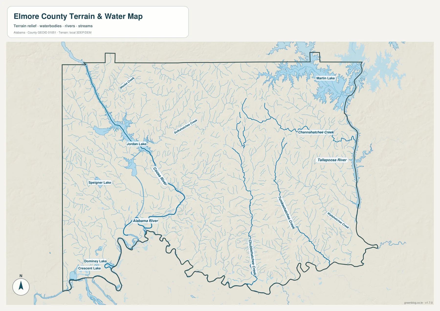
The Tallapoosa River follows the eastern boundary through Tallassee before turning toward the southern confluence. Part of Lake Martin appears in the northeast, and Channahatchee Creek enters the Tallapoosa system from the interior. Little Conecuh Creek and Grubbranch Creek run south through the central and southeastern county, while Wallahatchie Creek provides another eastern reference.
Western waters include Weoka Creek and Sofkahatchee Creek. Speigner Lake lies southwest of Lake Jordan, and Dominey Lake and Crescent Lake appear near the far southwestern boundary. The many thin tributaries explain why the terrain looks heavily cut by small valleys even away from the three major rivers. They also show that northern, eastern, and southern communities do not all drain toward the same nearby channel.
This sheet is a reference map, not a flood, property, or navigation product. It does not provide depth, current velocity, flood probability, boat routes, or legal ownership. Lake and river conditions can change, so recreation and safety decisions should use current information from the responsible agencies.
Northern Hills, Southern Lowlands, and the Wetumpka Crater
The elevation map changes from green lowlands in the south and southwest to tan and brown hills across much of the north and northeast. Its legend reports an actual range of about 37 to 233 meters and a mean elevation of 114 meters. The color scale is adjusted for variation within Elmore County, so matching colors on a different county map may represent different heights.
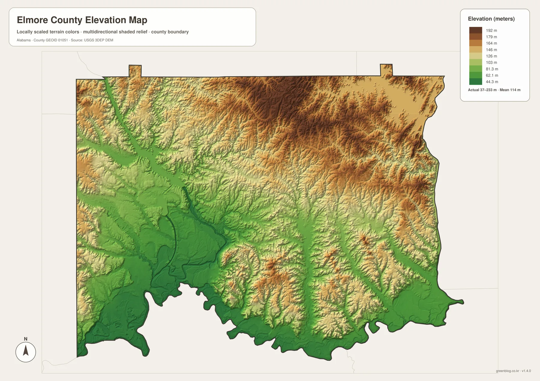
The Coosa valley cuts a distinct green route into the higher northwestern terrain before widening around Lake Jordan. East of the reservoir, closely spaced ridges and valleys create a rougher surface. The Tallapoosa also forms a lower corridor along the eastern edge. Both river valleys descend toward the broad southern lowlands near their confluence.
East of downtown Wetumpka, an unusual group of hills is associated with an ancient impact structure. City information describes a crater roughly five miles wide, created about 85 million years ago, with part of its eroded rim still visible in the modern landscape. This feature is unrelated to Lake Jordan: the crater is a geological remnant, whereas the reservoir was created by Jordan Dam on the Coosa River.
The shaded surface is suitable for seeing broad changes in elevation, but it is not a site survey. It cannot establish the exact height of a lot, the grade of a road, a construction level, or a legal boundary. Detailed work requires professional measurement and the appropriate official datasets.
Choosing and Printing the Map Files
Use the general sheet when you need the county outline, Wetumpka, surrounding municipalities, numbered roads, streams, and neighboring places together. The city map gives a quick comparison of Millbrook’s population and Wetumpka’s central location. The water sheet is best for tracing Lake Jordan and the three-river system, while the elevation map explains the contrast between northern hills and low ground near the southern confluence.
A classroom exercise can begin by marking U.S. 231 north and south of Wetumpka and Alabama 14 east and west. Students can then trace the Coosa and Tallapoosa rivers to their meeting point, followed by a comparison with the elevation colors. For local-history work, the same layout helps place the Fort Toulouse–Fort Jackson area at the river junction and the impact structure east of Wetumpka without confusing the two features.
Travelers can use the maps for broad orientation before checking live directions and road conditions. The original A3 JPGs also work well for printed labels, presentations, route sketches, or personal reference. They can be scaled down for smaller paper while the full-size originals remain available for the sharpest text and lines.
Frequently Asked Questions
Where do the Coosa and Tallapoosa become the Alabama River?
The two rivers meet south of Wetumpka near the county’s irregular southern boundary. Below the confluence, the combined channel is called the Alabama River. The location is easiest to find by tracing the Coosa from the northwest and the Tallapoosa from the east on the water map.
Why do Tallassee and Prattville extend across county lines?
Municipal boundaries do not always stop at county boundaries. Tallassee extends into both Elmore and Tallapoosa counties, while part of Prattville reaches into Elmore County from Autauga County. A separate municipal-boundary layer is needed when exact jurisdiction matters.
Are the Wetumpka impact crater and Lake Jordan the same type of feature?
No. The Wetumpka structure is the eroded remnant of an ancient impact, while Lake Jordan is a modern reservoir created by a dam on the Coosa River. The crater is east of downtown Wetumpka, and the reservoir stretches north of the city.
Map File Information
Elmore County A3 Map Files
- Included Files: Map files described on this page
- File Type: ZIP archive
- Intended Use: Printing, education, presentations, and map-based projects
Related Maps
- Autauga County Map
- Barbour County Alabama Map
- Butler County Alabama Map
- Alabama Population Density Map: Urban Clusters, County Totals and a Decade of Change
Sources and Further Reference
- Elmore County Commission official geography and history
- Elmore County official municipality information
- City of Wetumpka impact crater information
- Alabama Historical Commission: Fort Toulouse-Fort Jackson
- Alabama Power: Jordan Dam and Lake Jordan
- USGS 3D Elevation Program
Green Map creates custom-edited map images using open geographic data sources such as geoBoundaries, Natural Earth, OpenStreetMap, and government open data. These maps are edited visual materials, not raw data files, and are provided for education, documents, presentations, and graphic reference.