Henry County lies southeast of Atlanta, with McDonough as the county seat and Stockbridge, Locust Grove, and Hampton forming other major settlement centers. Interstate 75 is the strongest transportation reference on the general map, linking the Stockbridge–McDonough area with Locust Grove to the south. The four maps on this page separate the county into readable themes: a general road-and-place reference, a Stockbridge-centered city-connections view, a water map with named rivers, creeks, lakes, and reservoirs, and an elevation map showing an actual range of about 95 to 301 meters. High-resolution A3 JPG originals of all four maps are available together in the downloadable ZIP.
McDonough and Stockbridge provide the clearest way to orient the county. Stockbridge occupies the northwestern developed area, while McDonough sits farther southeast near the middle. Locust Grove continues south along the I-75 corridor, and Hampton lies southwest of McDonough away from the interstate line. The physical landscape complicates that suburban pattern: Big Cotton Indian Creek and Walnut Creek cross the north and center, South River follows lower ground toward the east, and the terrain drops noticeably into eastern and southeastern valleys. Comparing the road, water, and elevation maps makes Henry County look less like one continuous suburban surface and more like several connected city areas separated by rolling ridges and drainage corridors.
Table of Contents
McDonough, Stockbridge, and the I-75 Road Framework
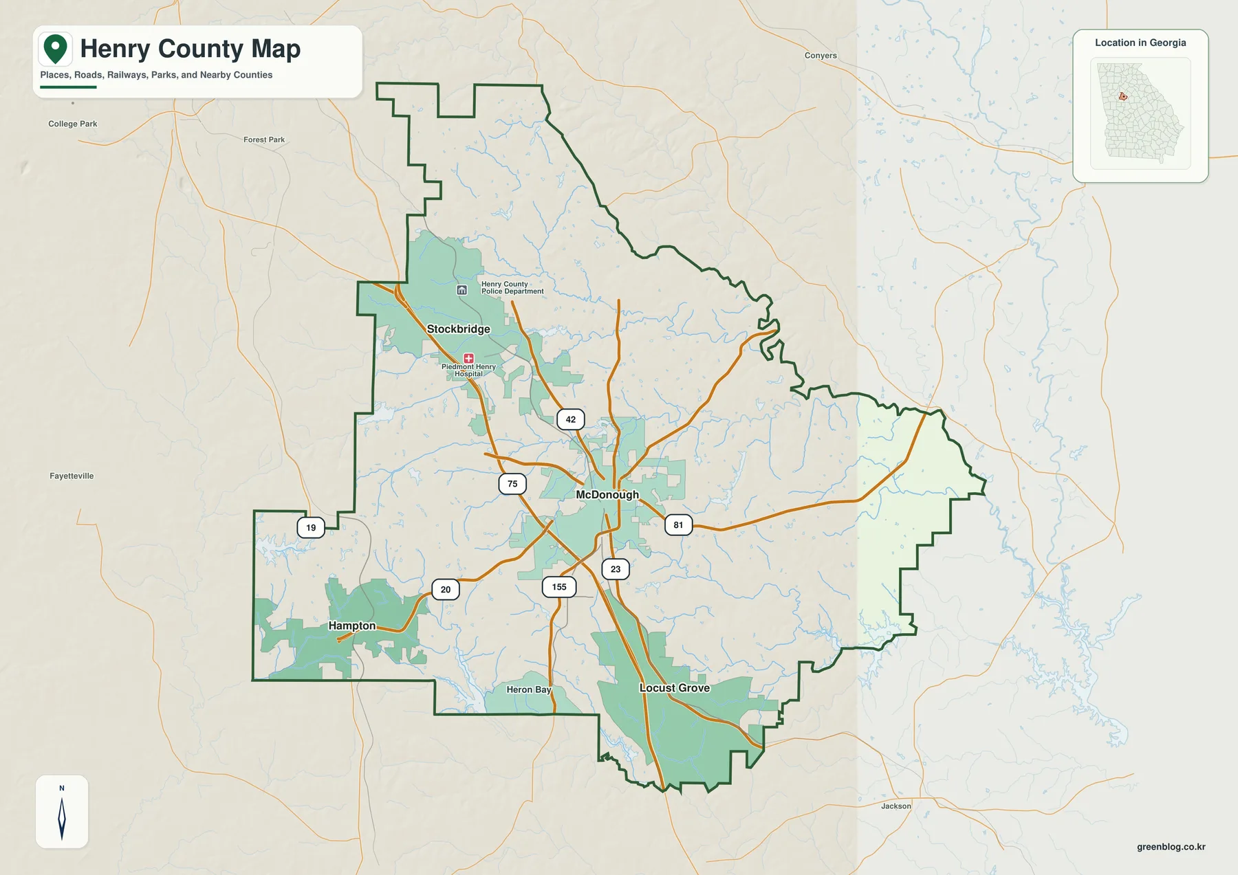
Interstate 75 is the most prominent transportation line on the map. It passes through the Stockbridge–McDonough corridor and continues south toward Locust Grove, creating a clear north-south reference through the developed western-central part of the county. Stockbridge is marked near the Henry County Police Department and Piedmont Henry Hospital, which make the northwestern urban area easy to recognize. McDonough forms another large developed area farther southeast, where Routes 42, 155, 23, and 81 spread into different parts of the county.
Hampton occupies a separate southwestern urban area. Routes 19 and 20 help locate that side of the county, while Locust Grove remains close to I-75 farther south. Heron Bay is also labeled near the lower portion of the county. The distribution is therefore not a simple chain of four cities: Stockbridge, McDonough, and Locust Grove share a strong interstate relationship, but Hampton sits to the west and depends on a different set of roads for local access.
Places outside the county, including Conyers, Forest Park, College Park, Fayetteville, and Jackson, provide regional orientation around the map. Numerous thin blue streams cross the county between the roads and developed areas, especially toward the east and south. They matter because they show that the land between suburban centers is divided by many small valleys. The general map works best as a first overview before the water and elevation views isolate those natural features in greater detail.
Straight-Line City Connections from Stockbridge
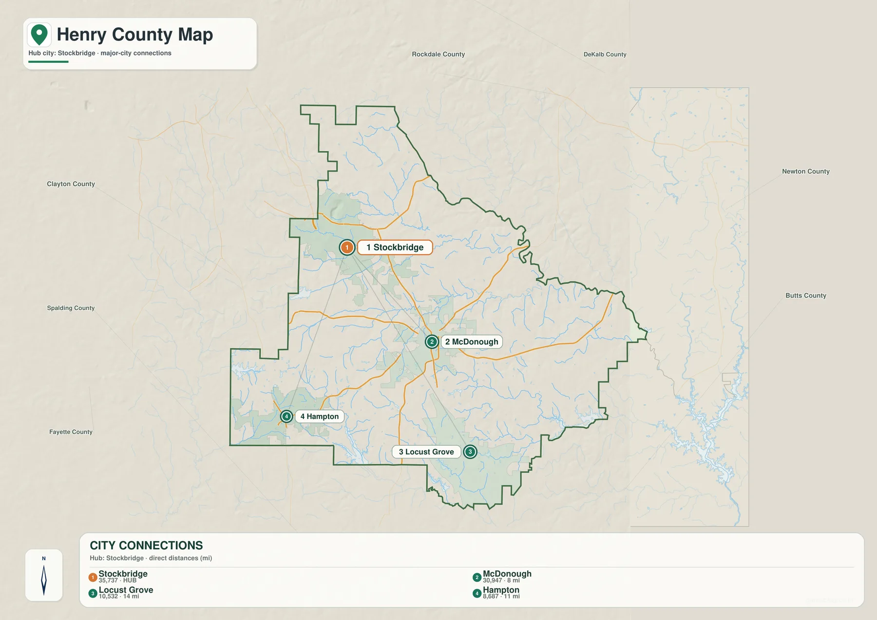
The city-connections graphic simplifies Henry County to four major city references. Its CITY CONNECTIONS panel lists Stockbridge at 35,737, McDonough at 30,947, Locust Grove at 10,532, and Hampton at 8,687. Those figures are the values printed on the supplied map and are included here to explain the graphic’s ranking, not as newly verified population estimates. Readers who need current official demographic figures should use the Census QuickFacts source in the reference section.
The connector labels show McDonough about 8 miles from Stockbridge, Hampton about 11 miles away, and Locust Grove about 14 miles away. These are straight-line distances rather than driving mileage. Actual travel can be longer because road routes curve through the county and the exact start and end points vary. Even so, the comparison makes the layout easy to understand: McDonough is the closest major southeastern connection, Hampton lies southwest, and Locust Grove is farther south.
Clayton, Spalding, Rockdale, DeKalb, Newton, Butts, and Fayette counties are labeled around the frame for regional orientation. Stockbridge sits close to the northwestern side facing the Clayton and DeKalb direction, while Locust Grove is much closer to the southern Butts County side. McDonough occupies a more central position within Henry County, which helps explain why it remains a useful county-seat reference even though Stockbridge has the largest displayed value on this particular city graphic.
| Place | Displayed value | Straight-line distance from Stockbridge | General position |
|---|---|---|---|
| Stockbridge | 35,737 | hub | northwest |
| McDonough | 30,947 | about 8 mi | southeast |
| Hampton | 8,687 | about 11 mi | southwest |
| Locust Grove | 10,532 | about 14 mi | south |
South River, Towaliga River, and Henry County’s Creek Network
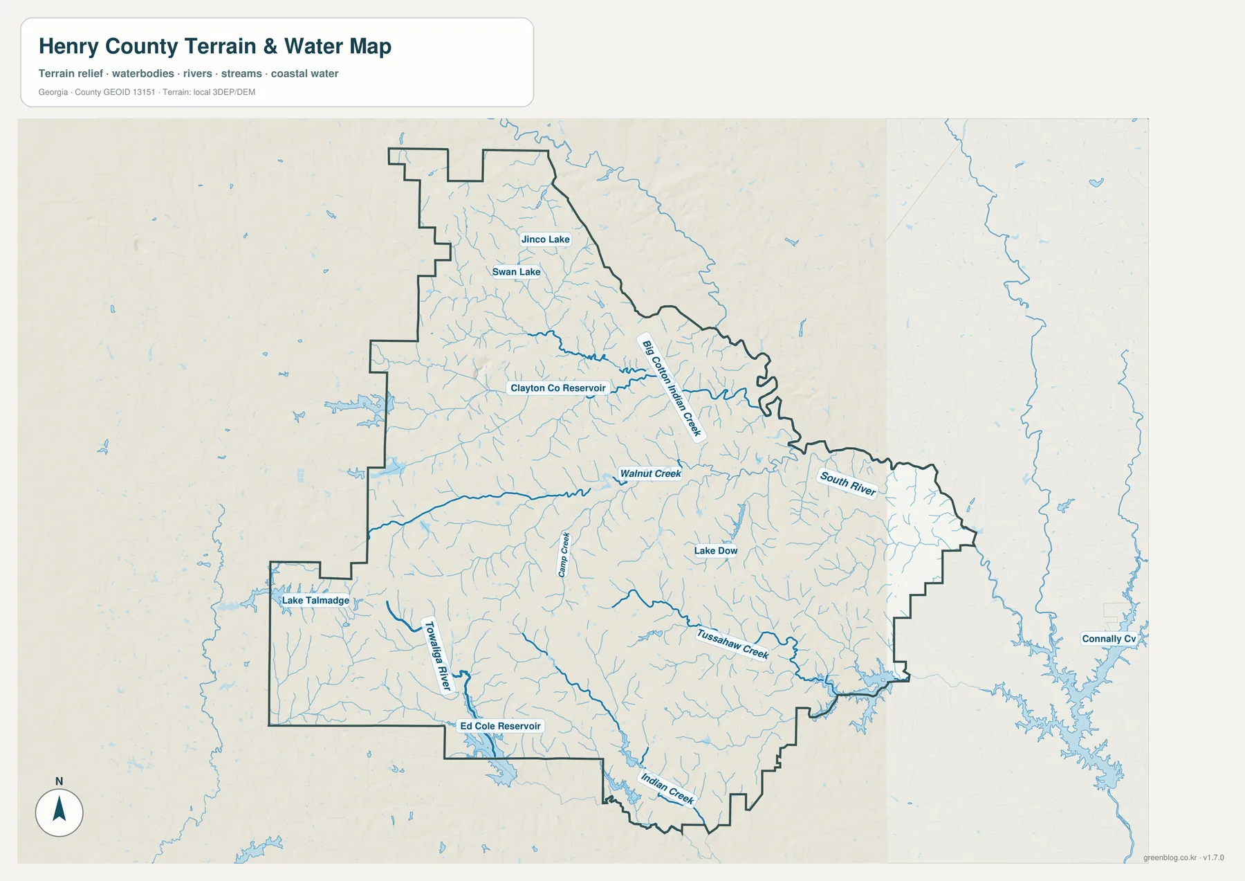
The water map gives Henry County a much more intricate structure than the road view. Big Cotton Indian Creek is a major named channel in the northern interior, while Walnut Creek crosses the central part of the county. South River is labeled along the eastern side and follows one of the broadest low corridors on the map. Many smaller tributaries join these waterways, creating a dense drainage network beneath the suburban and rural land shown on the general reference map.
Farther south and west, Towaliga River becomes a strong named feature. Tussahaw Creek occupies a long southeastern valley, Indian Creek reaches the southern county edge, and Camp Creek provides another central reference. These channels divide the space between McDonough, Hampton, and Locust Grove into many smaller valleys. The pattern is useful for understanding why roads bend and why low terrain often appears in narrow bands rather than one continuous plain.
Several named lakes and reservoirs add local reference points. Jinco Lake and Swan Lake appear in the northern county, with Clayton Co Reservoir farther south. Lake Dow is labeled east of the center, Lake Talmadge lies in the southwestern section, and Ed Cole Reservoir appears near the southern edge. Conally Cove is visible outside the eastern county boundary and is best treated as surrounding-area context. These named waters are not equal in size or purpose; they simply help readers locate parts of a very dense stream network.
This map is intended for county-scale water orientation. It does not determine flood status for a parcel, private-property limits, water depth, or access conditions. Those questions require current specialized records. For ordinary map reading, the useful relationships are Big Cotton Indian Creek and Walnut Creek across the northern and central county, South River along the lower eastern terrain, and the Towaliga–Tussahaw–Indian Creek system through the southern half.
Elevation from About 95 to 301 Meters
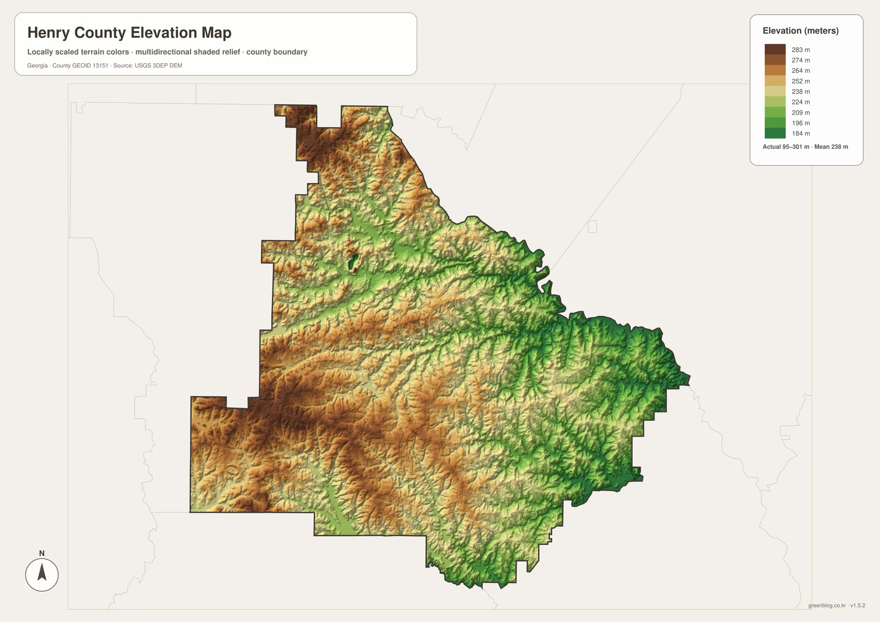
The supplied elevation map reports an actual range of approximately 95 to 301 meters, with a mean of 238 meters. Higher tan and brown terrain is concentrated across much of the west and northwest, while greener lowlands become more common toward the east and southeast. A difference of more than 200 meters between the mapped low and high points is substantial enough to create a clear rolling landscape rather than a uniformly flat suburban county.
The low terrain aligns closely with the water network. South River occupies a long green corridor near the eastern side, and the Tussahaw Creek valley forms another lower route through the southeast. Big Cotton Indian Creek and Walnut Creek also follow narrow green cuts between higher ridges. Comparing the two maps shows that the tributaries generally occupy the lowest paths through the county rather than crossing the higher hills at random.
The western and southwestern interior is more strongly rolling. Towaliga River and smaller tributaries cut lower channels through those hills, while Stockbridge sits near some of the higher northwestern terrain. McDonough lies in mixed middle elevations between the higher west and the lower eastern drainage. South of Locust Grove, rolling ridges and creek valleys continue to alternate. Henry County is therefore better described as a network of low drainage corridors between hills than as a simple eastward slope.
The relief colors are designed for broad county comparison, not for determining the exact elevation of a building lot, road project, drainage design, or property survey. Site-level work needs finer elevation data and, when appropriate, field measurements. For classroom geography, local research, or presentations, the 95–301 meter range clearly shows the higher western terrain and the lower South River and southeastern creek valleys.
I-75 Suburban Growth and the McDonough-Centered County
The source material in the package states that Henry County was established in 1821 and identifies Interstate 75, logistics, housing growth, commuting, and regional services as major parts of its suburban-development context. The maps here do not measure freight volume, housing construction, or commuting totals. Instead, they provide the geography beneath those subjects: Stockbridge, McDonough, and Locust Grove along the I-75 side, Hampton to the southwest, numerous stream valleys crossing the developed areas, and rolling relief between about 95 and 301 meters.
The general county map is the best starting point when cities, roads, and the boundary all matter. The Stockbridge-centered city view gives a cleaner comparison of McDonough, Hampton, and Locust Grove. The water map is the stronger reference for South River, Big Cotton Indian Creek, Walnut Creek, Towaliga River, Tussahaw Creek, and named reservoirs, while the elevation map explains why those waterways occupy lower corridors between hills.
McDonough ties the four themes together. Major numbered roads spread from the city, Stockbridge lies about 8 straight-line miles to the northwest, and the I-75 corridor links the central urban area with Locust Grove to the south. Moving east from McDonough brings the South River side and lower terrain closer, while moving west reaches higher rolling ground and the Hampton side. Those relationships show Henry County as a connected suburban county shaped not only by highways and cities but also by a dense network of creeks and ridges.
Frequently Asked Questions
Which city is the Henry County seat?
McDonough is the county seat. The city-connections map uses Stockbridge as its hub only to compare straight-line distances with McDonough, Hampton, and Locust Grove.
Are the 8-, 11-, and 14-mile labels driving distances?
No. The graphic shows straight-line distances from Stockbridge: about 8 miles to McDonough, 11 miles to Hampton, and 14 miles to Locust Grove. Road mileage depends on the route and exact endpoints.
Which waterways are named on the water map?
Big Cotton Indian Creek, Walnut Creek, South River, Towaliga River, Tussahaw Creek, and Indian Creek are among the clearest labels. The map also identifies Jinco Lake, Swan Lake, Lake Dow, Lake Talmadge, Clayton Co Reservoir, and Ed Cole Reservoir.
What is included in the downloadable A3 ZIP?
The archive contains four large JPG originals covering the general county reference, Stockbridge-centered city connections, waterways, and elevation. Keeping those subjects in separate files makes roads, city relationships, water labels, and relief easier to read when printed or placed in a document.
Map File Information
Henry County A3 Map Files
- Included Files: 4 high-resolution A3 JPG map files shown in this article
- File Type: JPG files in a ZIP archive
- Intended Use: Printing, education, presentations, and map-based projects
Related Maps
Henry County Data and Map References
- U.S. Census Bureau QuickFacts: Henry County – current official county statistics
- New Georgia Encyclopedia: Henry County – county history and regional background
- New Georgia Encyclopedia: McDonough – local background on the county seat
- Census TIGER/Line boundary resources – Henry County and neighboring-county reference geometry
- USGS hydrography resources – reference data for the South River, creeks, lakes, and reservoirs
- USGS 3DEP elevation resources – source elevation data for comparing the 95–301 meter terrain range
Green Map creates custom-edited map images using open geographic data sources such as geoBoundaries, Natural Earth, OpenStreetMap, and government open data. These maps are edited visual materials, not raw data files, and are provided for education, documents, presentations, and graphic reference.