Saline County sits near the center of Kansas, with Salina forming a much larger urban and transportation center than the surrounding communities. Interstate 70 crosses the northern side of the city, and Interstate 135 runs south through the county toward Assaria and Bridgeport. The Saline River, Smoky Hill River, and Gypsum Creek create broad low corridors, while higher terrain dominates much of the west and southwest. High-resolution map files are available for download in the section below.
This guide follows Salina, Assaria, Gypsum, Brookville, Smolan, and New Cambria across the road, water, and elevation views. Terrain ranges from about 349 to 505 meters. WebP previews are available for quick viewing, and the matching high-resolution JPG files can be downloaded together in one ZIP for printing, classroom work, or offline reference.
Table of Contents
Salina anchors the county at the I-70 and I-135 crossroads
Salina sits slightly east of the county center and is the dominant transportation reference. Interstate 70 crosses the northern side of the urban area, while Interstate 135 and US 81 continue south through the county. K-143 serves the northern side of Salina, K-140 reaches west toward Brookville, and K-104 provides an important route toward the southeastern rural area.
Saline County’s official website identifies Salina as the county seat and largest city. The Kansas Historical Society also records Salina as the county seat and notes the importance of railroads, wheat, flour milling, and later military activity in the county’s development.
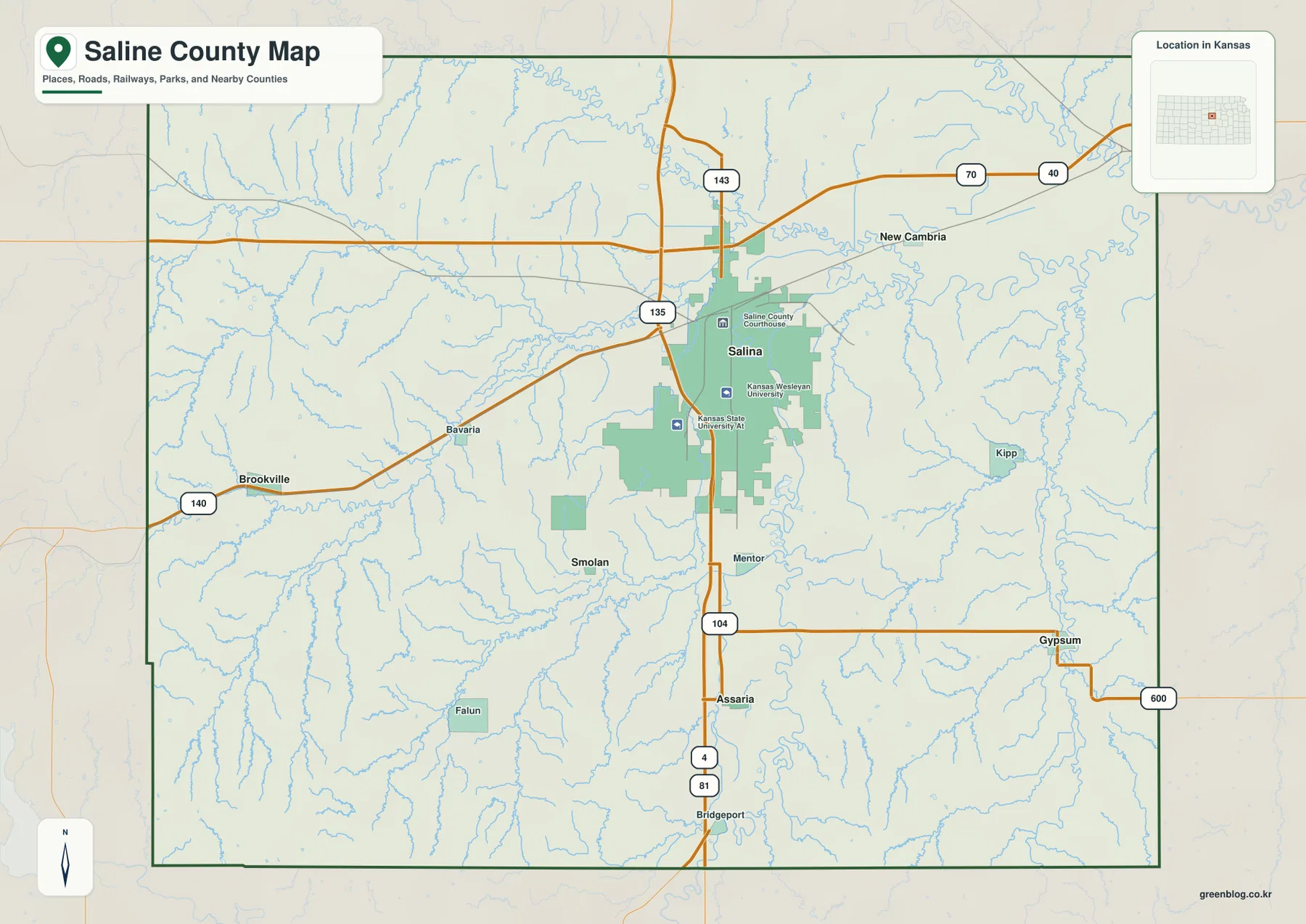
Brookville lies west of Salina near K-140, while Smolan sits in the southwestern rural area. Assaria follows the I-135 and US 81 corridor south of Salina, and Gypsum is farther southeast. New Cambria lies northeast of the urban area where roads, rail lines, and lower river terrain begin to spread into the eastern county.
Salina dominates the six-city index
The city panel ranks Salina at 46,307. Assaria follows at 521, Gypsum at 443, Brookville at 197, Smolan at 148, and New Cambria at 144. These are map index values rather than current official population estimates, but they clearly show the scale difference between Salina and the smaller communities.
The smaller cities occupy very different settings. Assaria is tied to the southern interstate corridor, Gypsum lies among southeastern stream valleys, Brookville marks the western side, and New Cambria occupies the northeastern edge of the Salina area.
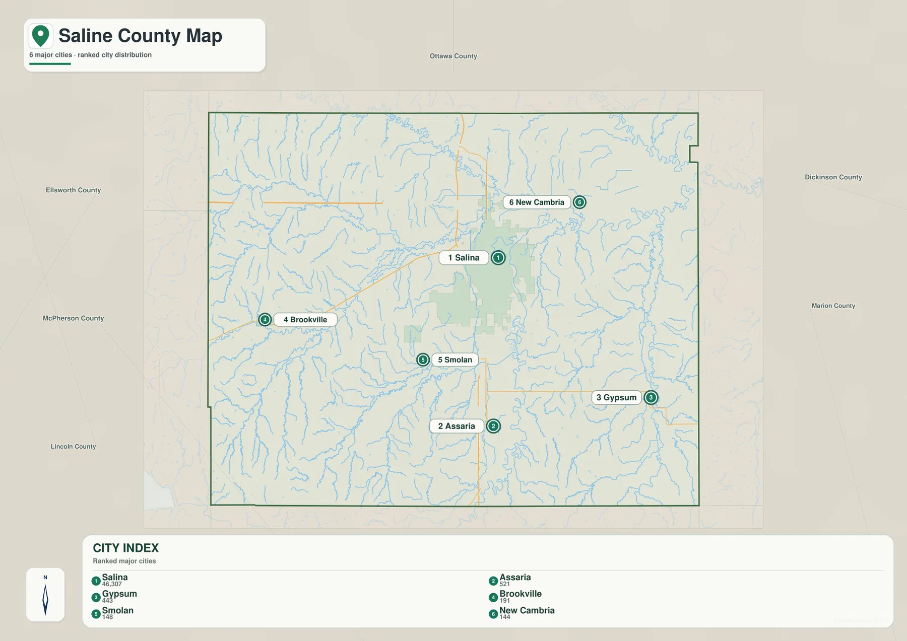
Saline County’s official site lists these same six incorporated cities. The county’s official census population figures and the supplied map index are different datasets and should not be treated as interchangeable, but both show Salina as the overwhelming population and service center.
The Saline and Smoky Hill rivers create two major lowland corridors
The Saline River is the strongest water feature across the northern part of the county. It bends eastward through the north-central landscape and collects many smaller tributaries. The county itself was named for this river.
Farther east, the Smoky Hill River forms another major low corridor around the eastern and northeastern side of Salina. The Solomon River also appears near the northeastern edge, while Gypsum Creek runs north through the southeastern county toward the larger river network.
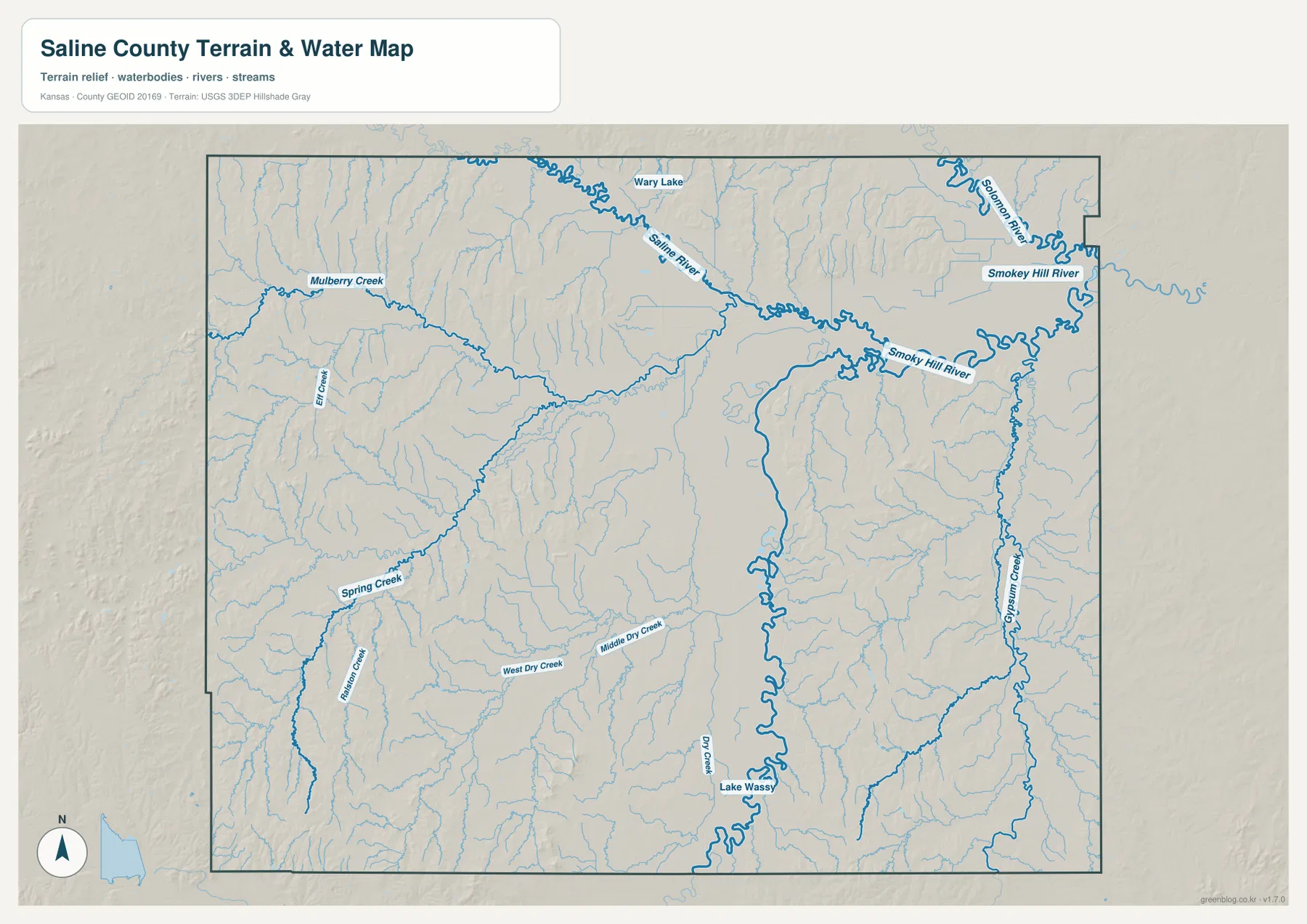
Mulberry Creek cuts a long valley across the western side, while Elm Creek descends from the northern uplands. In the southwest, Spring Creek and Running Creek divide higher terrain. West Dry Creek and Middle Dry Creek create additional low corridors across the south-central county, and Lake Wassy and Wary Lake provide smaller local water references.
The county therefore does not revolve around a single drainage line. The Saline River, Smoky Hill River, and Gypsum Creek each shape different parts of the map, while smaller western streams cut much narrower valleys through the uplands.
This water image is intended for geographic reference rather than floodplain, navigation, water-quality, parcel, or legal-access decisions. Water levels and stream conditions can change, so current agency information should be used whenever access or safety matters.
Elevation from 349 to 505 meters rises sharply toward the west and southwest
The elevation surface ranges from about 349 to 505 meters, with a mean near 403 meters. Brown and tan high ground dominates much of the west and southwest, while greener low terrain becomes more extensive around Salina, the Saline River, the Smoky Hill River, and the eastern county.
Brookville and the Falun side lie closer to higher uplands cut by narrow streams. East of Salina, the Smoky Hill River occupies broader connected low ground, and Gypsum Creek creates another long lower valley in the southeast.
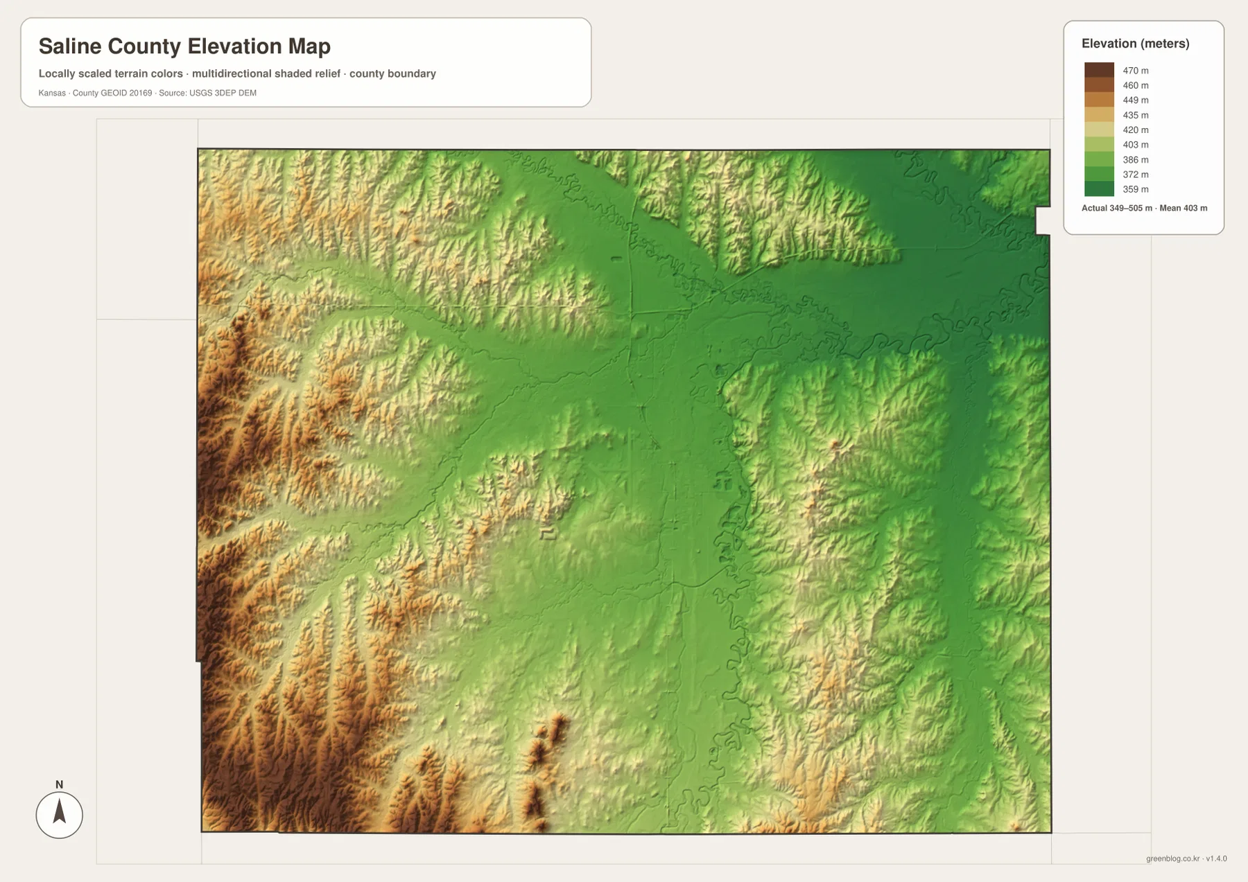
The Kansas Historical Society places Saline County in the Smoky Hills and Flint Hills Uplands physiographic regions. That description matches the supplied relief image, where rougher western hills transition toward lower river country in the east and northeast.
The elevation surface is generalized for county-scale comparison. It is not survey-grade or engineering-grade measurement and should not be used for parcel elevations, construction grades, drainage design, or legal boundary work.
Indian Rock Park gives a local view over Salina and the Smoky Hill River
The City of Salina describes Indian Rock Park as a 35-acre park on Gypsum Avenue with nature trails, prairie grass, a small pond, and an overlook toward Salina and the Smoky Hill River. The park gives a useful real-world reference for the same city-and-river relationship visible on the county maps.
That overlook is especially helpful for understanding why the Salina area is not simply flat urban land. Low river terrain sits close to short hills and ridges, creating visible relief within and around the city.
Salina’s universities and former military facilities reflect its regional importance
The Kansas Historical Society notes that Kansas Wesleyan University was established in 1886 and that Saline County later hosted Camp Phillips and Smoky Hill Army Airfield during World War II. The airfield was later renamed Schilling Air Force Base and remained active until the mid-1960s.
The general map also shows Kansas Wesleyan University and Kansas State University Salina within the urban area. Education, transportation, and the county’s military history all help explain why Salina grew into a regional center far larger than the surrounding towns.
Traveling from Brookville through Salina toward Gypsum reveals the county’s terrain change
Approaching Salina from Brookville along K-140 means leaving higher western ground and entering a broader urban lowland. Continuing southeast toward Gypsum brings the route closer to the Smoky Hill River and Gypsum Creek system, where lower terrain becomes more extensive.
The southern comparison is different. Assaria and Bridgeport are easy to locate along I-135 and US 81, while Smolan lies farther west among rolling rural terrain and many small tributaries. Following these road corridors alongside the water and elevation views makes the county’s internal differences much clearer.
For posters, classroom prints, or presentation slides, use the original JPG files in the download archive rather than enlarging the web previews. Small road labels, creek names, town text, and the elevation legend remain clearer at the higher resolution.
Frequently Asked Questions
Which city is largest on the supplied city index?
Salina ranks first at 46,307. Assaria is 521, Gypsum 443, Brookville 197, Smolan 148, and New Cambria 144. These are map index values rather than current official population estimates.
Are the Saline River and Smoky Hill River the same river?
No. The Saline River crosses the northern part of the county, while the Smoky Hill River forms a separate major lowland east and northeast of Salina. Gypsum Creek and many smaller tributaries feed the broader drainage network.
Can the 349–505 meter elevation image be used for surveying?
No. It is a generalized county-scale terrain image for comparing higher western uplands with lower river and creek valleys. Parcel elevations, engineering grades, drainage design, and legal boundary work require more precise official data and, where needed, professional surveying.
Map File Information
The archive contains the Saline County, Kansas general county map, city map, terrain-and-water map, and elevation map as original high-resolution JPG files.
- Included Files: Use only the versions confirmed in the article and supplied images
- File Type: Use the confirmed download contents
- Intended Use: Printing, education, presentations, and map-based projects
Related Maps
Sources and references
- Saline County, Kansas: About Us — county seat, city list, and county overview
- Kansas Historical Society: Saline County, Kansas — Saline River, physiographic setting, railroads, education, and military history
- City of Salina: City Parks & Playgrounds — Indian Rock Park and local park information
- U.S. Census Bureau TIGER/Line Shapefiles — county boundary and geographic reference data
- USGS National Hydrography — river and stream reference data
- USGS 3D Elevation Program — elevation and terrain reference data
Green Map creates custom-edited map images using open geographic data sources such as geoBoundaries, Natural Earth, OpenStreetMap, and government open data. These maps are edited visual materials, not raw data files, and are provided for education, documents, presentations, and graphic reference.