Geary County sits in north-central Kansas, where Junction City provides the clearest starting point for understanding settlements, highways, Milford Lake, the junction of the Republican and Smoky Hill rivers, and the Flint Hills terrain. Junction City is the county seat and largest city. Grandview Plaza lies immediately to the east, while Milford sits farther north near Milford Lake. The map files shown on this page are also available as high-resolution JPG downloads in one ZIP archive.
The county’s most distinctive natural feature is the river confluence near Junction City. The Republican River flows south from Milford Lake, the Smoky Hill River approaches from the west and southwest, and the two join near the Fort Riley–Junction City area to form the Kansas River. East and southeast of that lowland, Mt. Dowell Creek, Humboldt Creek, Clarks Creek, Dry Creek, and other tributaries cut deeply into the Flint Hills uplands.
The elevation surface ranges from about 312 to 472 meters with a mean near 385 meters. Low green terrain follows Milford Lake, the Republican River, the Smoky Hill River, and the Kansas River corridor, while higher orange and brown ridges dominate the eastern and southeastern county. The Kansas Historical Society identifies Geary County with the Flint Hills Uplands and highlights Junction City, Fort Riley, and the first territorial legislature at Pawnee as important parts of the county’s history.
Table of Contents
Junction City as the highway anchor for Geary County
The general county map makes Junction City the obvious orientation point. I-70 and U.S. 40 extend eastward across the county, K-18 connects the city area with the Fort Riley side, and U.S. 77 continues south through the lower half of the county. K-57 and K-244 help orient the northern route toward Milford and Milford Lake.
Grandview Plaza is so close to Junction City that the two urban areas appear nearly continuous on the county-scale map. Fort Riley occupies a broad area to the north and northeast, and Irwin Army Community Hospital is labeled inside the installation. Milford lies in the long northern section of the county, close to the lake and Republican River rather than the central highway corridor.
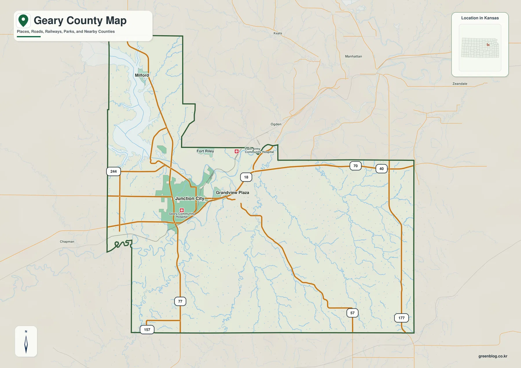
Geary County has an irregular outline that reflects its river valleys, lake shoreline, and historical boundary changes. The northern section follows the Milford Lake area, while the southeastern half spreads across heavily dissected Flint Hills. The western-central area around Junction City is much lower because of the large river valleys. This map is intended for county-scale orientation rather than live navigation, so current road work and access conditions around military property should be checked separately.
Junction City, Grandview Plaza, and Milford on the city connection map
The city connection map simplifies Geary County to three principal settlement references. Junction City is the hub, Grandview Plaza is shown about 2 miles away in a straight line, and Milford is about 11 miles away. These values communicate scale and direction rather than driving mileage, but they make the county’s settlement pattern immediately understandable.
The city ranking also places Junction City first, Grandview Plaza second, and Milford third. Junction City functions as the county’s administrative and service center, Grandview Plaza forms a small adjacent urban area, and Milford provides a northern community reference near the lake and Republican River. Linking each place with its nearby roads and natural features is more useful than treating the city names as an isolated list.
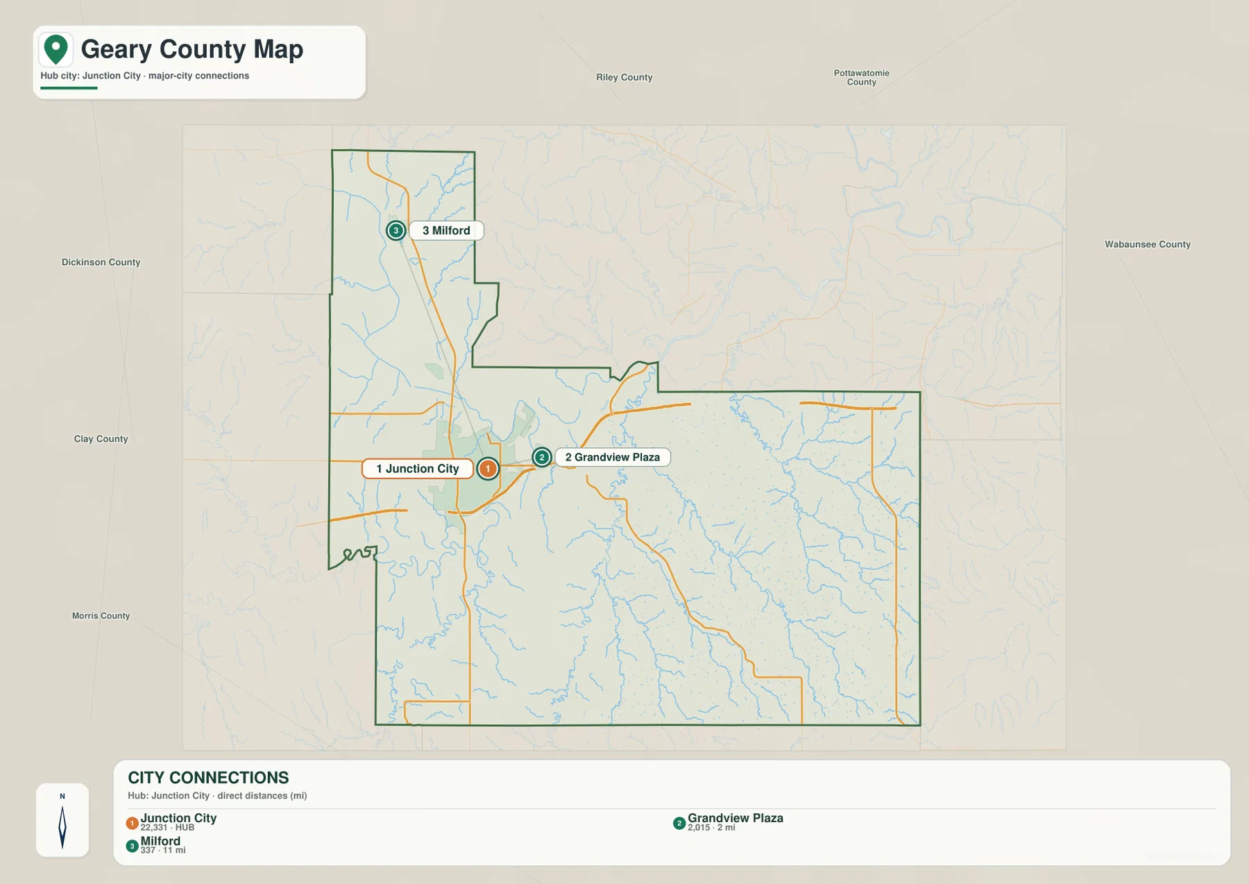
The Kansas Historical Society notes that Junction City became the county seat in 1860, and the current Geary County government remains based there. The official county website also links local resources for Grandview Plaza and Milford. The modern city pattern therefore matches the county’s long administrative geography, with Junction City remaining the primary center while smaller communities serve distinct parts of the county.
Where the Republican and Smoky Hill rivers become the Kansas River
The terrain and water map centers on one of the most important river junctions in Kansas. The Republican River descends from Milford Lake through the northwestern part of the county, while the Smoky Hill River approaches Junction City from the west and southwest. Near the Fort Riley–Junction City area, the two rivers meet and the downstream channel becomes the Kansas River.
The broad lowland around the confluence is much wider than most of the tributary valleys elsewhere in the county. Moon Lake is labeled nearby, and the Kansas River continues east below Fort Riley. The Kansas Historical Society links the name Junction City to this meeting of the Republican and Smoky Hill rivers, making the city’s name a direct reference to the local physical geography.
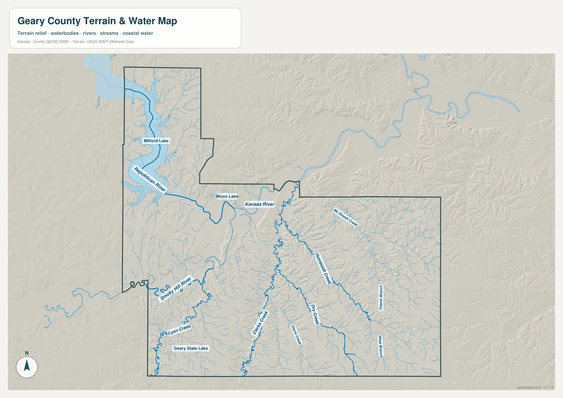
Farther south and east, Clarks Creek, Davis Creek, Dry Creek, Humboldt Creek, and Mt. Dowell Creek cut long narrow valleys through the uplands. Lyon Creek drains part of the southwest, and Geary State Lake is labeled nearby. Timber Branch and West Branch mark additional eastern drainage lines. These smaller valleys contrast sharply with the wide river lowland around Junction City.
Milford Lake and the Republican River corridor
Milford Lake is the largest water body shown within Geary County and occupies much of the long northern section. The Republican River narrows below the lake and runs south toward Junction City. Numerous small tributaries enter the reservoir and river from the surrounding hills, giving the shoreline an irregular shape and creating many local ridges between the inlets.
Milford sits close to this lake-and-river system, which makes it a useful northern reference on both the city and water maps. The surrounding land is lower than many of the Flint Hills ridges farther east, yet the reservoir margins are not uniformly flat. Tributary valleys and elevated divides create repeated changes in relief around the lake.
The terrain and water map is not a live source for reservoir level, flood warnings, boating conditions, or water quality. Anyone needing current conditions at Milford Lake or along the Republican River should use the latest information from the U.S. Army Corps of Engineers, USGS, or responsible local agencies. Here the purpose is to show how the lake and river fit into the wider county landscape.
A 312–472 meter contrast between river lowlands and Flint Hills ridges
The elevation map shows an actual range of approximately 312 to 472 meters and a mean elevation near 385 meters. The lowest green terrain follows Milford Lake and the Republican River southward into the Junction City area, then continues through the Smoky Hill and Kansas river lowlands. Junction City therefore sits close to one of the county’s broadest low-elevation zones.
The eastern and southeastern parts of Geary County are dramatically more rugged. Orange and brown ridges are cut by long green tributary valleys along Humboldt Creek, Clarks Creek, Dry Creek, and neighboring streams. The southwest also contains higher terrain, but the dense drainage pattern in the east makes the Flint Hills character especially visible there.
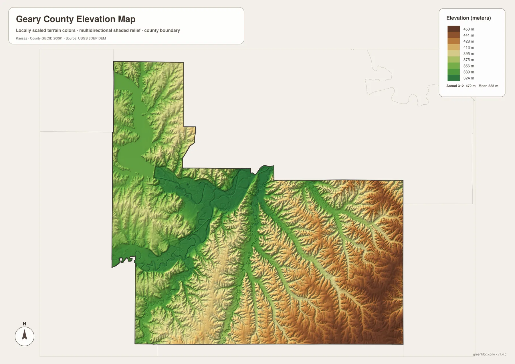
This elevation surface is intended for county-scale comparison rather than survey-grade measurement. It should not be used to establish exact parcel elevations, design drainage, or replace engineering and legal survey data. Its value is visual context: readers can see how Junction City occupies a major lowland while only a short distance east the terrain rises into closely dissected hills.
Fort Riley, Pawnee, and the geography of early Kansas
The Kansas Historical Society identifies Geary County as part of the Flint Hills Uplands and gives Fort Riley a central place in the county’s history. The military post began in the early 1850s and spans parts of Geary and Riley counties. On the map, Fort Riley lies immediately northeast of Junction City, close to the Kansas River and the Republican–Smoky Hill confluence.
The site of Pawnee near Fort Riley hosted the first Kansas territorial legislature in 1855. Although the legislature met there only briefly, the surviving First Territorial Capitol building remains an important historic site. These locations show why Geary County’s history cannot be separated from its transportation corridors and river geography: Fort Riley, Junction City, and early territorial routes all developed around the same central lowland.
Junction City itself takes its name from the meeting of the Republican and Smoky Hill rivers. That connection between a place name and a physical landform is unusually clear here. Military history, county administration, and the major rivers all occupy a relatively compact area, allowing the map set to connect human history with terrain without relying on abstract descriptions.
Choosing the right map for study or printing
For basic orientation, begin with Junction City and the I-70/U.S. 40 corridor, then add Grandview Plaza and Milford. For physical geography, trace the Republican River south from Milford Lake to its confluence with the Smoky Hill River, then follow the Kansas River eastward. The elevation view explains why that river junction forms such a broad lowland and why the eastern county becomes much more rugged.
The high-resolution JPG files in the ZIP are better suited than the reduced web previews for printing, classroom projects, local-history materials, and close inspection of labels. They are useful for county overviews and regional comparison, but current roads, military access, live water conditions, parcel boundaries, and exact elevations should always be checked against the latest authoritative sources when those details matter.
Frequently Asked Questions
Where is Junction City on the Geary County map?
Junction City sits in the western-central part of Geary County and serves as the county seat and largest city. I-70 and U.S. 40 provide the main east-west reference, U.S. 77 extends south, Grandview Plaza lies immediately east, and Milford is about 11 miles north in a straight line.
Where do the Republican and Smoky Hill rivers meet?
They meet in the lowland between the Junction City and Fort Riley area, and the downstream channel becomes the Kansas River. This confluence is one of the county’s defining geographic features and is closely connected with the name Junction City.
Can the 312–472 meter elevation map be used for surveying?
No. The elevation map is a county-scale visual reference for comparing river lowlands and Flint Hills uplands. Exact parcel elevations, construction design, drainage engineering, and legal surveys require purpose-built data and professional methods appropriate to those tasks.
Map File Information
Download the high-resolution JPG files corresponding to the Geary County general, city connection, terrain-and-water, and elevation maps in one ZIP archive.
- Included Files: Use only the versions confirmed in the article and supplied images
- File Type: Use the confirmed download contents
- Intended Use: Printing, education, presentations, and map-based projects
Related Maps
Sources and references
- Geary County, Kansas official website — county government and local community information
- Kansas Historical Society — Geary County, Kansas — Junction City, Fort Riley, Pawnee, Flint Hills Uplands, and county history
- U.S. Census Bureau TIGER/Line — boundary, road, and geographic data resources
- USGS National Hydrography — hydrography and stream-network data information
- USGS 3D Elevation Program — elevation data information
Green Map creates custom-edited map images using open geographic data sources such as geoBoundaries, Natural Earth, OpenStreetMap, and government open data.
These maps are edited visual materials, not raw data files, and are provided for education, documents, presentations, and graphic reference.