Franklin County lies in eastern Kansas, where Ottawa provides the clearest starting point for understanding settlements, highways, the Marais des Cygnes River valley, and the rolling Osage Cuestas. Ottawa is the county seat and the largest city, U.S. 59 runs north and south through the central area, and U.S. 50 and K-68 provide major east-west connections. Wellsville lies to the northeast, Pomona to the west, and Williamsburg, Princeton, and Richmond give the southern half several smaller reference points. High-resolution JPG versions of the maps can be downloaded together from the ZIP box below. High-resolution map files are available for download in the section below.
The Marais des Cygnes River is the county’s strongest natural landmark. It enters from the west, bends south of Ottawa, and continues east through a broad low corridor. Appanoose Creek, Eightmile Creek, Wolf Creek, Spring Creek, Walnut Creek, Pottawatomie Creek, and many smaller tributaries divide the surrounding hills. The elevation surface ranges from about 255 to 363 meters with a mean near 302 meters, clearly separating the central river lowland from higher western and southwestern ridges.
The Kansas Historical Society identifies Franklin County with the Osage Cuestas physiographic region and lists Ottawa as the county seat. The county was established in 1855, and Ottawa became the permanent seat after a series of nineteenth-century county-seat contests. That history fits the modern map well: Ottawa occupies a central location where major roads and the river valley come together, making it both an administrative and geographic anchor.
Table of Contents
Using Ottawa, U.S. 59, and K-68 to orient the county
Ottawa is the most prominent place on the general county map. U.S. 59 runs north and south through the city area, while K-68 approaches from Pomona in the west and continues eastward. U.S. 50 crosses the southwestern part of the county toward Ottawa, and I-35 passes diagonally through the southwest near Williamsburg. These routes create a simple framework before smaller rural roads and streams are added.
Pomona lies west of Ottawa along K-68, while Wellsville sits close to the northeastern boundary. Williamsburg is near I-35 in the southwest, Princeton lies south of Ottawa, and Richmond is farther south near the county line. Rantoul and Lane provide additional eastern references. The communities are separated by large rural spaces rather than one continuous urban corridor.
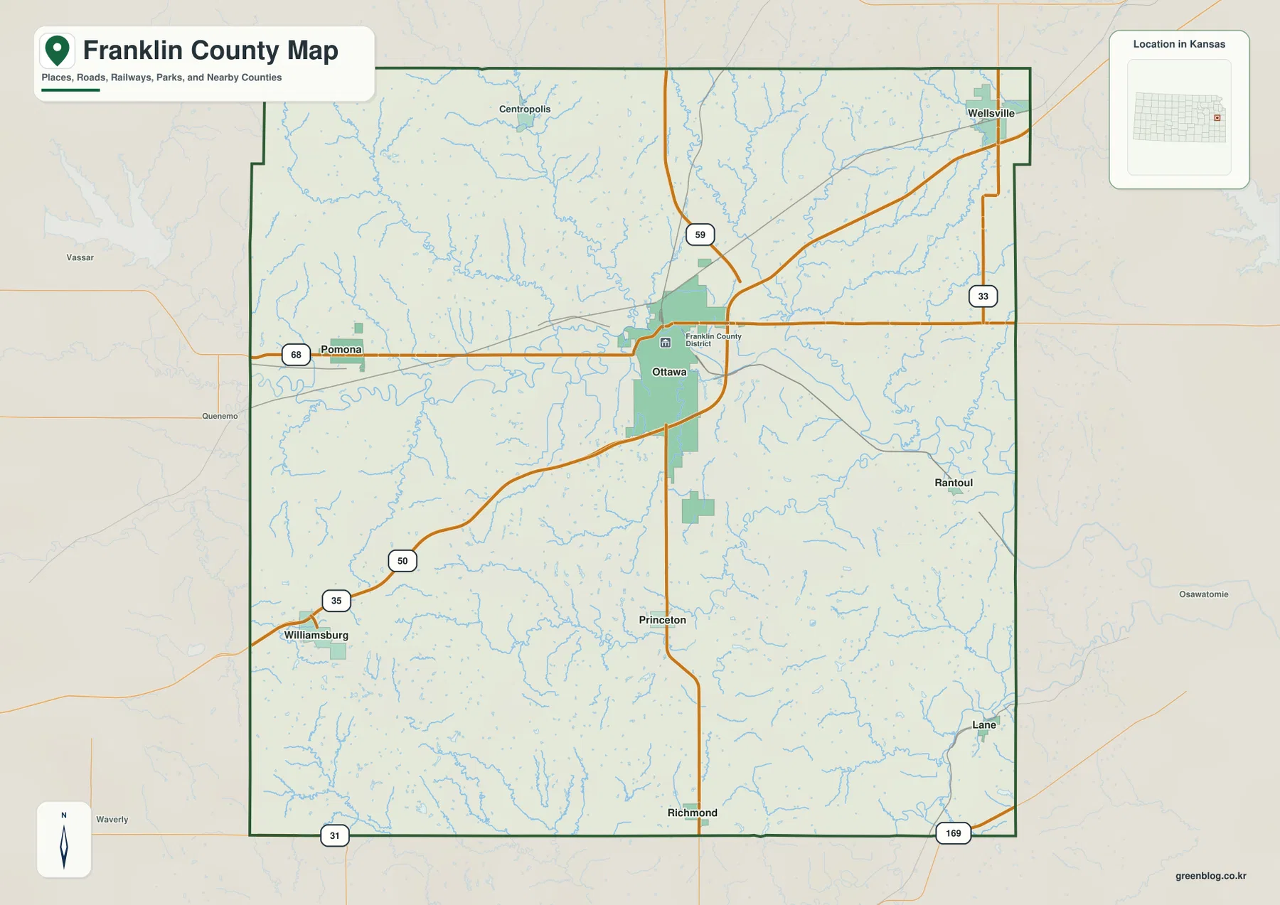
Roads become less dense away from Ottawa, while winding streams become more visually important across the western and southern countryside. Near the Marais des Cygnes River, roads repeatedly cross or bend around drainage corridors rather than following a perfect grid. The map is intended for county-scale orientation rather than live navigation, so current construction, flooding, winter weather, and road conditions should be checked through up-to-date sources.
Ottawa and the smaller communities spread across Franklin County
The city distribution map ranks Ottawa first, Wellsville second, and Pomona third. Richmond, Williamsburg, and Princeton are also marked as major community references. Ottawa dominates the urban pattern, while the remaining communities are widely separated near different highways and drainage areas. The result is a county with one clear center and several smaller rural service points rather than a chain of similarly sized towns.
Wellsville helps orient the northeastern corner toward Douglas and Miami counties, while Pomona marks the western K-68 corridor and the upper Marais des Cygnes area. Williamsburg is useful for the I-35 corridor in the southwest, and Richmond and Princeton divide the southern countryside into recognizable local areas. Learning those positions first makes the road and water maps much easier to read.
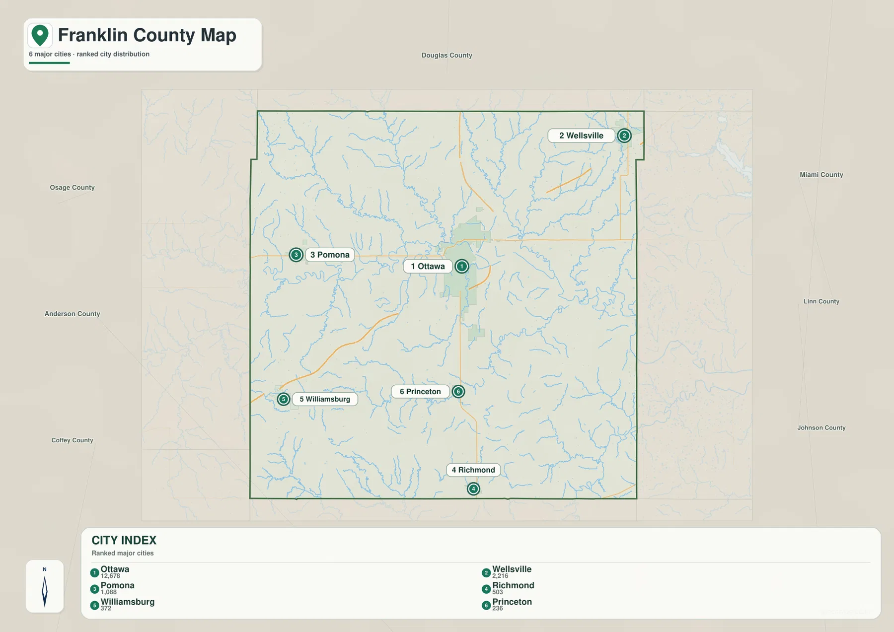
The Kansas Historical Society identifies Ottawa as both the county seat and the largest city, and the current Franklin County government is headquartered there. That administrative role matches the map pattern closely. Ottawa is not simply the biggest label; it is also the point from which the county’s highway, settlement, and river geography can be explained most efficiently.
The Marais des Cygnes River and its branching tributaries
The terrain and water map is organized around the Marais des Cygnes River. The river crosses the middle of Franklin County from west to east and occupies the broadest continuous low corridor. Appanoose Creek and Eightmile Creek descend toward the central valley from the northwest, while Wolf Creek, Spring Creek, and Walnut Creek drain the northeastern hills.
South of Ottawa, Hickory Creek and Rock Creek create additional valleys, and Middle Creek cuts across the southwestern interior. Pottawatomie Creek is a major southeastern reference. Natural Springs Lake appears near the north-central area, while Gilkey Lake and Richmond Lake are labeled in the south. Together these features show a dense drainage network rather than one isolated river channel.
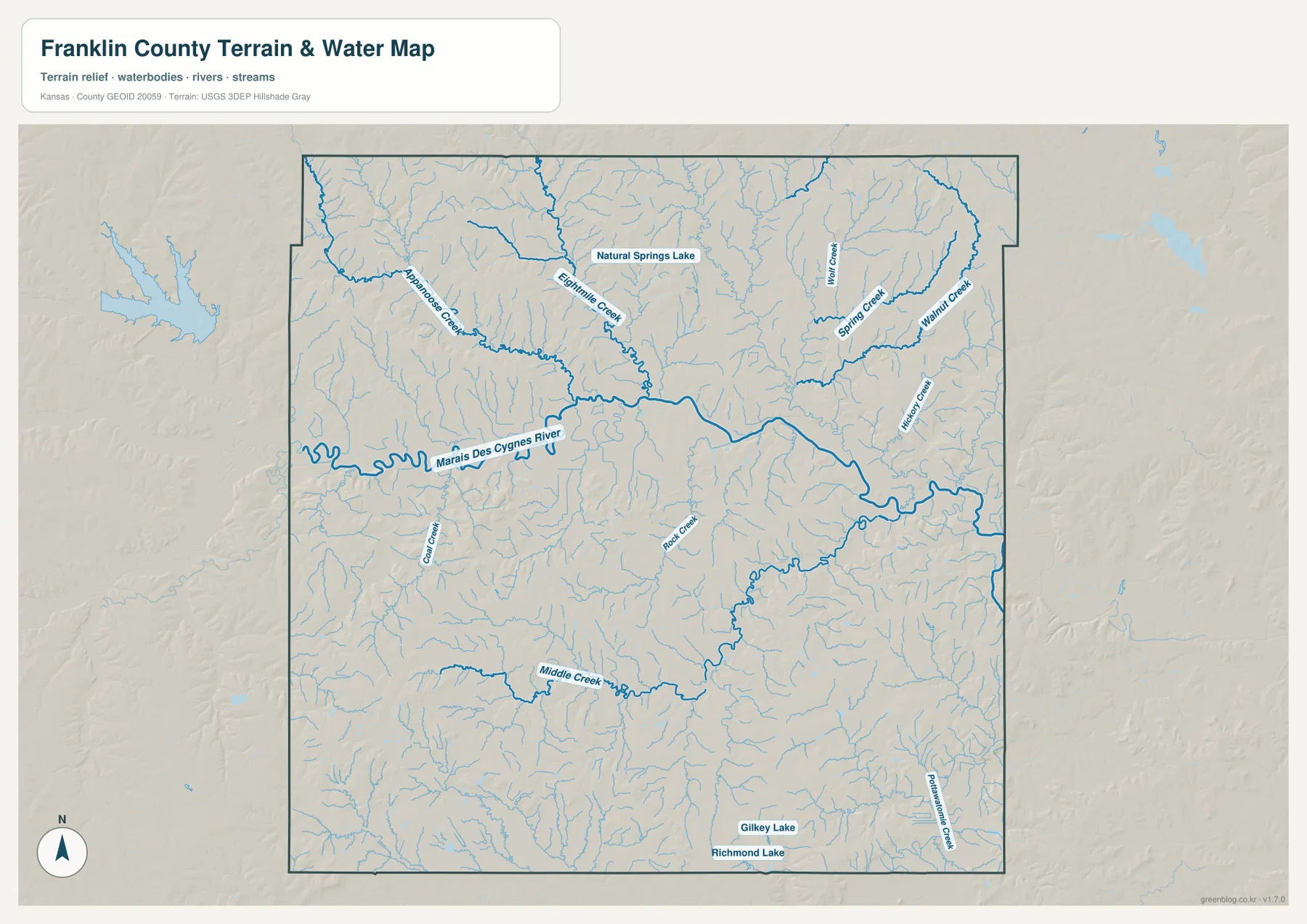
This is a geographic reference map, not a real-time flood or streamflow product. Franklin County contains many small tributaries and a broad river floodplain, so current water conditions should be checked with USGS or local emergency and water-management sources when flooding or river stage matters. Here, the water map is most useful for understanding where the valleys lie and how they divide the surrounding uplands.
A 255–363 meter landscape of river lowlands and cuestas
The elevation map shows an actual range of approximately 255 to 363 meters and a mean elevation near 302 meters. The lowest green terrain follows the Marais des Cygnes River across the middle of the county, especially south and east of Ottawa. Higher yellow, orange, and brown areas become more extensive toward the west and southwest.
Western Franklin County is strongly dissected by small streams, creating a dense pattern of ridges and narrow valleys. The Williamsburg area in the southwest also contains substantial higher ground. East of Ottawa, lower river and creek corridors remain prominent along Walnut Creek, Pottawatomie Creek, and related drainages. The county is not mountainous; its relief is better described as rolling, step-like uplands separated by stream valleys.
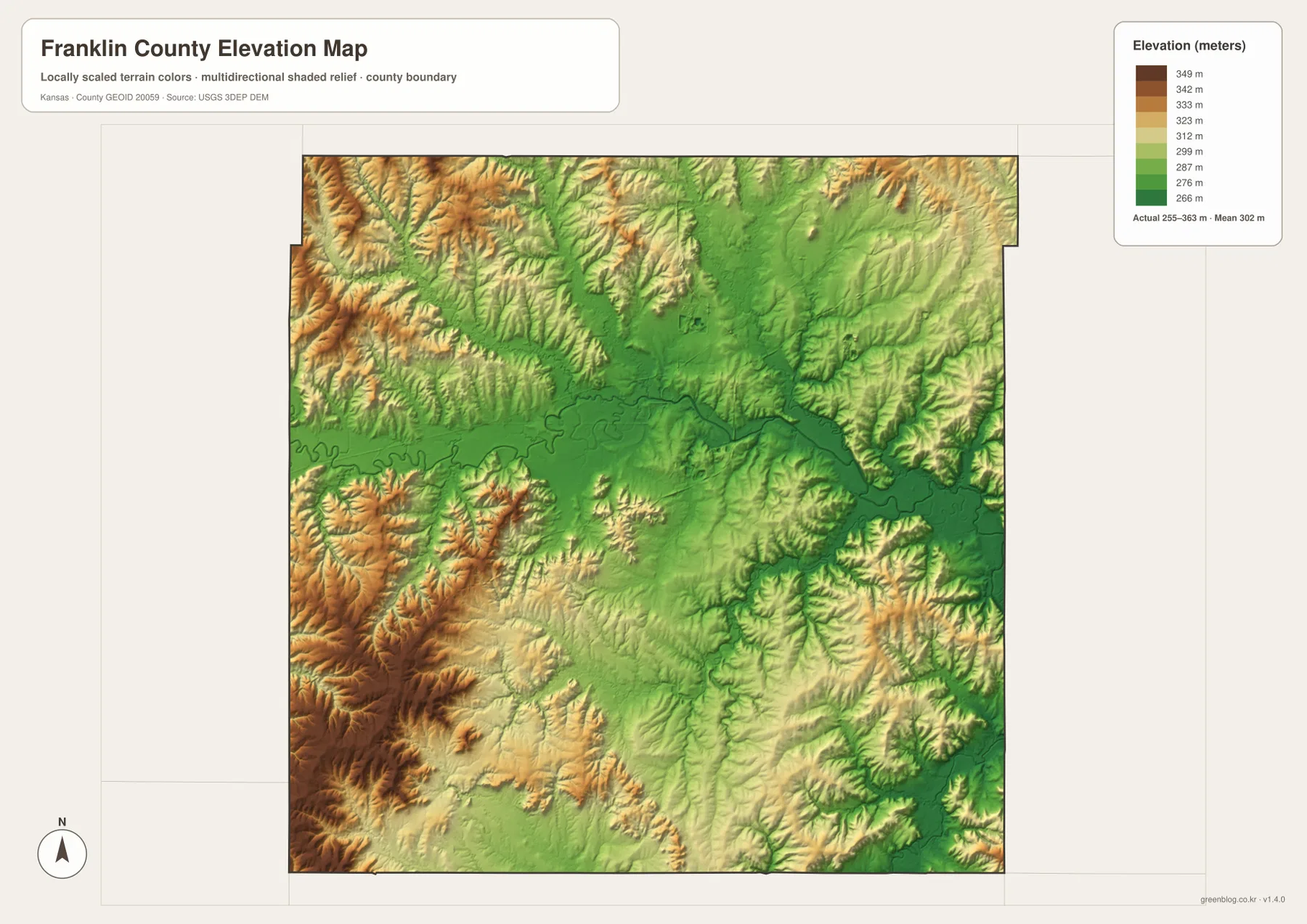
The elevation surface is intended for county-scale comparison rather than survey-grade measurement. It should not be used to establish exact parcel elevations, design drainage, or replace engineering and legal survey data. Its main value is visual context: Ottawa and the Marais des Cygnes valley occupy lower terrain, while the western and southwestern countryside rises into more strongly dissected uplands.
Osage Cuestas and Ottawa’s long role as the county center
The Kansas Historical Society describes Franklin County as part of the Osage Cuestas, a landscape of repeated ridges and valleys shaped by alternating rock layers. On the map, the geologic term is easier to understand by looking at the closely spaced upland ridges in the west and the lower stream corridors between them. The broad Marais des Cygnes valley cuts across that pattern and creates the county’s most important lowland.
Franklin County was established in 1855 and named for Benjamin Franklin. After several contested county-seat elections, Ottawa was finally selected as the county seat in 1864. The modern map reinforces that history because Ottawa remains the strongest transportation and administrative center, positioned close to the river and at the intersection of major routes.
The county’s smaller communities occupy different parts of the same landscape. Pomona sits along the western K-68 corridor, Wellsville provides a northeastern anchor, and Williamsburg, Princeton, and Richmond serve the southern rural area. The combination of settlements, roads, drainage, and relief makes Franklin County a useful example of how human geography follows natural corridors without being completely determined by them.
Choosing the right view for printing or study
For basic orientation, begin with Ottawa and U.S. 59, then add K-68, Pomona, Wellsville, and Williamsburg. For physical geography, follow the Marais des Cygnes River and compare its tributaries with the elevation map. The city distribution view is useful when the goal is to understand how one dominant center and several smaller communities are spaced around the county.
The high-resolution JPG files in the ZIP are better suited than the reduced web previews for printing, classroom projects, local-history materials, and close inspection of labels. They are useful for county overviews and regional comparison, but current roads, live stream conditions, parcel boundaries, and exact elevations should always be checked against the latest authoritative sources when those details matter.
Frequently Asked Questions
Where is Ottawa on the Franklin County map?
Ottawa sits slightly north of the county center and serves as both the county seat and largest city. U.S. 59 runs north and south through the area, while K-68 provides a strong east-west reference, making Ottawa the easiest first point for locating the rest of the county.
Why is the Marais des Cygnes River important on the map?
The Marais des Cygnes River forms the county’s largest continuous low corridor and crosses the central area from west to east. Numerous tributaries descend from the surrounding Osage Cuestas, and the elevation map shows the main river valley as distinctly lower than the western and southwestern uplands.
Can the 255–363 meter elevation map be used for surveying?
No. The elevation map is a county-scale visual reference for comparing uplands and valleys. Exact parcel elevations, construction design, drainage engineering, and legal surveys require purpose-built data and professional methods appropriate to those tasks.
Map File Information
Download the high-resolution JPG files corresponding to the Franklin County general, city distribution, terrain-and-water, and elevation maps in one ZIP archive.
- Included Files: Use only the versions confirmed in the article and supplied images
- File Type: Use the confirmed download contents
- Intended Use: Printing, education, presentations, and map-based projects
Related Maps
Sources and references
- Franklin County, Kansas official website — county government and local information
- Kansas Historical Society — Franklin County, Kansas — Ottawa, county history, and Osage Cuestas context
- U.S. Census Bureau TIGER/Line — boundary, road, and geographic data resources
- USGS National Hydrography — hydrography and stream-network data information
- USGS 3D Elevation Program — elevation data information
Green Map creates custom-edited map images using open geographic data sources such as geoBoundaries, Natural Earth, OpenStreetMap, and government open data.
These maps are edited visual materials, not raw data files, and are provided for education, documents, presentations, and graphic reference.