Barber County covers a broad part of south-central Kansas where Medicine Lodge serves as the clearest road and administrative anchor, while Kiowa, Hardtner, Sharon, Hazelton, Isabel, and Sun City are spread across a large rural area. The general map first draws attention to U.S. 160 and U.S. 281 around Medicine Lodge, but the terrain views add another layer: high, strongly dissected ground dominates much of the west and northwest, while the Medicine Lodge River corridor and the southeastern side sit noticeably lower. The four web maps on this page can be viewed online, and matching high-resolution JPG originals are available together in a downloadable ZIP.
Medicine Lodge and Kiowa make useful reference points because they represent different parts of the county. Medicine Lodge lies in the north-central to northeastern interior where U.S. 160 and U.S. 281 organize travel, while Kiowa sits close to the southeastern edge. Sun City and Lake City are much farther west in higher, rougher country, and Hardtner occupies the southern side along the U.S. 281 corridor. Sharon, Hazelton, and Isabel fill other parts of the eastern and northern map, so Barber County is better understood as a set of widely separated communities than as one continuous town-and-highway strip.
The official Barber County website identifies Medicine Lodge as the county seat and largest city and lists Kiowa, Sharon, Hardtner, Hazelton, Isabel, and Sun City among the incorporated communities. The same county overview notes the Medicine Lodge River and Elm Creek as major local waterways. Those details match the strongest features visible on the map set, making roads, settlements, drainage, and relief the most useful themes for understanding the county rather than treating the four images as a simple inventory.
Table of Contents
Medicine Lodge at the Meeting of U.S. 160 and U.S. 281
Medicine Lodge is the easiest place to locate on the general county map. Its built-up area is shaded clearly, U.S. 160 approaches from the west and continues toward Sharon, and U.S. 281 runs through the same part of the county on a north–south course. Those two highways give the road network a simple starting framework even though many smaller roads and stream lines fill the map. Once Medicine Lodge is fixed, the positions of the more distant communities become much easier to understand.
West of Medicine Lodge, Lake City and Sun City sit in the northwestern portion of the county where roads are more widely spaced and the terrain is more rugged. Eastward, U.S. 160 leads toward Sharon, while Hazelton and Kiowa occupy the southeastern side at different latitudes. Isabel is near the northern boundary, and Hardtner lies near the southern edge along the U.S. 281 corridor. The communities therefore do not form a single chain; they occupy separate parts of a county large enough that direction and road choice matter as much as town name.
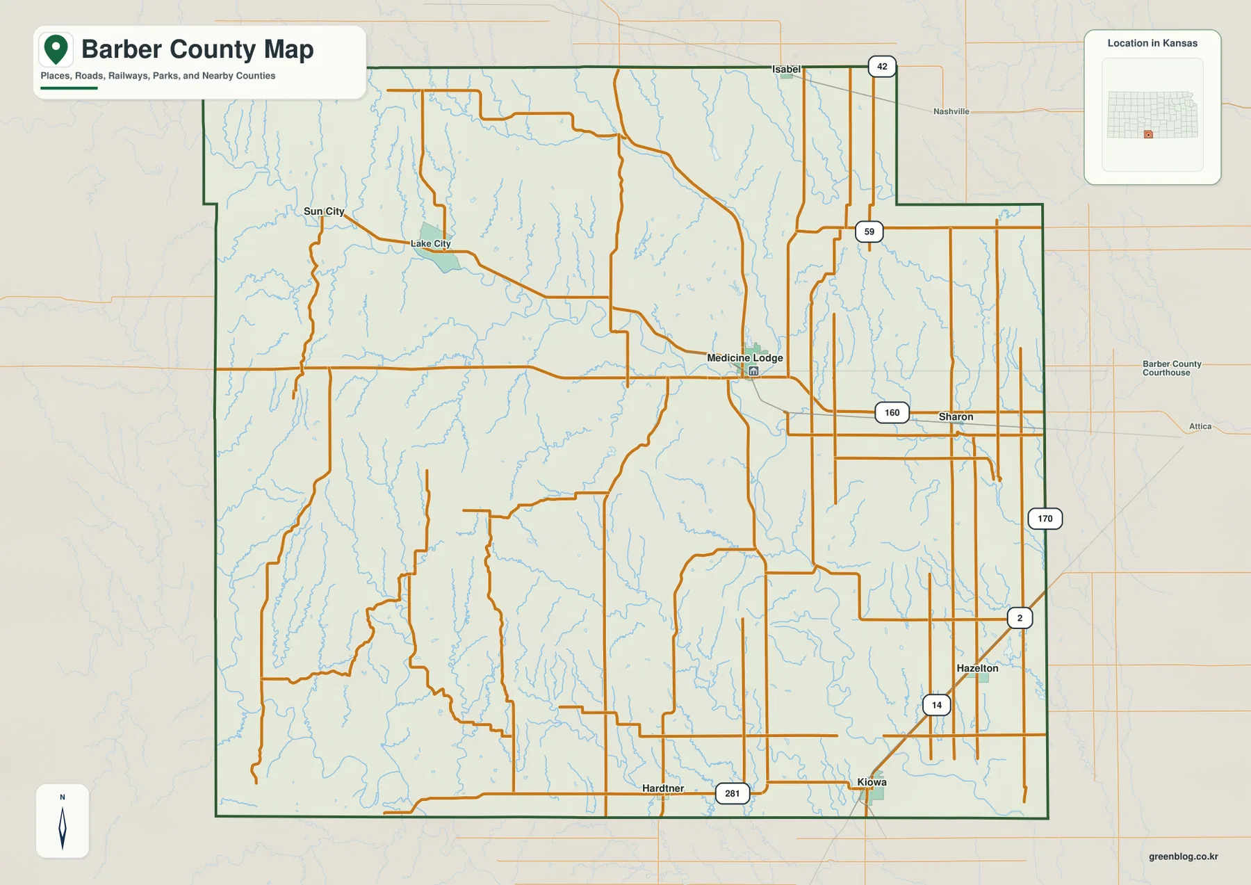
Additional route shields appear across the eastern side, including 59, 170, 2, and 14, while 42 is labeled near the northern edge. These secondary routes are especially helpful when reading the Sharon–Hazelton–Kiowa side of the county or orienting the Isabel area. Places outside the boundary, including Attica and Nashville, also provide useful context because they show the directions in which Barber County connects with surrounding parts of Kansas rather than leaving the county outline isolated on the page.
The general map also includes a dense background of thin blue stream lines. They are especially noticeable across the western and northwestern uplands, where short tributaries cut between ridges, but they recur throughout the southern half as well. That pattern is an early clue that the county is not a featureless plain. The specialized terrain-and-water view removes much of the road clutter and makes the named river and creek valleys easier to follow.
A Settlement Pattern Stretching from Sun City to Kiowa
The ranked city map simplifies Barber County to six principal communities. In the supplied index, Medicine Lodge is shown at 1,578, followed by Kiowa at 811, Hardtner at 216, Sharon at 173, Hazelton at 103, and Isabel at 93. These labels are best used as a visual comparison of relative prominence and spacing rather than as a substitute for a current official population estimate. Their main value is geographic: one can immediately see a larger Medicine Lodge center and a second substantial town at Kiowa, with much smaller communities spread far apart.
Medicine Lodge and Kiowa are the two largest entries on the map, yet they occupy different parts of the county. Medicine Lodge is in the north-central to northeastern interior, while Kiowa is close to the southeastern boundary. Hardtner sits near the southern edge, Sharon is east of Medicine Lodge along the U.S. 160 side, Hazelton is farther southeast, and Isabel is isolated near the north. This arrangement makes Barber County a good example of why a ranked settlement map is useful: the relative size pattern and the geographic spacing can be read without the visual competition of every local road.
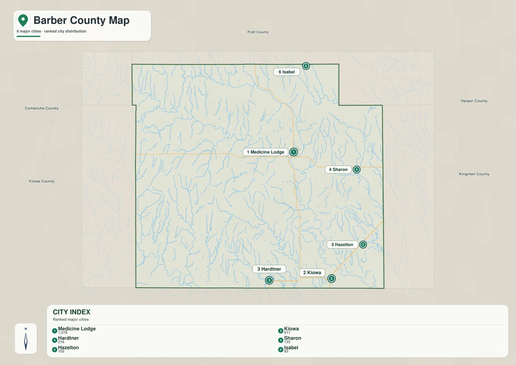
The surrounding county labels add regional orientation. Pratt County is to the north, Harper and Kingman Counties are to the east and northeast, and Comanche and Kiowa Counties are on the western side. For a larger Kansas county-map project, these labels make it easier to move from one county to the next without losing direction. They also explain why a place such as Kiowa relates to a very different edge of Barber County than Sun City or Lake City, even though all belong to the same county.
For real travel, settlement spacing should always be checked against the road map. The ranked city view shows where the communities are and how large they appear relative to one another, but it intentionally removes much of the road detail. U.S. 160 and U.S. 281 remain the most important first references, while the southeastern communities require attention to the additional state routes and local connections. Pairing the two maps prevents the common mistake of assuming that towns which look close on a simplified view are joined by one direct road.
Medicine Lodge River, Elm Creek, and a Branching Drainage Network
The terrain-and-water map makes the Medicine Lodge River the dominant hydrographic feature. It enters from the west, bends repeatedly across the central part of the county, and passes toward the Medicine Lodge area while collecting numerous short tributaries from higher ground on both sides. The river is drawn strongly enough to remain visible amid the dense network of smaller channels. Its broad valley also provides an important link between the water map and the elevation view because much of the same corridor appears as lower ground on the relief surface.
Elm Creek descends through the northeastern interior, and Sand Creek is labeled farther north. East Branch Little Sandy Creek and West Branch Little Sandy Creek occupy separate valleys on the eastern side, while Salty Creek and Spicer Lake appear toward the southeast. The southern half contains Little Mule Creek, Diamond Creek, Big Sandy Creek, and Lockard Creek, and Still Fork Arkansas River is labeled near the southwestern edge. Together these names show that Barber County is divided by many local drainage corridors rather than by one river alone.
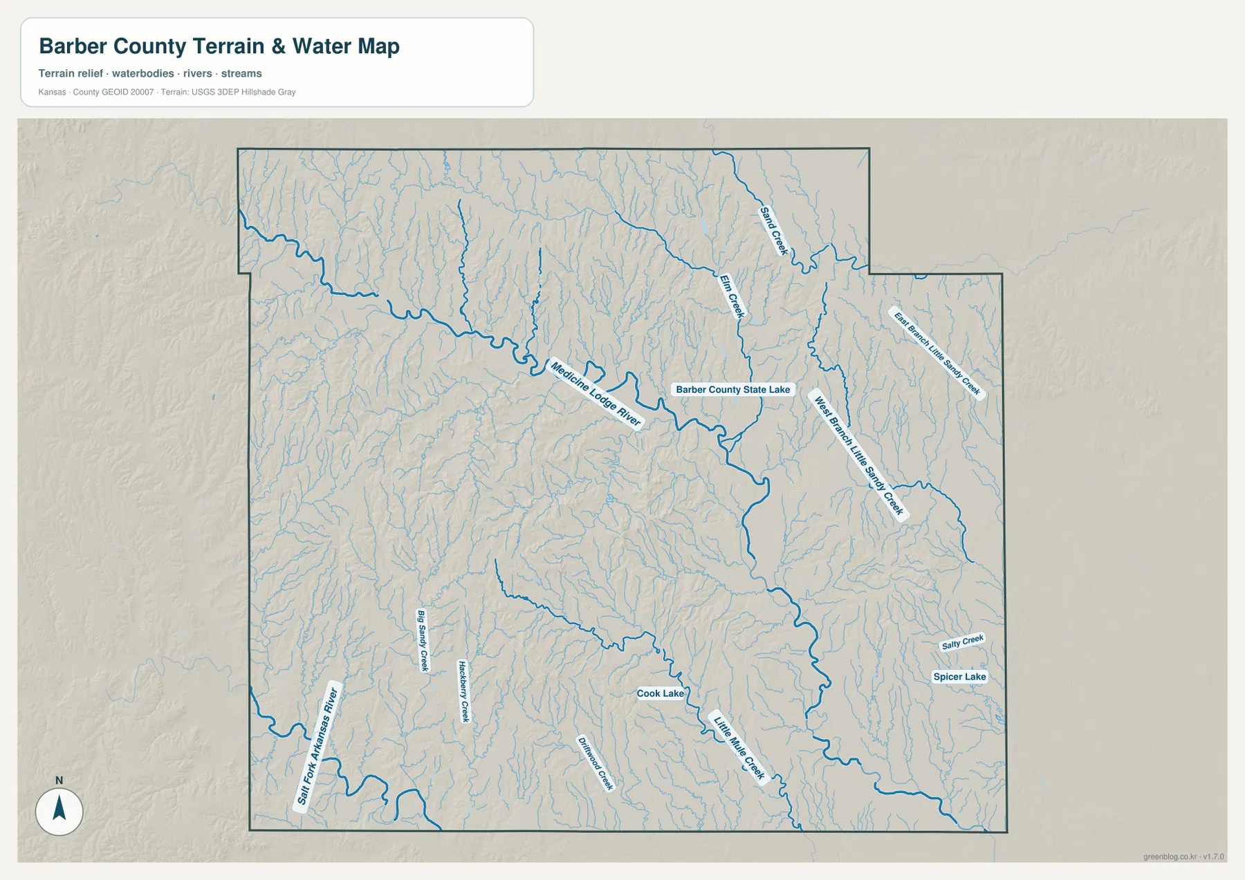
Three named lakes provide additional landmarks. Barber County State Lake lies in the central-eastern part of the map near the Medicine Lodge River and Elm Creek system, Cook Lake is farther south, and Spicer Lake appears in the southeast. None dominates the county at this scale, but each makes it easier to connect a water feature with nearby stream valleys. Barber County State Lake is especially useful as a reference because it sits close to the county’s main central drainage features.
This is a general geographic water map, not a live flood product, legal drainage map, parcel map, or navigation chart. River stages, flood warnings, access restrictions, and road closures can change quickly and should be checked through current official sources. Its value here is regional: the map shows where major named streams and smaller tributaries occupy the county and why the western and northern uplands appear so strongly dissected when compared with the broader lower terrain to the southeast.
Relief from 379 to 627 Meters: High West, Lower Southeast
The supplied elevation map reports an actual range of about 379 to 627 meters, with a mean near 500 meters. That span of almost 250 meters is large enough to produce a strong visual contrast. Brown and tan high ground covers much of the west and northwest, while green lower terrain follows the Medicine Lodge River corridor and spreads more widely across the central, eastern, and southeastern parts of the county. The relief map therefore changes the first impression created by the road map: Barber County is not simply an open grid of rural roads.
The western highlands are not one flat plateau. Numerous tributary valleys cut into the higher surface, producing repeated ridges and narrow lower corridors. The northern side also contains broad high areas, but Sand Creek, Elm Creek, and smaller channels create long low lines through them. Farther southeast, lower colors become more common overall, yet the surface remains dissected by small creeks, so the area should not be interpreted as a perfectly flat plain.
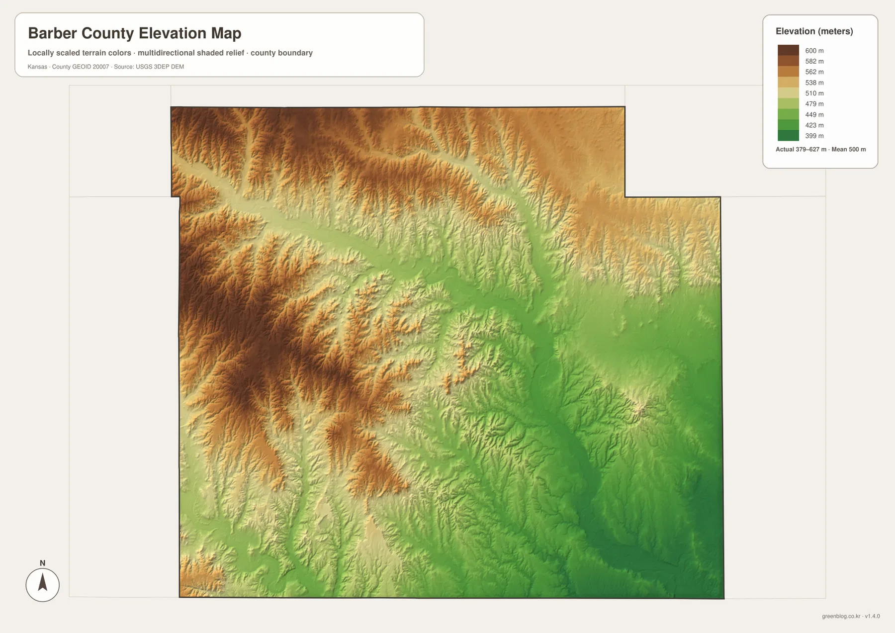
The Medicine Lodge River provides the clearest example of how the water and elevation maps reinforce one another. A major blue river corridor on the hydrography view becomes a long green valley on the elevation surface, while many tributaries cut narrow fingers into adjacent higher ground. This relationship helps explain why the road and settlement pattern cannot be understood from road lines alone: physical terrain influences the shape of valleys and the routes that must cross them, even when a highway does not follow a stream exactly.
The elevation surface is designed for county-scale comparison, not engineering or survey work. It should not be used to determine the exact elevation of a house, property corner, road grade, drainage project, or construction site. For general study, however, it is very effective. A reader can see immediately that western Barber County stands higher and is more rugged, while the central river corridor and much of the southeast occupy lower ground.
How Roads, Valleys, and Communities Fit Together
Because Barber County is large and lightly settled, the general road map is the natural starting point for travel orientation, but the terrain maps change how those distances are understood. A trip west from Medicine Lodge toward Sun City and Lake City reaches higher and more dissected country, while the U.S. 160 corridor toward Sharon stays closer to the central river-and-creek system. Southbound travel toward Hardtner follows the U.S. 281 axis through a different set of valleys, and the Kiowa–Hazelton side of the county occupies lower terrain near the southeastern edge.
Medicine Lodge and Kiowa are useful reference points because the space between them crosses both road corridors and creek-cut terrain. The general map shows the U.S. 160 and U.S. 281 framework and the local connections around each community, while the water and elevation views reveal valleys and relief that road lines alone do not show. Taken together, the maps explain why the county center and the southeastern communities occupy noticeably different settings even though they are linked by the same regional road network.
The Sun City and Lake City side provides the opposite kind of example. Road lines on the general map can make the area look sparse, but the elevation view reveals a complex pattern of high ridges and tributary valleys. This is useful for classroom geography or a regional comparison because it gives a concrete reason why western Barber County looks different from the Kiowa and Hazelton side. Instead of describing every community with the same generic rural-landscape language, the relief and drainage maps provide county-specific geographic detail.
Choosing the Right Barber County View
For basic orientation, begin with the general map that keeps Medicine Lodge, U.S. 160, U.S. 281, Kiowa, Hardtner, Sharon, Hazelton, Isabel, and Sun City in the same frame. Use the ranked city view when the main question is settlement spacing or relative prominence. The water-and-terrain map is best when stream names, lakes, and valley patterns matter, while the elevation map gives the clearest countywide comparison between the high west and the lower central and southeastern terrain.
The original JPG files in the ZIP are more convenient when labels need to be enlarged or printed. Each file measures 3638 × 2572 pixels and corresponds to one of the four maps shown in the article. The web previews are designed for quick reading on the page, while the originals make small road shields, creek names, and terrain details easier to inspect. For a class handout, personal map collection, travel notebook, or local reference, keeping the four images together also makes direct comparison simpler.
These maps are intended for general geographic explanation and reference. They do not replace legal boundary records, parcel ownership information, live road conditions, flood certification, engineering plans, or professional surveying. When a decision requires official precision, current information from Barber County, the U.S. Census Bureau, USGS, or another responsible agency should be used alongside this map set.
Frequently Asked Questions
Which map is best for comparing Medicine Lodge and Kiowa?
Start with the ranked city map when you want a clean view of their relative size and separation, then add the general county map for roads. Medicine Lodge lies around the U.S. 160 and U.S. 281 junction area in the north-central to northeastern interior, while Kiowa is close to the southeastern boundary, so the road map is important for understanding how the two centers connect.
Where is the highest terrain in Barber County?
The supplied elevation surface shows the broadest high terrain across the west and northwest. The mapped range is about 379 to 627 meters, with a mean near 500 meters. Lower green corridors follow the Medicine Lodge River and other major drainages, and generally lower terrain becomes more extensive toward the central, eastern, and southeastern parts of the county.
Can the Medicine Lodge River and Elm Creek map be used for flood or property decisions?
No. The terrain-and-water map is a general geographic reference for the Medicine Lodge River, Elm Creek, Sand Creek, Little Sandy Creek branches, named lakes, and other drainage features. Current flood risk, legal parcel boundaries, drainage rights, public access, and real-time water levels should be verified through USGS, Barber County, and other responsible authorities.
Map File Information
The ZIP contains the high-resolution JPG originals corresponding to the Barber County general, city, terrain-and-water, and elevation maps shown on this page.
- File Type: ZIP containing 4 JPG files
Related Maps
Sources and References
For local government and county background, see the official Barber County website and the Kansas Historical Society Barber County page. Boundary and base geography can be checked through the U.S. Census Bureau TIGER/Line files, water features through USGS National Hydrography, and terrain through the USGS 3D Elevation Program.
Green Map creates custom-edited map images using open geographic data sources such as geoBoundaries, Natural Earth, OpenStreetMap, and government open data.
These maps are edited visual materials, not raw data files, and are provided for education, documents, presentations, and graphic reference.