You can download four high-resolution A3 JPG maps of Milam County, Texas, in one ZIP directly from this page. The package includes a general county map, a Rockdale-centered city-connections map, a terrain-and-water map, and an elevation map. Together they show Cameron, Rockdale, Milano, Thorndale, Buckholts, Gause, roads 36, 79, 77, and 190, Little River and San Gabriel River, named creeks and lakes, and an actual elevation range of about 66 to 197 meters.
Milam County is easier to understand when Cameron and Rockdale are used as two separate reference points rather than forcing everything around a single center. Cameron lies in the north-central interior, while Rockdale is farther southwest. The road map connects them through a network that also reaches Buckholts, Milano, Thorndale, and Gause. Beneath that road pattern, the water and elevation layers show a second geography: river valleys occupy lower central and eastern terrain, while the south and southwest contain higher, more strongly dissected hills.
Table of Contents
Cameron and Rockdale organize two different parts of the county
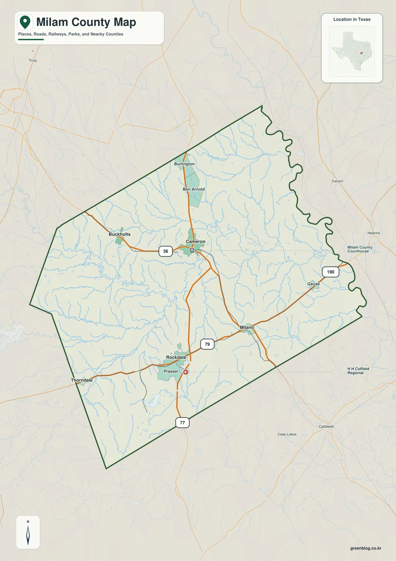
Cameron is the strongest north-central place label on the general map. Route 36 approaches from the Buckholts side, while Burlington and Ben Arnold lie farther north. South of Cameron, the road network bends toward the Rockdale and Milano area. This creates a clear separation between the central-northern settlement pattern and the more developed southwestern group.
Rockdale is prominent in the southwest, with Praesel nearby and Thorndale farther west close to the boundary. Milano sits east of Rockdale along the Route 79 corridor. Gause is farther east, near Route 190 and the irregular eastern edge of the county. These communities make the map feel less like a simple Cameron-centered county and more like several local clusters connected by long rural roads.
Route 77 is labeled south of Rockdale and gives a useful north-south reference along the lower part of the map. The eastern boundary is much more winding than the western and southern sides, following an irregular line close to numerous stream channels. That edge helps distinguish the lower river country from the straighter road-and-boundary pattern around Thorndale and the southwest.
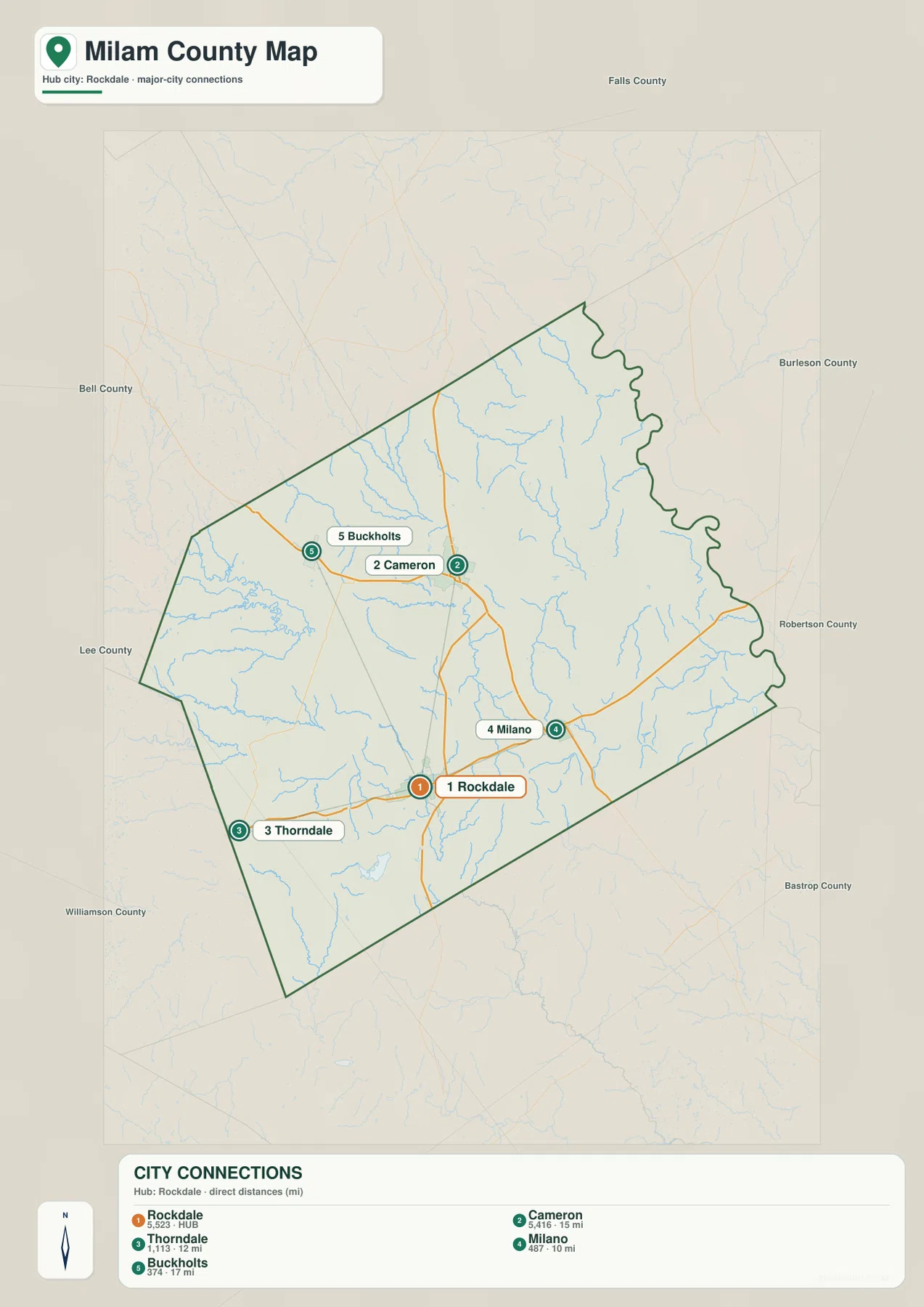
The city-connections map uses Rockdale as the distance hub
The simplified city map connects Rockdale directly to four other communities. The labels show about 10 miles to Milano, 12 miles to Thorndale, 15 miles to Cameron, and 17 miles to Buckholts. These are straight-line distances between mapped points, not driving distances or estimated travel times.
The direction of each line is just as useful as the number. Cameron lies north of Rockdale, Milano to the east, Thorndale to the west-southwest, and Buckholts to the northwest. Removing most road detail makes the relative arrangement easy to understand before returning to the general map for the actual road corridors.
The lower index also prints Rockdale 5,523, Cameron 5,416, Thorndale 1,113, Milano 487, and Buckholts 374. The supplied image does not identify a year for these values, so this article treats them only as numbers shown on the map rather than confirmed current population counts. The primary value of this layer is the direct-distance and direction comparison.
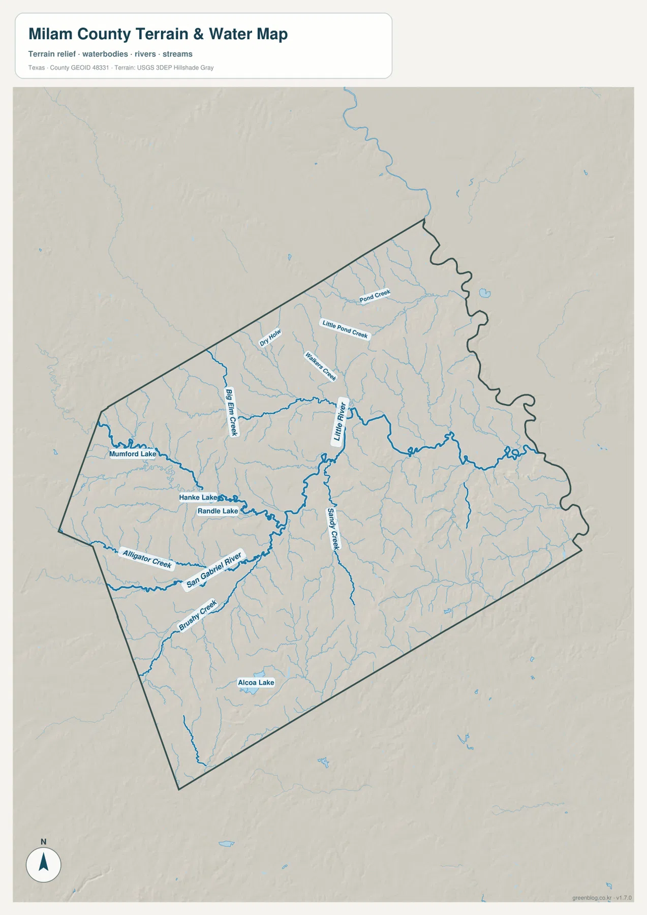
Little River ties together the central drainage while northern creeks feed the valley
Little River is one of the strongest named water references in the central terrain-and-water map. It occupies a broad lower corridor that receives tributaries from the north and west before continuing toward the eastern side. Sandy Creek joins the same central lowland from the south. When compared with the Cameron-to-Milano area on the general map, the river system explains why the middle of the county appears lower and greener on the elevation layer.
Big Elm Creek is a prominent northwestern tributary. Dry Hollow and Walkers Creek are labeled nearby, while Pond Creek and Little Pond Creek appear farther north and northeast. The density of these tributaries gives the upper half of Milam County a more complicated drainage pattern than the road map suggests.
San Gabriel River and western lakes mark the lower-left side of the county
San Gabriel River is the strongest named river in the southwestern portion of the water map. It enters from the west and follows a broad lower corridor toward the central-southern interior. Brushy Creek and Alligator Creek occupy nearby valleys, adding separate tributary references around the Rockdale and Thorndale side.
Munford Lake lies in the west, with Hanke Lake and Randle Lake close together farther southeast. Alcoa Lake is labeled in the southern interior. These lakes are smaller than the main river systems, but they provide useful landmarks for matching the water layer to the western and southern parts of the county.
The terrain-and-water map is intended for geographic reference. It can help locate Little River, San Gabriel River, named creeks, and lakes relative to the county boundary, but it is not a flood-hazard map, parcel map, legal water-boundary product, or navigation chart. For road access and settlement locations, compare the same area with the general county map.
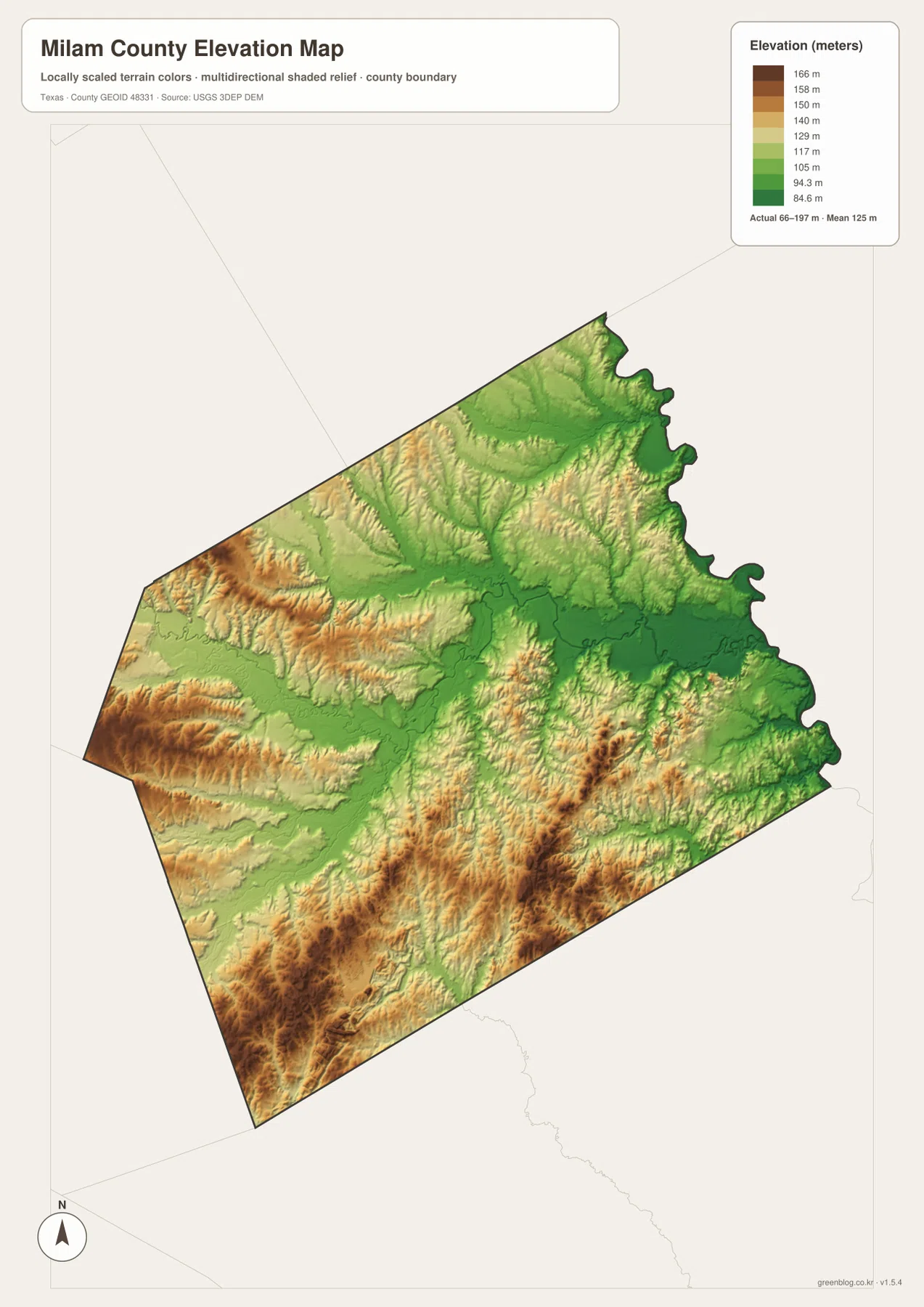
Higher southern hills fall into broad central and eastern river valleys
The elevation map reports an actual range of about 66 to 197 meters and a mean elevation of about 125 meters. Darker browns are concentrated across the south and southwest, with additional higher ridges toward the west. The central and eastern portions are much greener, especially along the Little River and major creek corridors.
The southwestern high ground is deeply cut by drainage. San Gabriel River, Brushy Creek, and smaller channels follow lower green paths between tan and brown hills. This explains why the Rockdale-Thorndale side looks more strongly textured than the broad lower country farther east of Cameron.
Some elevated ridges also appear in the north, but the widest continuous low terrain follows the central river network and extends toward the eastern boundary. The difference between the displayed minimum and maximum elevation is about 131 meters. That is not mountain-scale relief, yet it produces a clear hill-and-valley contrast across the county.
The elevation layer is best used for relative terrain comparison rather than survey-grade or engineering-grade measurement. Its value here is to connect Cameron and Rockdale with the Little River and San Gabriel River systems and show why the county’s southern half differs so strongly from the central lowlands.
The Rockdale-to-Cameron comparison brings roads, rivers, and relief together
Start at Rockdale on the general map and look north toward Cameron. The road layer shows the relationship among Route 79, Route 36, and the communities between the two areas. On the water map, the San Gabriel River and Little River systems occupy lower corridors across the same broad interior. The elevation layer adds the final contrast, with higher southwestern hills giving way to lower central terrain.
The Rockdale hub map is useful when direct distance and direction are the main questions, while the general map provides the actual road numbers and additional places such as Burlington, Ben Arnold, and Gause. River, creek, and lake labels are clearest on the terrain-and-water map, and the elevation layer is the fastest way to compare southern hills with central lowlands. Small labels are often easier to inspect in the downloadable high-resolution JPG files than in the browser previews.
Frequently Asked Questions
What straight-line distances are shown from Rockdale?
The city-connections map shows about 10 miles from Rockdale to Milano, 12 miles to Thorndale, 15 miles to Cameron, and 17 miles to Buckholts. These are direct map distances, not driving distances.
Which rivers are the clearest water references?
Little River is the strongest central reference, while San Gabriel River is prominent in the southwest. Big Elm Creek, Sandy Creek, Brushy Creek, and Alligator Creek are also labeled, along with Munford Lake, Hanke Lake, Randle Lake, and Alcoa Lake.
What elevation range is shown for Milam County?
The supplied elevation map reports an actual range of about 66 to 197 meters and a mean elevation of about 125 meters. The south and southwest are generally higher, while the Little River and other central and eastern drainage valleys occupy lower terrain.
Sources and Reference Data
- U.S. Census Bureau TIGER/Line Shapefiles — official county-boundary and road geometry for geographic reference.
- USGS National Hydrography — official resources for rivers, creeks, lakes, and other water features.
- USGS 3D Elevation Program — official elevation resources used for terrain information.
- USGS The National Map Viewer — an official viewer for comparing geographic layers.
Map File Information
Download four high-resolution A3 JPG maps of Milam County, Texas, in one ZIP file.
- Included Files: county map, city-connections map, terrain and water map, elevation map
- File Type: JPG
Related Maps
- Robertson County Texas map
- Williamson County Texas map
- Washington County Texas map
- Bastrop County Texas map
- San Saba County Texas map
Green Map creates custom-edited map images using open geographic data sources such as geoBoundaries, Natural Earth, OpenStreetMap, and government open data.
These maps are edited visual materials, not raw data files, and are provided for education, documents, presentations, and graphic reference.