Russell County sits in north-central Kansas where Interstate 70, the Smoky Hills, and two major river systems meet. Russell is the dominant city and county seat, while Gorham, Bunker Hill, Dorrance, Lucas, and Luray are spread across a much more rural landscape. Wilson Lake occupies the eastern side, the Saline River crosses the north, and the Smoky Hill River creates a separate southern lowland.
This guide uses the supplied maps to connect those places with I-70, US 40, US 281, local creeks, and an elevation range of roughly 438 to 629 meters. The WebP images are convenient for on-page viewing, while the matching high-resolution JPG files are available together in the download ZIP for printing, classroom use, and offline reference.
Table of Contents
I-70 makes Russell the easiest starting point for the county
Russell sits just south of the county center on Interstate 70 and US 40. US 281 turns north from the city into the rural interior, while the I-70 corridor links Gorham on the west with Bunker Hill and Dorrance on the east. Highways, rail lines, and local streets are concentrated around Russell more strongly than anywhere else in the county.
Russell County and the Kansas Historical Society identify Russell as the county seat. That role followed a nineteenth-century contest with Bunker Hill, and Russell became the permanent seat in 1874. The present transportation pattern makes the city a natural reference point for nearly every other feature on the map.
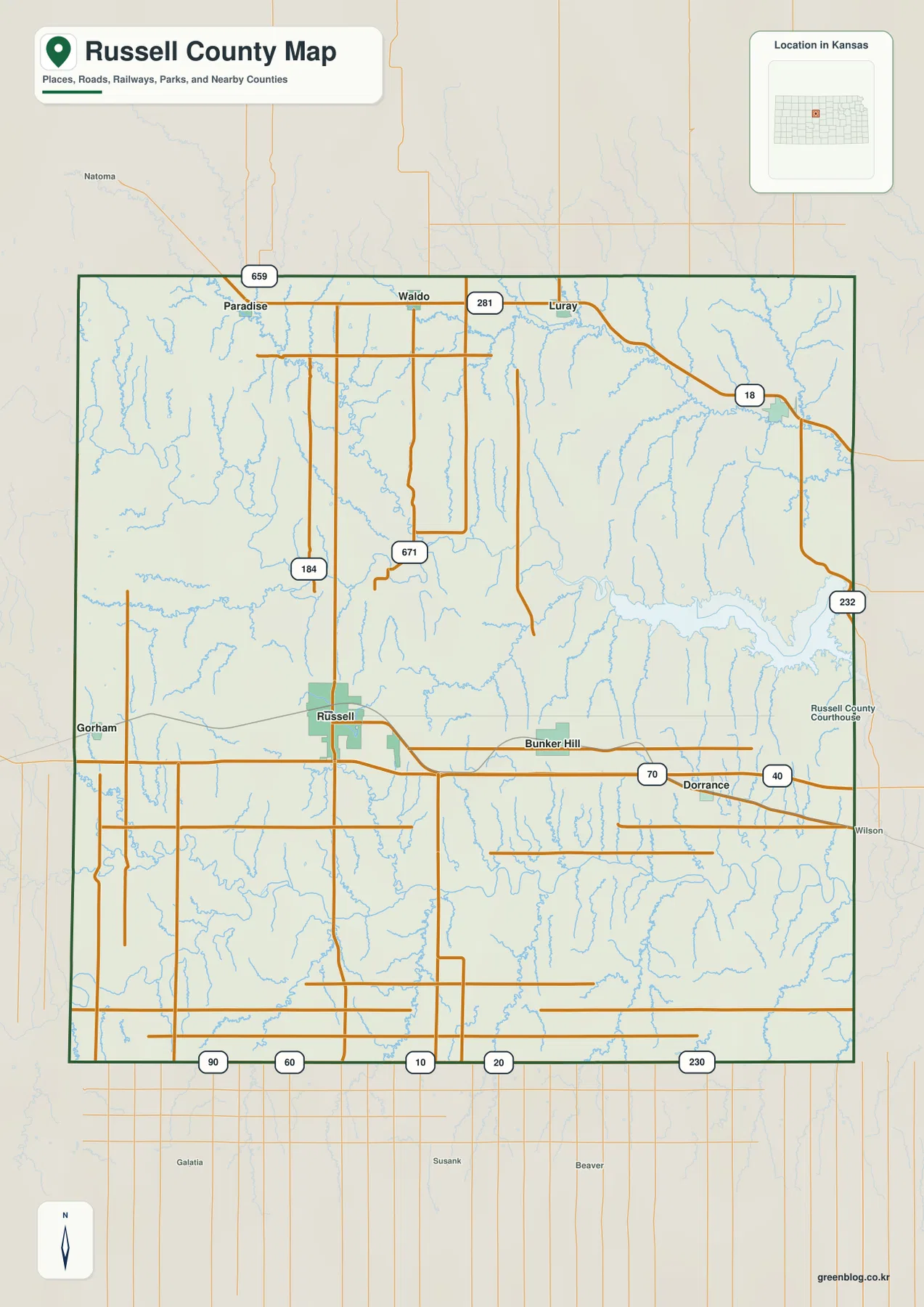
The northeastern road pattern is much less concentrated. K-18 serves the Luray side, and K-232 is an important approach to Wilson Lake. Lucas sits away from the main interstate corridor in hillier country cut by creeks.
Russell is far larger on the city index, but Lucas and Gorham show two different sides of the county
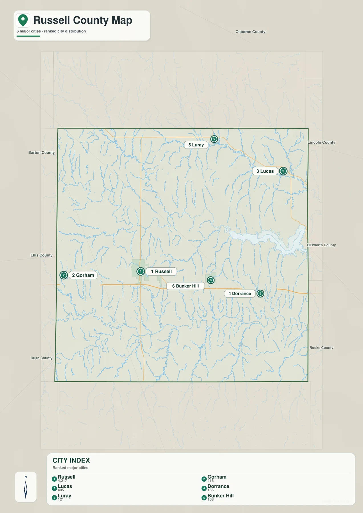
The city map lists Russell at 4,217, Gorham at 416, Lucas at 405, Dorrance at 156, Luray at 121, and Bunker Hill at 108. These are map index values rather than current official population estimates, so they should be used only to compare the relative prominence of the mapped communities.
Gorham belongs to the western I-70 and US 40 corridor, while Lucas occupies the northeastern hills near the Wilson Lake country. Bunker Hill and Dorrance lie east of Russell along the interstate route but remain much smaller on the city index.
Kansas Historical Society population material also identifies Russell as the county’s largest city. The census figures and the supplied city index are different datasets, but they point to the same broad settlement pattern: one strong county center and several small rural communities.
The Saline River and Smoky Hill River divide the county into two major drainage settings
Northern Russell County is organized around the Saline River. The river enters from the west, bends through the north-central part of the county, and continues into the Wilson Lake system. Paradise Creek, Wolf Creek, East Fork Wolf Creek, and smaller tributaries cut down from the surrounding hills.
Wilson Lake is the largest water body on the supplied map. Cedar Creek and numerous short tributaries enter the reservoir, and the shoreline lies immediately below closely spaced ridges. K-232 provides a useful road reference when matching the general map to the lake area.
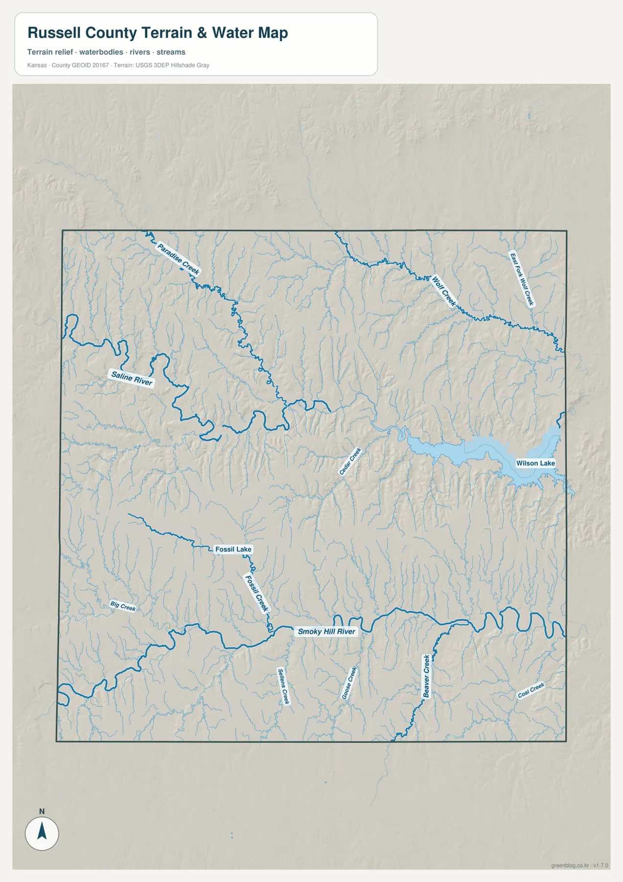
The Smoky Hill River forms a separate broad low corridor across the southern part of the county. Fossil Creek descends from the Fossil Lake area, while Big Creek, Goose Creek, Beaver Creek, and Coal Creek drain the surrounding uplands. The high ground between the Saline and Smoky Hill systems is cut by many smaller valleys rather than forming one smooth plateau.
This water image is for geographic reference rather than floodplain, navigation, water-quality, parcel, or legal-access decisions. Reservoir levels and stream conditions change, so current agency information should be checked before boating or other water-based activities.
Western hills stand higher than the Wilson Lake and river corridors
The elevation surface ranges from about 438 to 629 meters, with an average near 533 meters. Higher brown and tan terrain is concentrated in the west and southwest. Lower green terrain follows the Saline River, Wilson Lake, and the Smoky Hill River.
The contrast becomes especially clear along I-70. West of Russell toward Gorham, higher ground occupies more of the landscape and large connected water features disappear. East through Bunker Hill and Dorrance, tributaries become denser and the route approaches the lower Wilson Lake and Saline River country.
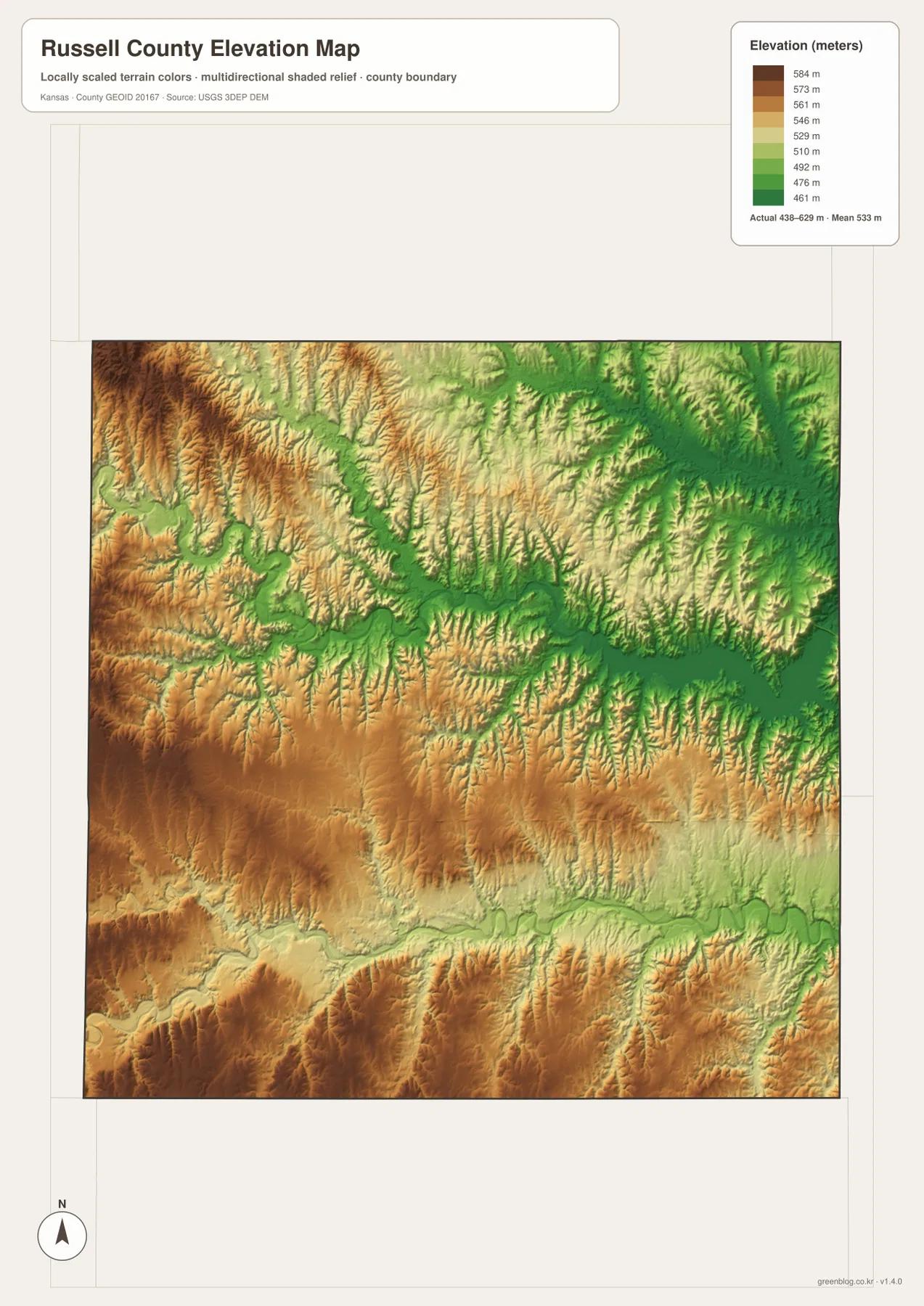
The Smoky Hill River creates another long low band in the south, with Fossil Creek and other tributaries descending from the surrounding hills. Russell itself sits on intermediate terrain rather than at either extreme, which makes it a useful midpoint for comparing the county’s higher west and lower river corridors.
This is a generalized county-scale elevation image. It is not survey-grade or engineering-grade information and should not be used for parcel elevations, construction grading, drainage design, or legal boundary work.
Wilson State Park puts the eastern Smoky Hills terrain into a real-world setting
Kansas Department of Wildlife and Parks places Wilson State Park in the heart of the Smoky Hills, a short drive north of I-70. The reservoir shoreline is known for rocky outcrops, steep hills, and irregular coves, matching the highly dissected terrain visible around the lake on the relief map.
Camping, fishing, boating, trails, and wildlife viewing make the park one of the county’s strongest outdoor landmarks. Conditions at the reservoir can change with water level and season, so current park information remains the best source for access and facility details.
Lucas is small on the map but memorable because of the Garden of Eden
Lucas has a city index of 405, yet it contains one of the county’s best-known cultural landmarks. The Kansas Historical Society records that Samuel Dinsmoor began building the Garden of Eden after 1905 and created more than 200 concrete sculptures around his limestone home.
The town sits in the northeastern hills between the Saline River country and Wilson Lake. K-18 and local roads provide the main access, and the Garden of Eden gives the Lucas area a distinctive identity that is easy to connect with the map.
An east–west trip through Russell shows how quickly the terrain changes
Driving the I-70 corridor west from Russell toward Gorham keeps the route in higher, more open country. Traveling east toward Bunker Hill and Dorrance brings more creek valleys into view and moves the route closer to Wilson Lake and the Saline River system.
A north–south comparison is equally useful: US 281 leaves Russell for the rural north, while the Smoky Hill River creates a separate lowland to the south. Reading the road, water, and elevation images together makes the county easier to understand than treating each map as an isolated layer.
For posters, classroom prints, and presentation materials, the original JPG files in the archive are preferable to enlarging the web previews. Small road labels, creek names, town text, and the elevation legend remain clearer at the higher resolution.
Frequently Asked Questions
What is the easiest route reference between Russell and Wilson Lake?
I-70 is the clearest starting point at Russell. Traveling east through the Bunker Hill and Dorrance side and then using K-232 provides a straightforward way to relate the highway map to the Wilson Lake area.
Are the Saline River and Smoky Hill River the same river?
No. The Saline River crosses the northern part of the county and feeds the Wilson Lake system, while the Smoky Hill River forms a separate major valley across the south. Higher Smoky Hills terrain lies between the two drainage systems.
Can the 438–629 meter elevation image be used for surveying?
No. It is a generalized county-scale terrain image for comparing higher hills with lower river and reservoir valleys. Parcel elevations, engineering grades, drainage design, and legal boundary work require more precise official data and, when appropriate, professional surveying.
Map File Information
The archive contains the Russell County, Kansas general county map, city map, terrain-and-water map, and elevation map as original high-resolution JPG files.
- Included Files: Use only the versions confirmed in the article and supplied images
- File Type: Use the confirmed download contents
- Intended Use: Printing, education, presentations, and map-based projects
Related Maps
Sources and references
- Russell County, Kansas: History of Russell County — county seat and local history
- Kansas Historical Society: Russell County, Kansas — Smoky Hills, communities, and county history
- Kansas Department of Wildlife and Parks: Wilson State Park — Wilson Reservoir and park information
- Kansas Historical Society: Samuel Dinsmoor — Lucas Garden of Eden and sculpture history
- U.S. Census Bureau TIGER/Line Shapefiles — county boundary and geographic reference data
- USGS 3D Elevation Program — elevation and terrain reference data
Green Map creates custom-edited map images using open geographic data sources such as geoBoundaries, Natural Earth, OpenStreetMap, and government open data. These maps are edited visual materials, not raw data files, and are provided for education, documents, presentations, and graphic reference.