Perry County in central Arkansas is organized around one long river valley. The Fourche La Fave River crosses the county from west to east, while parallel Ouachita Mountain ridges rise on both sides of the low corridor around Perryville. Download the four high-resolution JPG maps on this page together in one ZIP file. The package includes the general county map, ranked city map, terrain and water map, and elevation map. Casa and Aplin lie to the west, Adona and Perry occupy the central-northern area, and Houston and Bigelow are farther east. The elevation map spans about 76 to 547 meters with a mean near 180 meters, so the contrast between river bottom and mountain ridge is substantial.
Perryville is the county seat and the best point from which to understand the landscape. The Encyclopedia of Arkansas places Perry County in the Ouachita Mountains, with the Arkansas River Valley along the eastern side and the Fourche La Fave River running across the county. Its Perryville entry describes the town in the Fourche River valley between mountains to the north and south. Those descriptions match the supplied maps closely: a broad green valley runs across the middle, and long tan and brown ridges rise above it in nearly parallel bands.
Table of Contents
Perryville sits where the valley roads gather before spreading east and west
The general map places Perryville slightly east of the county center, where several roads converge. Route 10 approaches from the Casa and Adona side, while Routes 60 and 77 continue toward the northeastern edge near the Arkansas River country. Houston lies east of Perryville, and Route 216 provides a useful reference toward Bigelow. Route 300 loops through the area south of Perryville, while Route 9 continues into the southern mountain section. Using the Fourche La Fave valley as the main reference makes these routes much easier to organize.
The western side is more broken by ridges and streams. Casa sits near Routes 155 and 247, with Route 324 extending toward the Adona side. Aplin lies farther south in the west-central valley. Route 314 and Route 7 cross the southwestern section, where roads bend around much rougher terrain. The road map becomes especially useful when compared with elevation shading because the turns often follow low gaps between ridges instead of straight survey lines.
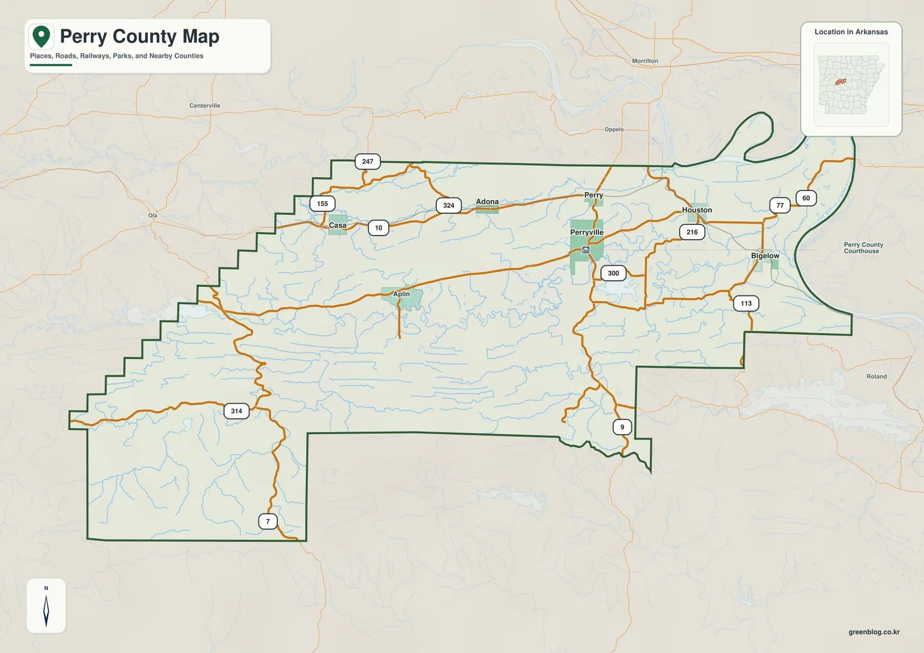
The Perryville-Houston-Bigelow side opens into somewhat lower terrain than the southwest. Route 113 appears south and east of Bigelow, and the roads around Perryville connect into the lower eastern side of the county. The northeastern boundary becomes noticeably irregular near the broad Arkansas River corridor, while much of the southwest is enclosed by straighter county lines. This transition helps explain why Perry County can feel both mountainous and connected to a major river valley at the same time.
Six ranked communities follow the main valley and nearby road corridors
The city map ranks six major communities. Perryville is number 1, Bigelow 2, Perry 3, Houston 4, Casa 5, and Adona 6. These numbers are ranking markers rather than distance measurements. Perryville and Perry sit close together in the central-eastern section, Houston and Bigelow continue farther east, and Casa and Adona are separated toward the west and north-central interior. The distribution is elongated rather than clustered in one dense urban area, reflecting the valley-and-ridge geography of the county.
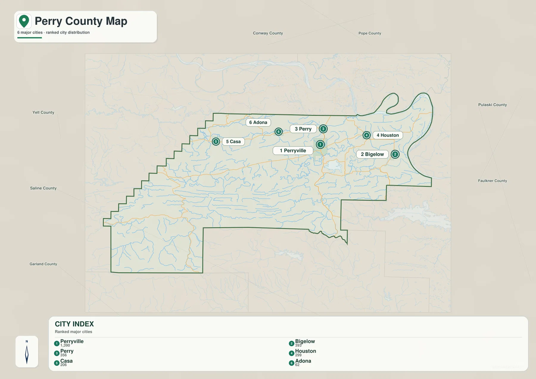
Perryville is both the top-ranked community on the supplied map and the county seat. Its setting becomes clearer when the city and elevation maps are compared. The town occupies the broad low corridor of the Fourche La Fave River, with mountain ridges immediately to the north and south. Casa and the southwestern road network are closer to higher terrain, while the Bigelow side approaches the lower Arkansas River Valley. Settlement therefore follows the easiest parts of a landscape that is otherwise strongly divided by long ridges.
The city legend also includes numeric values beside the community names, but this article does not reinterpret those figures as current population estimates. The supplied map clearly supports the ranking and geographic position of the six communities, so those are the facts used here. Current population totals should be checked against recent Census data. For close names such as Perry and Perryville, the general road map is especially helpful because it shows the two locations in relation to Route 10 and the river valley.
Fourche La Fave River forms the county’s main low corridor
The Fourche La Fave River is the dominant water feature on the terrain and water map. It enters from the west, winds through the middle of Perry County, and continues east toward the Arkansas River. The Encyclopedia of Arkansas likewise describes the river as crossing the county from west to east. Aplin, Perryville, and Houston all sit near this broad central corridor, so the water map helps explain why roads and communities line up in roughly the same direction.
The southwestern terrain contains a separate branch of the drainage system. South Fourche La Fave River and Dry Fork Fourche La Fave River occupy deep valleys below the main river. Bear Creek and Cedar Creek also cut through the southern ridges. North of the main valley, Big Creek, Rock Creek, and Rocky Cypress Creek descend from long parallel highlands. These tributaries make the water map look much denser than the road map and show how thoroughly the mountains are divided by narrow stream corridors.
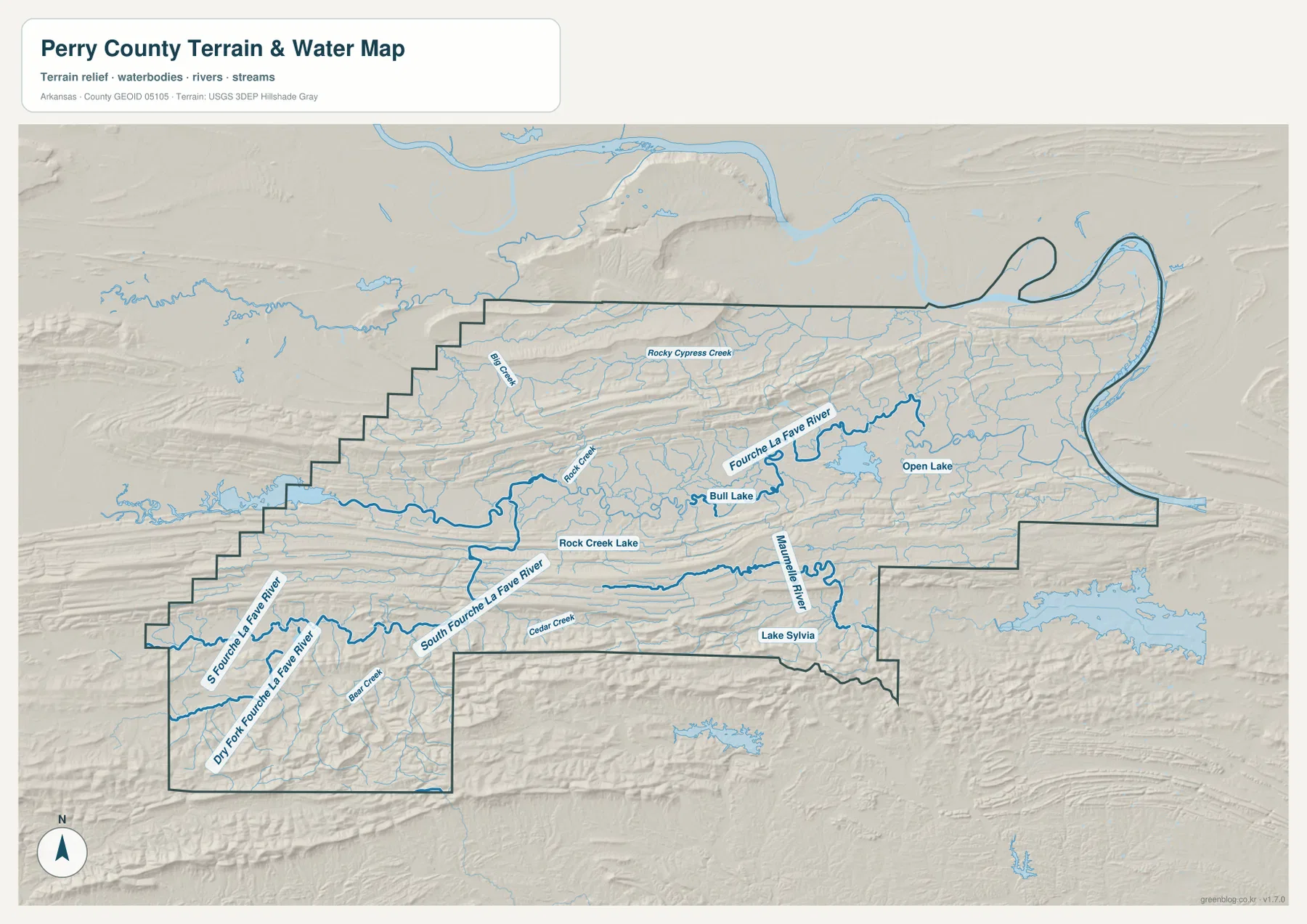
Bull Lake and Rock Creek Lake are labeled near the central interior, while Open Lake appears farther east. In the southeast, the Maumelle River follows another low valley, with Lake Sylvia shown nearby. This southeastern drainage runs in a different corridor from the Fourche La Fave, creating another clear break through the ridges. The county therefore has one major central river valley plus several smaller systems that drain different mountain blocks.
The Fourche La Fave has a long history of flooding and has influenced settlement and transportation in the valley. The supplied map, however, is intended for general geographic reference. It does not show current river stage, flood risk, boating conditions, fishing rules, property boundaries, or live road access. Current USGS and managing-agency information should be used for river, flood, or outdoor-safety decisions.
Elevation jumps from 76 to 547 meters across parallel Ouachita ridges
The elevation map shows an actual countywide range of about 76 to 547 meters, with a mean near 180 meters. That is roughly 471 meters of relief. The Fourche La Fave valley appears as a long green lowland across the middle, while several tan and brown ridges run east-west above and below it. The pattern is one of the clearest examples on the Arkansas county maps of a river corridor separating parallel mountain belts.
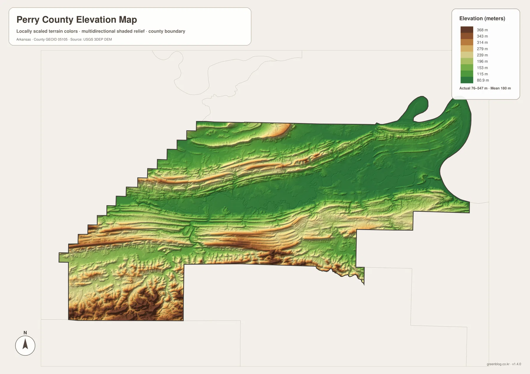
The southwest contains some of the most rugged terrain. Routes 7 and 314 cross an area of dark brown ridges, while the South Fourche La Fave River and Dry Fork occupy deep green valleys between them. Instead of one rounded mountain mass, the high ground is divided into long narrow ridges with streams cutting through the gaps. That structure explains why road distance can be much longer than a simple straight-line comparison would suggest.
East of Perryville toward Bigelow, the terrain generally drops toward the Arkansas River Valley, although shorter ridges still interrupt the low ground. The southeastern Maumelle River and Lake Sylvia area creates another green corridor through the mountains. The elevation map is therefore best used to follow the repeated relationship between ridge and river valley rather than to identify a single summit. Exact road, parcel, or building elevations require original USGS data or survey-grade measurement.
Trace the valley from Casa to Bigelow, then compare the southern mountains
A practical way to use all four maps is to follow the county from west to east. Start around Casa, move through Adona and Perryville, continue past Houston, and finish near Bigelow. The road map places these communities along the same broad corridor, the water map follows the Fourche La Fave River through it, and the elevation layer keeps the route within the county’s lowest central terrain. The three views reinforce one another without requiring every road or tributary name to be memorized.
Then look south from the central valley. The southwest contains much higher ridges and the South Fourche La Fave system, while the southeast contains the Maumelle River and Lake Sylvia corridor. Comparing those two southern areas with the Perryville valley shows why Perry County is more than a generic mountain county. Its settlements occupy broad river-bottom openings between long parallel ridges, and the eastern side gradually connects those mountain valleys with the Arkansas River Valley.
The WebP images in the article are optimized for quick page viewing, while the download ZIP contains the same four maps as high-resolution JPG files. Each JPG measures 3638 × 2572 pixels in landscape orientation. Use the general map for Perryville, Bigelow, Casa, roads, and boundaries; the ranked city map for the six major communities; the terrain and water map for the Fourche La Fave, South Fourche La Fave, Maumelle River, creeks, and lakes; and the elevation map for comparing the county’s 76–547 meter ridge-and-valley relief.
Frequently Asked Questions
What is the county seat of Perry County?
Perryville is the county seat. It lies in the Fourche La Fave River valley and is the strongest central road reference on the supplied map. Starting at Perryville makes it easier to locate Casa and Adona to the west and Houston and Bigelow to the east.
Why is the Fourche La Fave River important on the Perry County map?
The river crosses Perry County from west to east and creates the broad central lowland where several communities and roads are concentrated. Long Ouachita Mountain ridges rise on both sides, so the river valley is the clearest geographic feature tying the county together.
How much elevation change is shown across Perry County?
The supplied elevation map shows an actual range of about 76–547 meters with a mean near 180 meters. That is roughly 471 meters of relief, with the Fourche La Fave valley much lower than the northern and southern ridges, especially the rugged southwestern section.
Map File Information
The ZIP contains the general county map, ranked city map, terrain and water map, and elevation map as high-resolution JPG files for printing or offline reference.
- File Type: ZIP containing 4 JPG files
Related Maps
Sources and references
- Encyclopedia of Arkansas – Perry County – Ouachita Mountains, Arkansas River Valley, Fourche La Fave River, and county geography
- Encyclopedia of Arkansas – Perryville – Perryville county-seat and Fourche La Fave valley information
- Encyclopedia of Arkansas – Fourche La Fave River – the river through Perry County and the South Fourche La Fave branch
- U.S. Census Bureau TIGER/Line Shapefiles – county boundary and road data
- USGS National Hydrography – rivers, creeks, lakes, and hydrography data
- USGS 3D Elevation Program – elevation and terrain data
Green Map creates custom-edited map images using open geographic data sources such as geoBoundaries, Natural Earth, OpenStreetMap, and government open data.
These maps are edited visual materials, not raw data files, and are provided for education, documents, presentations, and graphic reference.