Ouachita County in south-central Arkansas is centered on Camden, where the Ouachita River makes a broad bend beside the county’s largest urban area. Download the four high-resolution JPG maps on this page together in one ZIP file. The package includes the general county map, ranked city map, terrain and water map, and elevation map. Chidester lies to the west, Bearden to the east, Stephens to the southwest, and Louann to the south, while the Little Missouri River crosses the northern edge. The supplied elevation map ranges from about 23 to 124 meters with a mean near 56 meters, showing a strong contrast between rolling western hills and the much lower Ouachita River plain.
Camden is the county seat and the best reference point for reading the maps. The Encyclopedia of Arkansas describes the city as standing on a bluff at a horseshoe curve of the Ouachita River, and the county itself takes its name from that river. On the supplied general map, Camden occupies the central-eastern area where Route 7 and several other roads meet. East Camden lies immediately to the east, while Chidester, Bearden, Stephens, and Louann spread into very different terrain settings around the county.
Table of Contents
Camden separates the road network toward Chidester, Bearden, and the southern towns
The general county map is busiest around Camden. Route 7 runs north-south through the central area, while Routes 9 and 205 extend toward East Camden and the eastern side. Route 76 reaches west toward Chidester. Near the western boundary, Routes 24, 368, and 387 provide useful references around Reader and Chidester. Starting at Camden and following one direction at a time makes the widely scattered communities much easier to place.
Bearden occupies the eastern side near Route 203, with Route 9 providing the stronger link back toward East Camden and Camden. The terrain is generally lower and smoother in this direction than west of the county seat, and several road segments remain relatively straight. Chidester and the western interior have more small streams and rolling ground, so the road pattern bends more often. The contrast is already visible on the road map and becomes much clearer on the elevation layer.
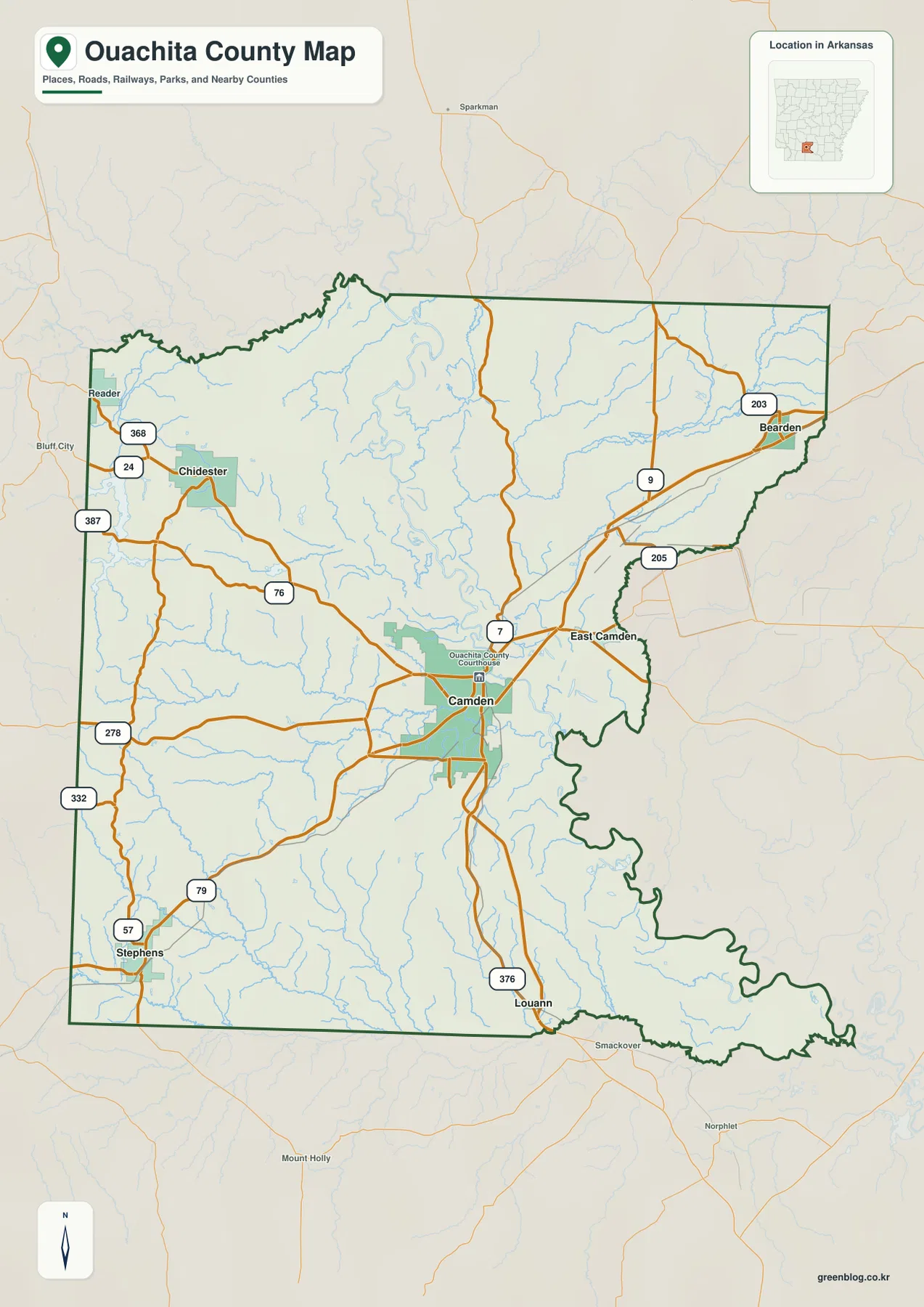
The southern road pattern spreads into a much larger rural area. Stephens is in the southwest near Routes 79 and 57, while Louann sits farther east near Route 376. Routes 278 and 332 follow the western side through the long north-south interior. As the map moves away from Camden, communities become smaller and farther apart, and roads pass through wooded creek country rather than one continuous developed corridor.
The county boundary is especially irregular along the east and southeast. Comparing the general and water maps shows the boundary close to the Ouachita River and Two Bayou lowlands, where long bends replace straight survey lines. The Little Missouri River also follows part of the northern edge. Clark, Dallas, Calhoun, Union, Columbia, and Nevada counties surround Ouachita County, placing it between the river lowlands and rolling Coastal Plain terrain of southern Arkansas.
The ranked city map shows a dominant Camden center with smaller communities spread outward
The city map ranks six major communities. Camden is number 1, Stephens 2, East Camden 3, Bearden 4, Chidester 5, and Louann 6. These numbers are ranking markers rather than distance measurements. Camden is the clear central-eastern hub, with East Camden immediately nearby. Bearden lies much farther east, Chidester to the west, and Stephens and Louann occupy separate parts of the south. The pattern is one large county center surrounded by smaller towns rather than a continuous urban strip.
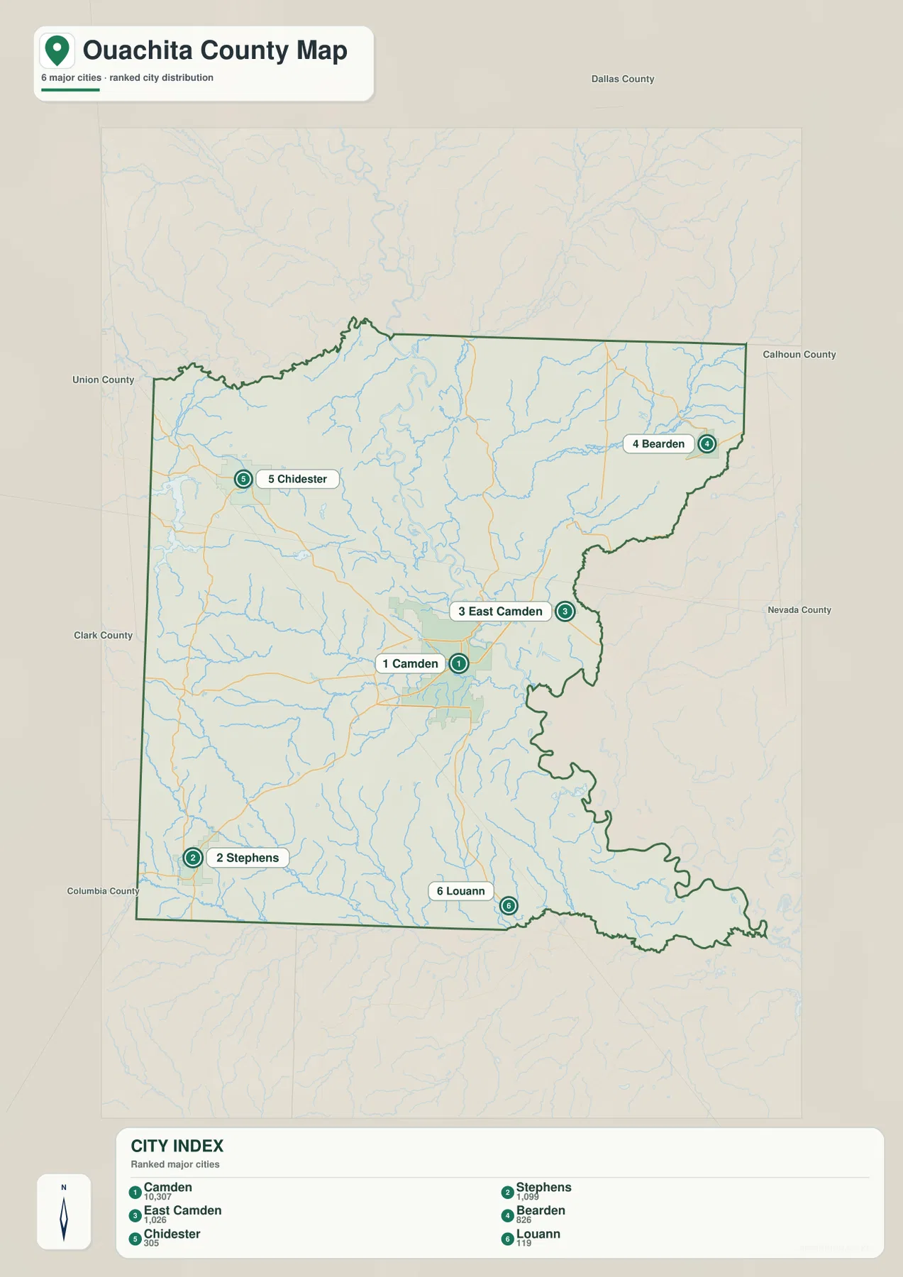
Camden and East Camden appear close together, but the water map shows how complicated the nearby river landscape is. The Ouachita River bends around the Camden side, and Toney Old River and Lower Old River are labeled just to the east. Bearden is closer to the Freeo Creek valley, while Stephens lies in the southwestern hill country near Gum Creek and Smackover Creek. The city points therefore represent noticeably different terrain and water settings even when they belong to the same county.
The city legend also includes numeric values beside the community names, but this article does not reinterpret those figures as current population estimates. The supplied map clearly supports the ranking and locations of the six communities, so those are the facts used here. Current population totals should be checked against recent Census data. Camden’s status as county seat is supported separately by county-specific reference material.
Ouachita River bends and old channels define the low country east of Camden
The Ouachita River is the strongest water feature on the terrain and water map. It curves around the Camden area and continues south through the low central-eastern part of the county. County reference material also describes Camden as a river city positioned on a large horseshoe bend. Toney Old River and Lower Old River are labeled nearby, giving the map a useful glimpse of former or secondary river channels alongside the main course.
The Little Missouri River follows the northern side, with Tate Lake just to the south. Saxon Lake and Bragg Lake are labeled in the northwestern interior. Numerous small tributaries descend from the rolling western hills toward the lower middle of the county. This part of the water map becomes much easier to interpret when compared with elevation shading, because each creek occupies a lower green corridor between short ridges.
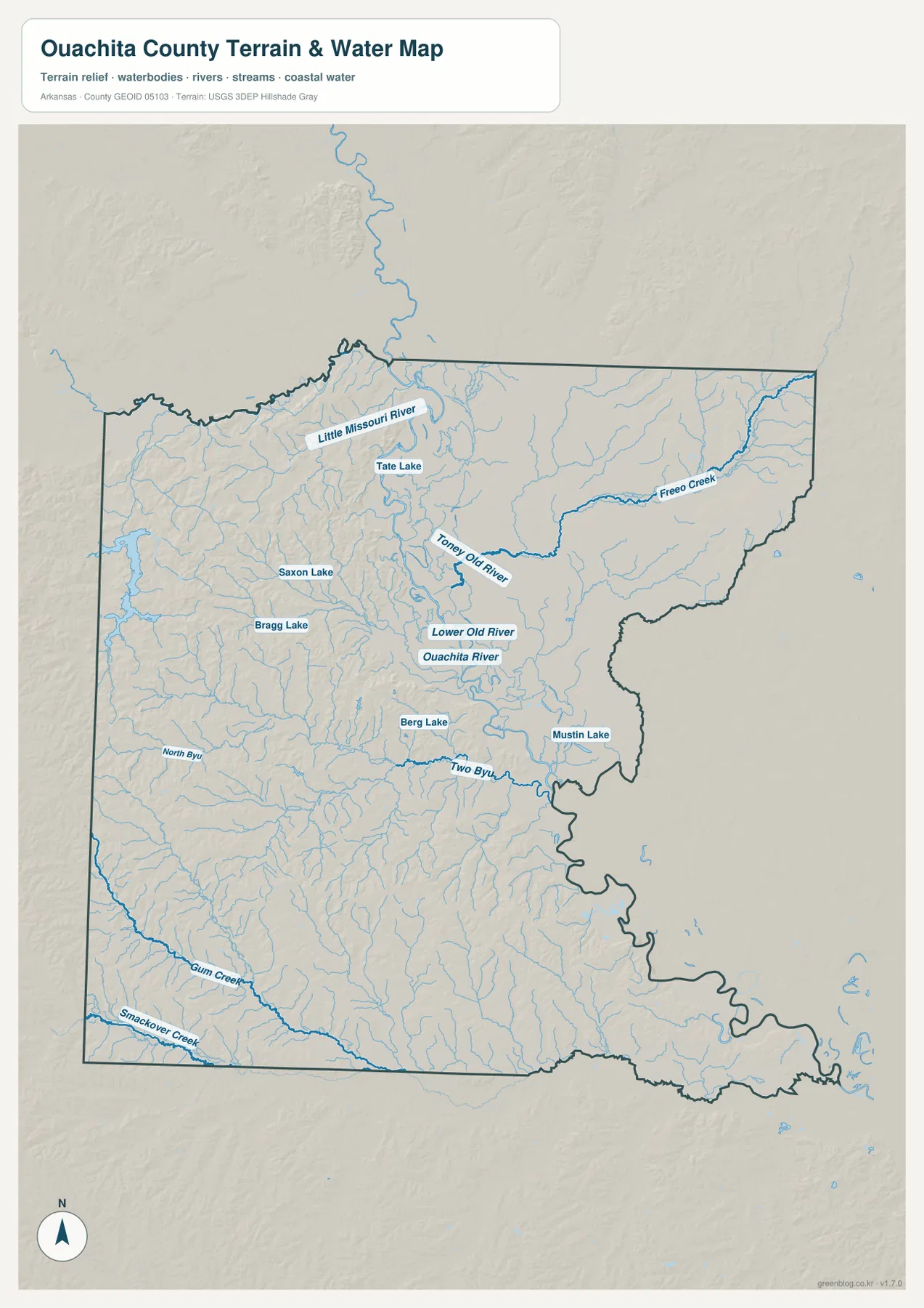
Freeo Creek crosses the northeastern side toward Bearden, while Two Bayou becomes a strong reference southeast of Camden. Berg Lake and Mustin Lake are labeled in the same broad lowland. Two Bayou approaches the irregular eastern county boundary and helps explain why that edge does not look like a simple straight line. The eastern half of Ouachita County is therefore a network of river bends, bayous, old channels, and smaller lakes rather than a single open floodplain.
North Bayou appears farther west, while Gum Creek and Smackover Creek cross the southwestern part of the county. These streams are smaller than the Ouachita River, but they occupy important low corridors through the rolling western terrain. This map is intended for general geographic reference. It does not provide current river stage, flood risk, boating conditions, property boundaries, or live road access. Current USGS and managing-agency information should be used for river, flood, or safety decisions.
Elevation falls from 124 meters in the western hills to broad river lowlands near Camden
The supplied elevation map shows an actual countywide range of about 23 to 124 meters, with a mean near 56 meters. That is roughly 101 meters of relief. Brown and tan rolling terrain is concentrated across the western half, especially the northwest and southwest, while broad green lowland spreads around Camden and across much of the east and southeast. The Ouachita River corridor is one of the lowest visible features on the map.
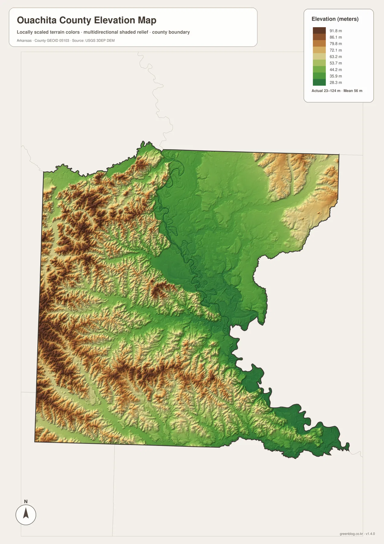
The northwest is strongly dissected by short ridges and creek valleys. Chidester and Reader are surrounded by more relief than Camden, and lower drainage corridors extend toward Saxon Lake, Bragg Lake, and the Little Missouri River side. The southwest around Stephens contains another wide area of rolling terrain, cut by Gum Creek, Smackover Creek, and many smaller tributaries. High ground is therefore broken into many separate ridges rather than forming one flat plateau.
Camden and East Camden sit in much lower terrain. Green shading follows the Ouachita River, Toney Old River, and Lower Old River, and the Bearden side remains comparatively low along Freeo Creek. The southeast becomes broad and flat before the boundary turns through low river country. The elevation map is most useful for seeing the overall west-to-east drop and the way creek valleys divide the western hills. Exact parcel, road, bridge, or building elevations require original USGS data or survey-grade measurement.
Compare Chidester and Bearden from Camden to see the county’s clearest terrain contrast
A practical way to use all four maps is to begin at Camden and compare west with east. Toward Chidester, Route 76 and the local road network move into more rolling terrain, with short ridges and tributaries appearing in quick succession. The elevation map changes from broad green lowland to tan and brown hills. Looking east through East Camden toward Bearden does the opposite: the Ouachita River lowland, old river channels, and the Freeo Creek valley keep the terrain much lower.
The southern towns add another useful comparison. Stephens lies beside the southwestern hill-and-creek landscape, while Louann is farther east near lower central-southern terrain. On the ranked city map they are simply separate points, but the terrain and water layers explain why their surroundings look different. Ouachita County becomes much easier to understand when Camden’s river bend is treated as the center and the rolling western half is compared directly with the lower eastern river plain.
The WebP images in the article are optimized for quick page viewing, while the download ZIP contains the same four maps as high-resolution JPG files. Each JPG measures 2572 × 3638 pixels in portrait orientation. Use the general map for Camden, East Camden, Bearden, Chidester, roads, and boundaries; the ranked city map for the six major communities; the terrain and water map for the Ouachita and Little Missouri rivers, creeks, bayous, and lakes; and the elevation map for comparing the county’s 23–124 meter relief.
Frequently Asked Questions
What is the county seat of Ouachita County?
Camden is the county seat. It sits beside a large bend of the Ouachita River and is the strongest road and settlement reference on the supplied map. Starting at Camden makes it easy to locate East Camden, Bearden, Chidester, Stephens, and the main river corridor.
Why is the Ouachita River so important on this county map?
The river bends around the Camden area and creates the broad lowland across the central-eastern county. Toney Old River and Lower Old River are also labeled nearby, showing how complex the local river landscape is compared with the rolling western hills.
Where is the higher terrain in Ouachita County?
The supplied elevation map shows the broadest higher terrain across the western and southwestern parts of the county. The actual range is about 23–124 meters with a mean near 56 meters. Camden, the Ouachita River corridor, and much of the east and southeast are substantially lower.
Map File Information
The ZIP contains the general county map, ranked city map, terrain and water map, and elevation map as high-resolution JPG files for printing or offline reference.
- File Type: ZIP containing 4 JPG files
Related Maps
Sources and references
- Encyclopedia of Arkansas – Ouachita County – Camden county seat, Ouachita River, and county geography
- Encyclopedia of Arkansas – Camden – Camden county-seat status and its position on an Ouachita River bend
- Encyclopedia of Arkansas – Ouachita River – Ouachita River route through southern Arkansas and Camden
- U.S. Census Bureau TIGER/Line Shapefiles – county boundary and road data
- USGS National Hydrography – rivers, creeks, bayous, lakes, and hydrography data
- USGS 3D Elevation Program – elevation and terrain data
Green Map creates custom-edited map images using open geographic data sources such as geoBoundaries, Natural Earth, OpenStreetMap, and government open data.
These maps are edited visual materials, not raw data files, and are provided for education, documents, presentations, and graphic reference.