Newton County in northwestern Arkansas is a rugged Boston Mountain county centered on Jasper, with steep ridges, deeply cut streams, and the Buffalo River crossing some of the most dramatic terrain on the map. Download the four high-resolution JPG maps on this page together in one ZIP file. The package includes the general county map, ranked city map, terrain and water map, and elevation map. Ponca lies in the northwest, Western Grove is far to the northeast, Mount Judea is east of the center, and Deer sits farther south. The supplied elevation map ranges from about 203 to 784 meters with a mean near 481 meters, showing just how much relief separates river valleys from the surrounding highlands.
Jasper is the county seat and the most useful reference point for reading the maps. The Encyclopedia of Arkansas describes Newton County as mountainous and rural within the Boston Mountains and identifies the Buffalo River and Little Buffalo River as major waterways. Its Jasper entry places the town along the Little Buffalo River. On the supplied road map, Jasper sits near the center-north and connects several routes leading toward Ponca, Western Grove, Mount Judea, Deer, and the more remote southern interior.
Table of Contents
Use Jasper to separate the Ponca, Mount Judea, and Deer road directions
Jasper is the clearest road anchor on the general county map. Northwest of town, Routes 74 and 43 lead toward the Ponca side, while Route 103 appears farther north through the highlands. East and southeast of Jasper, Route 374 and Route 123 cross another set of ridges toward Mount Judea. Continuing south brings the map toward Deer and eventually Route 7 in the southeastern part of the county. The routes bend often because the terrain rarely allows long straight lines.
The western and southwestern interior is even more sparsely settled. Route 327 appears near Wayton in the west-central section, and Routes 16 and 21 are labeled close to the southwestern boundary. These roads pass through repeated ridge-and-valley terrain rather than a regular road grid. In the far northeast, Route 65 provides a separate reference near Western Grove, showing how that community is connected from a different side of the county than Jasper and Ponca.
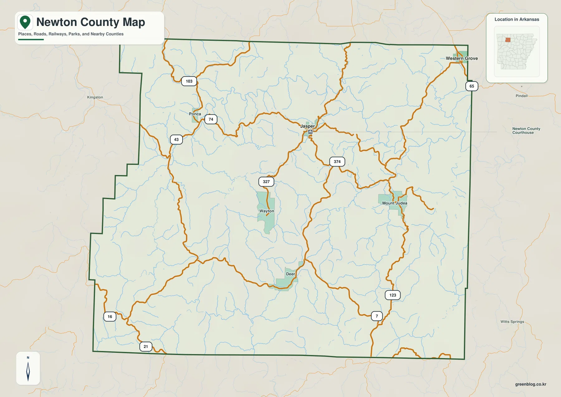
The county outline is also irregular. The western side contains several stair-step changes and the northern boundary includes projecting sections rather than a simple rectangle. Boone and Carroll counties lie to the north, Searcy County to the east, Marion County to the southeast, Pope and Johnson counties to the southwest, and Madison County to the west. That surrounding context places Newton County well inside the rugged Ozark interior instead of near a major urban plain.
The ranked city map shows Jasper and Western Grove as two widely separated centers
The city map ranks two major communities. Jasper is number 1 and Western Grove is number 2. These are ranking markers rather than distance labels. Jasper is close to the central-northern interior, while Western Grove sits near the northeastern boundary. A large area of mountain terrain and stream valleys separates the two, so the general road and elevation maps are important for understanding how different their practical connections can be from their simple point positions.
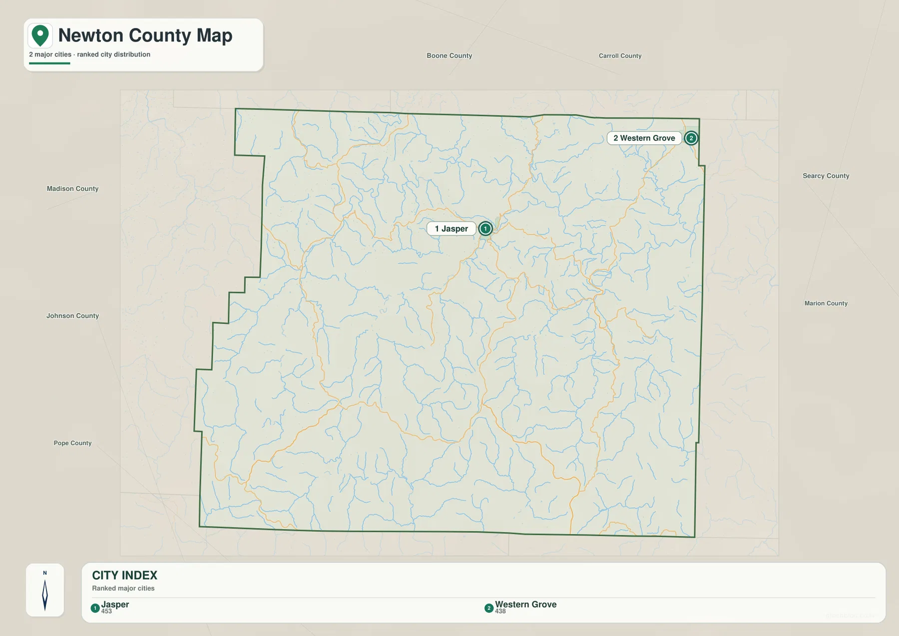
Several smaller map labels remain important even though they are not part of the two-city ranking. Ponca helps locate the upper Buffalo River area in the northwest, Mount Judea is a strong eastern road reference, Deer marks the southern interior, and Wayton helps orient the west-central section. The National Park Service identifies the Jasper and Ponca areas with the Upper District of Buffalo National River, reinforcing how closely those northwestern communities are tied to the river corridor.
The city legend also displays separate numeric values beside Jasper and Western Grove, but this article does not reinterpret those figures as current population estimates. The supplied map clearly supports the ranking and geographic positions of the two communities, so those are the facts used here. Current population totals should be checked against recent Census data.
Buffalo River and Little Buffalo River cut deep corridors through the mountains
The Buffalo River is the strongest water feature on the terrain and water map. It winds through the northern and eastern mountain country in a long series of bends, with tributaries descending from ridges on both sides. Newton County reference material also identifies the Buffalo River and Little Buffalo River as defining waterways of the county. The channel does not cross a broad flat valley; instead, it repeatedly turns between high terrain, producing the deeply cut landscape visible in the shaded-relief map.
The Little Buffalo River crosses the central part of the county toward the Jasper area, while the East Fork Little Buffalo River rises through a separate valley from the south. Those two waterways provide some of the clearest low corridors around the county seat. Numerous smaller streams descend from the western and southern highlands and join the system, so the water map reveals much more terrain structure than the road map alone.
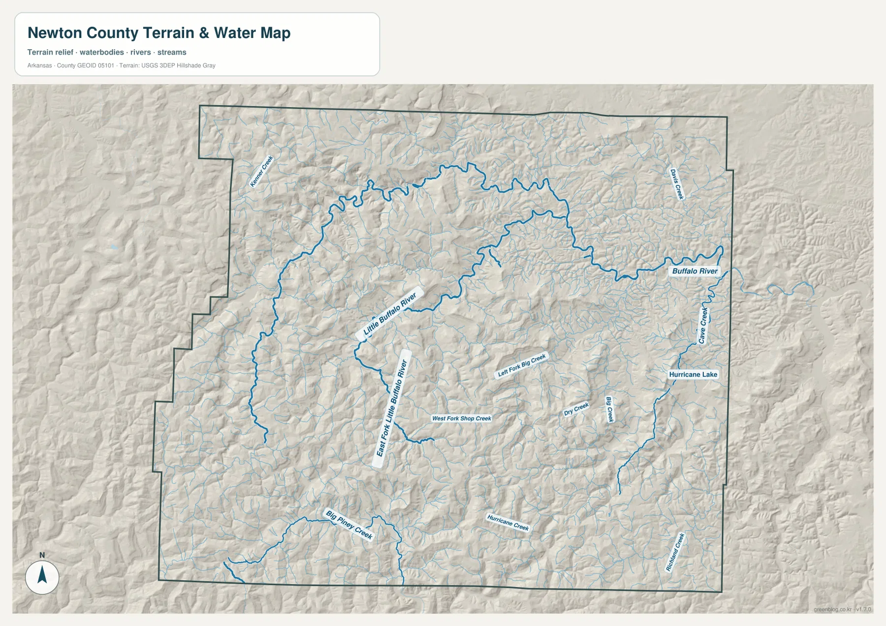
Big Piney Creek is labeled across the southwestern section, and Hurricane Creek crosses the south-central interior. West Fork Shop Creek, Left Fork Big Creek, Dry Creek, and Big Creek occupy separate valleys in the middle and east. Cave Creek lies near the Buffalo River side, and Richland Creek appears close to the southeastern boundary. Hurricane Lake provides a small named water landmark in the east-central area. Together, these streams show how thoroughly the county is divided by drainage corridors.
The terrain and water map is intended for general geographic reference. It does not show current river stage, flood or whitewater risk, hiking-trail conditions, private property boundaries, or live road access. The National Park Service specifically warns that navigation can be difficult in the Buffalo National River area, so current park directions and USGS information should be used for real travel or river-safety decisions.
Elevation rises from 203 to 784 meters across steep Boston Mountain relief
The supplied elevation map shows an actual countywide range of about 203 to 784 meters, with a mean near 481 meters. That is roughly 581 meters of relief. Dark brown highlands dominate much of the west, northwest, and southwest, while green low corridors follow the Buffalo River, Little Buffalo River, and other major streams. The eastern and northeastern side contains many lower valleys as well, creating a dense branching pattern rather than one simple high side and low side.
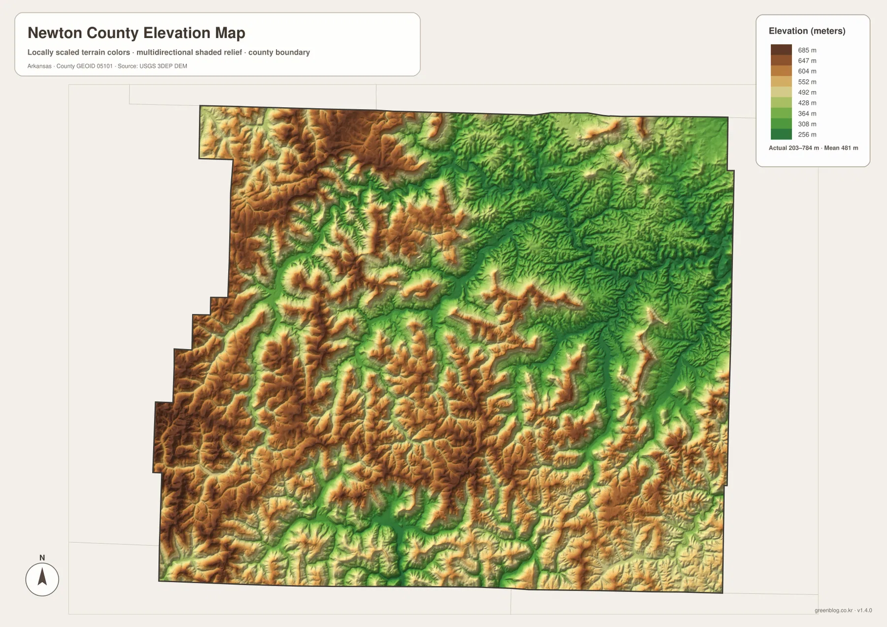
The Ponca side shows the contrast especially clearly. High ridges stand immediately beside the lower Buffalo River corridor, producing rapid changes from brown to green over short distances. Jasper is not on broad flat ground, but the Little Buffalo River creates a lower route through the surrounding mountains. Roads use many of the same valleys and lower passes, explaining why they curve so strongly around the terrain.
The southwest and south contain another large concentration of high ridges, broken by Big Piney Creek, Hurricane Creek, and many smaller tributaries. The Mount Judea side remains strongly dissected as well, with streams descending toward the Buffalo River system. The elevation layer is most useful for following the repeated ridge-and-valley pattern rather than locating one isolated summit. Exact parcel, road, or building elevations require original USGS data or survey-grade measurement.
Compare Ponca and Mount Judea from Jasper to see two different mountain corridors
A practical way to use all four maps is to begin at Jasper and compare the northwest with the east. Toward Ponca, Routes 74 and 43 move into high terrain close to the Buffalo River, and the elevation colors change sharply around the river valley. The National Park Service treats the Jasper-Ponca area as part of the Upper District of Buffalo National River, making this direction especially useful for connecting the road and water maps.
The Mount Judea direction follows a different set of ridges and tributaries. Routes 374 and 123 cross the eastern interior, while small streams descend through deep valleys toward the Buffalo River system. Looking south toward Deer adds another comparison, with broad highlands cut by Hurricane Creek and other tributaries. These directions show why Newton County is best understood as a network of mountain corridors rather than a flat road grid.
The WebP images in the article are optimized for quick page viewing, while the download ZIP contains the same four maps as high-resolution JPG files. Each JPG measures 3638 × 2572 pixels in landscape orientation. Use the general map for Jasper, Ponca, Western Grove, and major roads; the ranked city map for Jasper and Western Grove; the terrain and water map for the Buffalo and Little Buffalo river systems; and the elevation map for comparing the county’s 203–784 meter relief.
Frequently Asked Questions
What is the county seat of Newton County?
Jasper is the county seat. It lies near the Little Buffalo River and is the strongest central road reference on the supplied map. Starting at Jasper makes it easier to locate Ponca, Western Grove, Mount Judea, Deer, and the main river corridors.
Do the numbers 1 and 2 on the city map show distance?
No. They are ranking markers used on the supplied city map. Jasper is ranked first and Western Grove second. Actual driving distance and travel time depend on winding mountain roads and should be checked with a current road or navigation map.
Where is the highest terrain in Newton County?
The supplied elevation map shows broad high terrain across the west, northwest, and southwest. The actual countywide range is about 203–784 meters with a mean near 481 meters. Lower green corridors follow the Buffalo River, Little Buffalo River, and many tributary valleys.
Map File Information
The ZIP contains the general county map, ranked city map, terrain and water map, and elevation map as high-resolution JPG files for printing or offline reference.
- File Type: ZIP containing 4 JPG files
Related Maps
Sources and references
- Encyclopedia of Arkansas – Newton County – Jasper county seat, Boston Mountains, Buffalo River, and Little Buffalo River background
- Encyclopedia of Arkansas – Jasper – Jasper county-seat and Little Buffalo River information
- National Park Service – Buffalo National River Directions – Jasper and Ponca access in the Upper District
- U.S. Census Bureau TIGER/Line Shapefiles – county boundary and road data
- USGS National Hydrography – rivers, streams, lakes, and hydrography data
- USGS 3D Elevation Program – elevation and terrain data
Green Map creates custom-edited map images using open geographic data sources such as geoBoundaries, Natural Earth, OpenStreetMap, and government open data.
These maps are edited visual materials, not raw data files, and are provided for education, documents, presentations, and graphic reference.