Nevada County in southwestern Arkansas is centered on Prescott and shaped by a mix of low river corridors and rolling Coastal Plain hills. Download the four high-resolution JPG maps on this page together in one ZIP file. The package includes the general county map, ranked city map, terrain and water map, and elevation map. The Little Missouri River follows much of the northern boundary, Terre Rouge Creek crosses the middle, and the Caney Creek–Cypress Creek system drains the southeastern interior. Smaller communities such as Emmet, Rosston, Willisville, Bluff City, and Bodcaw are widely separated across the county. The elevation map shows an actual range of about 44 to 157 meters with a mean near 89 meters.
Prescott is the county seat and the easiest place to begin reading the maps. The Encyclopedia of Arkansas places Nevada County in the West Gulf Coastal Plain and identifies the Little Missouri River as the major stream along the northern boundary with Clark and Pike counties. Both features are visible in the supplied maps. Prescott occupies the north-central road network, while the northern edge bends with the river. South of the city, the landscape becomes a repeating mix of low creek valleys and short ridges rather than one continuous flat plain.
Table of Contents
Prescott organizes the road map between Emmet, Bluff City, and the southern towns
Prescott is the strongest road reference on the general map. Routes 30 and 332 cross the western and central part of the city area, while Route 67 approaches from the Emmet side to the southwest. Route 372 runs south from the Prescott area and meets the road network leading toward Rosston and Willisville. Starting with these routes makes the county easier to read because several smaller roads branch away from the same north-central hub.
The eastern side has a separate set of landmarks. Route 24 reaches the Bluff City and Reader side, and Route 299 is labeled just to the south. Around Cale, Routes 19 and 200 cross the central-southern interior. Rosston also lies near Route 19, while Willisville is served by Routes 76, 32, and 371. Bodcaw occupies the southwest near Routes 4, 278, 53, and 355. These widely spaced communities show how the county road network spreads through rural terrain rather than forming one continuous urban corridor.
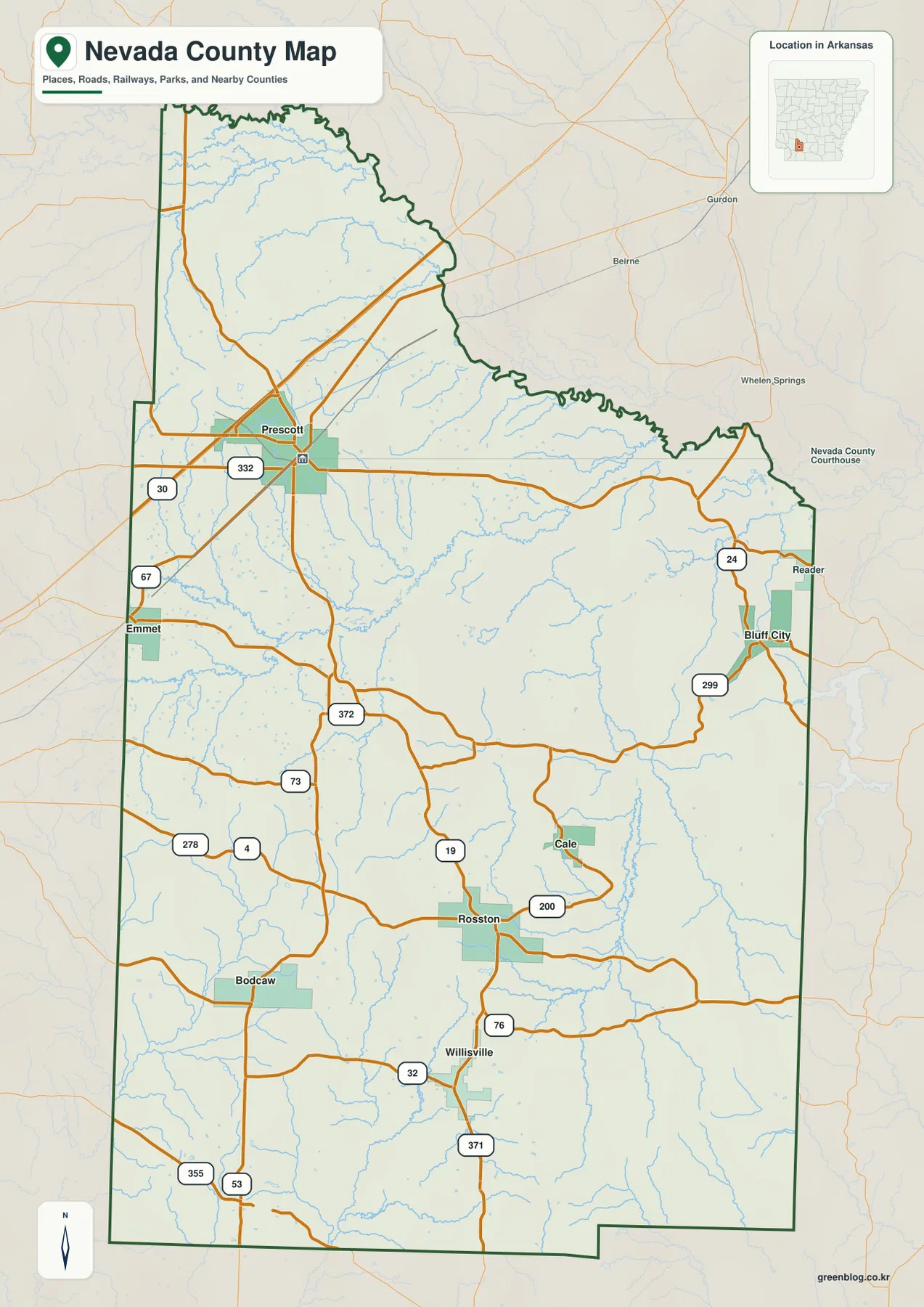
The county outline is especially irregular along the north. The Little Missouri River creates a long sequence of bends instead of a straight boundary, and the northeastern edge continues through smaller curves. The west and south contain longer straight segments by comparison. Hempstead, Pike, Columbia, Clark, Ouachita, and Lafayette counties are labeled around the map, placing Nevada County within the rolling lowlands of southwestern Arkansas.
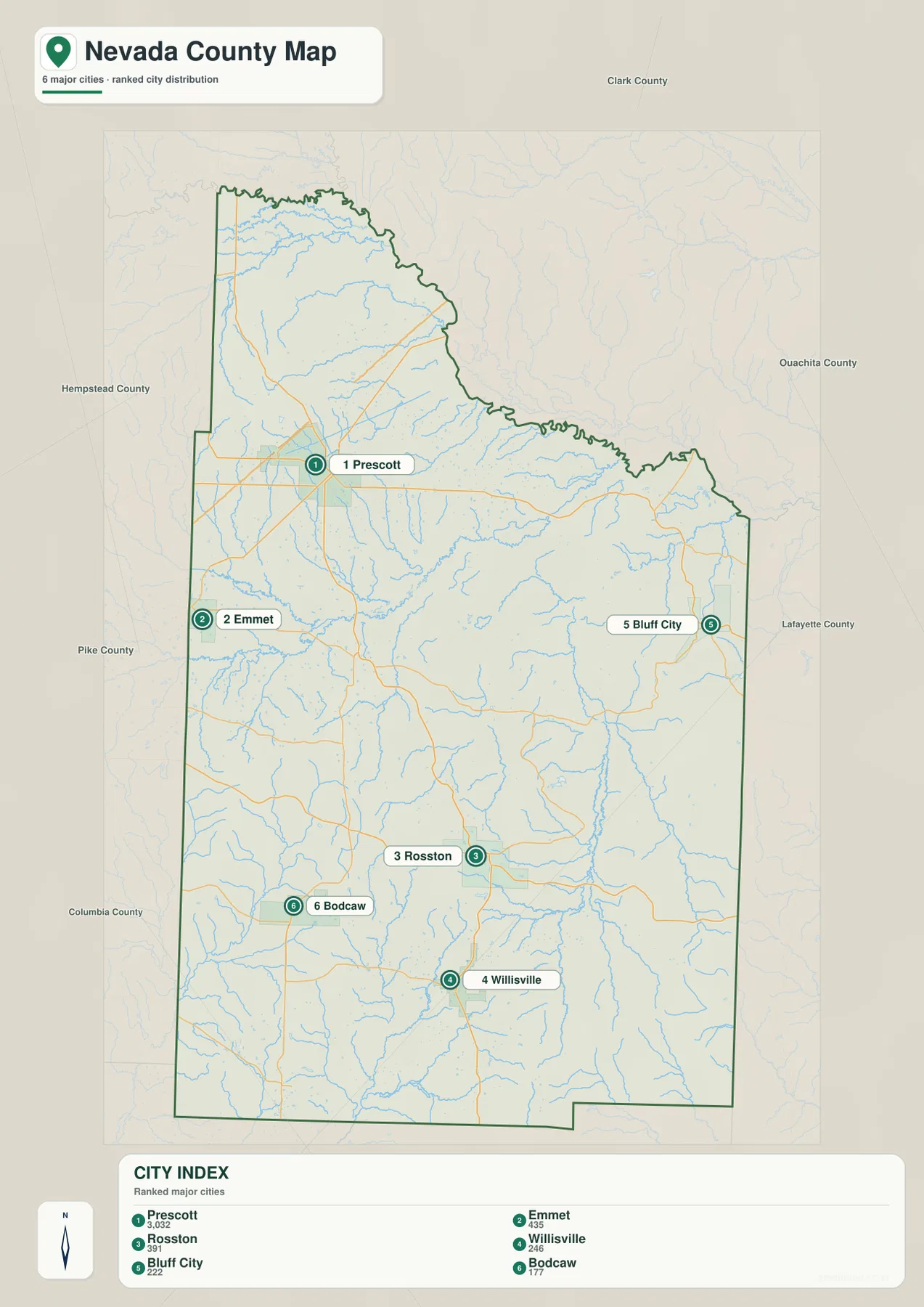
The ranked city map shows a Prescott center and smaller communities spread far apart
The city map ranks six major communities. Prescott is number 1, Emmet 2, Rosston 3, Willisville 4, Bluff City 5, and Bodcaw 6. These numbers are ranking markers rather than distance measurements. Prescott sits in the north-central section, Emmet is close to the western boundary, Bluff City is near the east, and Rosston, Willisville, and Bodcaw are distributed across the southern half. The map therefore shows a strong county-seat center surrounded by much smaller communities separated by broad rural areas.
The terrain map gives those locations more context. Prescott is close to higher rolling ground on its west and northwest, while creek valleys open toward the central interior. Emmet lies along another western road corridor surrounded by smaller drainage lines. Rosston and Willisville sit among the longer southern valleys, and Bluff City is closer to the Caney Creek and Cypress Creek side. The communities make more geographic sense when their road positions are compared with the water and elevation layers.
The city legend also includes numeric values beside the community names, but this article does not reinterpret those figures as current population estimates. The supplied map clearly supports the ranking and geographic positions of the six communities, so those are the facts used here. Current population totals should be checked against recent Census data. Prescott’s status as county seat is supported separately by county-specific reference material.
The Little Missouri River shapes the north while Terre Rouge Creek crosses the interior
The Little Missouri River is the most important water feature on the northern edge of the terrain and water map. It follows the county boundary through a long series of bends. Howard Creek and Brushy Creek occupy valleys in the northwest, and Black Creek reaches across the northern interior. Suckles Lake is also labeled in that area. County reference sources identify the Little Missouri as the major stream separating Nevada County from Clark and Pike counties to the north.
Across the middle of the county, Terre Rouge Creek becomes the clearest interior waterway. Little Terre Rouge Creek approaches from the west and joins the larger channel, which then winds northeast through the central landscape. On the general road map, the area southeast of Prescott can look like a broad rural block. The water map reveals that it is cut by a long creek valley and many smaller tributaries draining the surrounding rolling ground.
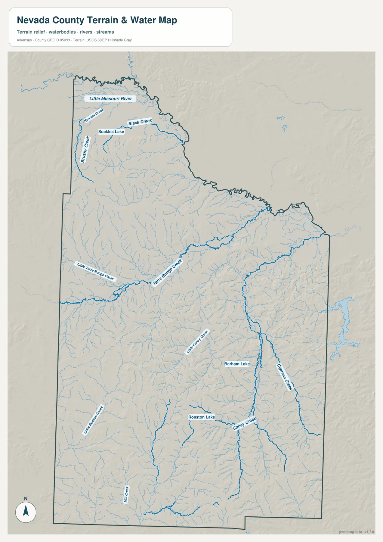
The southeastern half is organized around Caney Creek and Cypress Creek. Little Caney Creek approaches from the west, and Barham Lake is labeled nearby. Rosston Lake lies farther south and west, close to the road corridor through Rosston. Little Bodcaw Creek and Mill Creek occupy separate valleys in the southwest. Nevada County does not have one huge inland lake dominating the map; the water pattern is a dense network of creeks, tributaries, and smaller lakes spread between low ridges.
This terrain and water map is intended for general geographic reference. It does not provide current Little Missouri River or creek stage, flood risk, fishing regulations, property boundaries, or live road access. Stream conditions can change with rainfall. Current USGS and managing-agency information should be used for flood, recreation, or safety decisions.
Elevation ranges from 44 to 157 meters across alternating hills and creek valleys
The supplied elevation map shows an actual countywide range of about 44 to 157 meters, with a mean near 89 meters. That is roughly 113 meters of relief. The northwest contains the broadest concentration of tan and brown high ground, while another large group of ridges appears across the southwest and southern interior. Lower green terrain follows the Little Missouri River along the north and extends through several central and northeastern creek valleys.
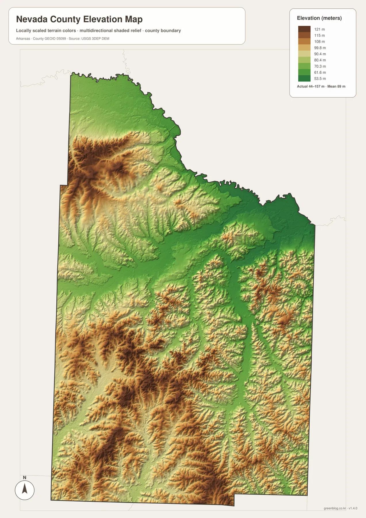
Prescott sits close to a noticeable transition. Higher ground rises to the west and northwest of the city, while the terrain falls toward the Terre Rouge Creek drainage farther southeast. The Emmet side also contains repeated short ridges and shallow valleys rather than a continuous high plateau. Green drainage corridors divide the higher colors into many separate pieces, which helps explain why roads curve and branch through the western interior.
The southern half remains rolling. Higher terrain appears around the Bodcaw side and between Rosston and Willisville, but Caney Creek, Little Bodcaw Creek, Mill Creek, and other streams cut long lower paths through the ridges. Bluff City is close to another group of rolling terrain on the eastern side. The elevation map is therefore most useful for following the repeated hill-and-valley pattern rather than looking for one dominant summit. Exact parcel, road, or building elevations require original USGS data or survey-grade measurement.
Compare the Little Missouri River and the southern creek country from Prescott
A practical way to use all four maps is to begin at Prescott and compare north with south. Looking north brings the county boundary directly to the Little Missouri River, where Howard Creek, Brushy Creek, Black Creek, and other tributaries meet lower green terrain. The elevation map shows the river corridor dropping below the nearby hills. The same irregular northern edge appears on the general and water maps, making the relationship between boundary and river especially easy to understand.
Looking south toward Rosston and Willisville produces a different pattern. The county boundary matters less than the interior creek network, and Terre Rouge Creek gives way to Caney Creek, Cypress Creek, and numerous smaller tributaries. Rosston Lake and Barham Lake provide useful water landmarks, while Bodcaw sits among higher southwestern ridges cut by Little Bodcaw Creek and Mill Creek. Comparing these directions shows Nevada County as a rolling Coastal Plain county whose communities and roads are closely tied to the many creek valleys.
The WebP images in the article are optimized for quick page viewing, while the download ZIP contains the same four maps as high-resolution JPG files. Each JPG measures 2572 × 3638 pixels in portrait orientation. Use the general map for Prescott, Emmet, Bluff City, roads, and boundaries; the ranked city map for the six major communities; the terrain and water map for the Little Missouri River, Terre Rouge Creek, Caney Creek, and lakes; and the elevation map for comparing the county’s 44–157 meter hill-and-valley relief.
Frequently Asked Questions
What is the county seat of Nevada County?
Prescott is the county seat of Nevada County. It is also the strongest north-central road reference on the supplied map, making it useful for locating Emmet, Bluff City, Rosston, and the Little Missouri River side of the county.
How does the Little Missouri River affect the county map?
The Little Missouri River forms much of Nevada County’s northern boundary with Clark and Pike counties. Its meanders create the irregular northern outline, while tributaries such as Howard Creek, Brushy Creek, and Black Creek occupy nearby valleys. The elevation map also shows the river corridor lower than much of the adjacent rolling terrain.
Where is the higher terrain in Nevada County?
The supplied elevation map shows the broadest higher areas in the northwest and across parts of the southwest and south. The actual countywide range is about 44–157 meters with a mean near 89 meters. Lower terrain follows the Little Missouri River and several major creek valleys.
Map File Information
The ZIP contains the general county map, ranked city map, terrain and water map, and elevation map as high-resolution JPG files for printing or offline reference.
- File Type: ZIP containing 4 JPG files
Related Maps
Sources and references
- Encyclopedia of Arkansas – Nevada County – Prescott county seat, West Gulf Coastal Plain setting, and Little Missouri River boundary
- Encyclopedia of Arkansas – Prescott – Prescott county-seat and regional transportation background
- Encyclopedia of Arkansas – Little Missouri River – Little Missouri River route and Nevada County boundary context
- U.S. Census Bureau TIGER/Line Shapefiles – county boundary and road data
- USGS National Hydrography – rivers, creeks, lakes, and hydrography data
- USGS 3D Elevation Program – elevation and terrain data
Green Map creates custom-edited map images using open geographic data sources such as geoBoundaries, Natural Earth, OpenStreetMap, and government open data.
These maps are edited visual materials, not raw data files, and are provided for education, documents, presentations, and graphic reference.