Johnson County sits in east-central Georgia, with Wrightsville serving as the county seat and the main reference point on these maps. The page brings together the county outline, labeled roads and communities, a city-connections view, named waterways, and a shaded elevation surface. Visitors who need files rather than an on-screen preview can also download the four map products as high-resolution JPGs in a single ZIP archive.
The maps are designed for general geographic orientation. They are useful when you want to place Wrightsville in relation to Kite and Adrian, follow the Ohoopee and Little Ohoopee river systems across the county, or compare the lower stream valleys with the higher ground between them. They do not replace parcel records, legal boundary surveys, live road information, flood maps, navigation charts, or site-specific elevation measurements.
Johnson County was established in 1858. Rather than repeating one map with different styling, the four views separate the information that is most helpful for different tasks. The county map gives the broadest orientation, the city view simplifies the relationship among the main labeled places, the terrain-and-water map names rivers and creeks, and the elevation view shows a countywide range of about 55 to 138 meters.
Table of Contents
Wrightsville as the county reference point
On the general county map, Wrightsville is positioned near the central part of Johnson County and is marked beside the county sheriff’s office symbol. Kite appears farther east, while Adrian is shown near the narrow southern end of the county. The outline is broad across the north and middle, then extends southward in a long projection, so the relationship between these places is easier to understand when the boundary is visible at the same time.
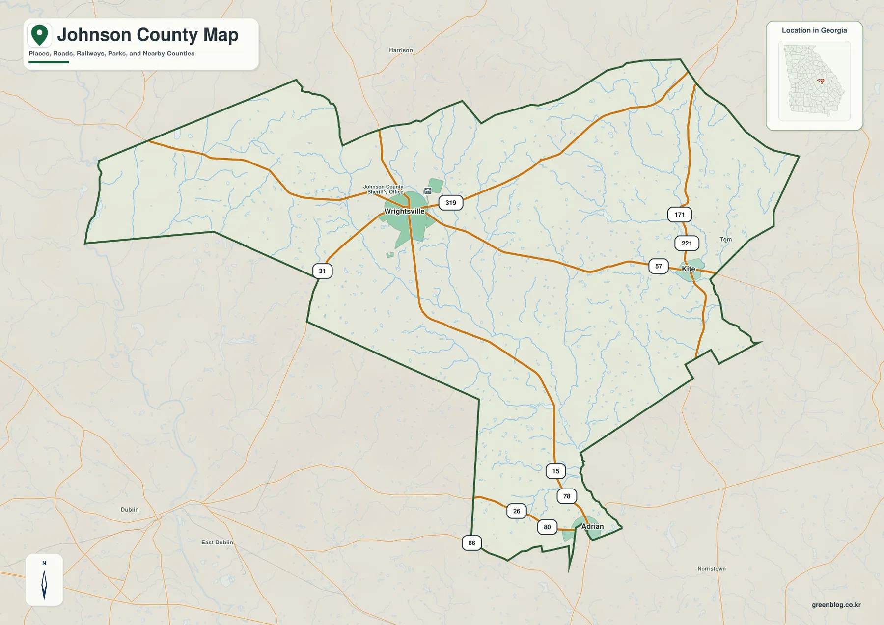
The surrounding basemap also includes nearby labels such as Harrison, Dublin, East Dublin, and Norristown. Those places help orient the county within the wider region, but the page is not intended to describe every road or settlement outside Johnson County. The darker county outline and the more prominent labels inside it should be the main guide when you are using this version for a report, classroom activity, or local-history reference.
Road numbers and the county edges
Several numbered routes provide useful visual anchors. The map shows 319 near Wrightsville, 57 continuing toward Kite, and 15 running south from the Wrightsville area. Other shields include 31 to the west, 171 and 221 on the eastern side, and 26, 78, 80, and 86 near Adrian. These labels make it easier to connect place names to the road pattern without turning the map into a detailed street atlas.
The city-connections view adds county names around the outer frame. Washington County and Jefferson County are labeled to the north, Emanuel County to the east, and Laurens, Wilkinson, and Treutlen counties to the west and southwest. Together, those names establish Johnson County’s position among the rural counties of east-central Georgia. For anyone comparing adjacent county maps, the frame is especially useful because it shows which direction to look next without crowding the interior with extra labels.
Road shields on a static reference map should not be read as live travel guidance. The map does not show closures, construction, speed restrictions, or the best current route between two addresses. Its job is simpler: it gives readers enough road context to understand how Wrightsville, Kite, Adrian, and the county boundary relate to one another.
Wrightsville, Kite, and Adrian on the city-connections map
The city map strips away much of the extra detail and treats Wrightsville as the hub. Kite is marked east of Wrightsville at about 12 miles, while Adrian is marked to the south at about 16 miles. Those figures are straight-line distances used to show geographic separation; they are not driving mileage. Road travel can be longer because an actual trip must follow the available road network.
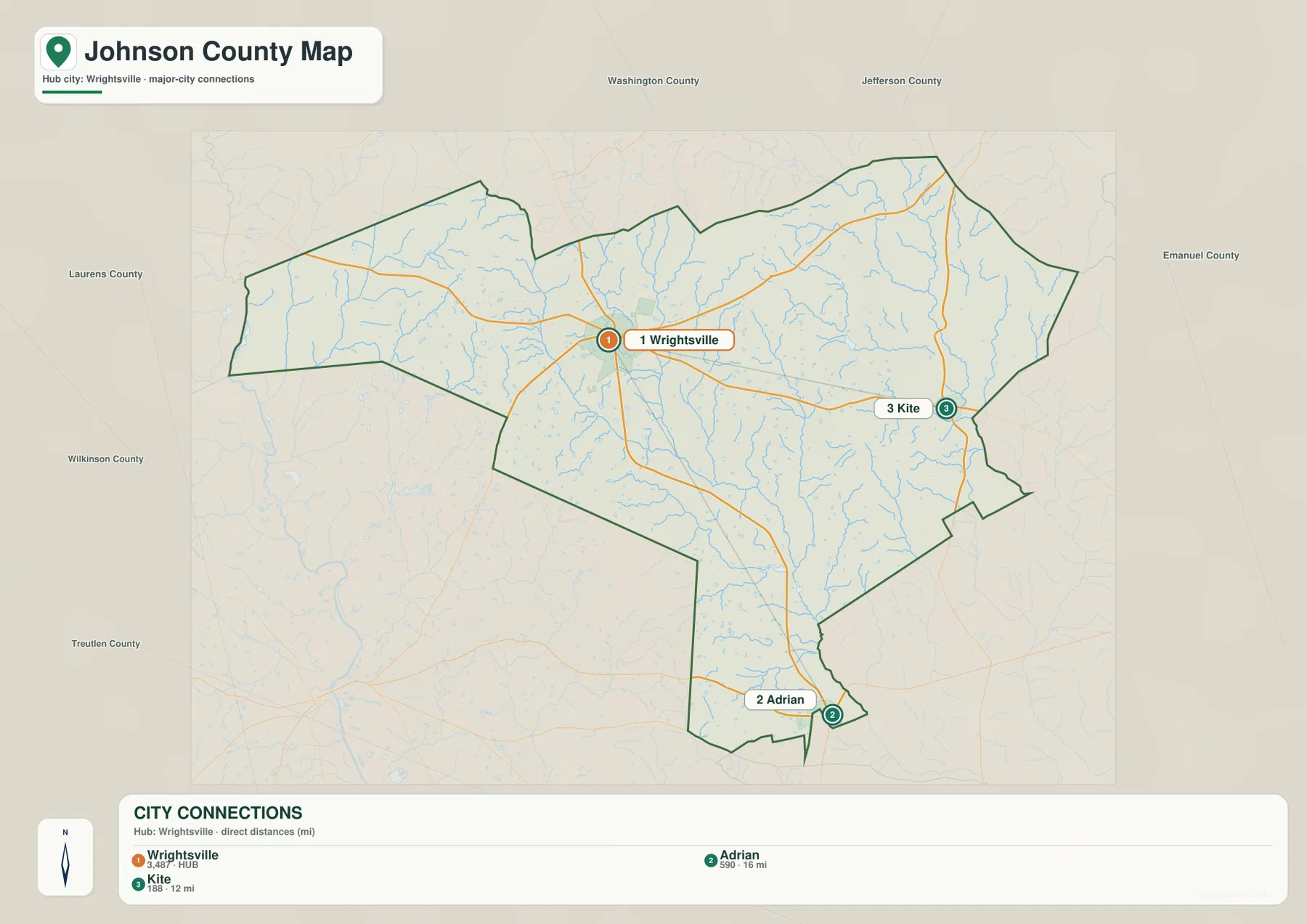
This simplified layout is helpful when the main question is not “Which stream crosses this road?” but “Where are the principal labeled communities in relation to the county seat?” It works well in a presentation or school project because Wrightsville, Kite, and Adrian can be explained without the viewer having to sort through every hydrographic line. It is also a useful companion to genealogy or historical research when a record names one of these towns and you want a quick sense of distance and direction.
The city map should still be treated as an orientation graphic. A straight line does not show the exact path a driver would take, and the map does not attempt to include every unincorporated community or service center. For turn-by-turn travel planning, a current road service is the better tool; for seeing the county’s internal settlement pattern at a glance, this version is deliberately simpler.
Ohoopee waterways, creeks, and ponds
The terrain-and-water map reveals how densely small streams cross Johnson County. The Ohoopee River is labeled through the central part of the county, while the Little Ohoopee River is prominent in the northeast. Between and around them are Big Cedar Creek, Cypress Creek, Neels Creek, and Big Beaverdam Creek. Hurricane Branch is labeled in the northeast, and the western side includes Buckeye Creek and Fords Creek. Dry Creek appears farther south.
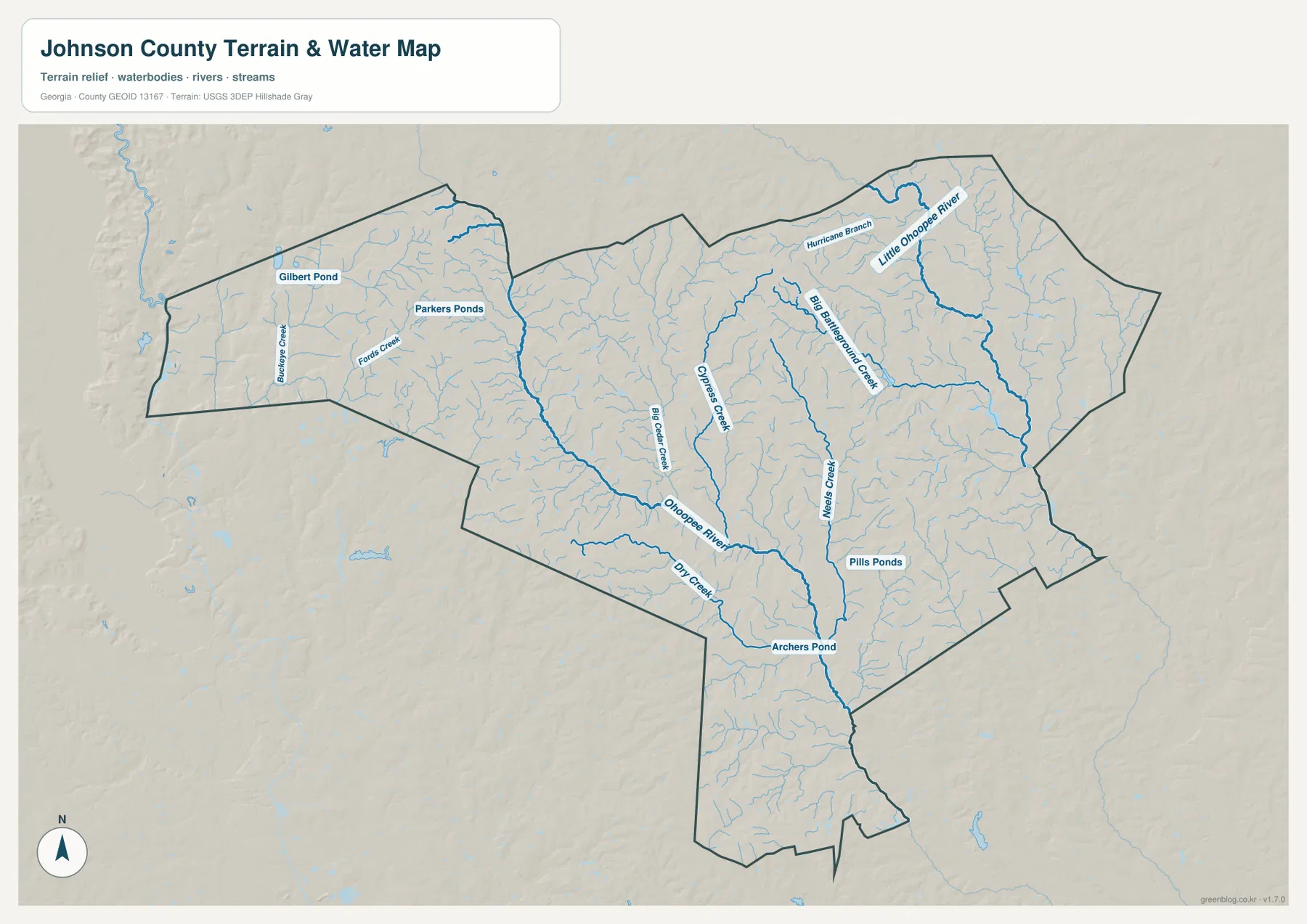
The map also identifies several ponds: Gilbert Pond and Parkers Ponds in the northwestern area, Pills Ponds in the south-central area, and Archers Pond near the lower part of the Ohoopee system. These smaller names add local detail that is not easy to pick out on the general road-and-boundary map. When the water map is compared with the elevation view, the stream corridors also help explain why long lower bands appear between higher ridges.
This is a water-reference map, not a flood-risk product. A river or creek symbol does not tell you whether a particular property floods, and the line width is not a measurement of channel width or depth. The map also does not establish public access, boating suitability, fishing rights, or parcel ownership around a pond. Its purpose is to show the named surface-water features and their position within the county boundary.
Elevation from about 55 to 138 meters
The elevation map gives Johnson County an actual mapped range of roughly 55 to 138 meters and lists a mean elevation of 94 meters. That range is modest compared with mountainous parts of Georgia, yet the shaded surface shows plenty of local relief. Green areas trace lower valleys, while tan, orange, and brown areas mark comparatively higher ground and narrow ridges between drainage lines.
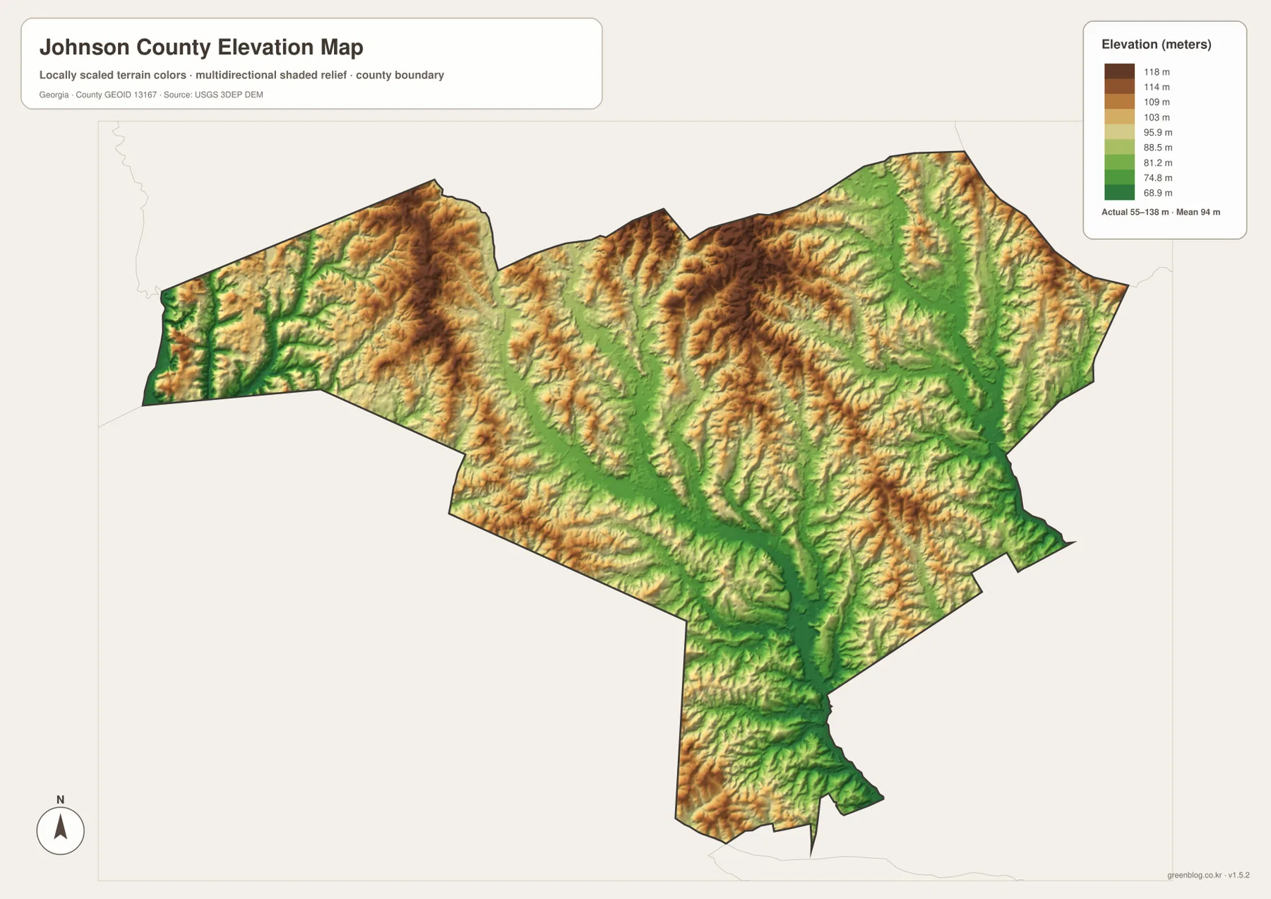
The relationship with the water map is especially clear in the central and eastern parts of the county. Long green corridors follow the lower ground associated with major streams, while higher shaded ridges occupy the areas between them. Similar contrasts appear in the southern extension of the county, where drainage lines cut through higher surrounding terrain. The result is a landscape that looks gently rolling and dissected rather than uniformly flat.
The elevation surface is generalized for countywide reference. It is appropriate for comparing higher and lower portions of Johnson County, but it is not survey-grade or engineering-grade data for a building site, road project, drainage design, or property decision. If a task depends on the precise elevation of a point, use a detailed official dataset or a professional survey instead of reading a value from this overview graphic.
Choosing the map that fits the task
The general county map is the best starting point when you need boundary, place, road, and stream context together. The city-connections map is cleaner when a presentation only needs the relationship among Wrightsville, Kite, and Adrian. For natural features, the water view provides the most detailed names, while the elevation view is better for comparing valleys and higher ground. Using two maps side by side can often answer a question more clearly than trying to force every detail onto one image.
- County orientation: use the general map for the outline, Wrightsville, Kite, Adrian, and numbered route context.
- Settlement comparison: use the city map for direction and straight-line distance from Wrightsville.
- Water features: use the terrain-and-water map for the Ohoopee system, named creeks, branches, and ponds.
- Terrain comparison: use the elevation map for the 55–138 meter range and the contrast between valleys and higher ridges.
The browser previews are optimized for quick viewing, but the downloadable files are the better choice for printing, archiving, or placing the maps in a larger document. The ZIP groups all four high-resolution JPG maps together so you do not have to save the preview images one by one. This also keeps the county, city, water, and elevation versions together when you return to the material later.
Frequently Asked Questions
What is the county seat of Johnson County?
Wrightsville is the county seat. It is the central reference point on both the general county map and the city-connections view, with Kite to the east and Adrian to the south.
Are the 12-mile and 16-mile city distances driving distances?
No. The city-connections map uses straight-line distances from Wrightsville: about 12 miles to Kite and about 16 miles to Adrian. Actual road mileage depends on the route and the exact start and end points.
Can the water map be used to determine flood risk or water access?
No. It is a geographic reference for rivers, creeks, branches, and ponds. It does not show regulated flood zones, water depth, navigation conditions, parcel ownership, or permission to enter land around a water feature.
Is the elevation map precise enough for surveying or engineering?
No. The shaded elevation surface is intended for countywide comparison of higher and lower terrain. Site-specific construction, drainage, or property work requires more detailed official elevation data or a professional survey.
Map File Information
High-resolution Johnson County map files
- Included Versions: County / City / Water / Elevation
Related Maps
Sources and reference limits
The following links provide county information and official sources commonly used for boundaries, hydrography, and elevation reference. They serve different purposes, so a legal, engineering, or property-specific question should always be checked against the most current source for that task.
- U.S. Census Bureau – Johnson County QuickFacts
- New Georgia Encyclopedia – Johnson County
- U.S. Census Bureau TIGER/Line Shapefiles
- USGS National Hydrography
- USGS 3D Elevation Program
Green Map creates custom-edited map images using open geographic data sources such as geoBoundaries, Natural Earth, OpenStreetMap, and government open data. These maps are edited visual materials, not raw data files, and are provided for education, documents, presentations, and graphic reference.