Jones County sits close to the geographic center of Georgia, northeast of Macon and west of Milledgeville. You can download four high-resolution A3 JPG maps in one ZIP from this page, with separate views for the county boundary and roads, Gray and surrounding counties, named waterways, and elevation. Gray is the county seat and the main city reference, while the western edge follows the Ocmulgee River for a substantial distance. Inside the county, a dense network of creeks crosses rolling ground before draining toward the larger Ocmulgee and Oconee river systems, so the four maps work well together for both quick reference and closer geographic comparison.
The maps are most useful when viewed together. The general county map shows where highways and selected communities sit within the boundary. The city map strips the view down to Gray and the surrounding counties. The water map brings smaller creeks and lakes forward, while the elevation map explains why those waterways occupy narrow valleys between ridges. Rather than presenting four versions of the same information, each map highlights a different part of Jones County’s geography.
Table of Contents
Where Jones County Fits in Central Georgia
Jones County was created in 1807 and is one of Georgia’s older counties. Gray has served as the county seat since 1905, replacing Clinton, an earlier center that was much more prominent during the nineteenth century. County history also includes communities such as Round Oak, Haddock, Wayside, Bradley, East Juliette, Griswoldville, and Clinton. Those smaller places matter because Jones County is not organized around a single large urban area; settlement is spread across a mostly rural landscape with Gray acting as the administrative and commercial anchor.
The county is surrounded by seven Georgia counties. Jasper and Putnam are to the north and northeast, Baldwin is to the east, Wilkinson and Twiggs are to the southeast, Bibb lies to the south, and Monroe is to the west. The Ocmulgee River forms much of the western county line. On a statewide map, this places Jones County in the central Georgia corridor between Macon and Milledgeville and across the transition known as the Fall Line, where the rolling Piedmont gives way toward lower terrain farther south.
| State | Georgia |
|---|---|
| County | Jones County |
| County seat | Gray |
| Created | 1807 |
| Land area | About 393.9 square miles |
| 2020 population | 28,347 |
| Download | Four high-resolution A3 JPG maps in one ZIP |
County Boundary, Gray, and the Main Road Network
The county reference map makes Gray the easiest place to orient yourself. It appears slightly south of the geographic center, where several important roads come together. U.S. Route 129 and Georgia routes 11, 18, 22, 44, and 49 are among the numbered routes shown. These roads fan out in several directions rather than following one straight corridor, which helps explain Gray’s role as the practical center for trips within the county and for connections toward surrounding parts of central Georgia.
Selected local labels provide additional reference points. Juliette and East Juliette appear near the western side of the county, Ethridge is shown toward the northeast, and Mountain Springs appears in the southeast. Places outside the boundary, including Smarr, Bolingbroke, Gordon, and Ivey, make it easier to see how the county relates to nearby communities. The map is designed as a county-level reference, so it should not be read as a complete street directory or a parcel map.
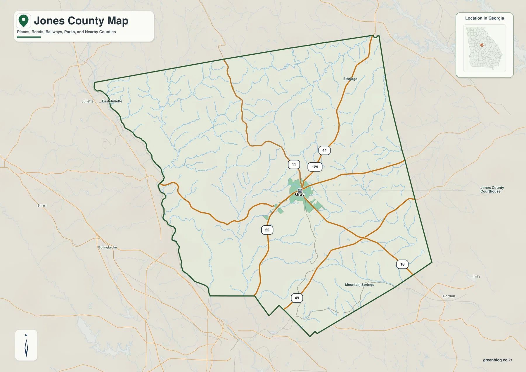
The western edge of the outline is noticeably more irregular than the straighter north and east sides. That shape reflects the natural river boundary along the Ocmulgee. For map readers, this is a useful visual clue: once you identify the winding western side, the position of Gray, Juliette, and the roads leading east and south becomes much easier to understand.
Gray as the Main City Reference
The city map intentionally avoids filling the county with every community name. Gray is the only ranked major city in the map’s city index, which keeps the focus on the county seat and makes the broader settlement pattern easier to see. The surrounding labels for Monroe, Jasper, Putnam, Baldwin, Wilkinson, Twiggs, and Bibb counties also help place Gray within a wider regional frame rather than treating it as an isolated point.
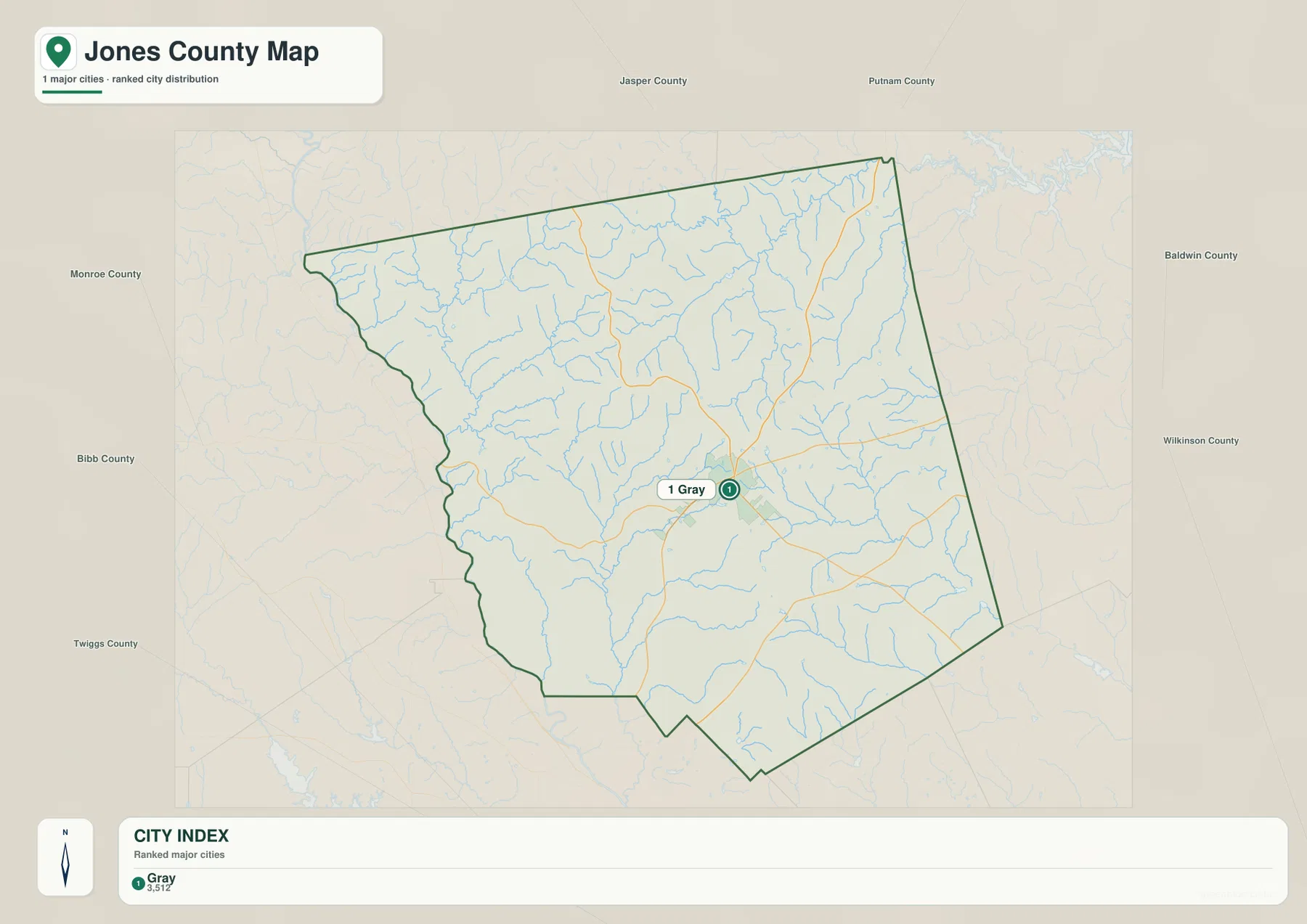
Gray became the county seat in 1905 after population and transportation patterns had shifted away from Clinton. The county’s history also includes rail-oriented and industrial places such as Griswoldville, while modern Jones County is closely connected with nearby Macon and Milledgeville. That background makes the simple city map more meaningful: Gray is not just the largest labeled point, but the place where county government, services, and several road connections are concentrated.
For local-history research, genealogy, or travel planning, it can be useful to pair this city view with the more detailed county map. The city map gives you the basic position of Gray, while the county map restores selected community names and numbered highways. Together they provide orientation without implying that every unincorporated settlement or local road has been mapped.
Creeks, Lakes, and the Western River Boundary
The water map changes the emphasis completely. Road labels fade into the background and the stream network becomes the main feature. Falling Creek runs along part of the western side, while Walnut Creek extends through the southwestern portion of the county. Farther north and east, Big Cedar Creek, Hog Creek, and Taylors Creek are labeled, and the southern half includes Rock Creek and Slash Creek. Numerous smaller tributaries branch away from these named streams, showing how thoroughly the county is divided by narrow drainage valleys.
Several lakes are labeled as local reference points: Allisons Lake in the northwest, Hungerford Lake farther east, Hodges Lake on the western side, and Bateman, Brasswells, and Polands lakes in the southern half. Lake Sinclair appears beyond the county near the northeast corner. That distinction matters because the map includes nearby water features for orientation; not every label lies inside the Jones County boundary.
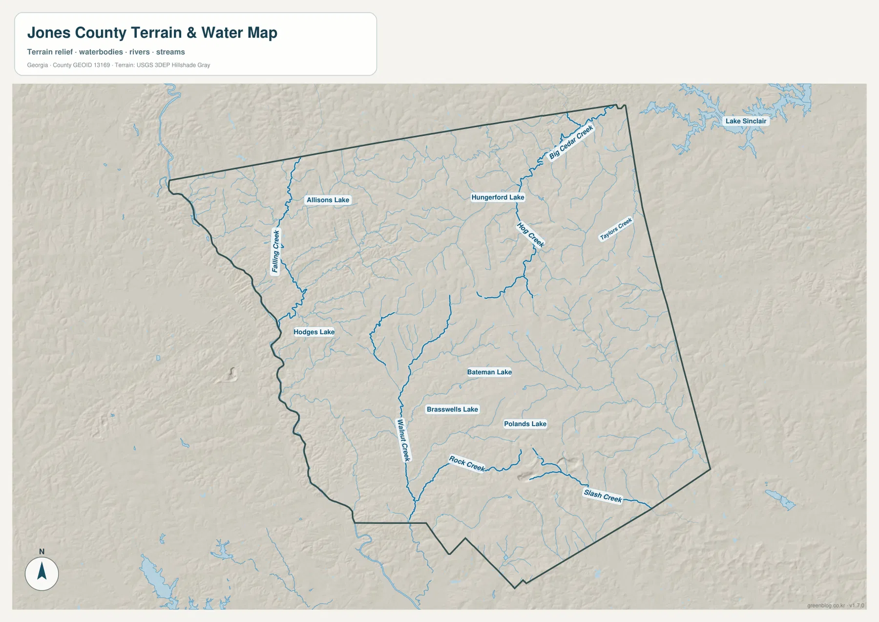
Jones County lies across the Fall Line transition, and the stream pattern reflects a landscape of rolling ridges and incised valleys rather than a flat plain. The Ocmulgee River is the major western boundary feature, while interior creeks drain different parts of the county toward larger river basins. This map is useful for geographic orientation, but it is not a flood-hazard, boating, water-quality, or legal riparian-boundary map. Those questions require current data from the appropriate public agency.
Elevation from River Valleys to Interior Ridges
The elevation map uses a locally scaled color ramp so that relatively small differences within Jones County remain visible. The legend reports an actual range of about 37 to 216 meters, with a mean elevation near 150 meters. Green areas mark lower ground, while tan, orange, and darker brown tones represent progressively higher terrain. This is not mountain relief, but the pattern of ridges and creek valleys is strong enough to shape the appearance of the county.
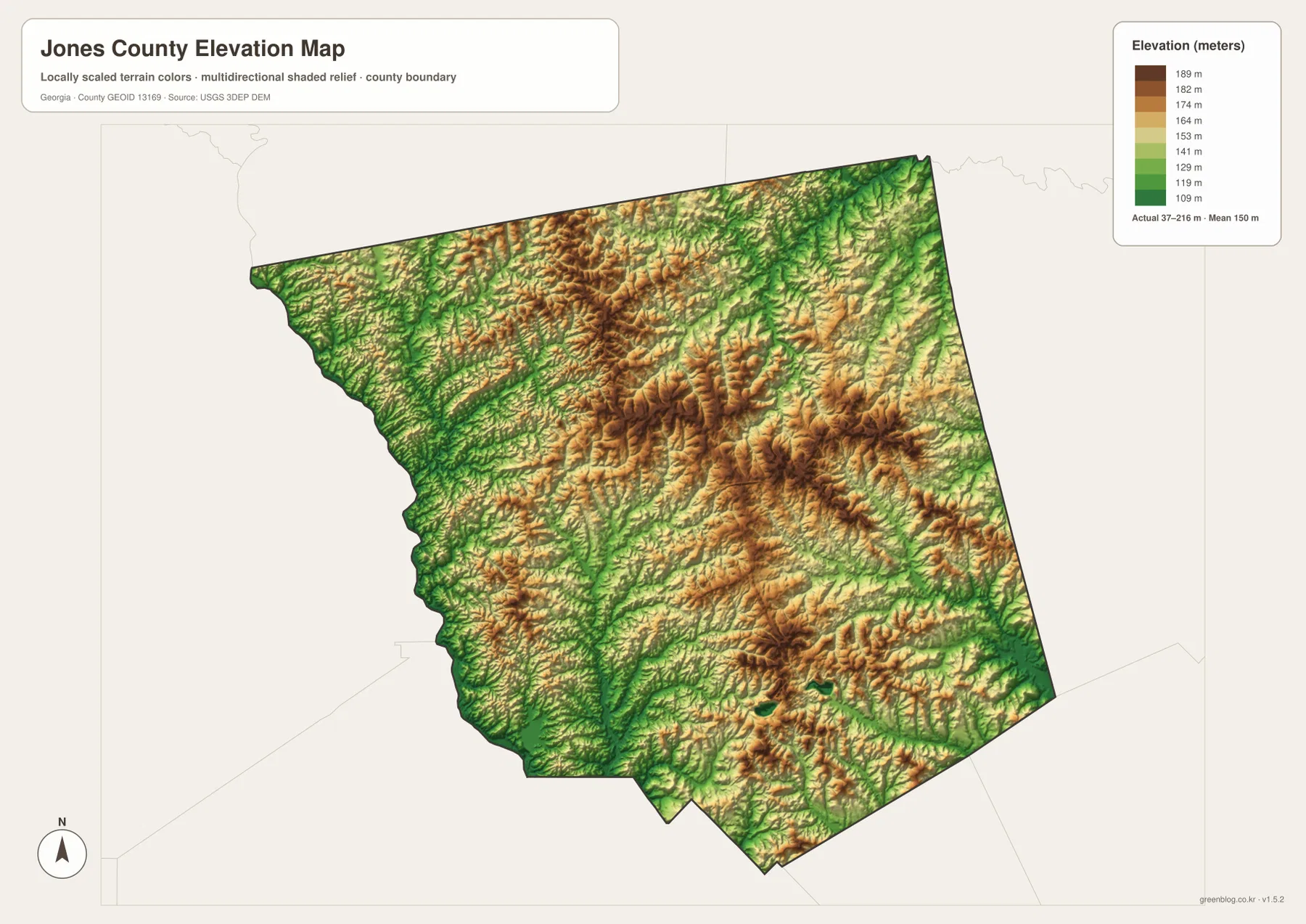
Lower terrain is especially visible along the western river side and along the branching creek valleys. Higher ridges occupy much of the interior, with repeated bands of warmer color extending through the central, northern, and eastern parts of the county. The relief map makes clear why the water network looks so complex: streams follow the low channels between many small ridges rather than crossing a uniformly level surface.
Because the colors are scaled specifically for Jones County, they should not be compared directly with colors on another county’s elevation map. A brown area here is simply high relative to other parts of Jones County. The numbers in the legend are the better reference when you need an actual height estimate.
Choosing the Right Map for a Project
Use the county map when you need the boundary, selected communities, and major routes on one page. The city map is better for a clean explanation of where Gray sits and which counties surround Jones County. The water map works well for stream and lake orientation, especially when you want to compare named creeks with the western river boundary. The elevation map adds the terrain needed to understand why those waterways follow particular valleys and why roads cross the county the way they do.
These maps can support classroom geography, county-history projects, genealogy notes, presentations, general travel orientation, and reports that need a clear location graphic. They are not substitutes for parcel surveys, legal boundary records, real-time navigation, flood insurance maps, emergency routing, or navigation charts. For those purposes, consult the responsible county, state, or federal agency and use the most current official dataset.
Frequently Asked Questions
What is the county seat of Jones County?
Gray is the county seat. It replaced Clinton as the seat of county government in 1905 and is the main city reference on both the county and city maps provided here.
Does the water map show the Ocmulgee River and every creek?
The Ocmulgee River is the key natural reference along much of the western county boundary, and the water map labels many important interior streams, including Falling Creek, Walnut Creek, Hog Creek, Big Cedar Creek, Rock Creek, and Slash Creek. It is a general reference map, however, and is not intended to show every minor drainage feature.
What elevation range is shown for Jones County?
The elevation legend reports an actual range of about 37 to 216 meters and a mean near 150 meters. The color ramp is scaled to Jones County, so use the legend values rather than comparing colors directly with another county map.
What is included in the downloadable ZIP?
The ZIP contains four high-resolution A3 JPG files: a county map, city map, water map, and elevation map. The images displayed in the article use WEBP for faster page loading, while the downloadable files are larger JPG versions intended for printing and offline use.
Related Maps
Sources and Reference Data
These links provide county background and the official geographic datasets used to check boundaries, hydrography, and elevation.
- U.S. Census Bureau QuickFacts – Jones County, Georgia
- Jones County Government – County History
- New Georgia Encyclopedia – Jones County
- U.S. Census Bureau TIGER/Line Shapefiles
- USGS National Hydrography
- USGS 3D Elevation Program
Green Map creates custom-edited map images using open geographic data sources such as geoBoundaries, Natural Earth, OpenStreetMap, and government open data. These maps are edited visual materials, not raw data files, and are provided for education, documents, presentations, and graphic reference.