You can download the high-resolution Hanson County map files on this page as one ZIP archive. Alexandria provides a useful starting point because Fulton lies to the north, Farmer to the northeast, and Emery toward the southeast, while the James River bends through the central and southern part of the county. The supplied maps separate roads and places, town-to-town straight-line distances, named waterways, and elevation so each layer remains easy to read.
Hanson County’s official About page describes a county about 18 miles from east to west and 24 miles from north to south, with Alexandria, Emery, Farmer, and Fulton as its four towns. Alexandria has served as the county seat since 1880. Those four places, together with the James River and the higher ground on the eastern side, give the county a clear set of landmarks that can be followed from one map to the next without treating the area as a simple rectangle of rural roads.
Table of Contents
Alexandria anchors the road network and the county outline
On the county map, Alexandria sits a little south of the county’s midpoint. Fulton is north of it, Farmer is northeast, and Emery is close to the southeastern side. Because the county is relatively compact and roughly rectangular in outline, finding Alexandria first makes it easier to keep track of which roads and place names belong inside Hanson County and which continue into the surrounding counties.
The road pattern is mostly a rural grid, but streams and other local features interrupt that grid in several places. Numbered markers visible on the map include 4 near Fulton, 17 and 38 in the east, 90 near the Alexandria latitude, 25 and 262 southeast of Alexandria, and 42 farther south. These labels are useful reference points on the supplied map, but the image is not a live road-status service, so current closures, construction, and turn-by-turn driving information should be checked separately.
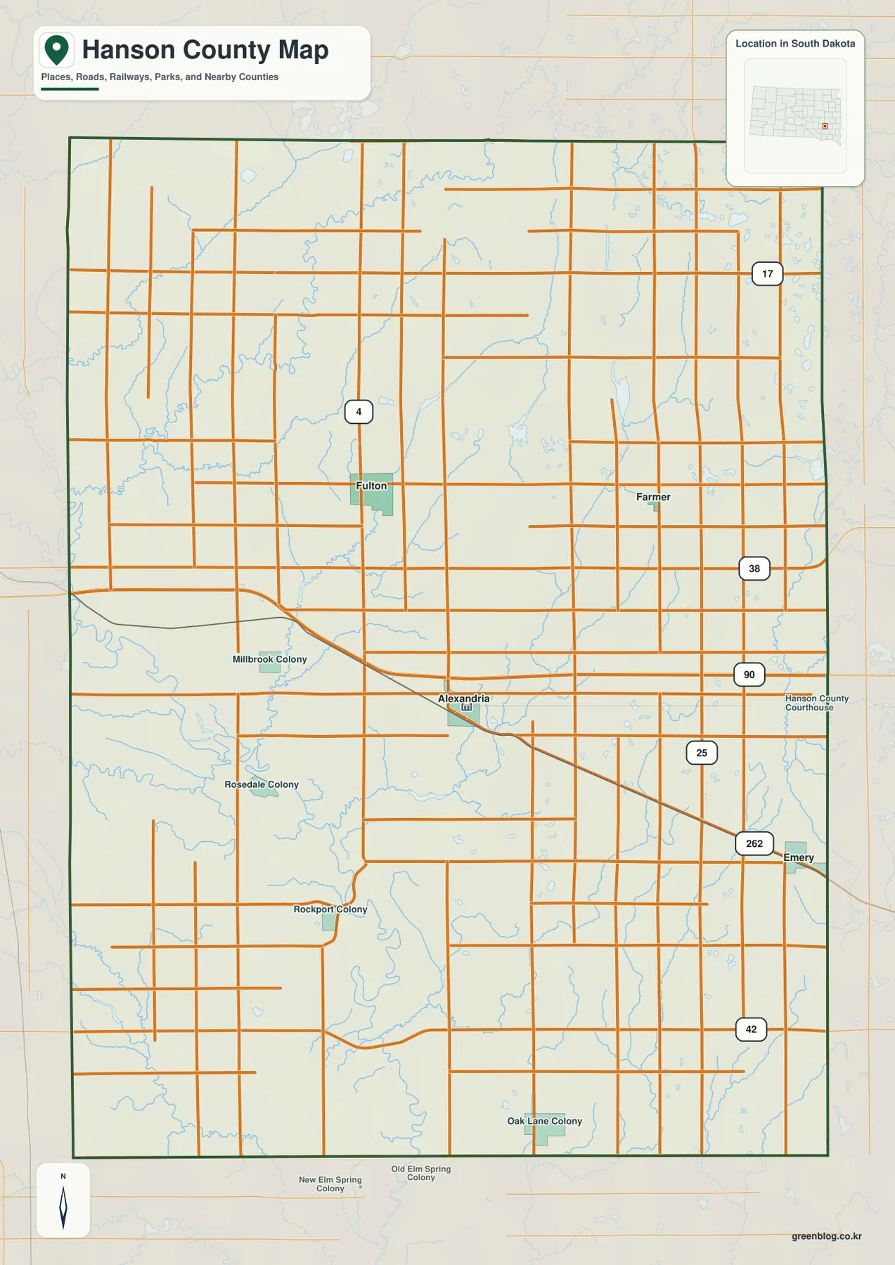
A railway crosses Alexandria and continues southeast toward Emery, adding another easy-to-follow line through the county. Smaller labels such as Millbrook Colony, Rosedale Colony, Rockport Colony, and Oak Lane Colony provide additional reference points beyond the four towns. These names are especially helpful when the main towns are too widely spaced to identify a location by town name alone.
The city map background also labels Miner County to the north, McCook County to the east, Hutchinson County to the west, and Davison and Sanborn counties toward the west and southwest. Those surrounding names make the Hanson County boundary easier to place within this part of South Dakota. Farmer and Emery are particularly useful eastern and southeastern reference points because both sit close to the county edge.
Fulton, Farmer, and Emery form three simple directions from Alexandria
The city-connections map removes most of the smaller road labels and focuses on the four towns. Alexandria is the hub, with Fulton directly to the north, Farmer to the northeast, and Emery to the southeast. That arrangement is useful when returning to the more detailed county map, because the three directions provide a quick mental guide for locating the same towns among roads, streams, and smaller place names.
The labels at the bottom of the city map give approximate direct distances from Alexandria: about 6 miles to Fulton, 7 miles to Farmer, and 9 miles to Emery. These are straight-line distances, not driving mileage. Actual road travel will normally be longer because a vehicle must follow the available road network rather than the direct connectors drawn between the towns.
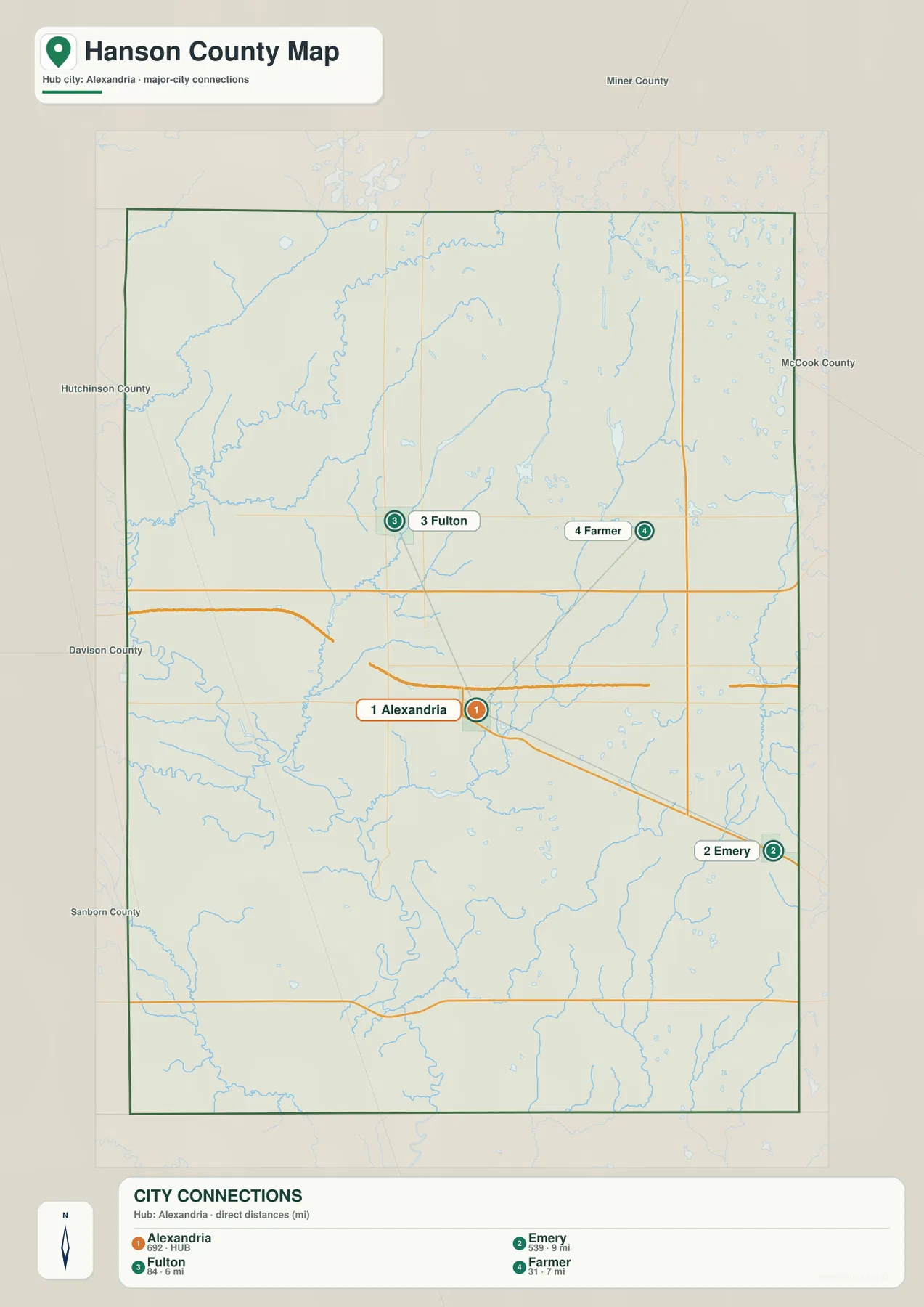
The official county profile and the map agree on the same four towns, which makes this simplified view a useful orientation tool. Alexandria is near the center and also serves as the county seat, while Fulton and Farmer define the northern half and Emery marks the southeastern side. Remembering those directions is often more useful than memorizing road numbers when moving between the city, water, and elevation maps.
This map does not attempt to show every local road, address, or small settlement. Its purpose is narrower: it shows how the four main towns are arranged and how far apart they are in a direct geographic sense. For driving routes, the detailed county map and a current road service are better choices; for waterways or relief, the other supplied maps provide clearer information.
The James River links a network of creeks and small lakes
The terrain and water map gives the James River the strongest visual emphasis. It enters from the western side, bends through the central part of the county, and continues south in a broad meandering course. Smaller blue lines join it from several directions, so the river is not an isolated feature but the main watercourse within a wider network of creeks and shallow drainage routes.
Rock Creek is prominent in the northwest, while Johnson Creek runs down from the Fulton Lake area toward the lower James River corridor. Pierre Creek lies east of the river and extends southward through the central-eastern part of the county. Farther east, Wolf Creek is labeled close to the boundary, and the southern half includes Bloom Creek and Plum Creek. Ethan Lake and Twelvemile Creek appear toward the southwest, adding more named water features beyond the James River itself.
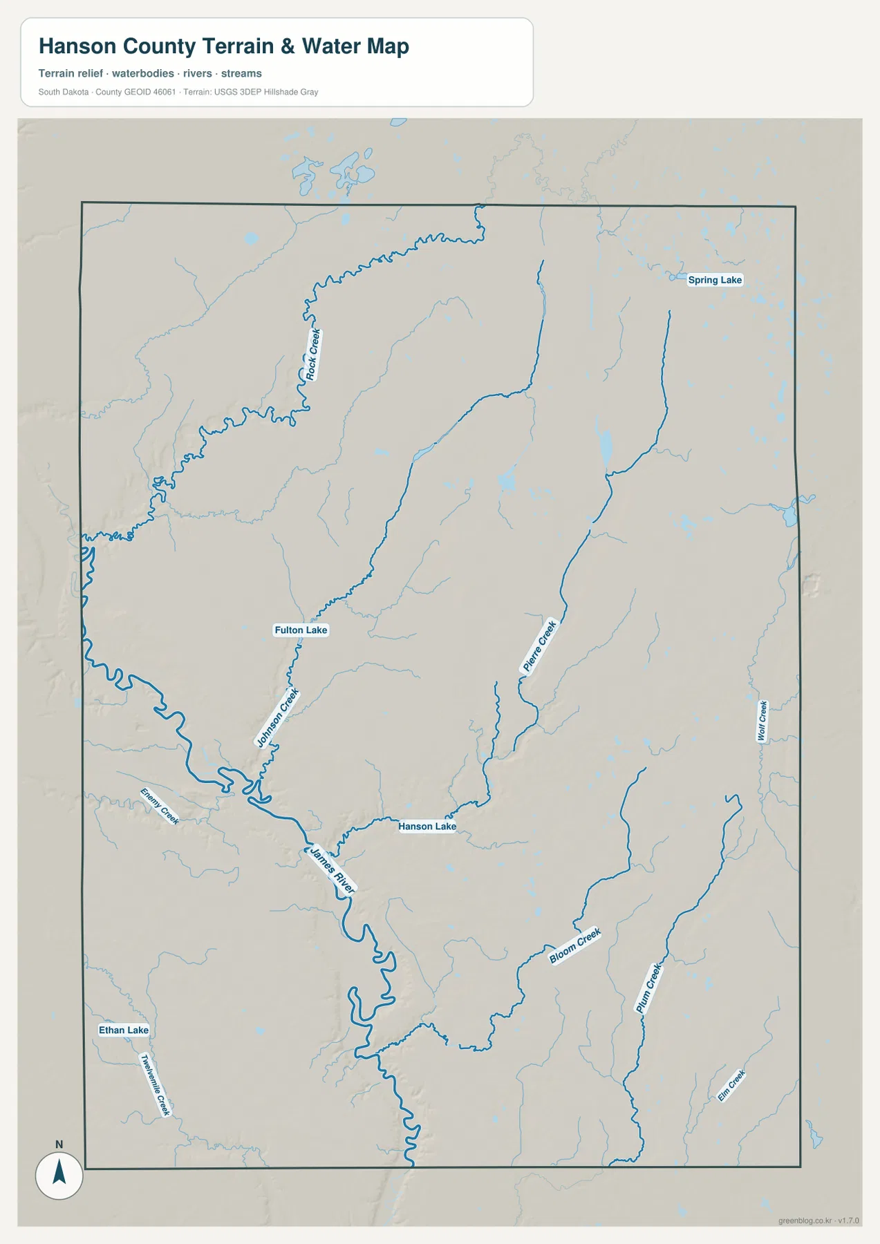
Hanson Lake is labeled near the central James River area, Fulton Lake is farther north, and Spring Lake appears in the northeast. The water map contains fewer town names than the road map, so it helps to use the county outline and the remembered position of Alexandria as reference points. That approach makes it easier to connect Fulton with the northern lake and creek area and to place the James River relative to the county’s central towns.
This is a reference map for locating rivers, creeks, and lakes. It does not show flood-risk zones, water depth, navigation channels, parcel ownership, or legal shoreline boundaries. Those questions require specialized sources. Here, the most useful reading is the location of the James River and the way named tributaries such as Rock Creek, Johnson Creek, and Pierre Creek approach the lower river corridor.
Eastern uplands stand above the low James River corridor
The elevation legend gives an actual county-wide range of about 364 to 443 meters, with a mean near 406 meters. Darker green follows the lowest parts of the James River valley through the center and south, while brown and orange cover much of the eastern and northeastern side. The difference is roughly 79 meters from the lowest to the highest values shown, enough to make the contrast visible even at the county scale.
The low ground branches away from the James River wherever tributaries cut into the surrounding land. Around Johnson Creek and other smaller streams, green corridors extend outward from the main valley. Rock Creek also sits in a lower path in the northwest. On the eastern side, Pierre Creek and other drainage lines appear as narrower lower strips within otherwise higher brown terrain, which closely matches the water features seen on the preceding map.
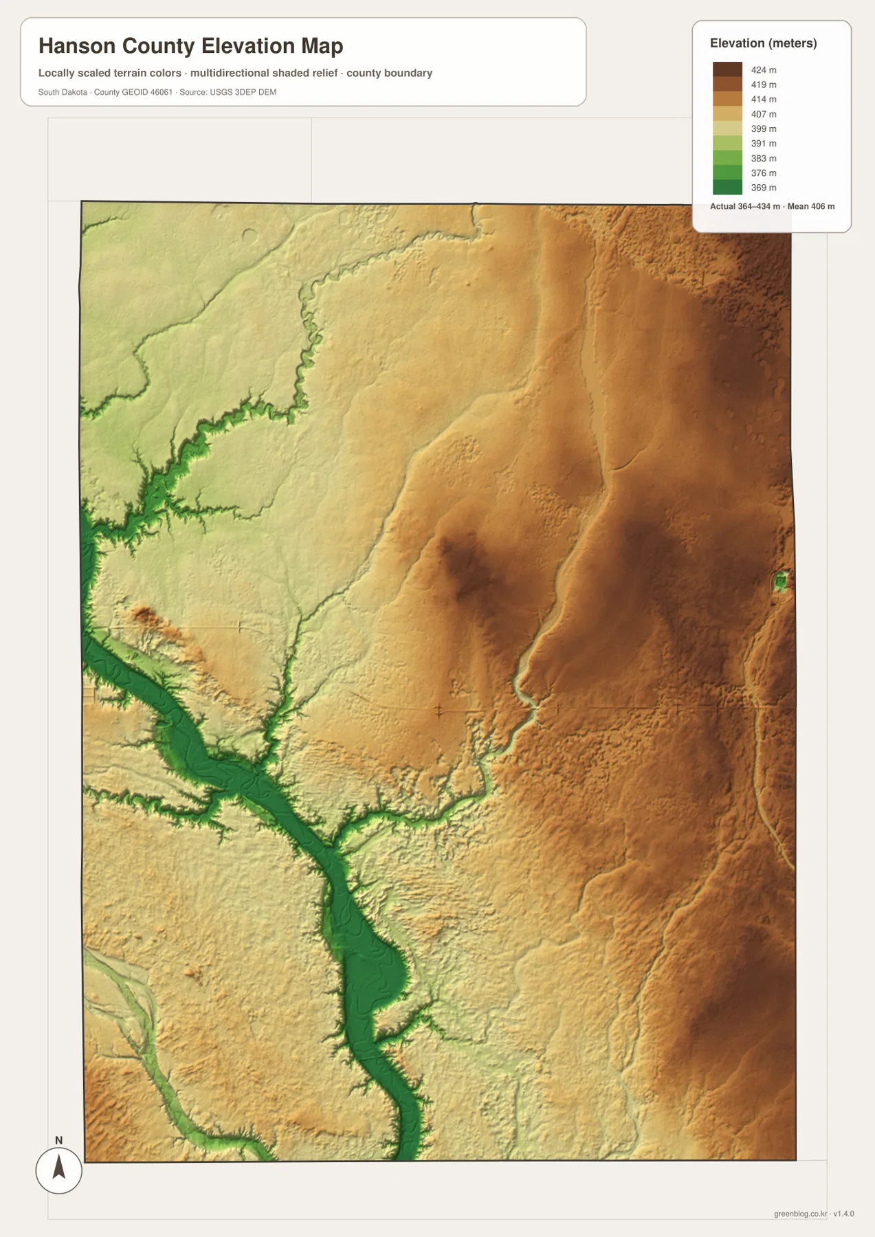
Town labels are not printed directly on the elevation image, so the map should not be used to read a precise elevation for Alexandria, Farmer, or Emery. Instead, match the county outline with the road map to compare broad relationships. Alexandria lies near the central river lowland, Farmer is in the higher northeastern part of the county, and the Emery area lies near a transition where higher terrain is cut by lower stream corridors.
The shaded elevation surface is intended for county-wide comparison rather than survey or engineering work. A building site, road grade, drainage project, or legal survey requires source elevation data and measurements appropriate to the project. For this page, the elevation map is best used to explain why the James River and its tributaries occupy lower bands while the eastern half of Hanson County appears noticeably higher.
Choose the Hanson County view that matches the question
If Hanson County is unfamiliar, begin with Alexandria on the road and place map, then trace the county boundary and locate Fulton, Farmer, and Emery. The city-connections image simplifies those relationships and confirms the 6-, 7-, and 9-mile straight-line comparisons. From there, the water map adds the James River and named tributaries, and the elevation map shows how the same river corridor sits below the higher eastern terrain.
Each map is stronger for a different task. The county map is the best starting point for numbered roads, the railway, colonies, and town locations. The city view is useful when only the four towns and their direct relationships matter. The terrain and water map is clearer for named creeks and lakes, while the elevation image is the most direct way to compare the James River lowland with the eastern uplands.
The WebP images on the page are reduced for convenient browser viewing. For larger labels, A3 printing, presentations, or offline reference, use the original JPG files in the ZIP below. The archive contains the road and place map, city-connections map, terrain and water map, and elevation map; each original image is 2572 × 3638 pixels.
Frequently Asked Questions
Do the 6-, 7-, and 9-mile labels from Alexandria show driving distances?
No. They are straight-line distances from Alexandria to Fulton, Farmer, and Emery. The city map shows about 6 miles to Fulton, 7 miles to Farmer, and 9 miles to Emery. Road mileage can be longer because drivers must follow the available roads rather than the direct lines drawn between the towns.
Which map should I use to find the James River, Fulton Lake, and Hanson Lake?
Use the terrain and water map first. It highlights the James River and labels Rock Creek, Johnson Creek, Pierre Creek, Fulton Lake, Hanson Lake, and other water features. To see whether those features lie in higher or lower terrain, compare the same county outline with the elevation map.
Is the 364–443 meter range precise enough for construction or surveying?
No. That range summarizes county-wide elevation and is intended for geographic comparison. It does not provide a survey-grade elevation for a parcel, road, or building site. Engineering, construction, drainage, and legal survey work should use suitable source elevation data and field measurements.
Map File Information
The ZIP below contains the original Hanson County road and place map, city-connections map, terrain and water map, and elevation map as four high-resolution JPG files.
- Included Files: 4 JPG maps
- Printable Size: 2572 × 3638 px each
Related Maps
Sources and references
- Hanson County, South Dakota – About – county dimensions, the four towns, and Alexandria’s role as county seat.
- South Dakota Legislature – Hanson County boundaries – the state statute describing the county boundary.
- U.S. Census Bureau TIGER/Line Shapefiles – official geographic reference data for boundaries and roads.
- USGS National Hydrography – official U.S. hydrography information for rivers, streams, and water bodies.
- USGS 3D Elevation Program – official USGS information about 3DEP elevation data.
Green Map creates custom-edited map images using open geographic data sources such as geoBoundaries, Natural Earth, OpenStreetMap, and government open data.
These maps are edited visual materials, not raw data files, and are provided for education, documents, presentations, and graphic reference.