You can download the Sumner County map files from this page as one ZIP containing four high-resolution A3 JPG images. The maps cover Gallatin, Hendersonville, Portland, Westmoreland, Old Hickory Lake, major roads, streams, and elevation, while the article explains how the lower southern lake area differs from the higher northern hills.
The county map quickly reveals that development is concentrated most strongly in the southwest and around Gallatin, while Portland and Westmoreland form separate northern centers. The water map adds the southern Old Hickory Lake shoreline and a branching network of creeks. The elevation map then explains a major physical contrast: the low southern lake country gives way to higher ridges and narrow valleys across much of the northern half of the county.
Table of Contents
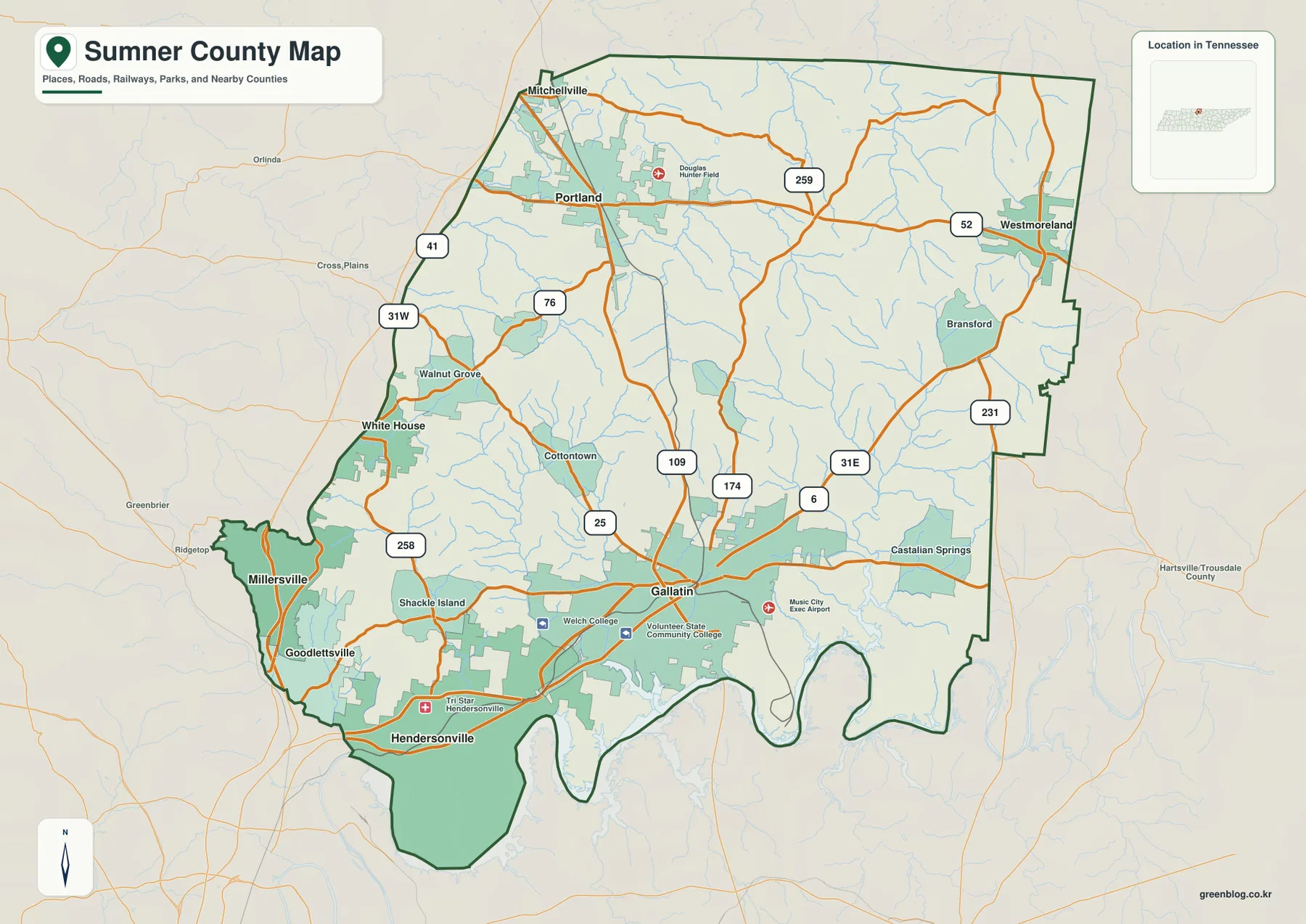
Gallatin and Hendersonville anchor the southern half of the county
Gallatin appears near the center of the developed southern half of Sumner County and serves as the county seat in the supplied reference material. Hendersonville lies farther southwest, close to the large reservoir shoreline. Goodlettsville and Millersville continue the cluster toward the southwest corner. Although these places form the county’s densest-looking urban area on the map, they are not arranged along a single straight line; water, road junctions, and the irregular southern boundary shape their positions.
Several major routes converge around Gallatin. The map labels 109, 25, 174, and 6 near the city, while 31E continues east and northeast through the Castalian Springs area. On the western side, 31W and 41 connect the White House and Portland direction. This road pattern makes Gallatin a useful central reference, but the county clearly has other corridors leading independently toward the northwest and northeast.
The surrounding labels provide useful regional orientation. Robertson and Davidson counties are west and southwest of Sumner County, while Wilson County meets the southern side. Trousdale, Macon, and Smith counties appear to the east. The northern edge reaches the Kentucky state line, so Portland and Westmoreland should be read not only as northern Sumner County communities but also as places close to an interstate boundary.
A southwest urban cluster, Gallatin in the middle, and two northern centers
The city map highlights six major city labels: Hendersonville, Gallatin, Goodlettsville, Portland, Millersville, and Westmoreland. Their positions tell a more useful story than a simple ranked list. Hendersonville, Goodlettsville, and Millersville sit close together in the southwest. Gallatin occupies a separate central-southern position, while Portland stands well to the northwest and Westmoreland is isolated in the northeast.
Hendersonville is ranked first by the city graphic and Gallatin second, yet Gallatin remains the county seat. That distinction is worth keeping in mind when using the map: the largest labeled city and the administrative center are not necessarily the same place. For government-related orientation, Gallatin is the key reference; for the largest urban concentration and the Old Hickory Lake shoreline, Hendersonville becomes equally important.
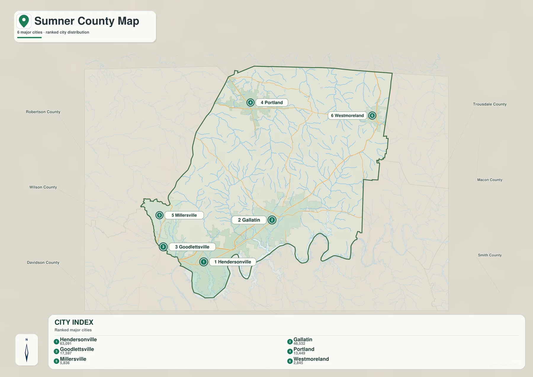
The existing county references list 196,281 residents in the 2020 census and a July 2025 estimate of 215,538. They also list about 529.5 square miles of land and 13.8 square miles of water. Those totals describe the county’s overall scale, but the city map makes clear that settlement is not evenly distributed. The concentration around Hendersonville and Gallatin contrasts with the wider spacing of places in the northern half.
Old Hickory Lake receives a web of streams from the interior
The water map is dominated by the reservoir shoreline along the southern edge of the county. The supplied title and county material identify this waterbody as Old Hickory Lake. Its shoreline is highly irregular, with long arms extending into the county south of Hendersonville and Gallatin. These inlets explain why the southern county boundary bends inward and outward so sharply instead of forming a simple line.
Several named streams descend toward this lower southern water system. Red River runs through the northwest, while Station Camp Creek and Drakes Creek cross the central-western area. Farther north, West Fork Drakes Creek, Caney Fork Creek, Sulphur Fork Creek, and Middle Fork Drakes Creek form a branching network. Bledsoe Creek is prominent on the eastern side, and the map also labels smaller lakes including City Lake, Willow Lake, Kirby Lake, Polk Lake, Crutcher Lake, and Anderson Lake.
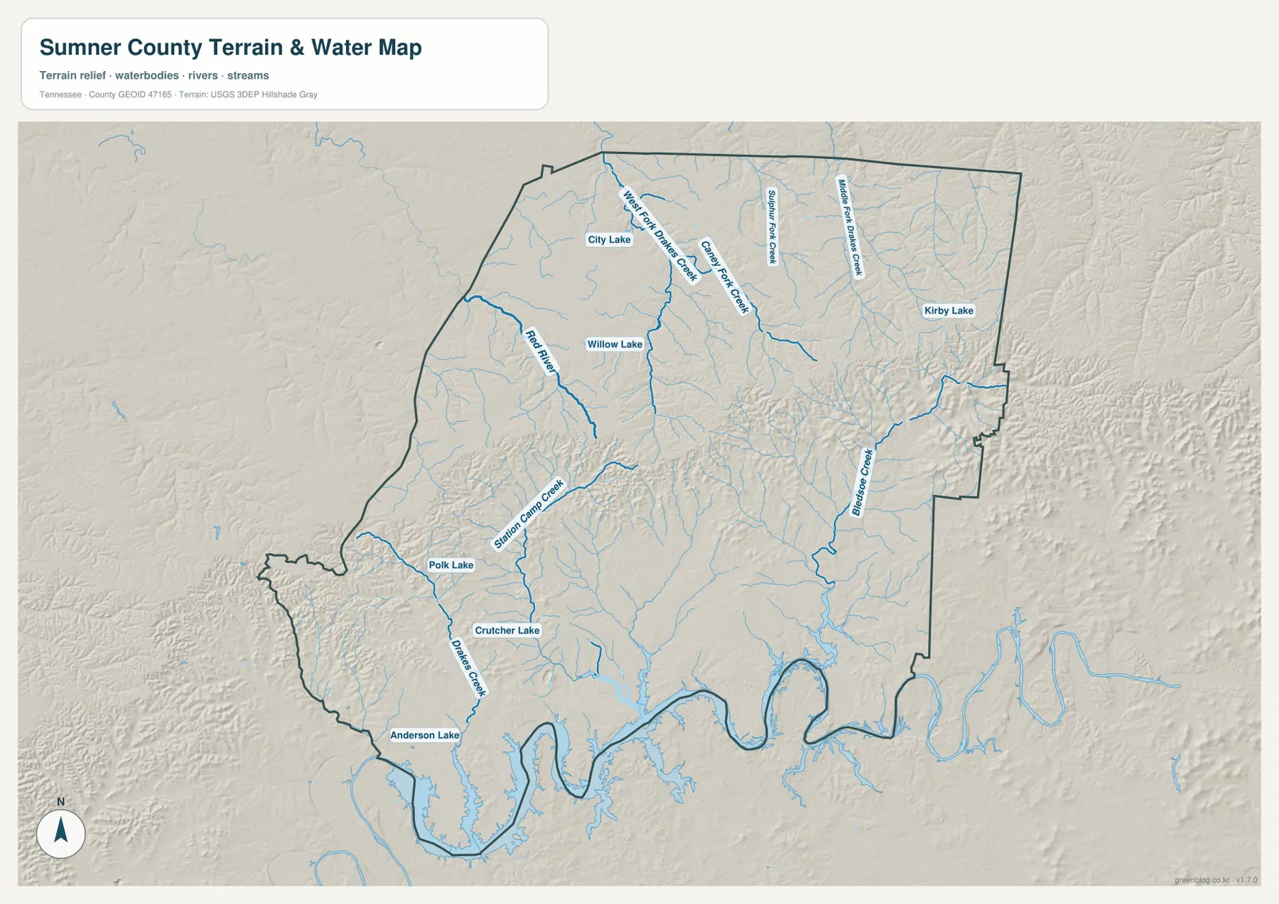
The relationship between water and settlement is especially visible in the south. Hendersonville sits immediately beside the reservoir, while Gallatin lies inland from several creek and lake arms. Portland and Westmoreland are farther from the main reservoir but are crossed or surrounded by many smaller drainages. Sumner County therefore has both a major southern lake landscape and a dense network of smaller streams farther north.
Elevation rises from the southern lake country into the higher north
The elevation map shows an actual mapped range of about 91 to 327 meters, with a mean near 212 meters. Lower green terrain is widespread along the southern part of the county, including the Old Hickory Lake edge and much of the Hendersonville–Gallatin area. Northward, yellow, tan, and brown tones become more common as the landscape rises into a series of ridges cut by narrow valleys.
The strongest high-relief pattern appears across the northern and northeastern sections. Portland and Westmoreland occupy terrain that is generally higher than the lake-side south, and many streams follow green corridors between the ridges. When the elevation map is compared with the water map, the branching form of Drakes Creek and Bledsoe Creek makes more sense: the channels use lower valleys that thread through the higher ground.
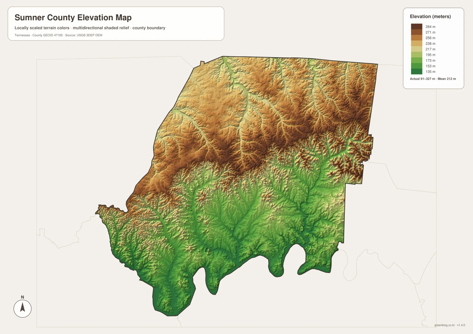
This elevation layer is intended for county-scale comparison. It is useful for seeing broad differences between the low south and the more rugged north, but it should not be used as a parcel survey, engineering surface, or exact property elevation source. More detailed elevation data would be needed for those purposes.
Roads connect the urban south with higher and more separated northern towns
The road network changes character as it moves away from the southern urban area. On the west side, 31W and 41 provide the White House–Portland direction. Route 109 links the Gallatin area with the northwest, while 31E and 6 serve the east and northeast. Route 52 crosses the northern tier near Westmoreland, and 231 provides another north-south reference on the eastern side.
This arrangement matters because Portland and Westmoreland are not simply extensions of the Hendersonville–Gallatin built-up area. They are separated by larger stretches of rolling and dissected terrain, and the roads must cross or follow numerous stream valleys. In the south, routes pass through lower terrain and around the irregular arms of Old Hickory Lake. The county map becomes much more informative when those road lines are interpreted with the water and elevation maps beside it.
The static map is not a turn-by-turn navigation product and does not show every local street, interchange, bridge condition, or temporary closure. Its strength is showing the larger county relationship: where the main communities sit, which numbered routes connect them, and how the route pattern changes between the low southern lake country and the higher north.
A historic county seat within a modern multi-city county
The supplied references state that Sumner County was established in 1786 and that Gallatin is the county seat. The city map, however, ranks Hendersonville as the largest labeled city. This is a useful county-specific distinction rather than a contradiction: administrative importance and city population are different measures. A reader looking for county government should begin with Gallatin, while someone studying the largest urban area or lake-side development should give Hendersonville equal attention.
The shape of the county reinforces that multi-center character. The southern edge is deeply indented by reservoir arms, the north reaches the Kentucky line, Portland sits apart in the northwest, and Westmoreland is separated in the northeast. Focusing on Gallatin alone would miss much of the county’s geographic spread and the different landscapes associated with those outer communities.
Using the 2020 population and the listed land area gives a simple average of roughly 370.7 people per square mile. That number is helpful for comparing county scale, but it should not be treated as a map of neighborhood density. The visible city pattern, road network, streams, and terrain show that development is much more concentrated in some parts of Sumner County than in others.
Which Sumner County map is most useful for your task?
Start with the county map when you need communities, roads, boundaries, and the southern water edge in one view. The city map is faster for comparing Hendersonville, Gallatin, Goodlettsville, Portland, Millersville, and Westmoreland. Use the water map when the main question involves Old Hickory Lake, Drakes Creek, Station Camp Creek, Red River, or Bledsoe Creek. The elevation map is best for explaining why the northern half appears more broken into ridges and valleys than the south.
For printed study sheets, it is often clearer to separate themes. A transportation copy might mark Gallatin, Hendersonville, Portland, 31W, 31E, and 109. A physical-geography copy could emphasize Old Hickory Lake, Drakes Creek, Bledsoe Creek, and the higher northern ridges. Keeping the annotations focused makes the A3 originals easier to read than trying to place every possible note on the same map.
Frequently Asked Questions
Is Gallatin or Hendersonville the county seat?
Gallatin is the county seat. Hendersonville is ranked as the largest city on the supplied city map, but city size and county-government status are different measures. Gallatin is the better reference for administrative orientation, while Hendersonville is central to understanding the southwest urban area and the Old Hickory Lake shoreline.
What is the large waterbody along southern Sumner County?
The supplied county material identifies it as Old Hickory Lake. Its shoreline forms deep arms along the southern edge of the county, especially near Hendersonville and south of Gallatin. Several interior streams, including Station Camp Creek and Drakes Creek, lead toward this lower southern water system.
Why does the elevation map look much browner in the north?
The northern and northeastern parts of Sumner County are generally higher than the southern lake area. The mapped elevation range is about 91 to 327 meters, with a mean near 212 meters. Closely spaced ridges and stream valleys create the stronger brown-and-green contrast visible across the northern half.
Map File Information
The ZIP contains high-resolution JPG versions of the Sumner County map, city map, water map, and elevation map used in this article. All four originals use an A3-format layout and are better suited to printing or enlarged viewing than the WebP previews in the page body.
- Included Files: County map, city map, water map, and elevation map
- File Type: ZIP containing 4 JPG images
Related Maps
- Alamo to Gadsden: A Crockett County Tennessee Map
- Altamont, Monteagle, and Plateau Valleys — Grundy County Tennessee Map
- Around Chattanooga: Hamilton County Tennessee Map
Sources and References
- Tennessee State Library and Archives Sumner County fact sheet
- Tennessee Department of Transportation Sumner County map
- U.S. Census Bureau Sumner County QuickFacts
- USGS National Hydrography
- USGS 3D Elevation Program
Green Map creates custom-edited map images using open geographic data sources such as geoBoundaries, Natural Earth, OpenStreetMap, and government open data. These maps are edited visual materials, not raw data files, and are provided for education, documents, presentations, and graphic reference.