Bradford County, Florida becomes much easier to understand once Starke is used as the main reference point. The county seat sits toward the eastern side, Lawtey is north along the US 301 corridor, Hampton is south, and Brooker lies well to the west. Roads converge around Starke, while lakes, creeks, and the Santa Fe River give the southern and western portions a very different geographic character. This page explains the county map, city-connections map, and terrain-and-water map supplied in the current package, and the matching high-resolution JPG files are available together in the download box below.
Bradford County is a compact inland county in Northeast Florida rather than a single continuous urban area. The existing county material lists a July 1, 2025 population estimate of 28,307 and a 2020 land area of 293.96 square miles, with Starke serving as the county seat. Lawtey, Hampton, and Brooker are separated from Starke by rural land, waterways, and smaller roads, so one map cannot emphasize every useful feature equally. Reading the settlement pattern first and then switching to the water map gives a clearer picture of how transportation and natural features divide the county.
Table of Contents
Starke as the Road Reference Point
The county map puts Starke near the eastern side of Bradford County, where several of the most visible roads meet. US 301 runs north through Lawtey and passes Starke before continuing south, making it the clearest north-south route on the map. State Road 100 leaves the Starke area toward the east and southeast, while SR 16, SR 18, SR 230, and the US 200 corridor provide additional directions across the county and into neighboring areas. Rather than treating those roads as a route-planning network, the map is best used to see how the towns are positioned around the Starke road junction.
Labels outside the county line help establish the broader setting. Lake Butler appears to the west, Waldo to the south, Gainesville farther southwest, and Keystone Heights beyond the eastern side. The companion city map names Baker County to the north, Clay County to the east, Putnam County to the southeast, and Union and Alachua Counties along the western and southwestern sides. Together, those labels show that Bradford County is inland and that its administrative center is noticeably closer to the eastern boundary than to the far western edge.
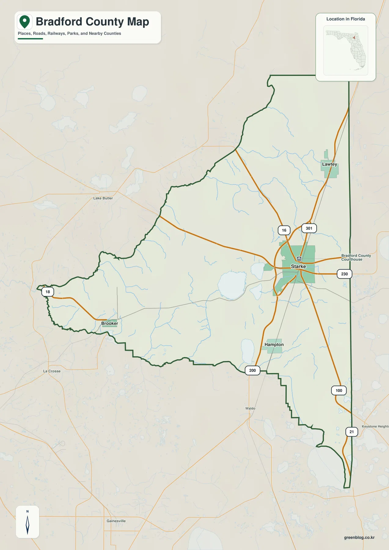
This is an orientation map, not a turn-by-turn navigation product. It works well for comparing where Lawtey sits along US 301 north of Starke, how Hampton is separated to the south, and why Brooker feels more connected to the western side of the county. The broad spaces between those labels are also meaningful. They show how quickly the map moves away from the concentrated Starke road network into rural areas crossed by smaller roads and waterways.
Four Municipalities Spaced Around Starke
The city-connections map simplifies the county to four named municipalities and uses Starke as the hub. Its index displays Starke with a value of 5,877, Lawtey with 897, Hampton with 499, and Brooker with 223. Those figures should be treated as values printed on this specific map rather than as a replacement for a current Census release. The useful geographic message is that Starke is visually dominant while the other municipalities are smaller and lie in different parts of the county instead of forming one compact cluster.
The map also gives direct distances from Starke: about 8 miles to Lawtey, 6 miles to Hampton, and 14 miles to Brooker. These are straight-line distances, not driving mileage or travel-time estimates. Lawtey follows the same general US 301 corridor north of Starke, while Hampton sits south on a separate local route. Brooker is farther west and is shown much closer to the Union County and Alachua County sides of the map, which explains why its 14-mile separation from the hub is the largest of the three connections.
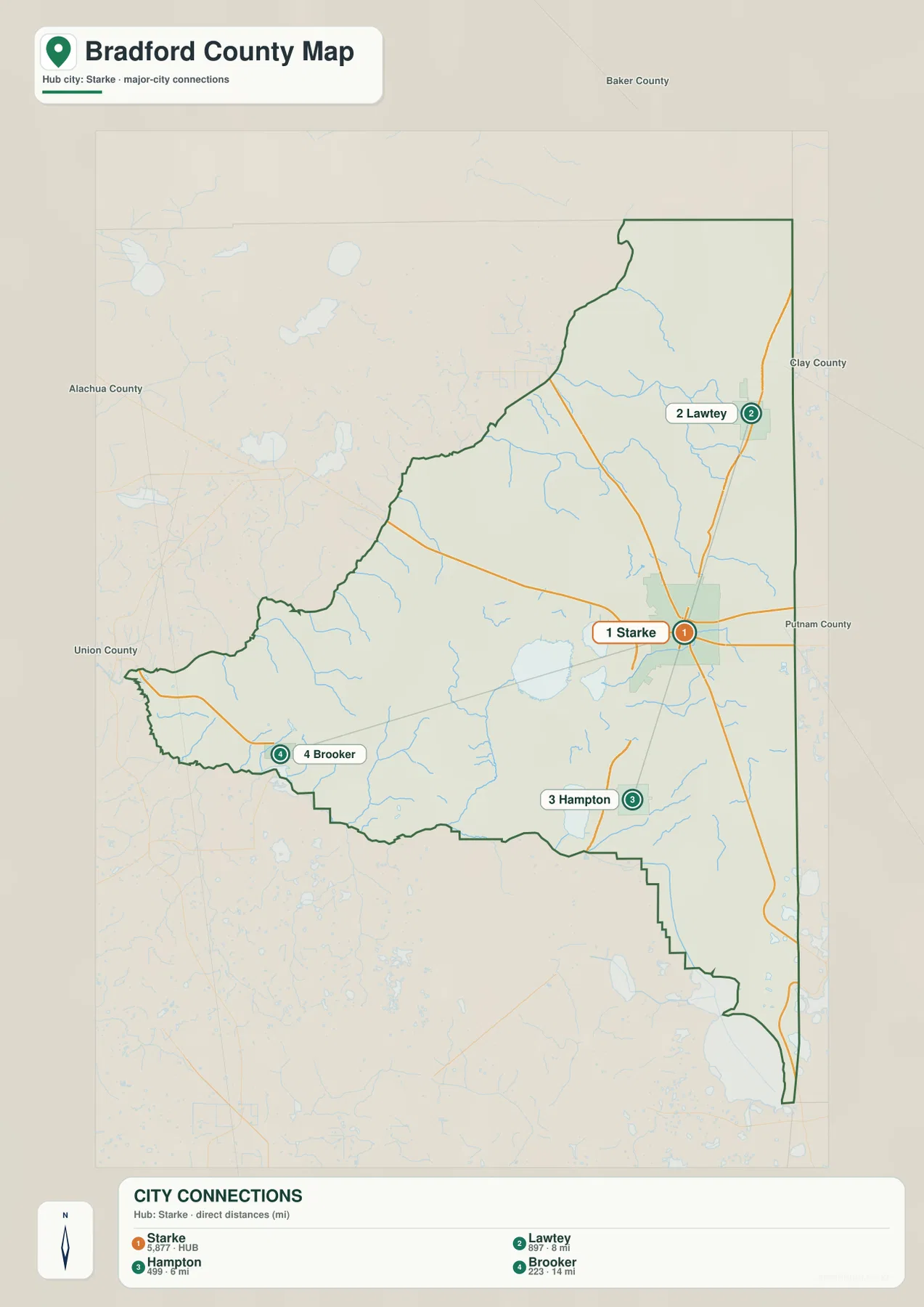
The surrounding county names add another layer that the four-city comparison alone cannot provide. Baker County is north of the county frame, Clay County is east, Putnam County is southeast, and Union and Alachua Counties lie to the west and southwest. That setting helps explain why each municipality faces a different side of Bradford County. Starke may be the shared administrative center, but the county is not arranged like a circular metro area with every town equally close to the same edge or highway.
Lake Sampson, Creeks, and the Santa Fe River
The terrain-and-water map shifts attention away from roads and toward the county’s lakes and drainage network. Lake Sampson and Lake Crosby are labeled west and southwest of Starke, while Hampton Lake appears farther south. Sampson River leaves the Lake Sampson area and runs toward the southern county edge, giving the viewer a clear connection between a named lake and a larger downstream channel. Near the southeastern side, the Santa Fe River follows part of the broader county-boundary area and provides one of the strongest water references on the map.
Smaller streams fill in the northern and eastern interior. Gum Creek, Water Oak Creek, and Alligator Creek are among the clearly labeled names, and many thinner tributaries branch across the county around them. The wider map background also labels water bodies such as Granny Bay, Center Bay, Pine Bay, and Five Mile Bay outside or near the county frame. Those surrounding labels are useful for context, but the dark Bradford County boundary should always be checked before assuming that every named water feature lies inside the county.
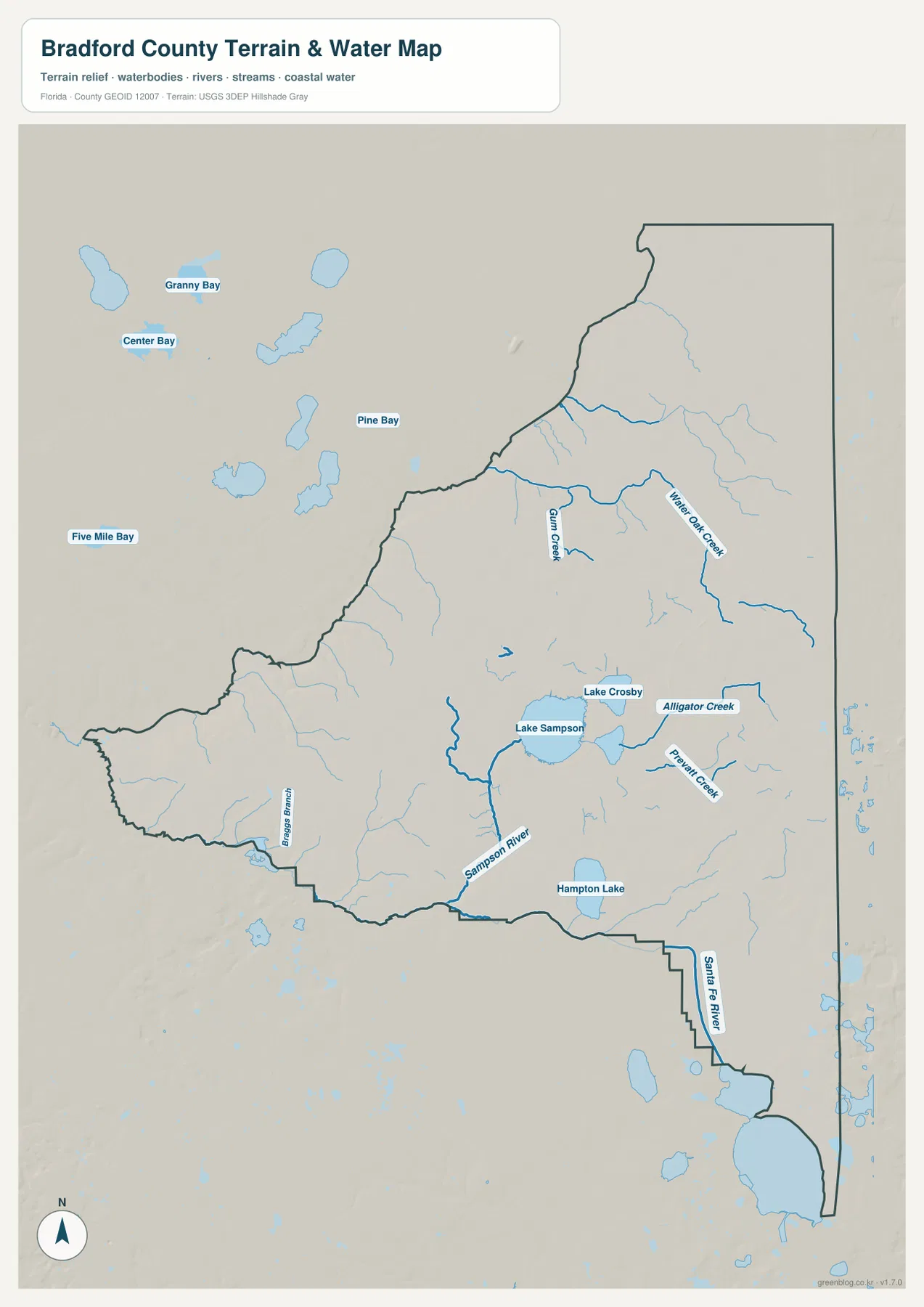
This water image is a geographic reference map rather than a flood-zone, parcel, depth, or navigation map. It includes shaded terrain in the background, but the current package does not contain a separate elevation map, so the shading should not be used to assign a precise height to any location. Its value is in showing where the larger lakes and streams sit relative to Starke and the county boundary. For flood regulation, property limits, or current hydrologic conditions, an official agency product should be consulted instead.
A Western Boundary Shaped by Union County History
Bradford County’s present outline makes more sense when its county history is kept in view. The county government traces the jurisdiction to New River County, created in 1858 from parts of Columbia and Alachua Counties and renamed Bradford County in 1861. Lake Butler served as an early county seat, but Starke gained importance as transportation and commercial activity developed. After a series of county-seat changes and disputes, Starke became the permanent seat in 1887, which helps explain why modern government functions remain concentrated on the eastern side of the map.
The major change on the western side came in 1921, when Lake Butler and the western portion of Bradford County were separated to create Union County. On today’s county map, Lake Butler is outside the Bradford County boundary to the west, so the two places can look like ordinary neighboring jurisdictions with no deeper connection. Knowing the boundary history explains why the county’s current shape is narrower than its earlier jurisdiction and why Brooker sits close to a county line that did not always divide the same communities.
That history also reinforces what the modern maps show about Starke. The county seat lies where the strongest visible roads meet, while the western side stretches toward Union County through more rural territory. South and southwest of the Starke area, lakes and Santa Fe watershed features become increasingly important reference points. The result is a county where the administrative and transportation center is concentrated in one area even though the physical geography extends in several different directions.
Choose the Map by the Question You Need to Answer
Use the county map first when the goal is general orientation. It shows the Bradford County boundary, the main roads around Starke, and the relative positions of Lawtey, Hampton, Brooker, and nearby places outside the county. The city-connections map is better when the comparison is specifically between the four municipalities because it isolates the Starke hub and gives direct distances to the other three. For lakes, creeks, and river locations, the terrain-and-water map provides much more detail than the road-focused image.
The WebP images in the article are intended for comfortable on-screen viewing, while the download archive contains the matching high-resolution JPG files. The ZIP includes three separate JPGs for the county, city, and water maps, so each can be used independently rather than captured from the webpage. The archive filename includes both Bradford County and Florida, which helps keep it distinct from counties of the same name in other states. It is the more practical choice for printing, classroom material, presentations, or any project that needs a larger original image.
Frequently Asked Questions
Why is Starke the best starting point for reading the Bradford County maps?
Starke is the county seat and the clearest road junction in the supplied county map. US 301 runs through the Starke area toward Lawtey, while several other routes branch east, west, and south. The city-connections map also treats Starke as the hub, so using the same starting point makes it easy to compare all three map types without changing orientation.
Are the 6-, 8-, and 14-mile figures on the city map driving distances?
No. The city map identifies them as direct distances from Starke, so they should be read as straight-line comparisons rather than road mileage. The map shows Hampton at about 6 miles, Lawtey at about 8 miles, and Brooker at about 14 miles from the hub. Actual driving distance depends on the road used and the exact starting and ending points.
Which water features are easiest to locate on the Bradford County water map?
Lake Sampson and Lake Crosby are strong reference points west and southwest of Starke, and Hampton Lake is labeled farther south. Sampson River extends south from the Lake Sampson area, while the Santa Fe River is visible near the southeastern boundary. Gum Creek, Water Oak Creek, and Alligator Creek add smaller stream references across the northern and eastern interior.
Sources and Reference Material
- Bradford County, Florida — About Us — county seat, county formation, and Union County history
- U.S. Census Bureau QuickFacts — Bradford County, Florida — population, land area, and density reference
- Florida Department of Transportation — Official Transportation Map — US 301 and state-road context
- Suwannee River Water Management District — Santa Fe River watershed and regional water information
Map File Information
This ZIP contains high-resolution JPG versions of the Bradford County, Florida county map, city map, and water map shown on this page.
- File Type: ZIP containing 3 JPG files
Related Maps
Green Map creates custom-edited map images using open geographic data sources such as geoBoundaries, Natural Earth, OpenStreetMap, and government open data. These maps are edited visual materials, not raw data files, and are provided for education, documents, presentations, and graphic reference.