Oakland County sits immediately north of Detroit and combines one of Michigan’s most continuous suburban landscapes with a surprisingly lake-rich interior. Pontiac provides a useful central reference, while Troy, Southfield, Farmington Hills, Novi, Rochester Hills, and other communities form a dense southern and eastern belt. Farther north and west, city labels thin out and the map fills with lakes, streams, and rolling uplands. The downloadable package on this page includes the same four A3-resolution JPG maps used below, collected in one ZIP file.
The county is easiest to understand as a transition rather than a single uniform landscape. Interstate and state highway corridors knit together the developed southeast, yet the northern half looks distinctly different, with wider spaces between major roads and a much denser pattern of small water bodies. The water map shows several river systems beginning or passing through the county, while the elevation map reveals higher ground toward the north and west. Reading those layers together explains why Oakland County can feel intensely urban in one direction and much more like inland lake country in another.
Table of Contents
Pontiac anchors a dense southeast cluster that reaches Troy, Royal Oak, and Southfield
On the general county map, the greatest concentration of place names lies in the southeast. Pontiac appears near the center-east, with Auburn Hills and Rochester Hills immediately to the east and northeast. Troy, Birmingham, Royal Oak, Madison Heights, Oak Park, and Southfield form a closely spaced group farther south. Farmington Hills and Novi extend the developed belt toward the southwest, while Wixom sits near the western edge. This pattern gives the southern half of the county a very different visual character from the more open north.
Pontiac is especially useful for orientation because several major roads converge around it and the county courthouse complex is labeled nearby. From Pontiac, Troy is to the southeast, Rochester Hills to the east, and the Farmington Hills–Novi area to the southwest. The map also shows how quickly the built-up area approaches the Wayne County line toward Detroit. By contrast, north of the Pontiac and Rochester Hills zone, road spacing increases and lakes become more prominent than large city labels.
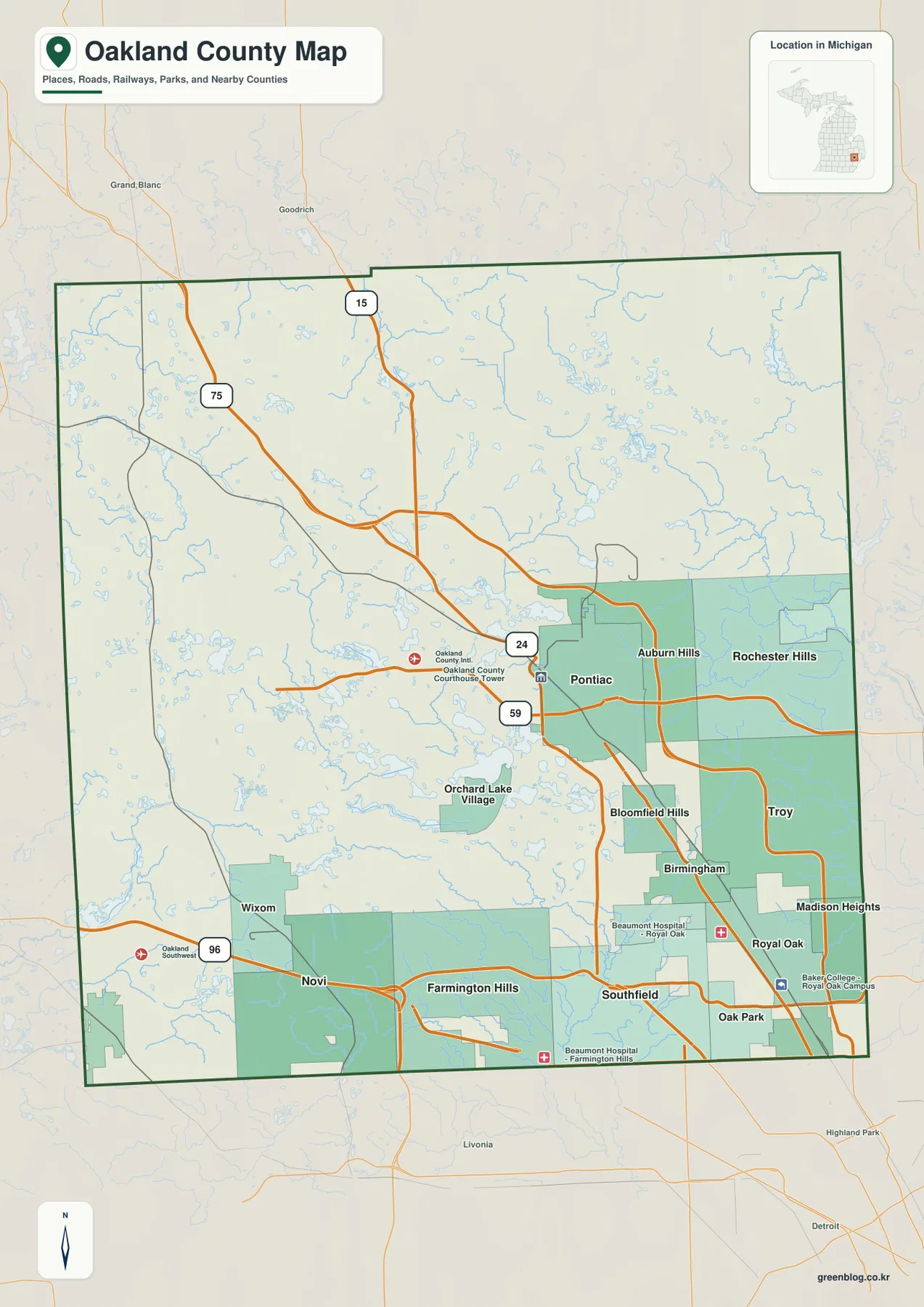
This map works best as a broad orientation sheet rather than a turn-by-turn road map. It gives enough highway detail to relate the main cities to one another, and it keeps the many lakes visible so the western and northern parts do not disappear behind the urban story. Neighboring areas, including Detroit to the south, remain visible outside the county boundary for context. The boundary shown here is appropriate for general reference, but parcel ownership, legal boundary questions, and surveying should be checked against the responsible local or state records.
I-75, I-96, M-59, and US-24 provide a simple framework for the road network
Oakland County contains many arterial roads, but four large routes make the overall pattern easier to follow. I-75 descends from the northwest toward Auburn Hills and Troy before continuing south. I-96 crosses the southwest near Novi and Wixom. M-59 runs across the Pontiac area and continues eastward, while US-24 provides a strong north-south reference near Pontiac and the southern suburbs. Locating these routes first makes the rest of the road network much less intimidating.
The highway pattern also helps explain the separation between the county’s major urban centers. Auburn Hills and Troy are closely associated with the I-75 corridor, Novi is tied to the I-96 side of the county, and Pontiac occupies the middle of several connecting routes. Southfield and Farmington Hills sit in the southern tier where east-west and north-south movement overlap. The map is useful for these relationships, but it does not show current congestion, closures, construction, or every local street needed for a trip.
In the north and west, the practical geography changes. A straight line between two places may cross lakes or follow terrain that forces local roads to bend. That is why the map can make short distances look simpler than actual driving. For travel planning, use the county map to establish direction and then check a current navigation or transportation source for the final route. For classroom or presentation use, the general map is especially good at showing how transportation corridors and water features share the same landscape.
The city index makes the south-and-east concentration immediately visible
The city index highlights six major cities: Troy, Farmington Hills, Rochester Hills, Southfield, Novi, and Pontiac. Their placement tells the story more clearly than a long list of municipalities. Troy and Rochester Hills occupy the eastern side, Southfield and Farmington Hills sit along the southern tier, Novi extends the group westward, and Pontiac is farther north near the middle-east. None of the six is located in the far northern portion of the county.
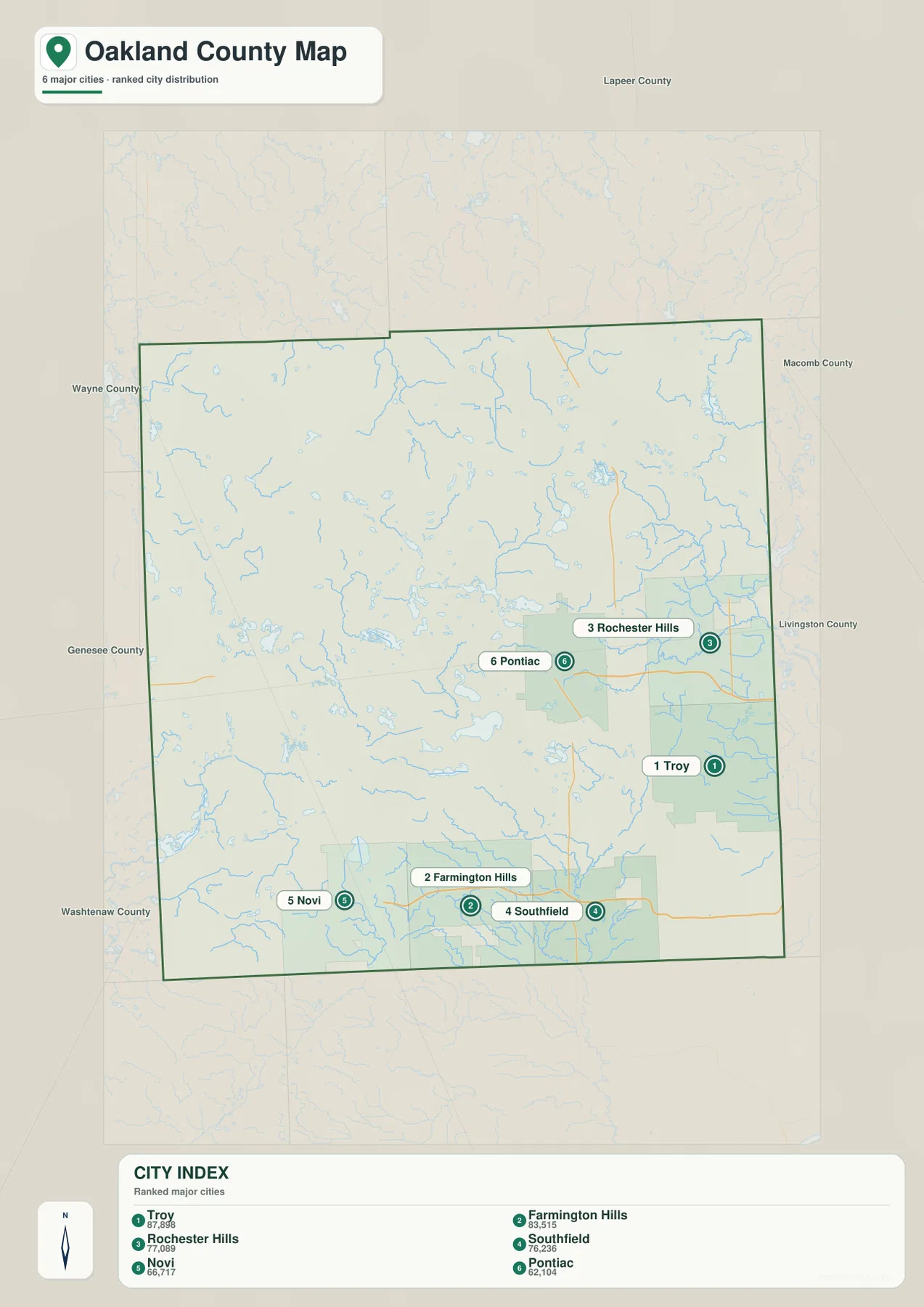
Because the index suppresses many smaller labels, it is useful when the purpose is simply to compare major population centers. It makes the gap between the urban south and the lake-filled north easier to see, and it keeps viewers from getting lost in the dense street pattern around Detroit’s northern suburbs. The tradeoff is that it cannot explain how the cities connect by highway or how smaller communities fit between them. For that, the general county map provides the needed context.
The two maps also prevent a common misunderstanding: a ranked city list is not the same thing as a map of the entire settlement system. Birmingham, Royal Oak, Madison Heights, Bloomfield Hills, Auburn Hills, and other places matter to the county’s geography even though they are not part of this six-city index. Use the index for a clean comparison, then return to the general map when you need the fuller network of communities, roads, and surrounding water features.
Oakland County is a headwaters landscape with lakes feeding several river systems
The terrain-and-water map shows that the county does not drain through one dominant river. The Shiawassee River appears in the west, the Huron River system occupies the southwest, and the South Branch Flint River is visible toward the north. Paint Creek and the Clinton River cross the east, while branches of the Rouge River spread through the southeast. These waterways leave the county in different directions, which is why the map feels more like a dividing ground between watersheds than a single river valley.
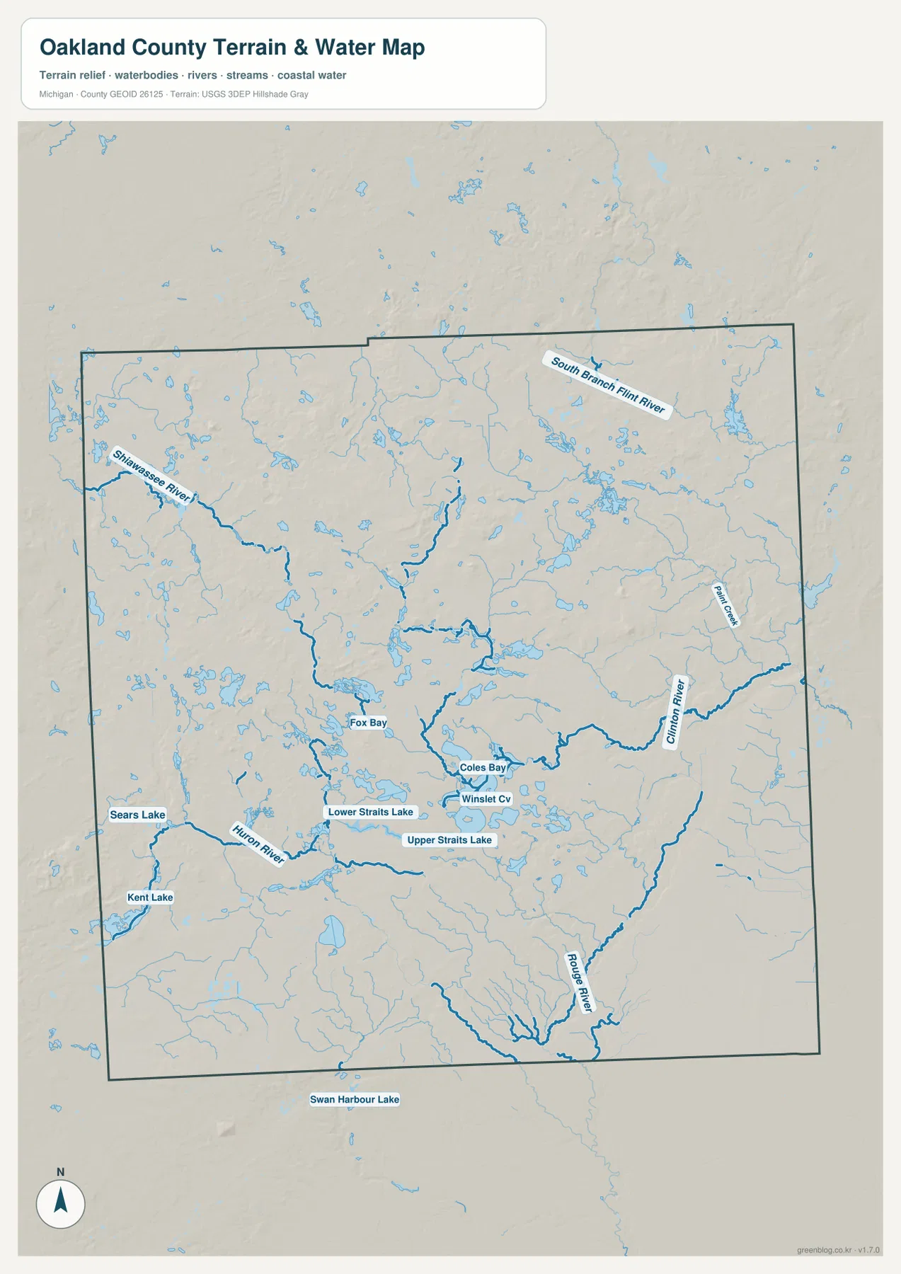
The lake pattern is just as important as the named rivers. Kent Lake is visible in the southwest, while Sears Lake, Upper Straits Lake, Lower Straits Lake, and many smaller water bodies appear across the interior. Some areas contain clusters of small lakes separated by short stream segments, especially away from the dense southeast. Oakland County’s official description likewise emphasizes the large number of lakes, rivers, and streams and the presence of multiple river headwaters, matching what is visible on this map.
This is a reference map for water location and terrain context, not a flood, navigation, depth, or water-quality product. A river line can tell you where the Clinton or Rouge system runs, but it cannot determine whether a particular property is in a floodplain or whether a lake is open to a certain kind of boating. Those questions require current information from the appropriate agencies. For geographic education, however, the map is well suited to showing how closely lakes and streams are woven into Oakland County’s suburban and rural areas.
Higher northern and western uplands descend toward the lower southeast
The elevation map adds a contrast that is easy to miss on the road map. Browns and deeper tan colors cover much of the north and northwest, indicating higher and more irregular terrain. The center becomes somewhat more moderate, and green shades expand toward the southeast. The lower terrain therefore overlaps broadly with the county’s densest urban belt, while the higher ground coincides with much of the lake-rich northern and western interior.
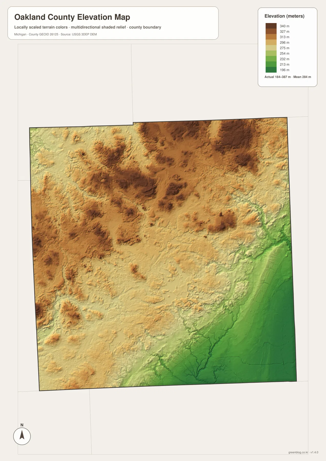
The legend uses a color range from roughly 196 to 340 meters, while the map notes that the actual minimum and maximum extend somewhat beyond those class breaks. The most useful information is not a single value but the broad gradient. Northern and western terrain has repeated ridges and depressions, while the southeast appears lower and smoother. That pattern provides a physical backdrop for the distribution of lakes and helps distinguish the county’s upland interior from its heavily developed edge near Detroit.
This elevation surface is generalized for county-scale comparison. It should not be treated as a survey, an engineering-grade ground model, or a source for exact building-site elevations. Drainage design, construction, flood decisions, and property-level work require more detailed data and professional methods. For a report or classroom explanation, the map is useful precisely because it simplifies the county’s relief into an understandable regional pattern.
Parks and trails connect the urban edge with the lake country
Oakland County’s official parks information reflects the same geographic range shown on the maps. Park and trail sites occur near developed communities as well as in the more open north and east, where lakes and rolling terrain are more prominent. Addison Oaks, for example, is located in the northeastern part of the county and offers a setting that fits the higher, lake-rich landscape seen on the water and elevation maps. Other recreation areas lie closer to Pontiac, Waterford, and the southern suburbs.
For a park visit, the four maps can be used in sequence. Start with the general map to understand the nearest city and highway, check the water map when the destination is near a lake or stream, and use the elevation map for a rough sense of surrounding relief. The city index is useful when the trip begins in one of the larger suburban centers. Opening hours, trail conditions, parking rules, reservations, and activity restrictions are not contained in these images, so current Oakland County Parks information should be consulted before visiting.
Choose the map that matches the question instead of forcing every detail onto one sheet
For an overview of communities and transportation, the general county map is the strongest choice. It combines Pontiac, Troy, Southfield, Novi, Rochester Hills, and many smaller places with I-75, I-96, M-59, US-24, the county boundary, and visible water features. If the goal is only to show where the largest highlighted cities are concentrated, the city index is cleaner and easier to read at a distance.
For environmental or physical geography, the water and elevation maps carry more useful detail. The water sheet separates the Shiawassee, Huron, Clinton, Rouge, and Flint-related drainage patterns and preserves the county’s many small lakes. The elevation sheet reveals the higher northern and western uplands and the lower southeast. Used together, they show why Oakland County cannot be described accurately as either purely urban suburbia or purely lake country; both landscapes are present within the same boundary.
The downloadable archive contains the original JPG versions of the county, city-index, water, and elevation maps shown in this article. Each file is 2572 × 3638 pixels, suitable for A3 portrait-oriented printing and for use in lessons, regional overviews, presentations, or personal reference. Check legibility after scaling for smaller paper sizes. These maps are not substitutes for legal surveys, emergency mapping, flood determinations, or engineering data.
Frequently Asked Questions
Which map is best for comparing Pontiac, Troy, Novi, and Southfield?
Use the general county map when you also need highways and surrounding communities. Pontiac lies farther north, Troy is southeast of it, Southfield is in the southern tier, and Novi is toward the southwest. If you only need a clean comparison of the six highlighted major cities, the city index is easier to read. Neither map should be used as a substitute for current routing information when estimating travel time.
Where can I see Oakland County’s many lakes and different river systems?
The terrain-and-water map is the best choice. It shows the Shiawassee and Huron systems toward the west, the South Branch Flint River in the north, Paint Creek and the Clinton River in the east, and Rouge River branches in the southeast. Kent Lake and several named inland lakes are also visible. The map explains water geography but does not provide flood zones, water depth, navigation rules, or water-quality conditions.
What is the main relief pattern on the Oakland County elevation map?
The north and northwest are generally higher and more irregular, while the southeast is lower and smoother. Brown and tan colors dominate the uplands, with greener shades increasing toward the Troy, Southfield, and Royal Oak side of the county. The surface is appropriate for county-scale comparison only; exact property elevations, engineering design, and drainage decisions require detailed official data or field surveying.
Map File Information
Download the high-resolution Oakland County JPG maps used on this page in one ZIP file.
- Included Files: county map, city map, water map, elevation map
- File Type: ZIP containing 4 JPG files
Related Maps
Sources and References
- Oakland County – About Oakland County — county overview, communities, parks, lakes, rivers, and streams
- Oakland County Parks & Trails — official park and trail locations and visitor information
- U.S. Census Bureau – TIGER/Line Shapefiles — county boundary and base geography reference
- U.S. Geological Survey – National Hydrography — rivers, streams, and lake reference data
- U.S. Geological Survey – 3D Elevation Program — terrain and elevation reference data
Green Map creates custom-edited map images using open geographic data sources such as geoBoundaries, Natural Earth, OpenStreetMap, and government open data. These maps are edited visual materials, not raw data files, and are provided for education, documents, presentations, and graphic reference.