Huntington County is organized around the city of Huntington, with Roanoke to the northeast, Andrews to the west, Markle near the eastern edge, and Warren in the south. You can download the high-resolution JPG ZIP directly from this page when you need larger road labels, stream names, relief colors, or printable originals. This Huntington County Map page connects the main road network with the Wabash River valley, Salamonie River and reservoir system, Little Wabash River, and a county elevation range of about 154 to 280 meters.
Huntington is the simplest place to use for orientation. State Road 9 runs north-south through the central part of the county, while U.S. 24 heads northeast from the Huntington area toward Roanoke. Andrews lies to the west, Markle is farther east, and Warren is well to the south. Bippus provides another reference in the northwest, so the county reads as one central city surrounded by smaller communities rather than a continuous urban corridor.
The terrain views add a much stronger physical pattern. The Wabash River occupies a broad low corridor across the middle of the county, while higher ground spreads across much of the north. Farther south, the Salamonie River and Salamonie Reservoir/Lake create another low valley system. The elevation legend lists an actual range of about 154 to 280 meters and a mean of 248 meters, making the river valleys easy to distinguish from the surrounding uplands.
Table of Contents
Huntington, U.S. 24, and State Road 9 provide the clearest county orientation
The general county map makes Huntington the most obvious settlement reference. Its developed area is much larger than the other labeled communities, and State Road 9 runs through the central corridor. U.S. 24 leaves the Huntington area toward the northeast, creating a direct visual connection with Roanoke. Parkview Huntington Hospital is labeled just north of the city and provides another clear landmark for the central area.
Roanoke sits in the northeast near the U.S. 24 corridor and State Road 37. State Road 69 forms another north-south reference near the eastern edge. Markle is farther south on that same side of the county, with U.S. 224 extending west toward the Huntington area. Using Roanoke for the northeast and Markle for the east makes the right side of the county much easier to organize.
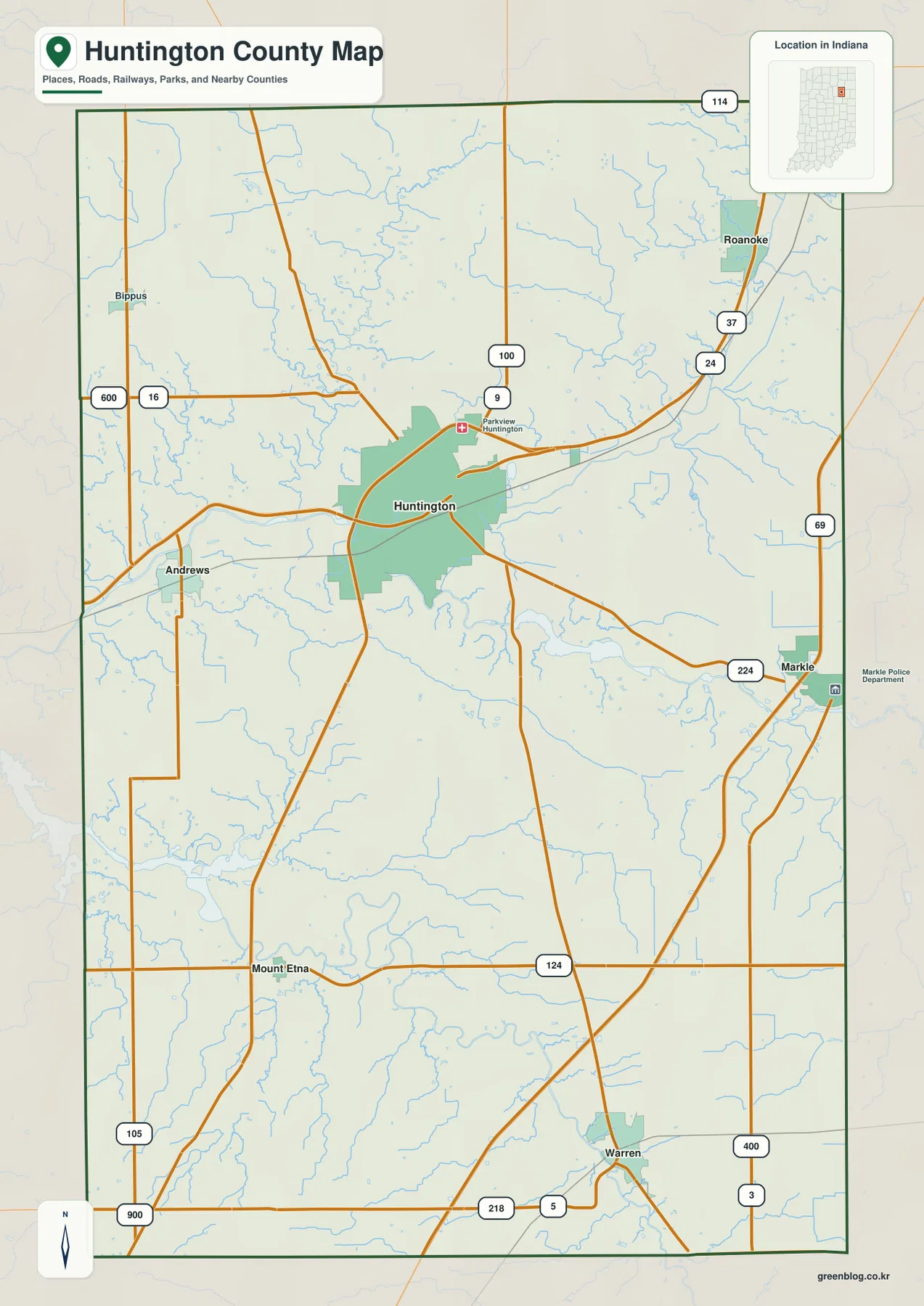
Andrews is the strongest western town reference. Bippus is farther north and is close to the Route 16 corridor, while the western county edge contains several additional numbered roads. Compared with the Huntington and Roanoke side, the west has much larger gaps between settlement labels, so roads and streams become more important for orientation.
The southern half is anchored by Mount Etna and Warren. Mount Etna lies near State Road 124 in the southwest, while Warren is close to the southern edge near State Road 5 and U.S. 218. State Road 3 appears farther east. These references separate the broad southern rural area into manageable sections and make it easier to connect the road map with the Salamonie River system shown on the terrain map.
The city index places Huntington at the center with five smaller communities around the county
The supplied city index highlights six places with values printed on the map. Huntington is shown at 17,030, followed by Roanoke at 1,940, Warren at 1,274, Markle at 1,203, Andrews at 1,038, and Mount Etna at 112. These figures are best treated as the values printed on the supplied map rather than as a guarantee of the newest population estimates. Their main value here is showing the relative scale and wide separation of the highlighted communities.
| Rank | Place | Value printed on map | Position |
|---|---|---|---|
| 1 | Huntington | 17,030 | Central |
| 2 | Roanoke | 1,940 | Northeast |
| 3 | Warren | 1,274 | South |
| 4 | Markle | 1,203 | Eastern edge |
| 5 | Andrews | 1,038 | West |
| 6 | Mount Etna | 112 | Southwest |
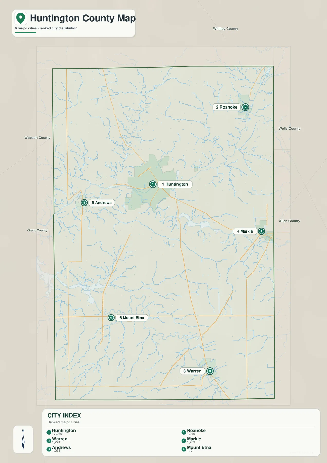
Roanoke and Warren are especially useful for understanding the county’s north-south spread. Roanoke lies well northeast of Huntington, while Warren is near the southern edge. Markle and Andrews provide an east-west contrast, and Mount Etna adds a smaller southwestern reference. The map therefore works as a directional overview as much as a ranking.
The general map contains additional place names such as Bippus, along with more roads and local labels that do not appear in the six-place index. Their absence from the index does not mean those areas are empty. Use the general map for smaller communities and road connections, and use the city index when the relative position and printed values of the six highlighted places are the main question.
Indiana’s official Huntington County profile identifies Huntington as the county seat and lists Roanoke, Warren, Andrews, Markle, and Mt. Etna among the county’s cities and towns. That official context matches the supplied map, where Huntington forms the largest central developed area. The other communities remain important because they define the county’s outer directions and connect the road map to different river and terrain areas.
The Wabash River defines the central lowland while the Salamonie system crosses the south
The terrain-and-water map makes the Wabash River the strongest central feature. It enters from the west and continues across the middle of the county, receiving numerous smaller tributaries. The river is not only a water reference; it also matches the broad low corridor visible on the elevation map. Once Huntington and Andrews are located on the general map, the Wabash helps connect the western and central parts of the county.
North of the Wabash, Clear Creek winds through the north-central area. Little Wabash River appears farther northeast as another long stream. Clair Lake and Big Blue Lake are labeled closer to the east-central part of the county. These smaller features help divide the higher northern terrain into recognizable drainage areas without competing with the Wabash as the main central reference.
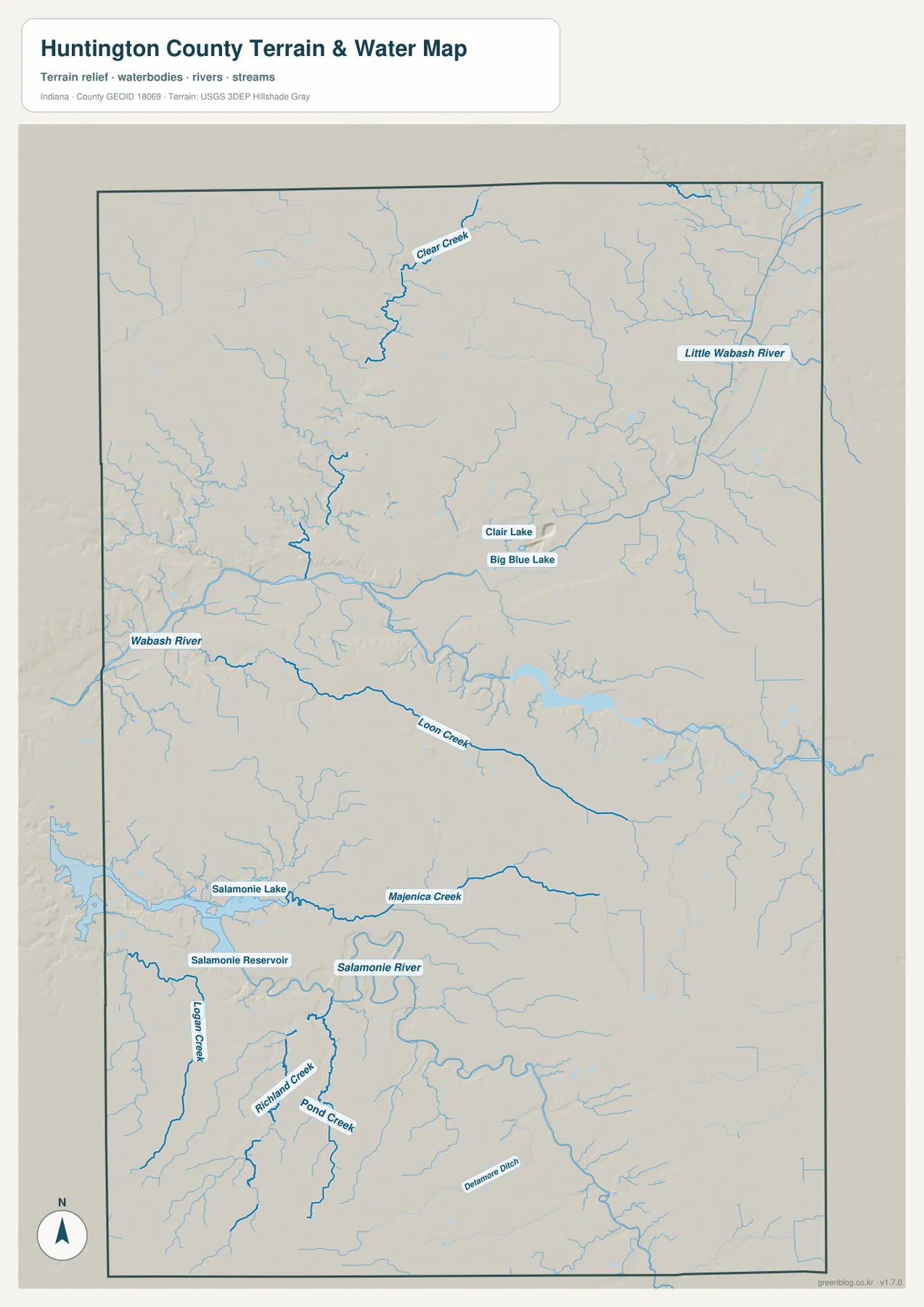
Farther south, Loon Creek runs across the central-southern area, and the Salamonie River becomes the most important water feature below it. Salamonie Reservoir and Salamonie Lake form a broad connected water area in the southwest. Majenica Creek lies just to the north of that system, while Logan Creek, Richland Creek, Pond Creek, and other tributaries divide the southern landscape into smaller valleys.
Indiana DNR’s official Salamonie Lake page describes the lake and surrounding recreation property and notes its flood-control origin. The supplied map places the Salamonie lake/reservoir system and river clearly in the southern part of Huntington County, making the DNR resource a useful companion when readers want local context beyond simple map location.
The water map is intended for geographic reference, not for flood-zone, legal-boundary, navigation, current water-level, or water-quality decisions. A blue line or water polygon does not establish a floodplain or property boundary. Those questions require current agency data. Here, the map is best used to see how the Wabash and Salamonie systems divide the county and where the smaller creeks fit around them.
The 154–280 m elevation map separates broad river valleys from the northern and southeastern uplands
The elevation legend gives an actual county range of about 154 to 280 meters and a mean of 248 meters. Greens mark lower terrain, while yellow, tan, and brown indicate higher ground. The strongest feature is the broad green Wabash River lowland across the middle of the county. It stretches from west to east and curves through the central landscape, creating a sharp contrast with the higher terrain immediately to the north.
The northern half contains extensive brown and tan ground, but it is cut by lower creek valleys. Clear Creek produces one of the most visible north-central cuts, while the Little Wabash system creates a separate low corridor toward the northeast. The relief therefore does not form one flat northern plateau; higher ground is repeatedly divided by green drainage lines.
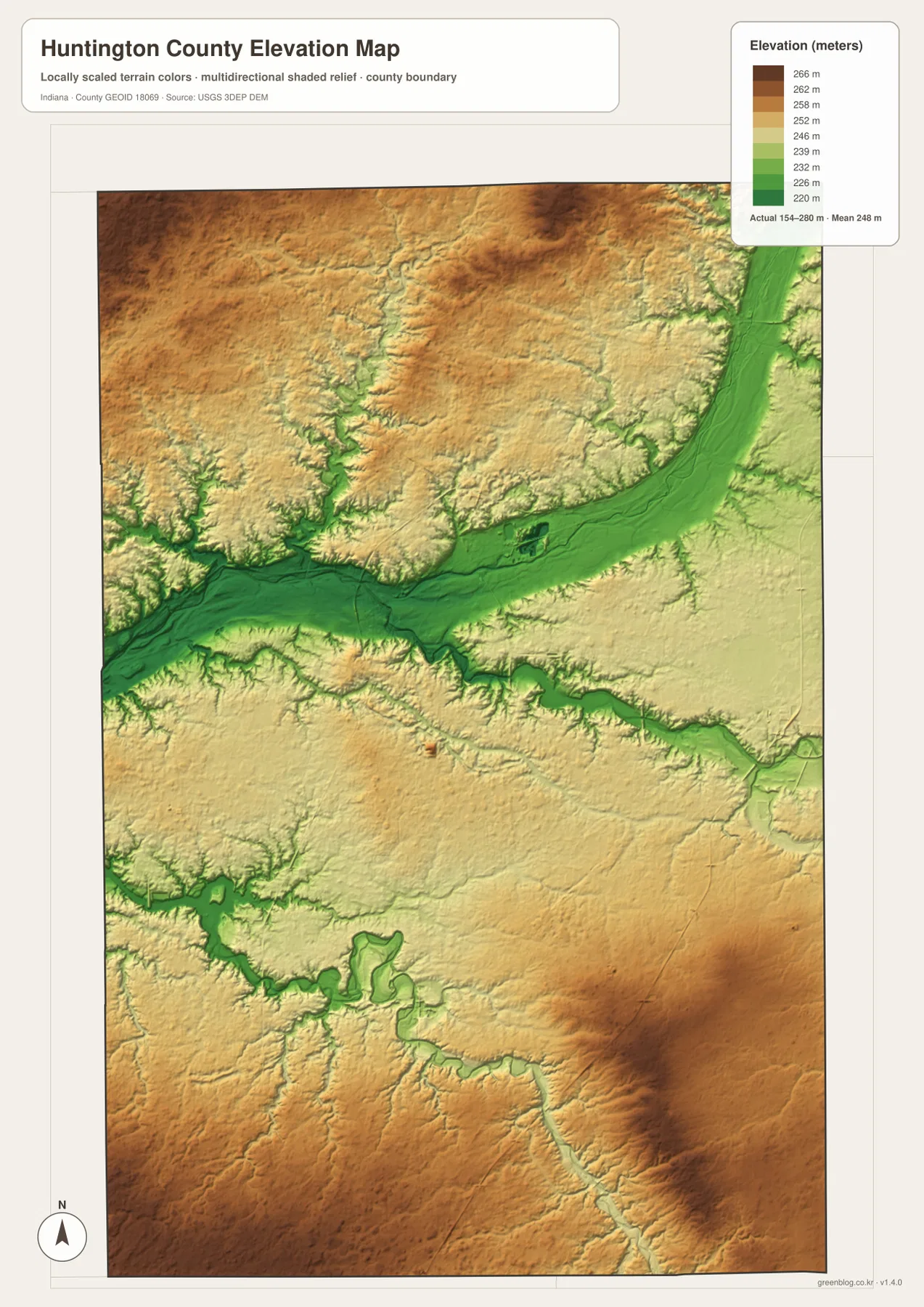
The Salamonie River and reservoir system creates a second major low area in the southern half. Green terrain follows the lake, reservoir, and river, while the land between the Salamonie and Wabash systems rises into lighter yellow and tan ground. This separation makes the two lowland systems easy to distinguish on the relief surface even before the water labels are added.
The southeast contains some of the warmer brown colors on the map, but smaller streams still carve green channels through that high ground. For a simple first reading, it is useful to think of three broad elements: the central Wabash lowland, the southern Salamonie lowland, and the uplands around them. More detailed creek valleys can then be added once those larger forms are familiar.
The 154–280 m range is a county-scale reference, not a survey measurement for a property or engineering project. Building elevations, road grades, drainage design, and parcel-level work require source elevation data or professional surveying. The USGS 3D Elevation Program is a more appropriate starting point for precise terrain information. The supplied image is designed for broad comparison of valleys and surrounding higher ground.
Use the road map for settlements and the terrain maps for the Wabash and Salamonie valleys
For first-time orientation, begin with the general map. Find Huntington and State Road 9, then follow U.S. 24 toward Roanoke, U.S. 224 toward Markle, and the western roads toward Andrews. Warren and Mount Etna provide southern reference points, while Bippus helps identify the northwest. The general map is also the best place to find smaller road numbers and labels.
Use the city index when the main question is how the six highlighted places compare. Huntington dominates the printed values, while Roanoke, Markle, Andrews, Warren, and Mount Etna are widely separated around the county. Current population analysis should use the latest official statistics rather than assuming the map index is current.
For physical geography, locate the Wabash River first, then move south to the Salamonie River and reservoir/lake system and north toward Clear Creek and Little Wabash River. Open the elevation map beside the water map and look for the same channels as green lowlands. That side-by-side comparison makes the central and southern valley systems much easier to understand.
The web previews are optimized for quick page viewing. Small creek labels, road numbers, and fine relief changes are easier to see in the original files. The download archive contains the county/general map, city index map, terrain-and-water map, and elevation map as 2572×3638-pixel JPG originals. Download the ZIP when you want to zoom farther, print the maps, or compare the full-resolution originals side by side.
A useful comparison method is to follow one place through several views. Find Huntington and Andrews on the general map, switch to the water map to locate the Wabash River between and around them, and then check the elevation surface to see the same broad low corridor. In the south, use Warren and Mount Etna as place references before locating the Salamonie system. Repeating the same locations across several maps turns separate images into a clearer picture of Huntington County.
Frequently Asked Questions
What is the easiest way to find Huntington on the map?
Look for the largest developed area near the center of the county and use State Road 9 and U.S. 24 as reference routes. State Road 9 runs north-south through the Huntington area, while U.S. 24 heads northeast toward Roanoke. Parkview Huntington Hospital is also labeled just north of the city.
Where are the Wabash and Salamonie river systems?
The Wabash River crosses the middle of the county from west to east and forms the broadest central lowland. The Salamonie River lies farther south, with Salamonie Reservoir and Salamonie Lake in the southwestern part of the county. Both systems appear as lower green terrain on the elevation map.
Can the 154–280 m elevation range be used as an exact property elevation?
No. The supplied elevation map gives a county-wide range of about 154 to 280 meters, with a mean of 248 meters. It is intended for broad comparison of river valleys and surrounding higher ground. Exact property, construction, drainage, or engineering elevations require source elevation data or professional survey work.
Map File Information
This ZIP contains the Huntington County general map, city index map, terrain-and-water map, and elevation map as high-resolution JPG originals for enlarged viewing and printing.
- File Type: ZIP containing four 2572×3638px JPG files
Related Maps
Sources and References
The article is based primarily on the supplied Huntington County map set and asset manifest. The following official and public sources provide county, recreation, boundary, water, and elevation references.
- IN.gov – Huntington County – official state profile with county-seat and city/town information
- Indiana DNR – Salamonie Lake – official information about Salamonie Lake and its recreation property
- U.S. Census Bureau TIGER/Line Shapefiles – boundary and geographic reference data
- USGS National Hydrography – hydrography reference data
- USGS 3D Elevation Program – elevation source data
Green Map creates custom-edited map images using open geographic data sources such as geoBoundaries, Natural Earth, OpenStreetMap, and government open data.
These maps are edited visual materials, not raw data files, and are provided for education, documents, presentations, and graphic reference.