Greencastle provides an easy starting point for reading Putnam County. US 40 crosses the county from west to east, US 231 runs north to south, and the two routes make the central part of the county easy to orient before looking toward Bainbridge, Roachdale, Russellville, Cloverdale, or Fillmore. The natural landscape is less regular: Big Walnut Creek bends through the central interior, Big Raccoon Creek crosses the northwest, and higher ground is concentrated across parts of the northeast and north-central county. This Putnam County Indiana Map page lets you compare those roads, settlements, waterways, and elevation changes, and you can download the original high-resolution JPG maps in one ZIP from the file box below for printing or close inspection.
The county becomes easier to understand when the four supplied views are used together. The general map keeps the principal highways and named places visible in one frame. The city map strips away much of that detail so the main settlements can be compared more quickly. The water map gives names to the creeks and lakes that are only secondary features on the road view, while the elevation map shows the lower valleys and higher ridges around those waterways. Moving from one view to the next adds detail without changing the underlying geography.
One of the clearest contrasts is between the straight highway network and the irregular creek valleys. US 40 and US 231 create strong directional references around Greencastle, while Big Walnut Creek repeatedly turns as it crosses the central part of the county. On the elevation surface, that creek corridor appears as lower ground, and the hills become more pronounced toward the northeast and north-central interior. Heritage Lake in the east and Van Bibber Lake northwest of Greencastle are also useful landmarks because they are easy to relocate from one map to another.
Table of Contents
US 40 and US 231 make Greencastle easy to locate
On the general county map, Greencastle lies near the middle of Putnam County and close to two of its most recognizable highway lines. US 40 approaches from the west near Putnamville, passes the Greencastle area, and continues east. US 231 runs north–south, connecting the central county with Bainbridge to the north and the Cloverdale area to the south. Finding those two routes first provides a simple frame for the rest of the map.
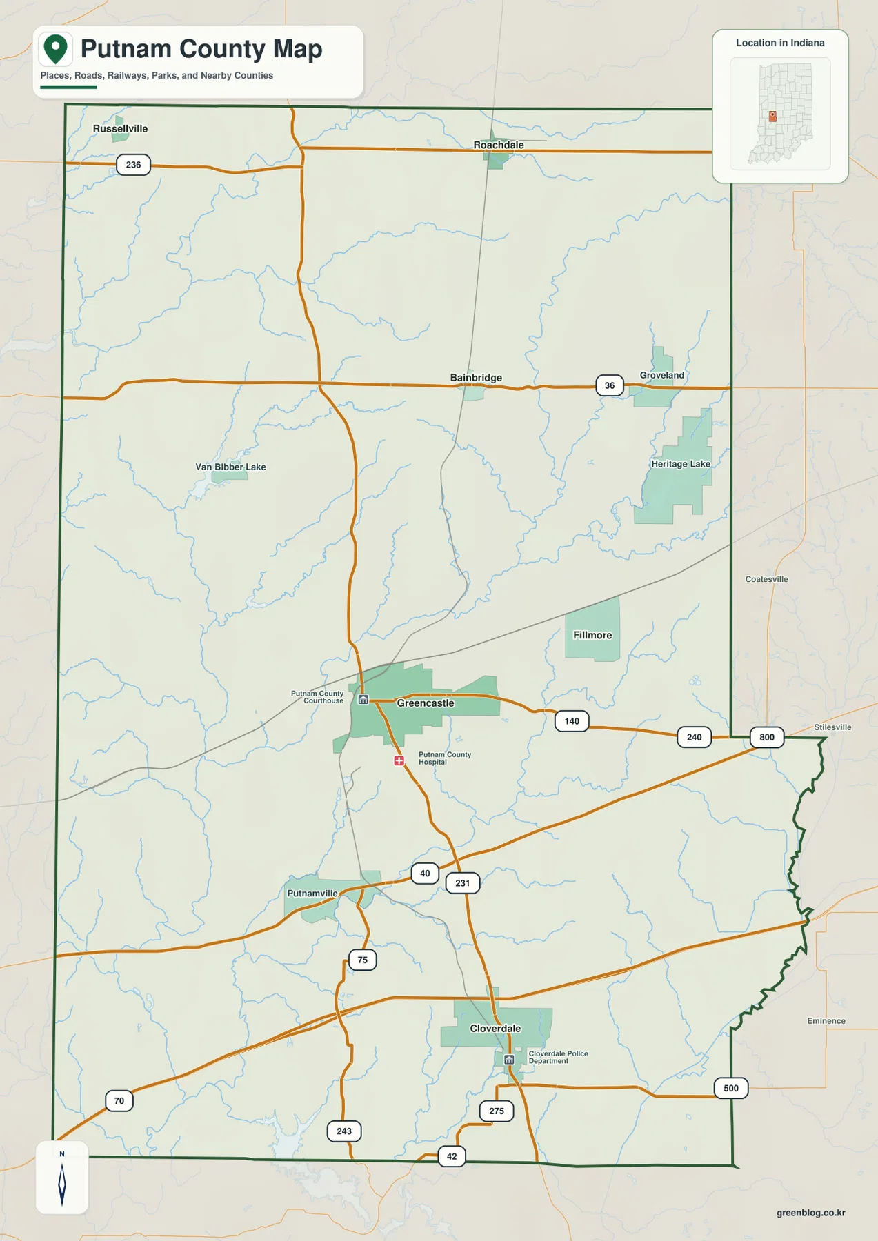
North of Greencastle, the road pattern adds two useful east–west references. Route 36 runs through the Bainbridge area, while Route 236 lies farther north near Roachdale and Russellville. The two routes are separated enough to make the northern part of the county easy to divide visually. Bainbridge sits closer to the US 231 corridor, Roachdale is farther northeast, and Russellville appears near the northwestern side. Fillmore lies east of Greencastle and helps define the central-eastern part of the county.
South of Greencastle, Cloverdale is the most prominent named settlement near US 231. Other numbered roads, including 42 and 275 near the southern part of the county, add local connections. Farther southwest, Routes 70 and 243 are also visible. The map is not intended to replace a current navigation service, but it is useful for answering basic questions such as which major highway is closest to a town, whether a place is north or south of Greencastle, and which road provides the clearest county-wide directional reference.
Several non-road features help with orientation as well. A rail line crosses the Greencastle area on a diagonal, Heritage Lake stands out near the irregular eastern county boundary, and Van Bibber Lake lies northwest of Greencastle. Once those landmarks are recognized, it becomes easier to move to the water map without losing track of the same parts of the county.
From Russellville and Roachdale south to Greencastle and Cloverdale
The city map highlights six settlements and removes much of the secondary linework found on the general map. Greencastle occupies the central position, Cloverdale lies well to the south, and the northern half is represented by Roachdale, Bainbridge, and Russellville. Fillmore is close to Greencastle on the eastern side. The result is a simple picture of a county whose principal settlements are spread over several directions rather than clustered along a single urban corridor.
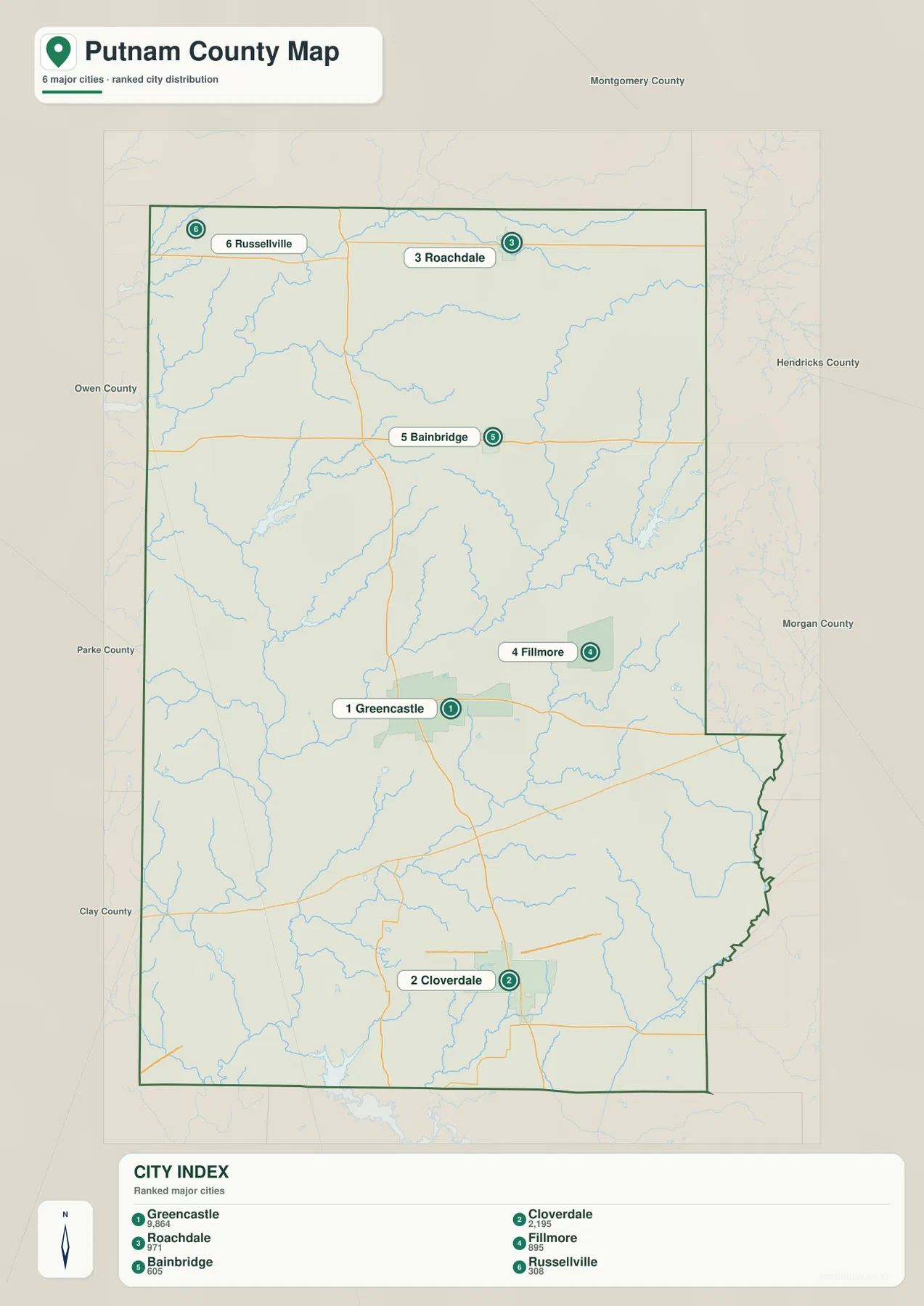
The numbered markers on this supplied city map are best treated as part of the map’s own ranking display rather than as a statement of the latest official population. For geographic orientation, the useful information is the placement of the towns themselves. Russellville is near the northwest, Roachdale is farther northeast, Bainbridge sits below the far northern tier, and Greencastle occupies the central area. Cloverdale then extends the settlement pattern into the south.
Switching back to the general map connects that settlement pattern with the highways. Bainbridge is near US 231 and Route 36, Roachdale and Russellville are associated with the Route 236 corridor, and Cloverdale sits close to US 231 south of Greencastle. Fillmore lies east of Greencastle rather than directly on the north–south chain. This makes the two maps complementary: one is cleaner for settlement position, while the other explains how the major roads pass among those places.
The city map does not provide road mileage or travel time between the highlighted places. It should not be used to invent straight-line or driving distances that are not printed on the source. For trip planning, use it to understand direction first, then use the general map or a current routing service for the actual road connection.
Big Walnut Creek links the central valleys while Heritage Lake anchors the east
Big Walnut Creek is the most prominent named waterway on the terrain-and-water map. It enters the county from the northeast, works its way toward the central interior, and then continues through a series of bends toward the south and west. Smaller tributaries join the main creek along the way. The shape is very different from the highway grid, and that difference is useful: once the reader knows where Greencastle and the main roads are, the creek map shows how the natural drainage ignores those straight directional lines.
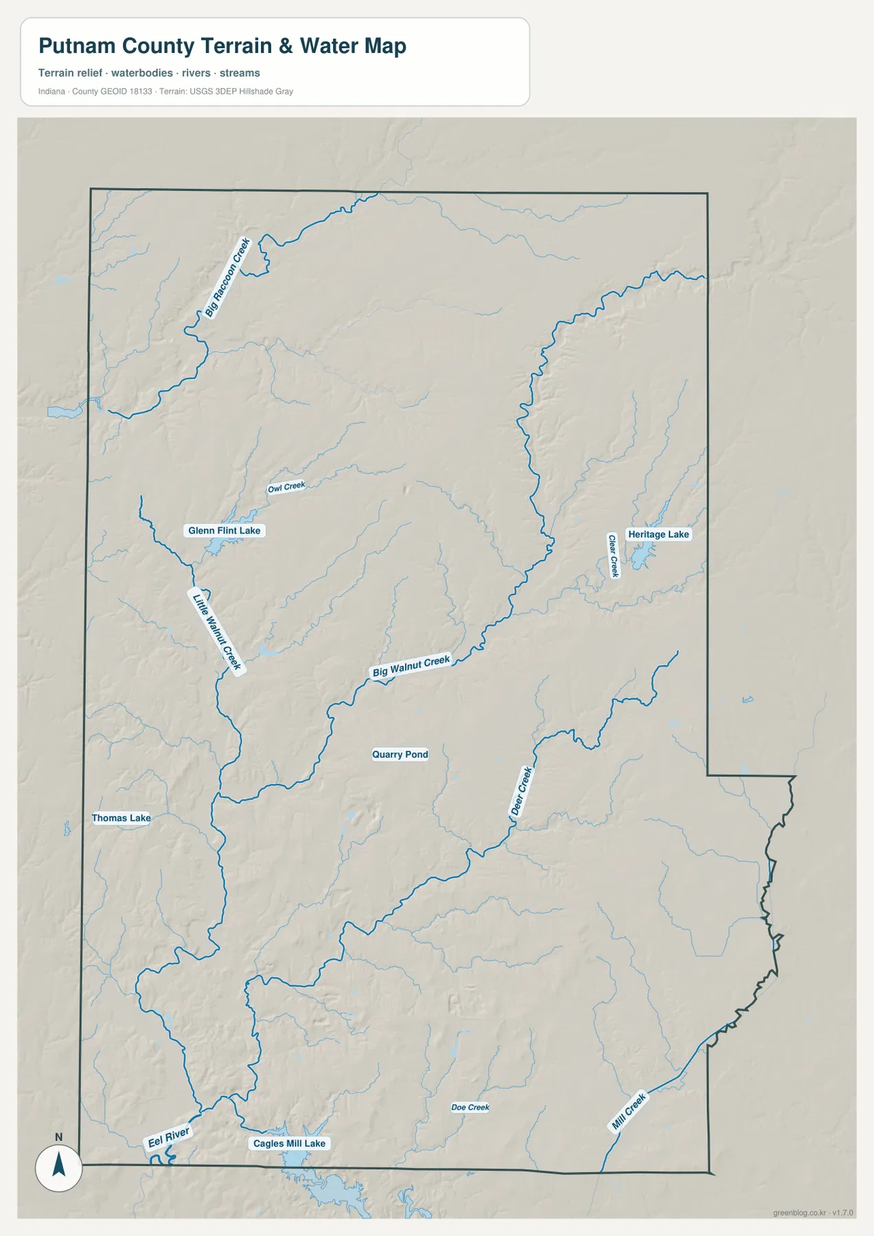
Heritage Lake is one of the easiest eastern landmarks to relocate from the general map. Clear Creek is shown in the same broad area, linking the lake district with the surrounding drainage. West of Greencastle, Little Walnut Creek adds another named branch, while Big Raccoon Creek forms a separate large valley across the northwest. These waterways do not all feed the county in one simple direction, so the specialized map is valuable when a reader needs to distinguish one creek system from another.
Farther south and southwest, the Eel River system and additional smaller tributaries appear. Van Bibber Lake provides another recognizable water landmark northwest of Greencastle. The mix of creeks, lakes, and tributary valleys explains why the county cannot be described by Big Walnut Creek alone, even though that creek is the dominant central feature. Looking at the full water map also helps separate the northwest Big Raccoon Creek valley from the central Big Walnut Creek corridor.
This is a county-scale reference map, not a flood-hazard map, parcel boundary map, legal drainage document, or boating chart. It is appropriate for locating named creeks and lakes and for comparing their general courses. Questions about current flooding, property boundaries, drainage responsibility, access, or recreation rules require the relevant current agency information.
A 175–302 meter landscape of low creek valleys and higher northeastern hills
The elevation legend shows an actual county range of about 175 to 302 meters, with a mean of 242 meters. Green represents lower terrain within the county display, while tan and brown mark higher ground. The central Big Walnut Creek corridor is easy to recognize because a lower green valley follows much of the same winding path visible on the water map. Broad lower terrain also extends into the southwest.
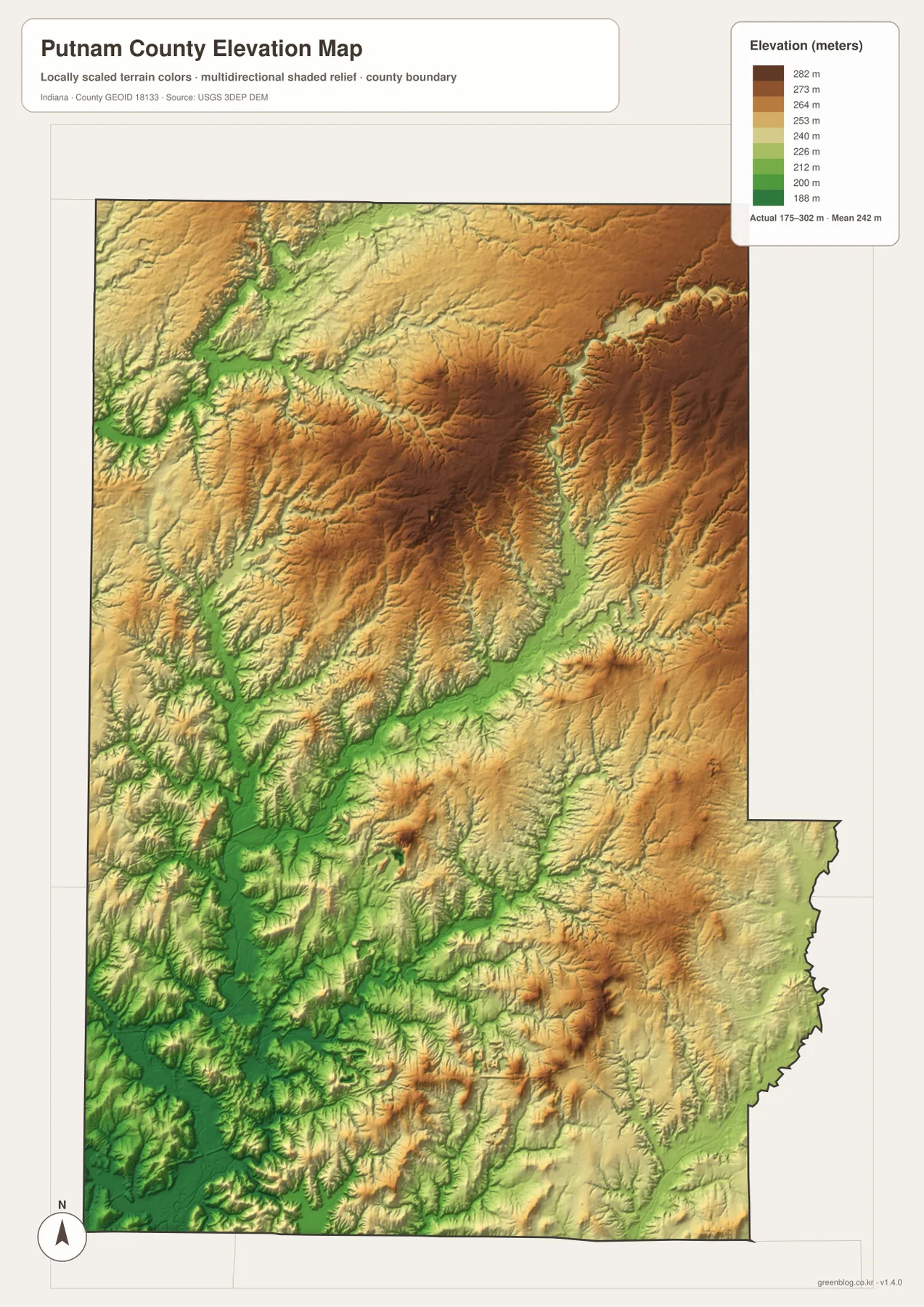
The northeast and north-central interior contain much more tan and brown shading. Those higher hills are cut by narrow green valleys where small streams descend toward the larger creeks. The Heritage Lake and Clear Creek area provides a good example: water features visible on the hydrography map correspond with lower passages through the surrounding relief. This is more informative than treating the eastern side as uniformly high, because the creek valleys interrupt the higher ground repeatedly.
Big Raccoon Creek creates another distinct low corridor in the northwest. Its valley cuts through surrounding higher terrain and is accompanied by smaller branches. In the southwest, the lower colors spread more broadly instead of being confined to one narrow valley. Comparing these areas shows that Putnam County has both incised creek corridors and wider lowland surfaces, with the strongest concentrations of higher relief farther northeast and north-central.
The elevation image is meant for county-wide comparison rather than site surveying. It can show where land is generally higher or lower and how valleys correspond to waterways, but it does not provide survey-grade elevations for a house lot, road profile, construction project, or engineering calculation. When an exact point elevation matters, source data such as the USGS 3D Elevation Program or a professional survey is the appropriate next step.
Choosing a map for highways, towns, creeks, or terrain
Use the general county map when you want the broadest combination of place names and transportation features. It keeps Greencastle, Cloverdale, Bainbridge, Roachdale, Putnamville, Heritage Lake, US 40, US 231, and other numbered routes in one frame. The city map is cleaner when the purpose is simply to compare the six highlighted settlements without the extra road and water detail.
For named waterways, move to the terrain-and-water map. Big Walnut Creek, Big Raccoon Creek, Clear Creek, Little Walnut Creek, the Eel River system, and the larger lakes can be traced more easily there. The elevation map answers a different question: it shows the shape of the ground surrounding those streams. Using the water and elevation maps together reveals why the creek corridors repeatedly match lower green valleys.
The WebP previews on this page are sized for convenient browser viewing. If you need to enlarge smaller creek labels or highway numbers, or if you plan to print the maps, use the original files in the download archive. The ZIP contains four high-resolution JPGs: the general county map, city map, terrain-and-water map, and elevation map. Each image is 2572 by 3638 pixels in portrait orientation.
A simple way to compare the maps is to keep Greencastle in view. Find it on the road map, check where the northern and southern settlements sit on the city map, move to the nearby Big Walnut Creek system on the water map, and then locate the same central valley on the elevation surface. Following one familiar area across the maps makes the differences between road, settlement, water, and relief information much easier to understand.
Frequently Asked Questions
Where should I start when reading the Putnam County maps?
Start with Greencastle. US 40 crosses the area from west to east and US 231 runs north–south, so the city makes a convenient reference for locating Bainbridge and the northern roads, Cloverdale to the south, and Heritage Lake to the east.
Which map is best for Big Walnut Creek and Heritage Lake?
The terrain-and-water map is the clearest choice. It shows Big Walnut Creek through the central interior, Clear Creek and Heritage Lake in the east, Big Raccoon Creek in the northwest, and several additional tributaries. The general map also shows Heritage Lake, but it contains fewer named water features.
Where are the strongest high-and-low terrain differences?
The legend reports an actual elevation range of about 175–302 meters and a mean of 242 meters. Lower green terrain follows the central Big Walnut Creek valley, the northwest Big Raccoon Creek corridor, and broad parts of the southwest, while higher tan and brown hills are more prominent in the northeast and north-central interior.
Map File Information
Download the high-resolution JPG originals for the Putnam County general map, city map, terrain-and-water map, and elevation map. The ZIP is the better choice when you need larger highway numbers, smaller creek labels, or print-quality images.
- Printable Size: 2572×3638 px each
Related Maps
Sources and References
The county-specific descriptions above are based on the supplied Putnam County maps and asset information. The official resources below are useful when current boundary, hydrography, or source elevation data is required.
- U.S. Census Bureau TIGER/Line Shapefiles – reference data for county boundaries, roads, and places
- USGS National Hydrography – official information for rivers, streams, and related hydrography
- USGS 3D Elevation Program – source elevation data and program information
Green Map creates custom-edited map images using open geographic data sources such as geoBoundaries, Natural Earth, OpenStreetMap, and government open data.
These maps are edited visual materials, not raw data files, and are provided for education, documents, presentations, and graphic reference.