Calhoun County sits in the inland farm country of southwest Georgia, west of Albany, with four small incorporated communities spread across a broad rural area. Morgan is the county seat near the center, Edison lies to the west, Leary is to the east, and Arlington is near the southwestern edge. This page brings those places together with the county boundary, state highways, creek network, and elevation pattern. The four map files can also be downloaded as high-resolution A3 JPGs in one ZIP for printing, classroom work, trip planning, or personal reference.
The county looks simple on a statewide map, but the local geography becomes more interesting when the layers are separated. Roads connect the small cities across a landscape cut by Ichawaynochaway Creek and many tributaries, while the terrain rises gradually toward parts of the west and northwest and drops into lower creek valleys toward the center, east, and southeast. The maps below are designed to make those differences easier to see without crowding every feature onto a single image.
Table of Contents
Calhoun County at a Glance
| State | Georgia |
|---|---|
| County and FIPS | Calhoun County · 13037 |
| County seat | Morgan |
| Created | 1854 from portions of Early and Baker counties |
| 2020 population | 5,573 |
| July 1, 2025 estimate | 5,413 |
| 2020 land area | 280.38 square miles |
| Incorporated cities | Morgan, Edison, Arlington, and Leary |
| Major waters | Ichawaynochaway Creek, Pachitla Creek, and the Chickasawhatchee Creek system |
| Download package | Four high-resolution A3 JPG maps in one ZIP |
The 2020 census counted 5,573 residents, while the July 1, 2025 estimate listed 5,413. With more than 280 square miles of land, Calhoun County has a low-density settlement pattern. That helps explain why the map contains wide spaces between municipal labels. Those gaps are not empty territory; they include farms, wooded tracts, creek bottoms, ponds, roads, and unincorporated communities. For that reason, the most useful way to read the county is to combine the city labels with the road and water layers rather than treating each town as an isolated point.
Morgan, Highways, and the County Boundary
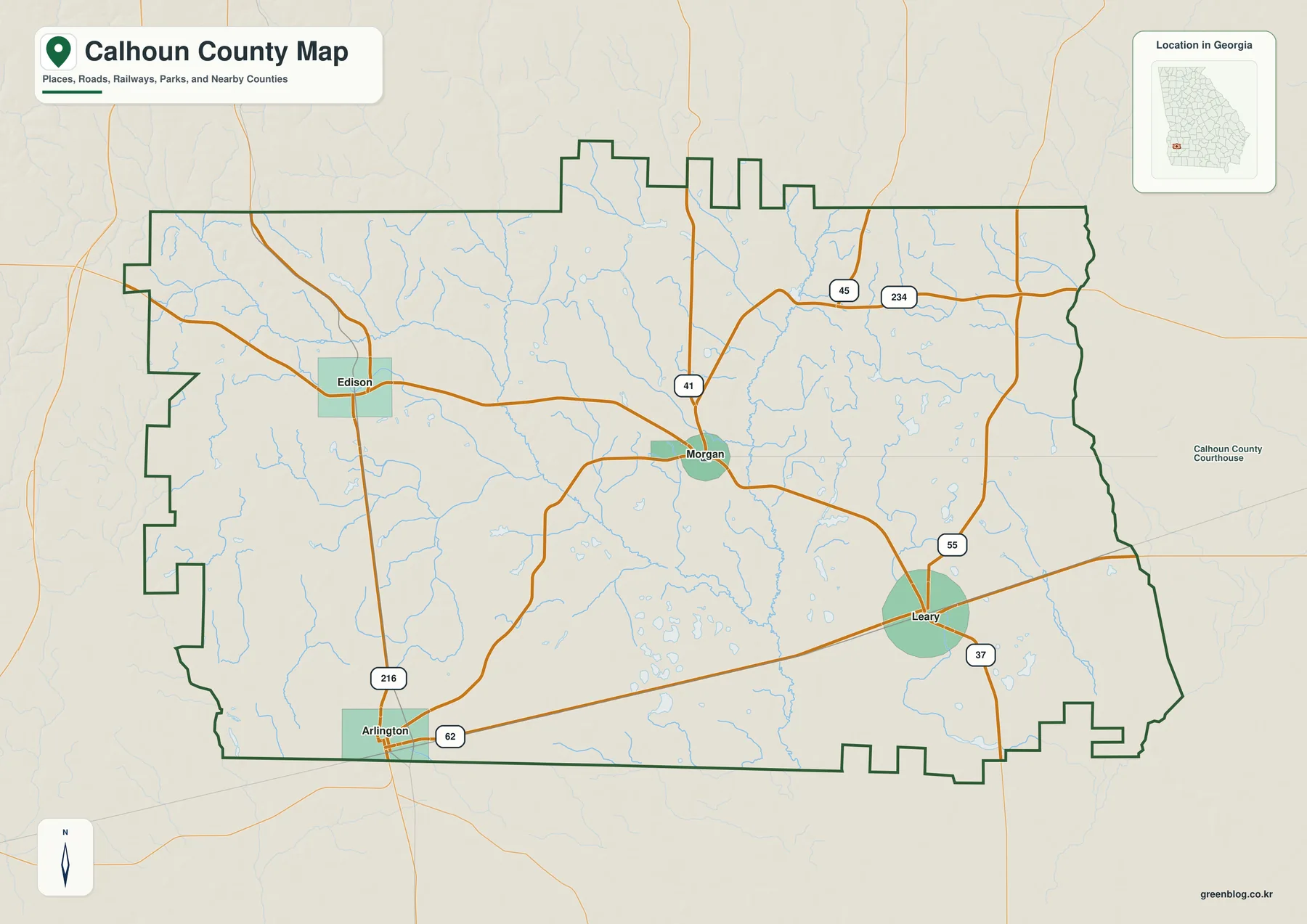
Morgan is the easiest starting point because it sits near the middle of the county and serves as the county seat. On the map, SR 37 runs west through Edison and east toward Leary, while SR 45 crosses the Morgan area on a north–south line. Those routes make Morgan a practical reference point even though it is a small city. The map also marks routes such as SR 234, SR 55, SR 62, and SR 216, which help show how travel branches away from the central east–west connection.
Edison appears west of Morgan, Leary lies east and slightly south, and Arlington is separated from that main alignment near the southwestern county edge. The shape of the county boundary is irregular in several places, especially along the western and southern sides, so a community can look close to Calhoun County while actually straddling or sitting beyond a county line. Arlington is the clearest example of why the boundary itself matters. For parcel ownership, mailing addresses, voting districts, or other legal questions, this general map should be followed by current county GIS or official address records.
The road pattern also shows why straight-line distance is not the whole story in a rural county. Creeks cross the same landscape that the state routes must traverse, and the practical route between two points depends on bridges and junctions. A short distance on the map can therefore involve a longer drive than expected. The county map is best for orientation: find Morgan, identify the direction of the other cities, then use the more specialized city and water maps to understand what lies between them.
How Morgan, Edison, Arlington, and Leary Are Spaced
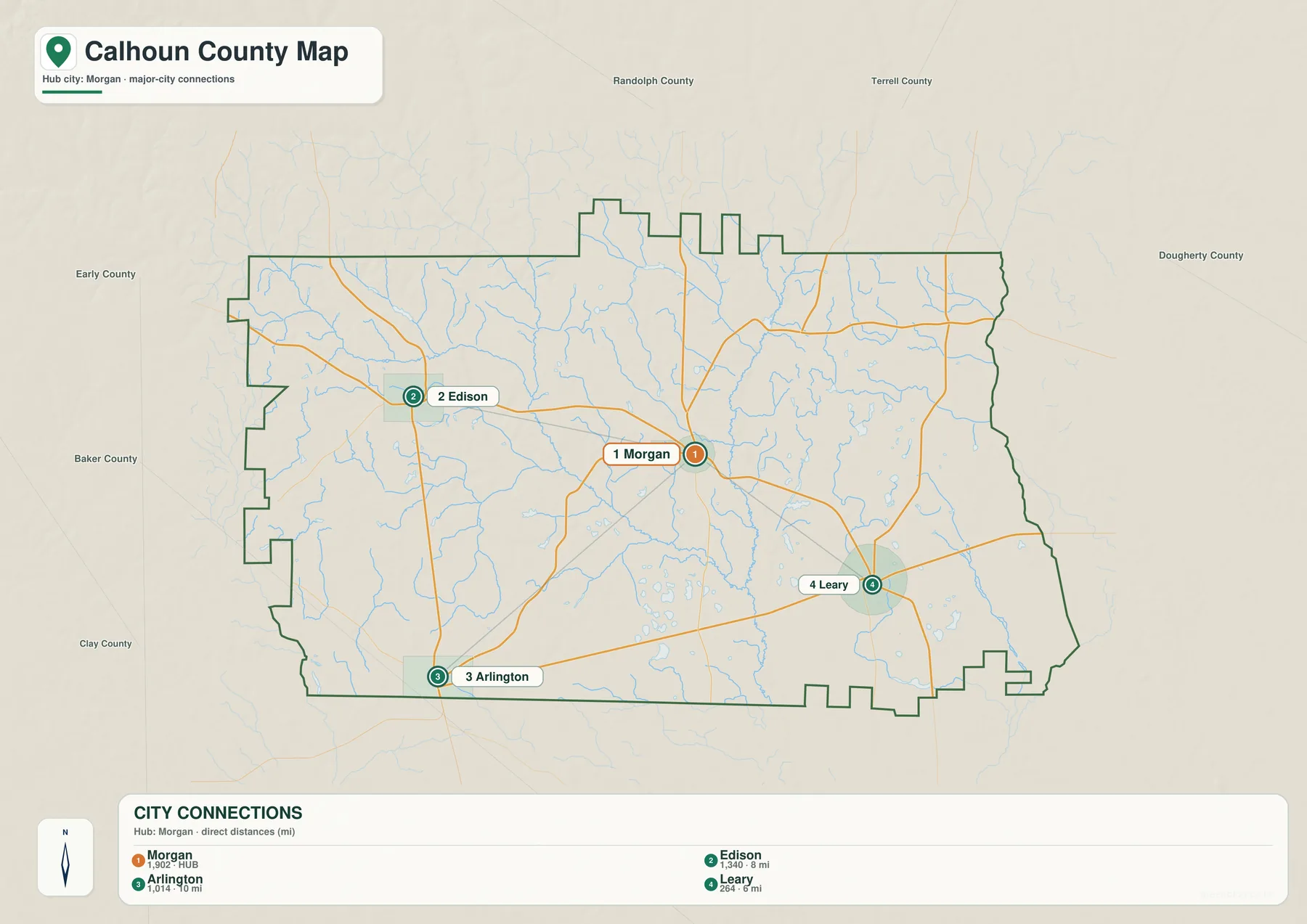
The city map strips away some of the background detail and makes the settlement pattern easier to compare. Morgan occupies the central reference position. Edison is west, Arlington is southwest near the county edge, and Leary is east-southeast. The connection panel shows that Leary is the closest of the three to Morgan, while Edison and Arlington are farther away. That uneven spacing is important because Calhoun County does not have one continuous built-up area; small communities are separated by miles of rural land.
Nearby county labels add useful context. Randolph and Terrell counties are to the north, Dougherty County lies toward the east, and Early, Baker, and Clay counties are on the western and southern side of the local region. Albany, in Dougherty County, is the major nearby urban center, so the eastern side of Calhoun County connects into a larger service area beyond the county line. The map therefore works better when read as part of southwest Georgia rather than as a self-contained island.
The local roles of the towns also differ. Morgan contains the courthouse and county government functions, while Edison is identified in the county background sources with the middle/high school and public library. Arlington and Leary serve their own surrounding rural areas. The city symbols should not be read as a population chart, and their marker sizes are not intended to rank the communities. Their purpose is to show where the places sit relative to one another and how a traveler or student can orient around Morgan.
Creek Valleys and Small Ponds Across Calhoun County
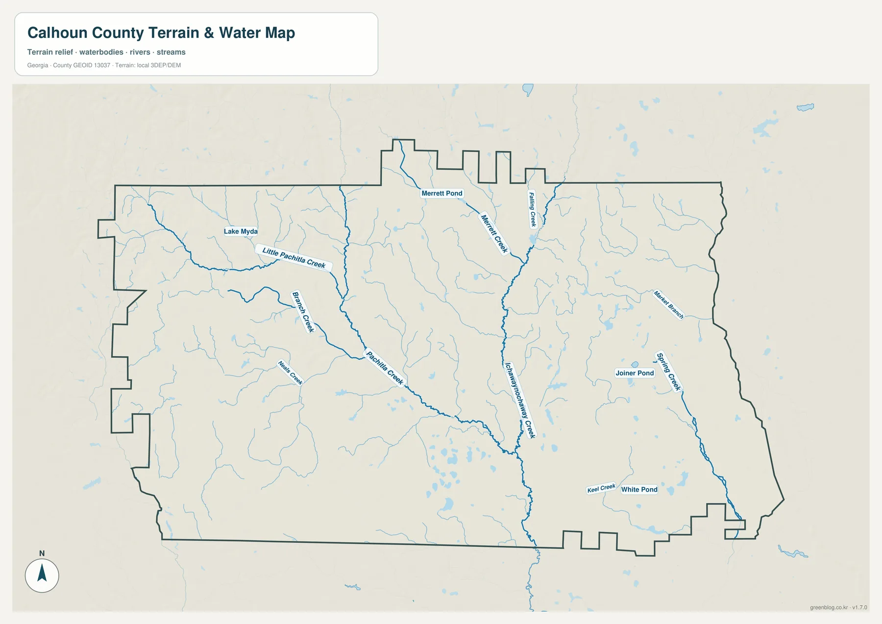
The water map reveals a much denser network than the general road map suggests. Ichawaynochaway Creek is a major feature through the central and southeastern part of the county, and the western side contains Pachitla Creek, Little Pachitla Creek, and smaller tributaries. Other named channels and branches extend through the east and south. Rather than forming one broad river valley, the county is divided by many smaller drainage lines that collect water from farmland and wooded ground.
Several small named water bodies are also visible, including Lake Myda, Merritt Pond, Joiner Pond, and White Pond. Calhoun County is not dominated by a large reservoir, but these ponds and tributaries matter at the local scale. Creek bottoms can carry more trees and wetter ground than the fields around them, and roads must cross or bend around the drainage network. Comparing this map with the county map helps explain why a route that looks direct on a blank outline may depend on a limited number of bridge crossings.
USGS monitoring information in the package includes an Ichawaynochaway Creek site near Morgan on GA 37 and a Chickasawhatchee Creek site near Leary. Those sources are appropriate when current water level information is needed. The map on this page is a geographic reference rather than a flood map: it does not establish a floodplain boundary, predict inundation, or show the safe elevation of a building site. Property-level flood questions should be checked against current FEMA mapping and local records.
A Gentle Drop from the Western Uplands to Lower Creek Country
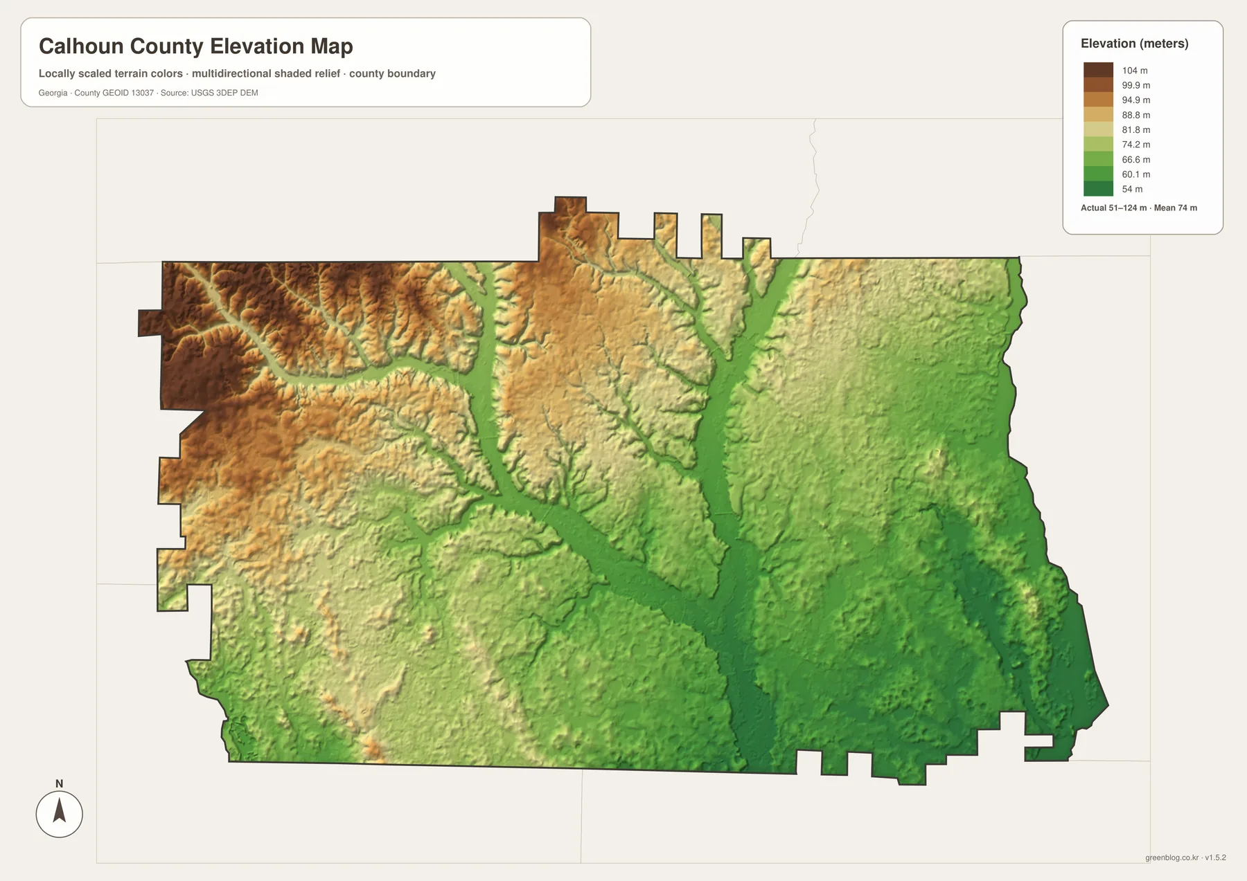
The elevation map gives an actual county range of roughly 51 to 124 meters, with a mean near 74 meters. Those numbers confirm that this is a low-relief landscape rather than mountainous country. Even so, the colors and shaded terrain show a clear internal pattern. The west and northwest contain more of the higher brown and tan ground, while broad green corridors extend through the center, east, and southeast where the principal creeks have cut lower valleys.
The northwest has the most obvious texture, with short ridges and branching hollows that stand out under the shaded relief. Moving eastward, the terrain becomes lower and visually smoother in many places. The low strips around the creek system line up with features seen on the water map, making the relationship between drainage and elevation easy to recognize. The difference is only on the order of tens of meters, but in farm country that is enough to influence where water collects and where roads cross the valleys.
The elevation colors are scaled for Calhoun County, so they should not be compared directly with the colors used on a map of a mountain county. This is also not a survey-grade surface. It is useful for learning the broad shape of the land, comparing parts of the county, and adding terrain context to the creek map. Construction, drainage design, engineering, and property decisions require more precise elevation or survey data.
Calhoun County in the Southwest Georgia Region
Calhoun County is an inland county west of Albany. The surrounding county pattern places it among Early, Baker, Dougherty, Terrell, Randolph, and Clay counties. On a statewide map, a useful way to locate it is to find Albany first and then move west into the agricultural interior between the city and the Alabama side of southwest Georgia. It is not directly on the Florida line, but it belongs to the same broad lower Georgia region of farms, small towns, pine woods, and creek systems.
Transportation reflects that rural setting. There is no single large interstate interchange anchoring the county. Instead, state routes connect the small municipalities and continue toward neighboring counties. Eastbound travel naturally leads toward Dougherty County and Albany, while western and southwestern routes serve Edison, Arlington, and communities beyond the Calhoun County line. Reading the city map together with the county map makes those outward connections easier to understand than looking at the county outline alone.
County Formation and Morgan’s Changing Seat Role
Georgia created Calhoun County in 1854 from portions of Early and Baker counties. The county was named for John C. Calhoun, who served as vice president under John Quincy Adams and Andrew Jackson. Morgan incorporated in 1856, and local history describes the courthouse location as a compromise reached by measuring between competing proposed county-seat sites. The present map makes that story easier to picture because Morgan sits near the middle of the county rather than on a distant edge.
Morgan did not hold the county-seat designation continuously. After a referendum, the Georgia legislature moved the seat to Arlington in 1923. Residents later petitioned for another change, and the seat returned to Morgan in 1929. The courthouse now associated with Morgan was rebuilt in 1935 after earlier courthouse buildings were lost to fires in 1888 and 1920. Seeing the separation between Morgan and Arlington on the city map gives that administrative history a real geographic scale.
Agriculture is another important part of the county background represented in the source material. More than half of the land has been described as prime farmland under U.S. Department of Agriculture criteria, and crops historically have included corn, oats, sorghum, and wheat. The broad rural spaces, many drainage channels, and small population centers shown on the maps fit that agricultural setting. These maps do not show current crop boundaries, ownership, or zoning, so they should not be used to identify what is being grown on a specific property.
Practical Ways to Use the Four Maps
For a first look at the county, begin with Morgan on the county map and follow SR 37 west to Edison and east toward Leary. Add Arlington southwest of that line, then switch to the city map to compare the spacing of the communities. The water map explains many of the blue lines crossing the road network, and the elevation map shows that those same drainage corridors occupy lower ground. Moving through the maps in that order builds a more complete picture without forcing the reader to interpret every symbol at once.
- For geography lessons, mark the four incorporated cities first and then add the neighboring counties to place Calhoun County within southwest Georgia.
- For a field trip or drive, use the maps for broad orientation but use current navigation and road-condition information for actual travel.
- For creek research, identify the waterway on the water map and then open the relevant USGS monitoring source for current observations.
- For terrain comparison, use the elevation map to distinguish the higher west and northwest from the lower creek corridors, not to obtain survey elevations.
- For print use, choose the A3 JPG files from the ZIP; the WEBP versions embedded in the article are optimized for browser viewing.
Frequently Asked Questions
Where are Edison, Arlington, and Leary relative to Morgan?
Edison is west of Morgan, Leary is east and slightly south, and Arlington is southwest near the county edge. Following SR 37 between Edison, Morgan, and Leary provides the simplest mental reference, with Arlington added below and to the southwest of that line.
Is Arlington entirely inside Calhoun County?
Arlington sits on the southwestern county boundary and should be read together with the Early County line. For an exact address, parcel, or jurisdictional question, use current official address records or county GIS rather than relying only on the general county outline.
Is Calhoun County flat?
It is a low-relief county, but it is not perfectly flat. The provided elevation map shows an actual range of about 51 to 124 meters, with higher ground in much of the west and northwest and lower terrain along creek valleys toward the center, east, and southeast.
Map File Information
Calhoun County A3 Map Files
- Included Files: Original high-resolution map files shown in this article
- File Type: Image files packaged in a ZIP archive
- Intended Use: Printing, education, presentations, and map-based projects
Related Maps
Sources and Reference Material
- U.S. Census Bureau QuickFacts – population, land area, density, and FIPS information
- New Georgia Encyclopedia: Calhoun County – county creation, towns, county-seat history, and local background
- Georgia Department of Community Affairs joint comprehensive plan – planning material for Morgan, Arlington, Edison, and Leary
- USGS: Ichawaynochaway Creek near Morgan – monitoring information for the Morgan area
- USGS: Chickasawhatchee Creek near Leary – monitoring information for the Leary area
Green Map creates custom-edited map images using open geographic data sources such as geoBoundaries, Natural Earth, OpenStreetMap, and government open data. These maps are edited visual materials, not raw data files, and are provided for education, documents, presentations, and graphic reference.