Wayne County is an eastern North Carolina Coastal Plain county where Goldsboro is the dominant urban and administrative center, but the map becomes much more useful when the outer settlements remain distinct. Mount Olive anchors the south, Fremont and Pikeville help organize the north, Eureka sits farther northeast, and Walnut Creek and Seven Springs provide eastern and southeastern references. Neuse River then adds a physical line through the middle of the county that town names alone cannot explain.
This page combines a general road-and-place map, a ranked six-city distribution map, and a terrain-and-water view centered on Neuse River, Little River, Northeast Cape Fear River, and the county’s network of creeks and swamps. The WebP previews are convenient for quick browsing. A ZIP containing the matching high-resolution A3 JPG files is available in the map file box below for printing, enlargement, or document use.
Table of Contents
Wayne County quick facts
- County seat and largest urban reference: Goldsboro
- Ranked city map: Goldsboro 34,383; Mount Olive 4,453; Walnut Creek 1,422; Fremont 943; Pikeville 776; Eureka 224
- Other general-map references include Dudley, Brogden, and Seven Springs
- Major road labels visible on the general map include 795, 70, 581, 111, 117, 55, 13, and 222
- Named water features include Neuse River, Little River, Northeast Cape Fear River, Stoney Creek, Falling Creek, and Nahunta Swamp
- Existing page context identifies Seymour Johnson Air Force Base as a major Goldsboro-area land-use and employment feature
The existing Wayne County page describes Goldsboro as the administrative and urban center, Mount Olive as a separate southern agricultural and food-processing reference, and Seymour Johnson Air Force Base as a major influence southeast of Goldsboro. It also uses Neuse River, Little River, and the Northeast Cape Fear drainage direction as physical references. Those source-derived points remain useful background, while the detailed map descriptions below stay with places, roads, waterways, and labels visible in the supplied package.
Goldsboro, the northern towns, and the Mount Olive south
Goldsboro is the strongest place-and-road reference on the general map. Route 70 crosses the central urban area, route 795 extends northward, and routes 581 and 111 help separate nearby directions. Wayne Community College and the 4th Medical Group–Seymour Johnson label also appear close to the city, reinforcing the concentration of administrative, educational, and military-related functions around the county center.
North of Goldsboro, Pikeville and Fremont form separate town references along the long northern section of the county, while Eureka sits farther northeast. These places do not merge into a continuous urban footprint. Their value is geographic: they divide the northern countryside into recognizable sections and make the Goldsboro-centered road map easier to use.
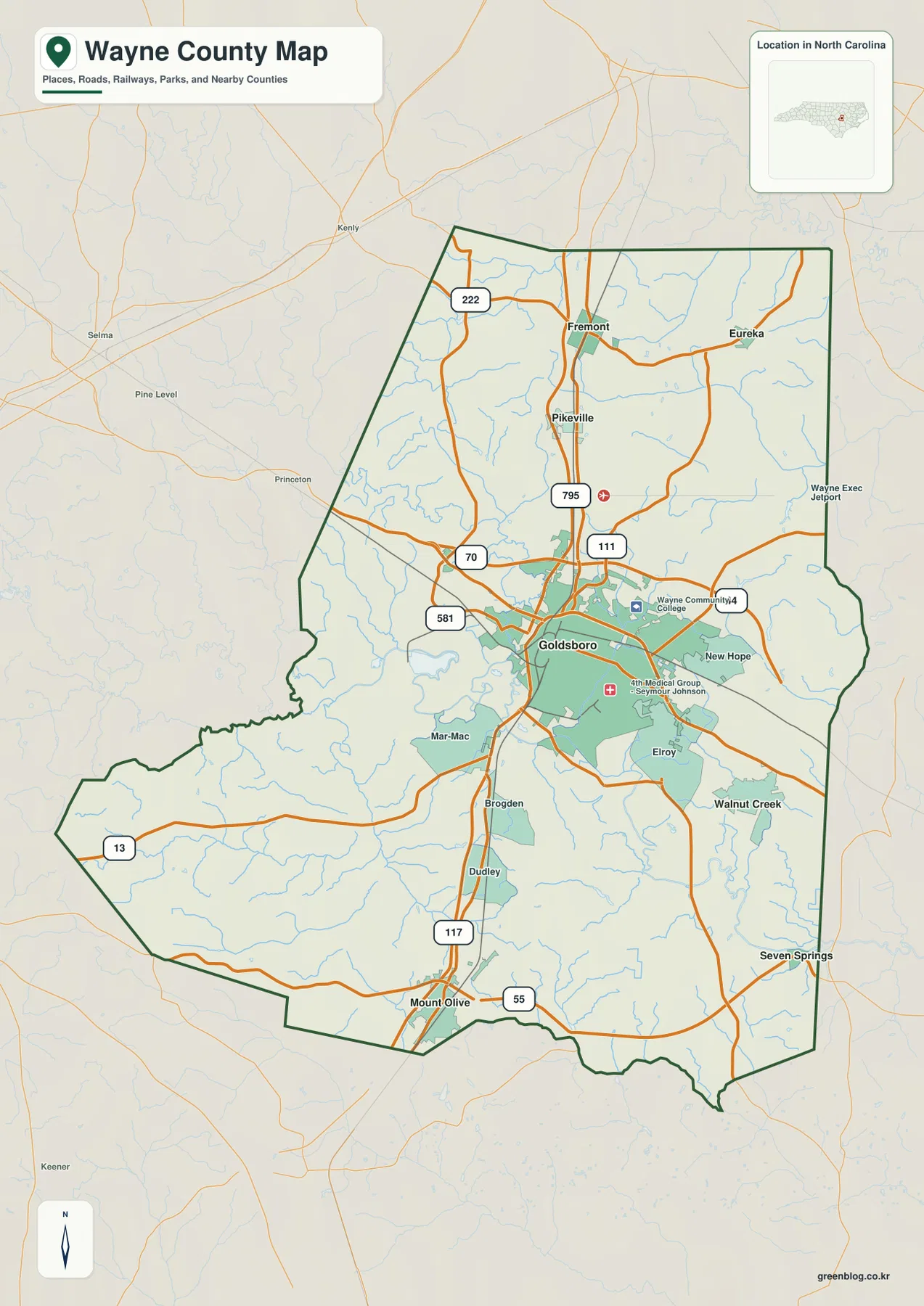
The south changes again. Dudley and Brogden appear between Goldsboro and Mount Olive, and route 117 provides a strong north-south reference before route 55 reaches the Mount Olive side. Mount Olive is therefore better treated as a separate southern center than as a simple extension of Goldsboro. The existing page’s agricultural and food-processing context fits this more dispersed southern setting.
Walnut Creek lies southeast of Goldsboro, while Seven Springs is farther east near the county boundary. Their positions show how settlement becomes smaller and more dispersed toward the Neuse-side countryside. Keeping those places distinct avoids reducing the eastern half of Wayne County to generic Goldsboro outskirts.
Neuse River and Little River organize the lowlands
Neuse River is the strongest large-water reference on the terrain map. It curves across the central part of the county and provides a physical anchor south and east of Goldsboro. On the road map, the county is easy to read from the city center outward; on the water map, the same area is divided by a large river and many smaller tributary valleys.
Little River runs through the northwestern and central-western interior toward the Neuse system. Quaker Neck Lake appears nearby as a smaller local reference. This western water corridor is useful because it gives the countryside a structure that is not visible from town names alone, especially between the Johnston County side and central Wayne County.
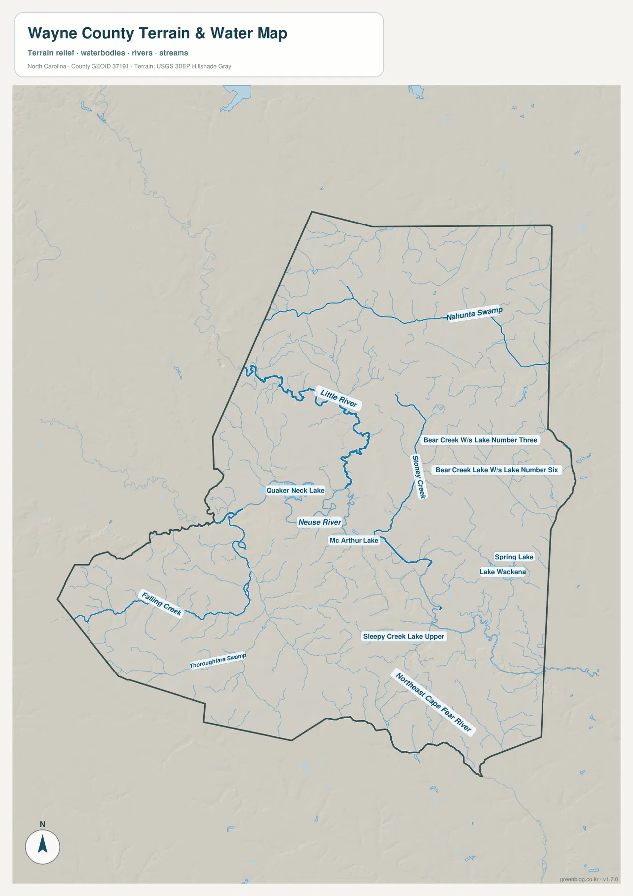
Nahunta Swamp is labeled across the northeastern part of the county, while Stoney Creek runs through the eastern-central interior. Several small Bear Creek lakes also appear in that area. These features show a low, stream-rich Coastal Plain landscape beyond the Goldsboro urban area, where waterways and wet ground become stronger local references than city blocks.
Falling Creek crosses the southwest, Thoroughfare Swamp appears farther south, and Northeast Cape Fear River is labeled along the southeastern side. That separate southern drainage matters when reading the Mount Olive and lower-county area. A Neuse-only description would miss the fact that the southern edge belongs to a different network of small streams and river corridors.
Relief is subdued compared with western North Carolina. The useful visual pattern is not steep mountain elevation but broad low terrain repeatedly cut by rivers, creeks, swamps, and small lakes. This terrain-and-water image is for general geographic orientation rather than flood determination, parcel boundaries, navigation, or survey-grade elevation.
Six ranked places show a dominant center and dispersed outer towns
The city-distribution map makes the scale difference obvious. Goldsboro ranks first at 34,383, Mount Olive second at 4,453, and Walnut Creek third at 1,422. Fremont follows at 943, Pikeville at 776, and Eureka at 224. Those are values printed on the supplied graphic and are not being presented here as independently updated population estimates.
Location matters as much as rank. Mount Olive is far south of Goldsboro, Walnut Creek is southeast of the central city, Fremont and Pikeville are north, and Eureka is farther northeast. The ranked list therefore represents several different parts of the county rather than a cluster of six places around one urban core.
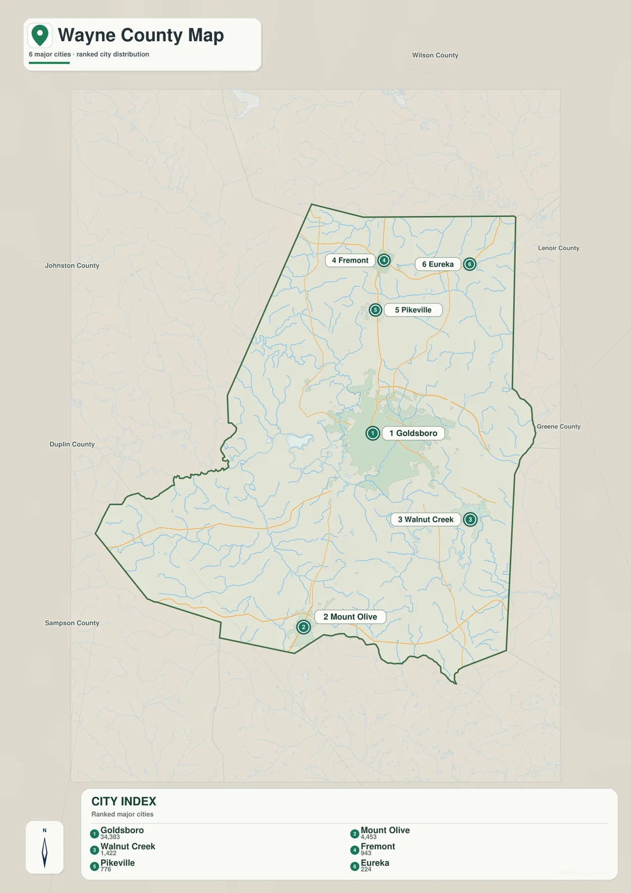
Goldsboro’s large lead in the ranking matches the dense central road network, but it does not mean that every important place belongs to one continuous metro area. Rural land and waterways separate Mount Olive from the center, and smaller communities in the north occupy distinct sections of the county. Seven Springs is not part of the six-place ranking, yet it remains useful on the general map for eastern orientation.
The outer city map labels Johnston, Wilson, Lenoir, Greene, Duplin, and Sampson counties. These names provide regional orientation only. They do not measure legal distance or driving time, and the Wayne County boundary remains the main reference for deciding which communities and waterways belong inside the county.
Keeping military, farming, urban, and river geography distinct
A practical reading order starts with Goldsboro for administration and roads, then separates Mount Olive in the south from Fremont and Pikeville in the north before adding the eastern and northeastern settlements. Neuse River and Little River can then be layered onto that settlement pattern as physical references, with Northeast Cape Fear River providing another important southern water direction.
Seymour Johnson Air Force Base is a major functional reference southeast of Goldsboro, but it should not be treated as the same kind of feature as a river or creek. The base belongs to the county’s urban and land-use story, while Neuse River and the smaller waterways describe the physical landscape. Keeping those layers separate makes the Goldsboro area easier to understand without flattening very different kinds of information into one category.
The general map is the best choice when numbered roads and named places matter. The city map makes the large Goldsboro-to-outer-town scale difference easy to compare, while the terrain-and-water map is more useful for Neuse River, Little River, Nahunta Swamp, and the southern drainage. Switching views by question is more effective than forcing every detail into one map.
The download archive contains three high-resolution A3 JPG files matching the Wayne County general map, city-distribution map, and terrain-and-water map. The WebP previews keep the page light for browsing, while the JPG originals retain more detail for printing, enlargement, and document placement, especially around small creek and swamp labels.
For Wayne County, this downloadable set is intended for broad place, road, and water orientation. Legal boundaries, surveying, flood determinations, navigation, and engineering-grade elevation work should rely on the relevant official Census, USGS, county, or other authoritative source data.
Frequently Asked Questions
What orientation problem does Neuse River solve on this county map?
Neuse River gives the central and eastern county a physical reference that is independent of Goldsboro’s urban importance. Read beside Goldsboro, Mount Olive, and Seven Springs, it shows how settlement locations sit within a broader lowland river landscape.
Why does Mount Olive need a separate role in the county description?
Goldsboro is the county seat and largest urban center, while Mount Olive anchors a separate southern agricultural and food-processing area. Keeping Mount Olive distinct makes the county map less dependent on a single Goldsboro-centered description and gives the southern section a clear settlement reference.
Map File Information
The ZIP contains three high-resolution A3 JPG files matching the Wayne County general map, city-distribution map, and terrain-and-water map shown on this page.
- Included Files: Three map versions: general county, city-distribution, and terrain-and-water
- File Type: High-resolution A3 JPG files in a ZIP archive
- Intended Use: Printing, education, presentations, and map-based projects
Related Maps
- Across the Rowan County North Carolina Map
- Across the Surry County North Carolina Map
- Alamance County Map
Sources
- Wayne County – General Information
- U.S. Census Bureau – TIGER/Line Shapefiles
- USGS – National Hydrography
- USGS – 3D Elevation Program
The county link provides Wayne County background, while Census and USGS links support boundary, road, hydrography, and terrain reference checks. The ranked city values, numbered roads, Neuse River, Little River, Northeast Cape Fear River, creeks, swamps, and small lakes described above are grounded in the supplied Wayne County map package.
Green Map creates custom-edited map images using open geographic data sources such as geoBoundaries, Natural Earth, OpenStreetMap, and government open data.
These maps are edited visual materials, not raw data files, and are provided for education, documents, presentations, and graphic reference.