Dale County Map resources on this page include four high-resolution JPG files that you can download together in one ZIP: a county map, city map, water map, and elevation map. Start with Ozark, the county seat, then follow the county outward toward Daleville and Fort Rucker in the southwest, Newton near the Choctawhatchee River, Midland City and Pinckard in the southeast, and Ariton farther northeast. Dale County sits in Alabama’s Wiregrass region, where county roads, small cities, military land, streams, and gently rolling terrain all shape how people move through the area.
Ozark is the easiest place to use as a reference point because it combines the county government center with the US 231 corridor. From Ozark, Daleville and Fort Rucker lie to the southwest, while Newton is useful for understanding the US 84 and Choctawhatchee River area. Midland City, Pinckard, and Level Plains help define the southeastern side of the county, and Ariton marks a different, more rural part of the northeast. Looking at these places together makes the county easier to understand than treating its boundary as an isolated shape.
Table of Contents
Dale County orientation from Ozark outward
Dale County is in southeastern Alabama. It borders Barbour County to the north, Henry County to the east, Houston County to the southeast, Geneva County to the south, Coffee County to the west, and Pike County to the northwest. The county lies within the Coastal Plain rather than a high mountain region, so the landscape is generally made up of low ridges, gentle hills, stream valleys, woodland, and agricultural land. That moderate terrain helps explain why settlements are spread across several corridors instead of being confined to one narrow valley.
The county overview is the best starting point if you need to understand where Dale County sits within southeastern Alabama. Find Ozark first, then compare the directions of Daleville, Newton, Midland City, Pinckard, Level Plains, and Ariton. Once those reference points are clear, the neighboring counties and the larger Dothan and Enterprise areas become easier to place in context. This view is especially useful for general orientation, school work, regional comparisons, and planning a closer look at roads or waterways.
Ozark, Daleville, and the main road corridors
Ozark is both the county seat and the strongest administrative center in Dale County. US 231 passes through the city and provides a clear north-south reference line. Southbound travel connects toward Dothan, while the same corridor leads north toward other parts of southeastern Alabama. Ozark also has Blackwell Field and aviation-related facilities, which connect the city’s civilian economy with the broader aviation identity of the county.
Daleville has a different role because it directly adjoins Fort Rucker. The city’s road network, services, housing, and daily traffic are closely tied to the military installation. US 84 and AL 85 are important in this part of the county, and the relationship between Daleville, the Fort Rucker gates, and nearby Enterprise is a key part of the southwestern map. Newton, farther west, is a useful reference for the point where the US 84 corridor and the Choctawhatchee River become part of the same geographic picture.
The city map is useful for comparing settlement patterns rather than simply reading a list of town names. After locating Ozark and Daleville, trace the southeastern communities of Midland City, Pinckard, and Level Plains, then look toward Ariton in the northeast and Newton in the southwest. This shows how the more connected southern and southeastern side of the county differs from the smaller rural communities farther north and east. If connector lines or city-to-city distance labels appear on this map, they should be treated as straight-line reference distances rather than road-driving distances.
Choctawhatchee River, Claybank Creek, and local drainage
The Choctawhatchee River is one of the most important water features for understanding southwestern and southern Dale County. It is especially helpful when viewed with Newton, Daleville, and the US 84 corridor. A road crossing over a major river is more than a cartographic detail: it shows where transportation depends on bridges and where low ground and stream valleys influence travel. The river also provides a clear way to relate Dale County to the larger drainage system that continues south through the region.
Claybank Creek is another useful feature around the Daleville area. U.S. Geological Survey records include a monitoring location on Claybank Creek near Daleville, and the stream ultimately belongs to the Choctawhatchee River system. Numerous smaller tributaries spread across the county as well. On a water map, the most useful approach is to follow the network rather than focus only on one named river. Smaller streams reveal how water gathers into larger channels and where valleys tend to run through the landscape.
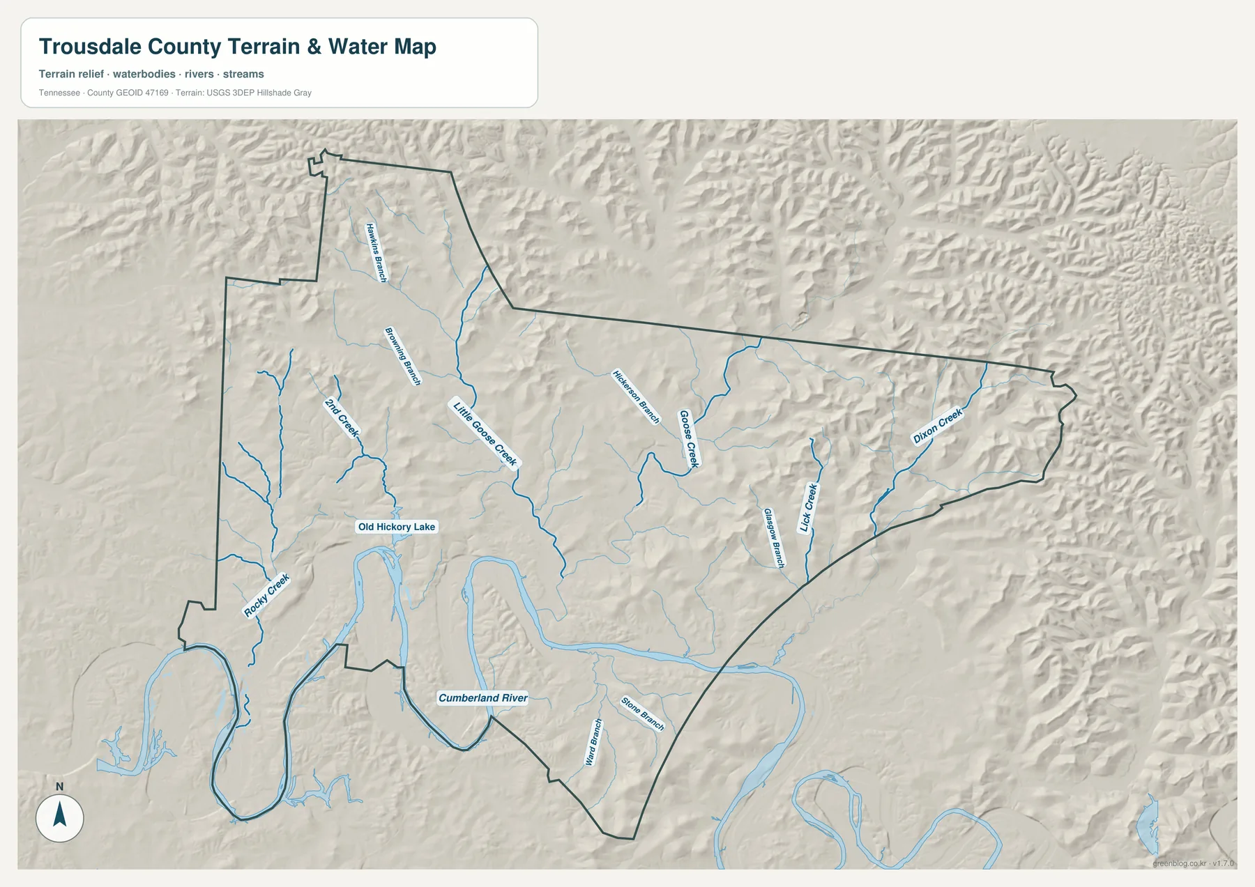
This is a water-reference map, not a flood-zone, navigation, parcel, or legal-boundary product. It can help you see where streams run and where the road network approaches or crosses water, but it should not be used for flood insurance or property decisions. For those purposes, official flood-hazard mapping and local records are required. As a general county reference, however, the water map adds natural geography that is easy to miss on a road-focused view.
Gentle hills, stream valleys, and elevation changes
Dale County is not a mountainous county, yet its surface is not completely flat. The Coastal Plain landscape includes gentle hills and low ridges separated by stream valleys. Those differences can be subtle when you only look at roads and city names, but an elevation view makes the pattern easier to notice. Lower ground generally follows drainage corridors, while higher ground appears between the stream systems. That relationship helps explain why the water and elevation maps are more useful when viewed together.
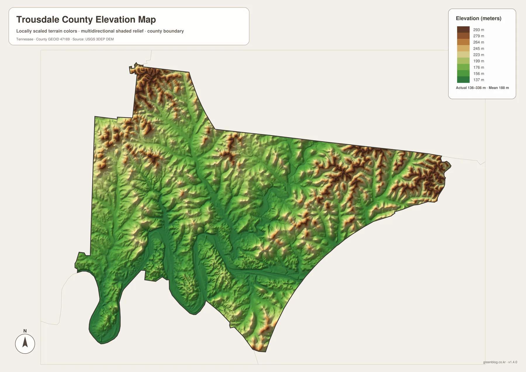
The elevation surface on this page is a generalized geographic reference and should not be treated as survey-grade or engineering-grade measurement. Its value is in showing broad changes across the county: where valleys are lower, where low ridges separate drainage areas, and how communities sit within the surrounding terrain. Switching between the county overview and the elevation view gives a much fuller sense of place than relying on either map alone.
Why Fort Rucker changes the map of Dale County
Fort Rucker is one of the defining geographic and economic features of Dale County. The U.S. Army describes the installation as a major center of Army Aviation training, and a substantial part of the main post lies in Dale County. Because the installation occupies a large area, the southwestern part of the county cannot be understood only as a collection of small towns and rural roads. Military land, gates, access routes, housing, services, and nearby civilian communities all influence the layout.
The installation’s name also changed recently, which matters when comparing maps from different years. It became Fort Novosel in 2023 and was redesignated Fort Rucker in 2025. A map or document created during the 2023-2025 period may therefore use Fort Novosel even though current Army material uses Fort Rucker. The two names refer to the same installation, not separate places.
Choosing the most useful map for your purpose
Use the county overview when your main question is where Dale County sits and how its communities relate to the county boundary. Choose the city view when you want to compare Ozark, Daleville, Newton, Midland City, Pinckard, Level Plains, and Ariton. The water map is better for following the Choctawhatchee River, Claybank Creek, and smaller tributaries, while the elevation map adds the broad terrain that lies underneath the road and settlement pattern. For school projects or regional research, using two or more views together is usually more informative than treating any one map as a complete description of the county.
Frequently Asked Questions
Are Fort Rucker and Fort Novosel the same place?
Yes. The Army installation was renamed Fort Novosel in 2023 and redesignated Fort Rucker in 2025. Maps produced during those years may use either name depending on their publication date.
Can the water map be used as a flood map?
No. It is a general reference for rivers, creeks, and tributaries. Flood zones, insurance decisions, building requirements, and property-specific questions require official flood-hazard and local government data.
What is included in the downloadable ZIP?
The archive contains four high-resolution JPG files: a county map, city map, water map, and elevation map. The WebP images shown in the article are page previews, while the download package provides the original JPG versions.
Map File Information
Dale County high-resolution map set
- Included Files: County map, city map, water map, and elevation map
- File Type: Four high-resolution A3 JPG files
- Intended Use: Printing, education, presentations, and map-based projects
Related Maps
Sources and references
County orientation and local details were checked against the Dale County Commission, U.S. Census Bureau QuickFacts, Alabama Department of Transportation map resources, Fort Rucker official community information, and U.S. Geological Survey water records.
Green Map creates custom-edited map images using open geographic data sources such as geoBoundaries, Natural Earth, OpenStreetMap, and government open data. These maps are edited visual materials, not raw data files, and are provided for education, documents, presentations, and graphic reference.