Sanilac County occupies the eastern side of Michigan’s Thumb, where a long Lake Huron shoreline meets an inland network of small towns, state highways, and branching streams. Sandusky sits near the middle of the county, while Croswell and Lexington are farther southeast, Marlette and Brown City are toward the west and southwest, and Deckerville is north of the center. M-46 crosses the county through Sandusky, M-25 follows the Lake Huron side, and M-53 and M-19 help define travel through the interior. High-resolution map files are available for download in the section below.
This page brings those features together with a county road map, a ranked city index, a water map, and an elevation map. The high-resolution A3 JPG files can be downloaded as one ZIP, so the maps can be printed, saved for reference, or used separately in a local geography project. The emphasis is on features visible in the supplied maps rather than on parcel, zoning, or engineering information.
Table of Contents
A road network centered on Sandusky
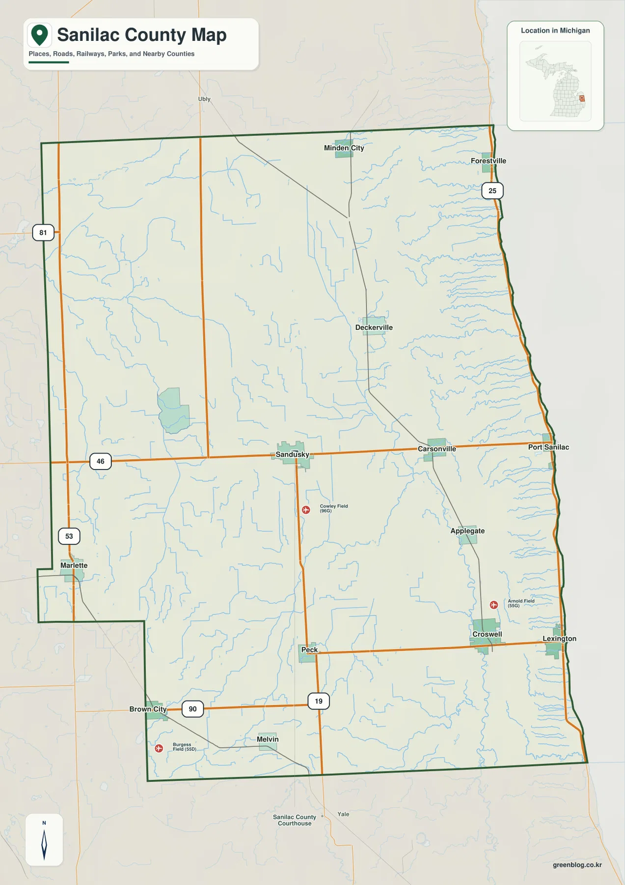
The county map makes Sandusky an easy orientation point because it lies close to the center and is crossed by M-46. From there, the same east–west route continues toward Carsonville and Port Sanilac, reaching the Lake Huron side. M-19 runs south from the Sandusky area toward Peck, while M-53 is shown near Marlette on the western side. Along the shore, M-25 connects a sequence of lakeside places including Forestville, Port Sanilac, and Lexington.
The settlement pattern is spread across the county rather than concentrated in a single urban area. Minden City and Deckerville appear in the north and northeast, Carsonville and Applegate lie between the center and the shore, and Peck, Melvin, Brown City, and Marlette mark parts of the south and west. The map also labels the county boundary clearly, making it easy to distinguish Sanilac County from Huron County to the north and the inland neighbors shown to the west and southwest.
For general orientation, this is the most useful of the four files because roads, place names, county limits, small watercourses, and the Lake Huron edge appear together. It can answer simple questions such as whether a town is closer to the shoreline or the western boundary, which numbered route passes near a community, and how the central road network relates to smaller places. It is not a turn-by-turn navigation map, so current road conditions and detailed local streets should be checked separately.
Six communities in the ranked city index
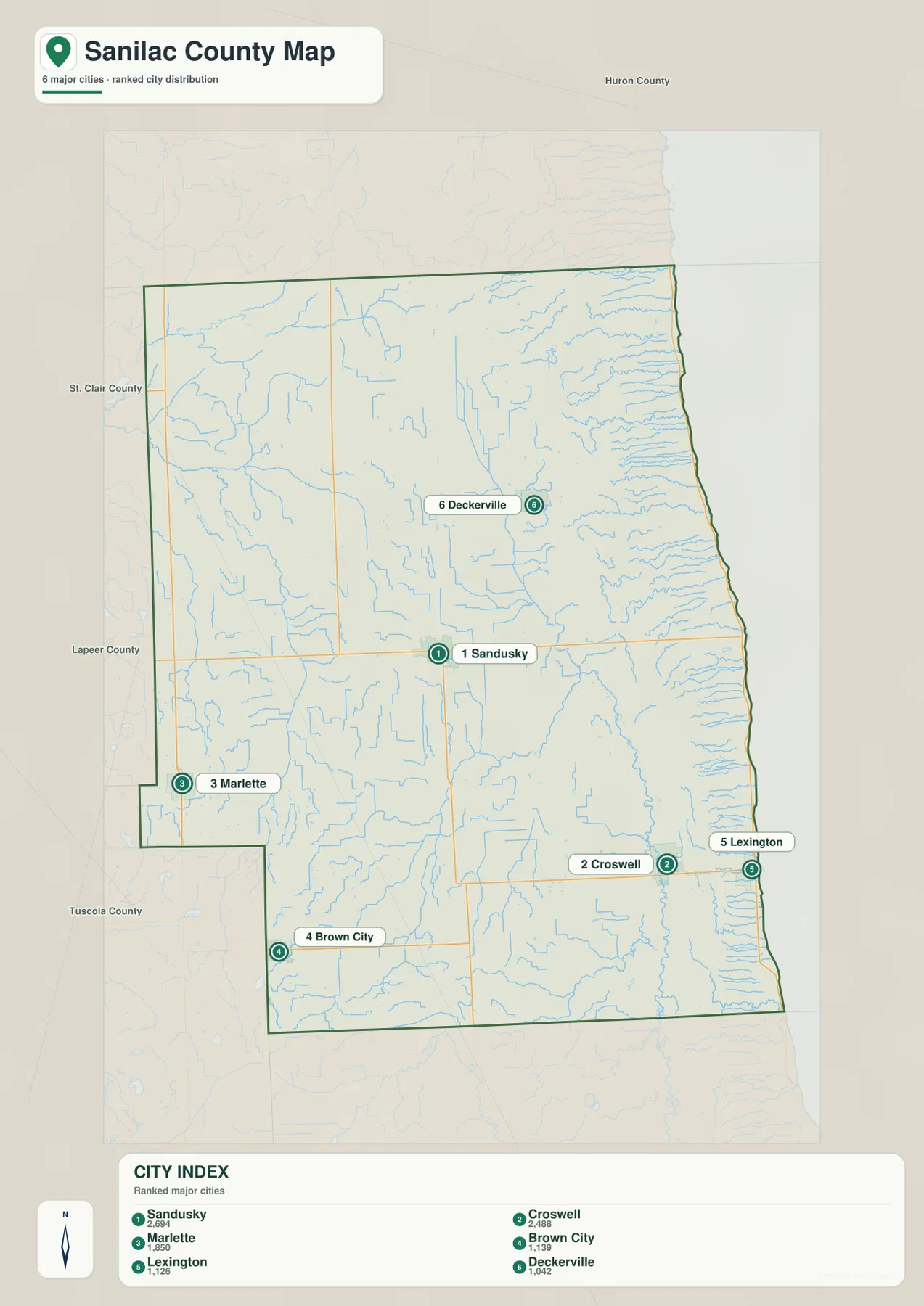
A separate city index removes much of the road detail and highlights six selected communities. Sandusky is ranked first and is positioned near the center of the county. Croswell is second in the southeast, Marlette is third near the western side, Brown City is fourth in the southwest, Lexington is fifth on the Lake Huron side, and Deckerville is sixth in the northeast. Their spacing shows how the county’s larger communities are distributed across several different parts of the map.
The values printed in the supplied index are 2,694 for Sandusky, 2,488 for Croswell, 1,850 for Marlette, 1,139 for Brown City, 1,126 for Lexington, and 1,042 for Deckerville. These figures are presented here only as the values displayed in the map’s index; this article does not replace them with a different population estimate or assign them to a year that is not printed on the map. The ranking is therefore best used as a companion to the location markers.
There are no connector lines or mileage labels on this city map. It should not be read as a straight-line distance chart, and it does not show driving distance between the six places. Use it to compare location and rank, then return to the county map when a road route matters.
Cass River branches in the west and short Lake Huron tributaries in the east
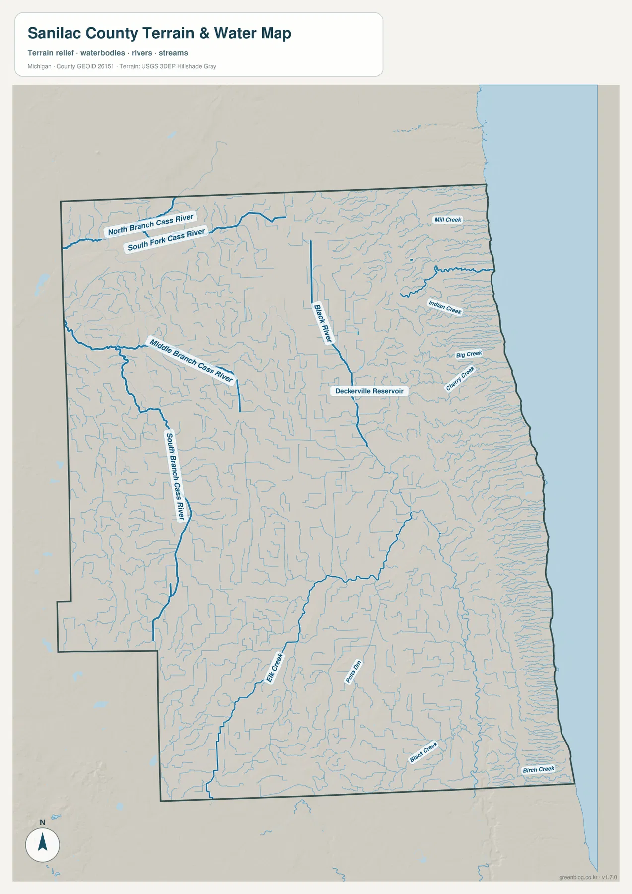
Sanilac County’s drainage becomes much clearer on the water map. In the northwestern part of the county, the North Branch Cass River and South Fork Cass River are labeled close to one another. Farther south, the Middle Branch Cass River and South Branch Cass River occupy different parts of the western interior. Seeing the four names together explains why the western half of the county cannot be summarized by a single river line.
The Black River is another prominent feature and is labeled near Deckerville Reservoir. Closer to Lake Huron, a dense set of shorter streams reaches the eastern side of the county. Mill Creek, Indian Creek, Big Creek, and Cherry Creek are named in the northeast and east, while Elk Creek, Black Creek, and Birch Creek appear farther south. The coastline provides a clear outer edge for these smaller waterways and makes the contrast with the longer Cass River branches especially easy to see.
This file is useful for locating named rivers, creeks, the reservoir, and the shore in relation to the county boundary. It is not a flood map, depth chart, navigation product, or legal water-boundary record. Anyone making a flood-safety, construction, drainage, or property decision should use the current specialized data from the appropriate public agency.
A low Lake Huron edge and higher inland ground
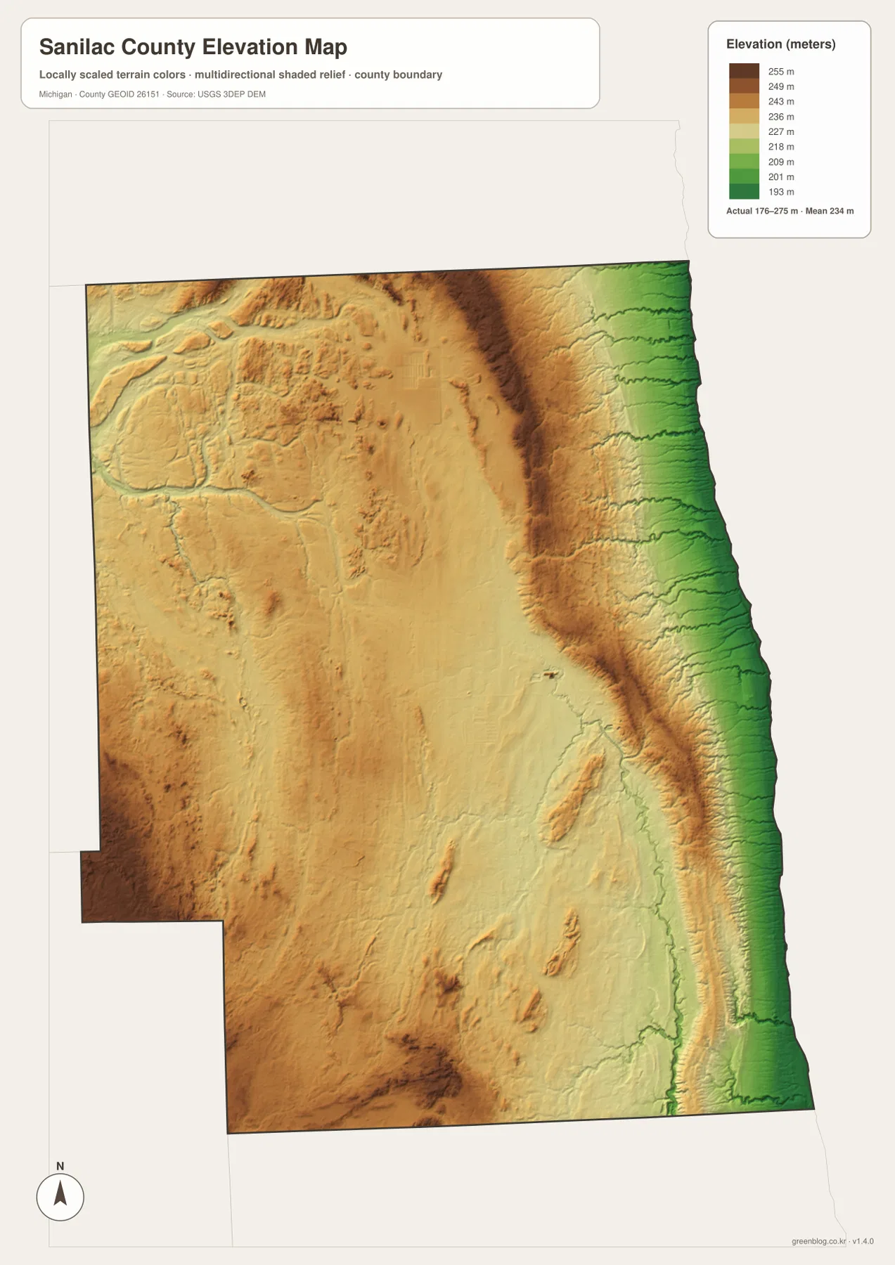
The elevation map reports an actual range of about 176 to 275 meters, with a mean near 234 meters. Low green tones form a long strip beside Lake Huron on the eastern edge. Moving inland, the colors shift through yellow and brown, showing that much of the interior stands above the immediate lakeshore. The county is not mountainous, but the shaded relief makes its modest ridges and shallow valleys much more visible than they are on the road map.
Higher ground is especially noticeable across portions of the north-central interior and in several western and southern areas. Stream corridors cut lower lines through that surface, while the coastal margin remains consistently lower. Small elongated rises can also be seen in the central and southern interior. Together, those features help explain why a county that appears broadly flat at road-map scale still has local relief that affects the shape of drainage and the appearance of the landscape.
The elevation file is intended for regional comparison, not survey work. Its colors and shaded relief are appropriate for seeing the difference between the lakeshore, stream valleys, and inland uplands, but they should not be used as an exact elevation measurement for a building site, road project, or drainage design. Detailed USGS elevation products and site-specific measurements are the better sources when a few meters matter.
Choosing the map that fits the question
For a quick county overview, start with the road and place map. It is the only file that combines the boundary, main communities, state routes, rail lines, small watercourses, and nearby county context in one view. It works well when locating Sandusky relative to the shoreline, comparing M-25 with inland routes, or finding communities such as Marlette, Peck, Carsonville, and Port Sanilac.
The city index is better when the six ranked communities are the main subject, because the large numbered markers are easy to scan without extra road detail. The water map is the stronger choice for following the different Cass River branches, Black River, Deckerville Reservoir, and the short eastern creeks. When the question concerns the low shore or higher inland ground, the elevation file provides a clearer answer than either of the line-based maps.
For classroom work, local history notes, or a presentation, the files can also be paired. A place can first be located on the county map, then compared with nearby waterways or elevation in the corresponding thematic file. None of the maps should be substituted for parcel records, zoning documents, legal boundaries, or engineering surveys, but they provide a practical geographic overview of Sanilac County.
Download the A3 JPG map files
The ZIP below contains the same four subjects discussed on this page as high-resolution A3 JPG files: the county/road map, ranked city index, water map, and elevation map. They can be kept together as a set or opened individually for printing and reference.
Frequently Asked Questions
Which map is best for finding Sandusky and the main highways?
Use the county map first. Sandusky is near the center, M-46 crosses the county through the area, and M-19 extends south. The same map also shows M-25 along Lake Huron and M-53 on the western side, so it is the clearest file for comparing towns and major routes.
Does the city index show driving or straight-line distances?
No. The city index shows ranked locations for six selected communities and prints an index value for each one, but it contains no connector lines or mileage labels. Driving distance depends on the road route and should be checked with a current navigation source.
Can the elevation map be used for construction or survey measurements?
No. It is a regional terrain reference that shows the broad difference between the low Lake Huron edge, stream valleys, and higher inland ground. Construction, drainage, and boundary work require more detailed official elevation data and site-specific surveying.
Map File Information
The ZIP contains the Sanilac County boundary/road, city index, water, and elevation maps as high-resolution A3 JPG files.
- Included Files: county map, city index map, water map, elevation map
- File Type: JPG
Related Maps
Sources and References
- U.S. Census Bureau TIGER/Line Shapefiles — official geographic boundary and transportation reference data.
- USGS National Hydrography — official U.S. Geological Survey information for rivers, streams, and water features.
- USGS 3D Elevation Program — official national elevation data and terrain resources.
- Sanilac County Road Commission — local official road information for Sanilac County.
- Michigan History Center — Sanilac Petroglyphs — a state resource describing a Sanilac County historic site along the Cass River.
Green Map creates custom-edited map images using open geographic data sources such as geoBoundaries, Natural Earth, OpenStreetMap, and government open data. These maps are edited visual materials, not raw data files, and are provided for education, documents, presentations, and graphic reference.