Saginaw County lies in east-central Michigan’s Lower Peninsula, where a broad lowland, several major rivers, and a dense road network meet around the city of Saginaw. Zilwaukee and Freeland sit to the north, Frankenmuth and Birch Run occupy the southeast, and St. Charles and Chesaning anchor the southwest. This page explains the county’s settlements, highways, waterways, and relief from the supplied maps, and the same high-resolution A3 JPG map files are available together in a downloadable ZIP archive.
The defining geographic feature is the meeting of large rivers near Saginaw. The Tittabawassee River approaches from the northwest and the Shiawassee River rises from the south, while the Cass River and Flint River systems enter from the east and southeast. Their low valleys converge near the central part of the county before water continues north in the Saginaw River. I-75, I-675, M-46, M-13, M-47, and other state routes occupy the same broad landscape, so the maps reveal a close relationship between river corridors, urban areas, and regional travel routes.
Table of Contents
Roads and communities around Saginaw
On the county map, Saginaw is the most prominent urban center and sits near Buena Vista, Shields, and the Saginaw River. Zilwaukee appears just to the north between I-75 and the river, while Freeland lies farther northwest near M-47. M-46 crosses the county from Merrill toward Saginaw and continues east, and M-81 leaves the Saginaw area toward Reese. These east-west routes intersect a series of north-south roads, producing a network that looks much denser around Saginaw than in the agricultural southwest.
I-75 follows the eastern side of the county and passes the Bridgeport and Birch Run areas. I-675 branches from I-75, loops close to central Saginaw, and reconnects on the north side of the urban area. M-13 runs south from Saginaw toward Bridgeport, while M-54 and M-83 are visible in the southeastern road network. Farther southwest, M-57 and M-52 serve the Chesaning and Oakley area, and St. Charles occupies a separate corridor closer to the center of the southern half of the county.
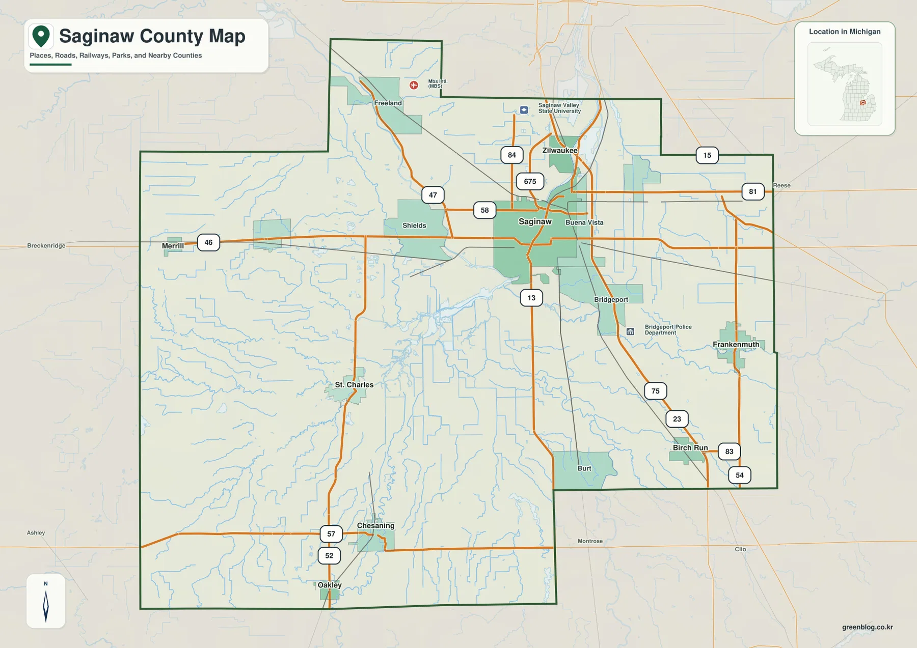
Saginaw County has an irregular outline rather than a simple rectangle. Midland and Bay counties are shown to the north, Tuscola and Genesee counties to the east, Shiawassee County along the southern side, and Gratiot County to the west. Places outside the boundary, including Breckenridge, Montrose, and Clio, provide useful orientation for the edges of the map. These labels help readers understand regional position, but the map is not intended for parcel surveying or legal boundary determination.
Saginaw Valley State University is marked north of the main Saginaw urban area, providing another recognizable reference point. Frankenmuth appears as a distinct community in the southeast, while Birch Run is farther south near the I-75 corridor. Chesaning and St. Charles sit well away from the central urban cluster in the southwestern part of the county. The result is a county in which settlement is spread along several roads and river corridors instead of being concentrated in a single continuous city.
Six ranked communities on the city index
The city index highlights six places: Saginaw, Frankenmuth, Chesaning, St. Charles, Zilwaukee, and Birch Run. Saginaw is ranked first, followed by Frankenmuth and Chesaning. The numbers printed beside the place names come from the dataset used to build the index and should not automatically be treated as current official population totals. For current demographic figures, readers should consult the U.S. Census Bureau or the relevant local government.
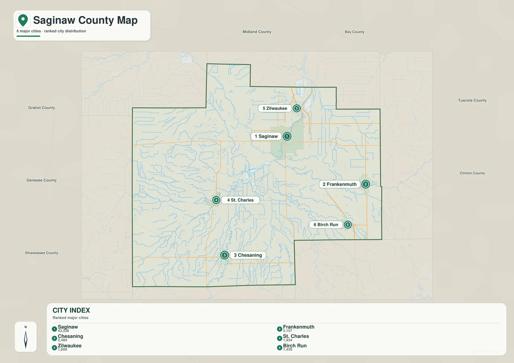
This city index does not draw connector lines between the communities, so it is not a distance map. The ranking numbers do not represent miles from Saginaw, and the map should not be used to estimate drive times. Its strength is spatial orientation: Saginaw and Zilwaukee occupy the northeastern urban area, Frankenmuth and Birch Run are farther southeast, and Chesaning and St. Charles are southwest of the central river system.
The surrounding labels for Midland, Bay, Tuscola, Genesee, Shiawassee, and Gratiot counties make the city index useful for broader orientation. A reader can first locate a road or town on the detailed county map and then switch to the city index to see where that place sits within the county as a whole. For actual travel planning, however, current navigation services remain necessary because road closures, construction, and travel times are not represented here.
The river confluence that defines central Saginaw County
The terrain and water map makes the county’s drainage system much easier to understand. The Tittabawassee River enters from the northwest, and the Shiawassee River approaches from the south. Near the middle of the county, those large waterways converge with the broader system that becomes the Saginaw River and then continues north. The Cass River reaches the area from the east, and the Flint River runs in from the southeast. Few other features explain the shape of central Saginaw County as clearly as this concentration of major river valleys.
Western Saginaw County contains the North Branch Bad River, South Fork Bad River, and Fork Bad River, along with Beaver Creek and many smaller channels. Lake Cecil and Lakewood Lake are also labeled west of the main river confluence. South of Saginaw, the Shiawassee River is surrounded by numerous smaller waterways and drainage features, while Birch Run is marked near the Flint River system in the southeast. The density of blue lines shows that water extends far beyond the major named rivers.
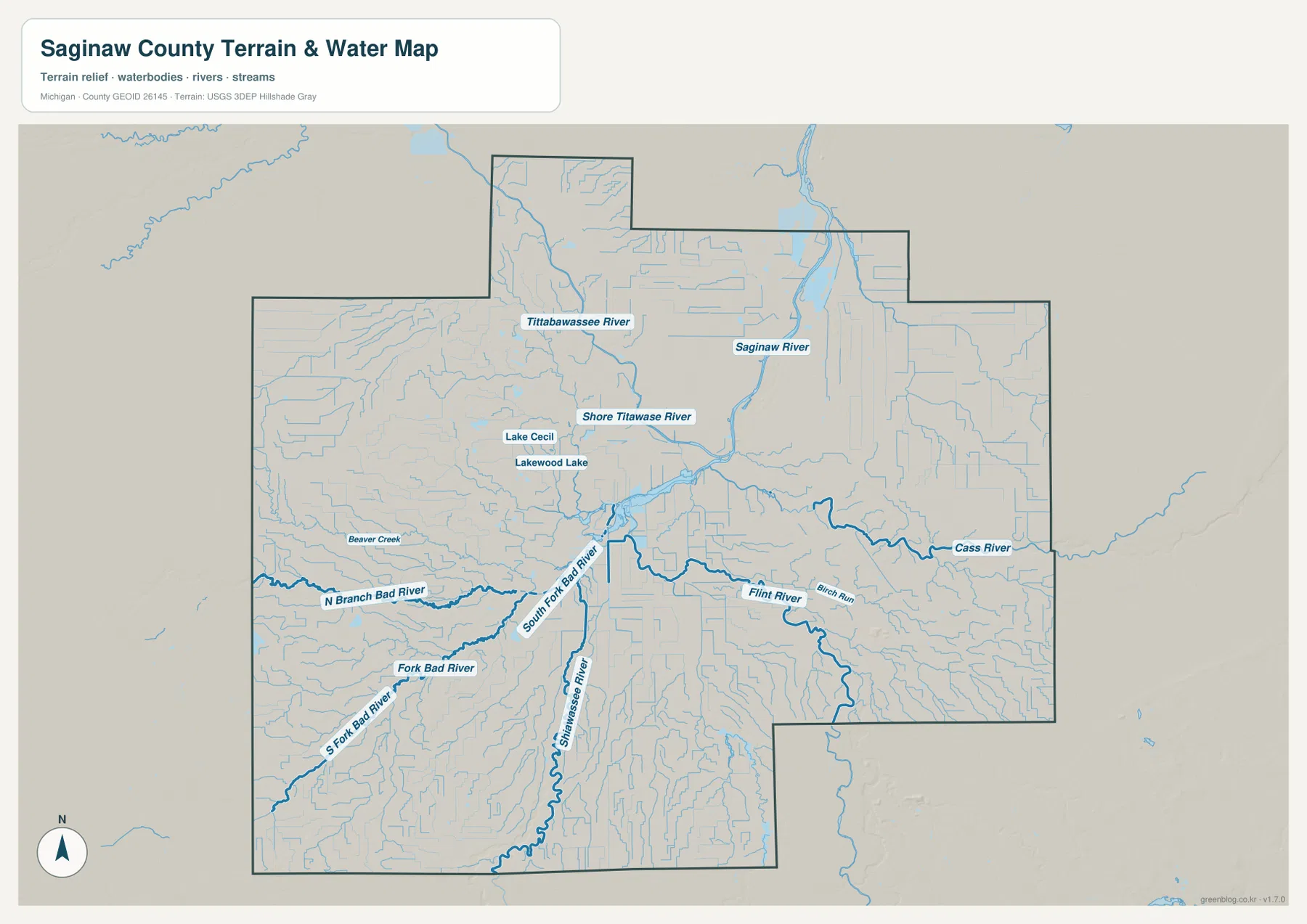
The Saginaw River then runs north through the urban area toward Bay County. Its corridor closely overlaps the low center of the elevation map and the developed Saginaw–Zilwaukee area shown on the road map. By contrast, tributaries in the west and south travel long distances through more rural parts of the county before reaching the center. Looking at the network as a whole helps explain why the county has a broad valley landscape instead of a single narrow river gorge.
This is a reference map of rivers, streams, and water bodies rather than a flood-risk, navigation, depth, or property-access map. Low terrain in the Saginaw Valley makes flood information especially important for some practical decisions, but those decisions require current FEMA and local government products. Fishing and boating rules also change by location and season, so Michigan Department of Natural Resources guidance should be consulted before field use.
Low central valleys and slightly higher outer edges
The elevation map shows a county that is generally low and gently rolling rather than mountainous. Dark green covers much of the central area around the Saginaw River and the major confluence. Lower bands also follow the Tittabawassee and Shiawassee rivers, while the Cass and Flint river valleys can be traced from the east and southeast. These low corridors align closely with the waterways on the terrain map.
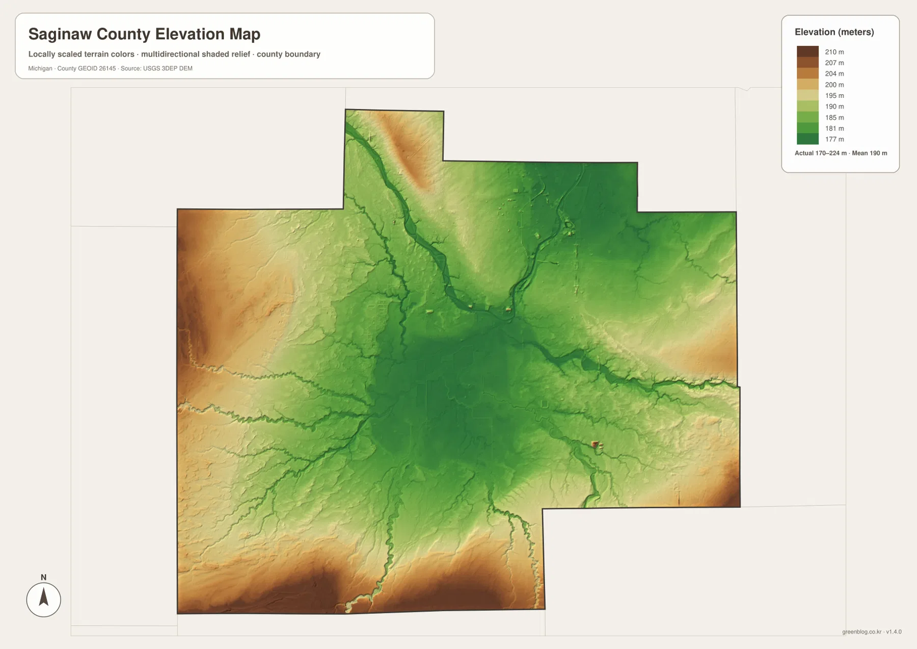
The legend uses representative colors from about 177 to 210 meters, while the map notes an actual terrain range of roughly 170 to 224 meters and a mean near 190 meters. Warmer browns and oranges appear more often along the western edge and southern margin, indicating ground that is higher than the central valley. The northwest is interrupted by the lower Tittabawassee River corridor, and the eastern edge also rises gently away from the main valley without developing into a mountain landscape.
These elevations are generalized for county-wide comparison. They are useful for seeing where the main valleys sit and how the outer margins rise, but they are not survey-grade measurements for individual parcels, roads, levees, or building sites. Engineering, drainage, construction, or flood studies require more detailed USGS elevation products and, when appropriate, professional field surveying.
Combining the elevation and water maps reveals a consistent pattern. The Tittabawassee and Shiawassee rivers descend into the same broad lowland, while the Bad River tributaries come from higher western ground. The Flint and Cass rivers also approach from slightly higher terrain before entering the lower central area. Roads and bridges cross these corridors repeatedly, so real-world travel or emergency planning should always be checked against current transportation and local safety information.
Comparing Saginaw roads, rivers, and relief for different uses
The general county map is the best starting point for locating Saginaw, Frankenmuth, Birch Run, Chesaning, and the major road corridors. It makes the relationship between I-75, I-675, M-46, M-13, M-57, and nearby communities easy to compare. The city index removes most of that detail and is better for a quick view of the six selected ranked places.
For rivers and tributaries, the water map carries far more detail. It shows where the Saginaw River begins, how the Tittabawassee and Shiawassee rivers approach the confluence, and where the Cass, Flint, and Bad River systems fit into the county. The elevation map adds a third layer of explanation by showing why the river corridors occupy broad low areas and why parts of the western and southern edge stand slightly higher.
In a classroom or presentation, pairing the road map with the water map is an effective way to discuss how transportation and settlement developed around the river system. The elevation map can then show that the central drainage network sits within a shallow regional lowland rather than a steep canyon. These maps are designed for regional reference and visual comparison, not for legal surveys, parcel decisions, real-time traffic, or flood determinations.
Saginaw County’s official website provides current county services and local government information. County Parks and Recreation materials add context for parks and the Saginaw Valley Rail Trail, while the Library of Michigan’s Saginaw County guide collects historical references and county background. For the underlying categories of geographic data, the U.S. Census Bureau and USGS provide authoritative boundary, hydrography, and elevation resources.
Saginaw County map downloads and practical uses
The download ZIP contains the original JPG versions of the general county map, city index, terrain and water map, and elevation map used on this page. Each image is 3638 × 2572 pixels in A3 landscape format. The files are suitable for screen viewing, classroom handouts, presentations, regional reference, and personal printing. Their generalized styling is not intended for cadastral work, legal boundary interpretation, flood certification, navigation, or real-time transportation decisions.
For printing, preserving the original aspect ratio helps keep highway shields and smaller place labels readable. A cropped enlargement of the general map works well when the focus is Saginaw or Frankenmuth, while the water map is better for river-based explanations. The elevation map is the most direct choice for showing the low central valley and the slightly higher western and southern margins. Using the four maps together gives a more complete view without forcing one map to carry every type of information.
Frequently Asked Questions
Do the numbers on the city index show distances from Saginaw?
No. The city index ranks Saginaw, Frankenmuth, Chesaning, St. Charles, Zilwaukee, and Birch Run, but it does not draw distance connectors between them. Use a current navigation service when you need mileage, drive time, or route conditions.
Where does the Saginaw River begin on the map?
The water map shows the Tittabawassee and Shiawassee rivers approaching one another southwest of Saginaw, with the resulting major channel continuing north as the Saginaw River. The river then passes the Saginaw and Zilwaukee area on its way toward Bay County.
Can the 170–224 meter elevation range be used as a parcel elevation?
No. That range summarizes terrain across the county and is appropriate for comparing the low central river valleys with higher outer areas. Parcel, construction, drainage, roadway, or engineering work requires finer USGS data and, when needed, professional survey measurements.
Map File Information
A ZIP file containing high-resolution JPG versions of the Saginaw County general, city index, water, and elevation maps.
- Included Files: county map, city index map, water map, elevation map
- File Type: ZIP containing 4 JPG files
Related Maps
Sources and references
- Saginaw County, Michigan — county government and local services
- Saginaw County Parks and Recreation – Rail Trail Brochure — local park and Saginaw Valley Rail Trail context
- Library of Michigan – Saginaw County Guide — county history and reference materials
- U.S. Census Bureau – TIGER/Line Shapefiles — county boundary and base geography data
- U.S. Geological Survey – National Hydrography — rivers, streams, and waterbody data
- U.S. Geological Survey – 3D Elevation Program — elevation and terrain data
Green Map creates custom-edited map images using open geographic data sources such as geoBoundaries, Natural Earth, OpenStreetMap, and government open data. These maps are edited visual materials, not raw data files, and are provided for education, documents, presentations, and graphic reference.