Lee County lies in the mountain country of eastern Kentucky, where steep ridges and narrow valleys shape nearly every road, creek, and settlement. Beattyville sits near the center of the county at the meeting place of major river forks, giving the town an unusually clear geographic role on the maps. The set on this page separates county boundaries and roads, the main city, waterways and terrain, and elevation so that each feature remains easy to see. The original high-resolution JPG map files can also be downloaded from the file box later on the page.
The Lee County government identifies the county as part of Kentucky’s Eastern Coal Field and notes that it was created in 1870. Its official overview gives a county elevation range of roughly 610 to 1,367 feet above sea level. Those figures match the broad story visible in the supplied elevation map: low river corridors twist through a much higher landscape of close-set ridges. For a small county, Lee has a remarkably intricate physical layout, and the maps help explain why travel routes, communities, and streams all follow the valleys rather than a simple grid.
Table of Contents
Beattyville as the road and county-seat anchor
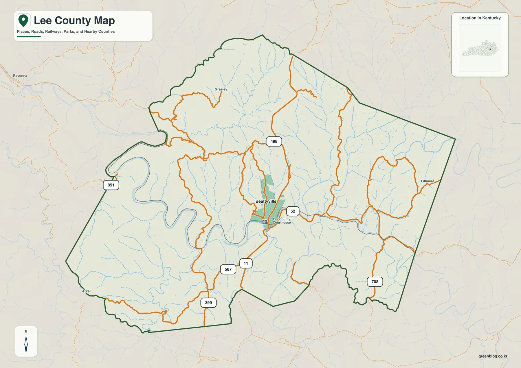
The general county map makes Beattyville the easiest place to locate. The developed area is highlighted near the center, and the Lee County Courthouse label reinforces its role as the county seat. Kentucky Route 11 runs through the area on a generally north-south course, while Route 52 extends eastward. Other numbered roads, including 498 to the north, 587 and 399 toward the southwest, 851 near the western side, and 708 in the southeast, reach into separate valleys around the county.
What matters most is not the number of roads but the way they bend. Lee County does not have the straight, evenly spaced road pattern found in flatter landscapes. Routes turn with creek valleys, squeeze between ridges, and converge where lower ground opens around Beattyville. Greeley appears north of the county seat, Fillmore lies on the eastern side, and Avel is marked near the southwest. Taken together, those labels show that people and roads occupy several different parts of the county even though Beattyville is the strongest central reference point.
The surrounding county labels also help with regional orientation. Powell County is to the north, Wolfe County to the northeast, Breathitt County to the east, while Estill, Owsley, and Jackson counties lie around the western and southwestern sides. The irregular outline is useful for understanding where Lee fits among its neighbors, but this map is not a parcel, zoning, ownership, or survey product. It is best used for county-scale orientation, major-road context, and a quick visual check of where named places sit inside the boundary.
A simple city view that keeps Beattyville in context
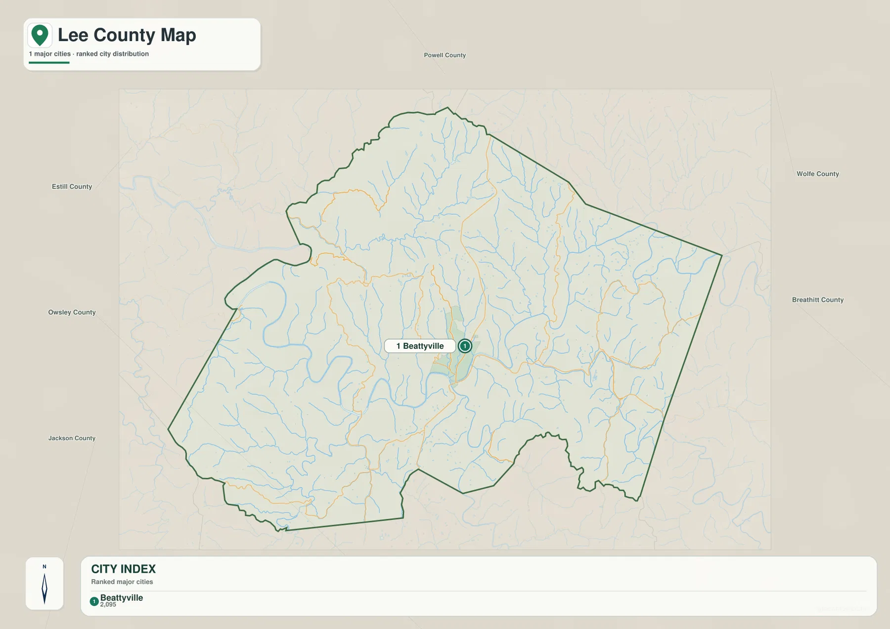
The city map deliberately removes much of the road labeling and gives Beattyville a single prominent marker. Its City Index lists Beattyville as the principal city, which makes the map useful when a reader needs the county seat without the visual clutter of every route and local name. The marker falls slightly east of the county’s geometric center, close to the river corridors that dominate the middle of Lee County. Small communities still matter in the broader county, but this view is designed around the clearest urban reference point.
County names around the outside provide another layer of useful context. Powell is shown to the north, Wolfe and Breathitt to the east and northeast, Owsley and Jackson to the west and southwest, with Estill on the western side as well. This makes the city map especially helpful for someone who knows eastern Kentucky by county names but has never looked closely at Lee. From Beattyville, the county extends well beyond the town into a broad mountain area cut by drainage valleys.
The city view should not be read as a full population ranking or a complete list of every settled place. Current population figures are better checked through the latest Census data. Its strength is simpler: it answers where Beattyville is, how much of the county lies around it, and which neighboring counties sit in each direction. Paired with the detailed county map, it lets a reader move from a clean location reference to the more complex road network without losing orientation.
The Kentucky River begins among closely spaced mountain valleys
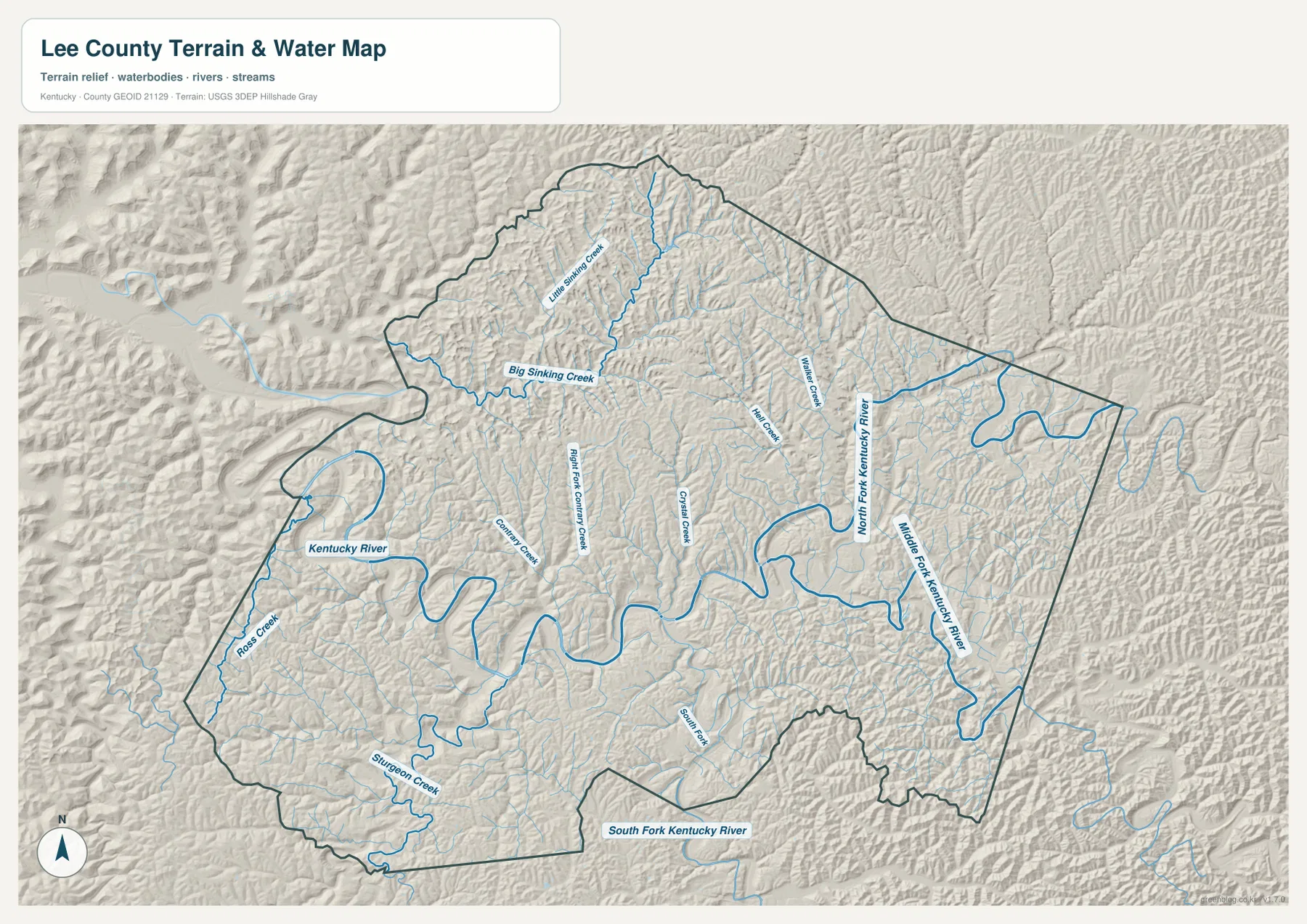
Water is the strongest organizing feature in the terrain map. Beattyville is known as the place where the North Fork and South Fork come together to form the Kentucky River, a fact emphasized by the city’s official website. On the supplied map, the North Fork Kentucky River approaches from the northeast, the South Fork Kentucky River is labeled to the south, and the Middle Fork Kentucky River appears on the eastern side. The resulting river corridor bends across the county in a series of broad loops rather than following a straight valley.
Named tributaries reveal even more about the interior. Big Sinking Creek and Little Sinking Creek drain the northwestern part of the county, Walker Creek appears in the northeast, and Hell Creek and Crystal Creek are labeled closer to the center. Ross Creek and Sturgeon Creek are visible in the west and southwest. These streams occupy narrow low ground between repeated ridges, which is why the water map looks like a branching network laid over strongly textured relief.
The western Kentucky River is particularly useful for seeing how the landscape controls the channel. The river doubles back several times within a short distance, and surrounding slopes rise quickly from the valley floor. Roads in the county often use the same low corridors, so comparing the water map with the county-road map explains many of the turns that would otherwise seem arbitrary. A route that looks indirect on a flat screen may actually be following the only practical valley around a ridge.
This map is a geographic reference, not a flood, navigation, or legal-water-boundary product. It does not provide flood-depth estimates, channel conditions, property limits, or guarantees about access. Its value is in showing how major forks, named creeks, and terrain fit together at county scale. For flood safety or regulatory questions, readers should use the appropriate government hazard and property records instead of relying on this general map.
Low river corridors surrounded by higher northern and interior ridges
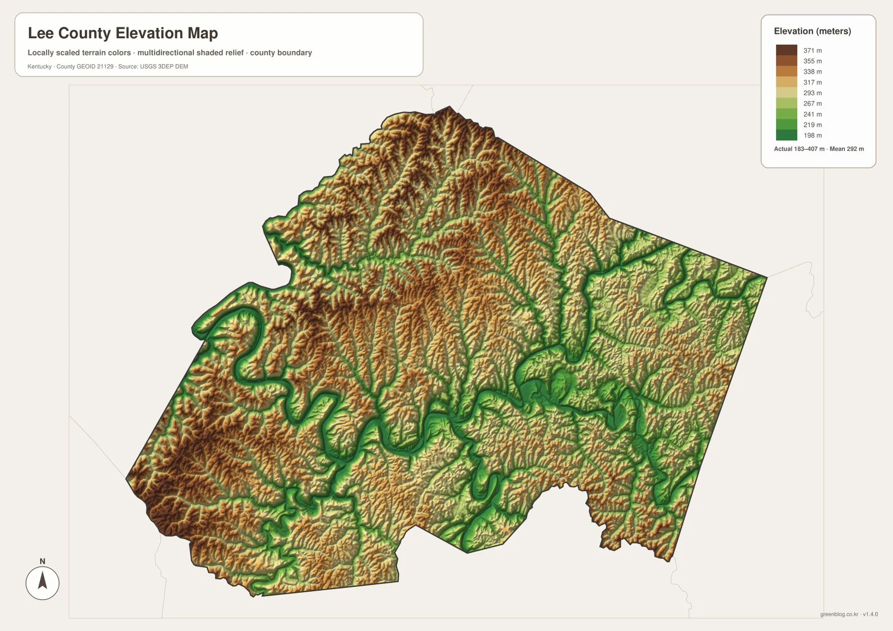
The elevation map gives a county-wide range of about 183 to 407 meters, with a mean near 292 meters. The lowest colors trace the Kentucky River and its tributary valleys in narrow green bands, while higher brown and tan ridges fill much of the land between them. Because the relief changes repeatedly over short distances, Lee County appears almost corrugated from above. This is the clearest map for understanding why the water network and road network share so many of the same corridors.
Northern Lee County contains an especially dense concentration of higher ridges. Long narrow crests run between thin drainage valleys, and a similar pattern continues across the northeastern side. Around Beattyville, lower ground widens where several river branches come together. The western river loops and the southern drainage corridors are also outlined by lower colors. The result is a landscape where a broad low basin is uncommon; instead, low ground forms winding ribbons through the mountains.
The county government’s published range of 610 to 1,367 feet is broadly consistent with the relief shown here, although source methods and map resolution are not identical. The elevation surface should therefore be used for regional comparison, not as a survey-grade value for a house lot, construction site, or engineering project. A person who needs an exact point elevation should consult detailed elevation data or a professional survey rather than reading a single color from this generalized county view.
Looking back to the water map helps turn the elevation colors into recognizable geography. Big Sinking Creek, Walker Creek, and the Kentucky River occupy low corridors, while ridges rise on both sides. That relationship also explains why settlements and roads tend to cluster near valley floors. Lee County’s physical geography is not simply “mountainous”; it is a repeating combination of stream valleys, narrow ridgelines, and a few larger river junctions that create room for towns and transportation.
How the county’s history still matches the modern landscape
Lee County’s official history says the county was formed in 1870 from portions of Breathitt, Estill, Owsley, and Wolfe counties. Proctor served as the first county seat before Beattyville became the administrative center. That history makes more sense when seen against the terrain: river access and narrow valley corridors were important for moving people and goods through a region where crossing ridge after ridge was difficult. Modern roads have changed transportation, but they still work within the same physical setting.
The county also notes that much of its western area is now part of the Daniel Boone National Forest. The maps in this package are not land-ownership or national-forest boundary maps, so they should not be used to decide whether a particular tract lies inside federal land. Even so, the sparse road pattern, rugged western relief, and abundance of streams help explain the forested mountain setting described by the county. That broader context is useful when reading the west side of the maps, where named places are fewer and terrain is prominent.
Beattyville’s official site calls the community the heart of the Kentucky River and describes a mountain town surrounded by waterways, cliffs, and forest. The supplied maps give those words a physical shape. Beattyville occupies lower ground at the river forks, while higher terrain rises quickly in nearly every direction. Instead of treating the town, river, and mountains as separate facts, the map set shows how all three are tied together in one compact landscape.
Using each map for a different Lee County question
Use the county map first when the question is about Beattyville, the county boundary, numbered roads, or nearby communities. The city map is better when a clean location marker is more useful than road detail. For waterways, river forks, and the relationship between creeks and ridges, the terrain-and-water view contains the clearest information. The elevation map is the strongest choice for comparing low valleys with higher ridge country and for explaining why routes and streams occupy winding corridors.
A school report or local presentation does not need every layer on one page. A transportation topic can begin with Routes 11 and 52 on the county map, while a natural-geography topic may pair the water map with the elevation view. Someone who only needs to locate the county seat can use the simplified city map. Keeping the views separate prevents labels and symbols from competing with one another and makes the page easier to read at normal print size.
The four views describe the same county, but they answer different questions. Together they show a consistent pattern: Beattyville lies in lower ground where major river branches meet, roads follow valleys away from town, tributaries divide the interior into many narrow ridges, and higher elevations dominate much of the northern and outer county. Reading that pattern across the maps is more informative than treating any single image as a complete description of Lee County.
Frequently Asked Questions
Why is Beattyville the best starting point on a Lee County map?
Beattyville is the county seat and sits where major river forks come together to form the Kentucky River. Routes 11 and 52 also pass through or near the town, so the same location connects government, transportation, and hydrography. Finding Beattyville first makes it easier to understand the surrounding road network, the river junction, and the lower valley shown on the elevation map.
What does the elevation map reveal about travel across Lee County?
The map shows roughly 183 to 407 meters of elevation and a dense pattern of high ridges divided by low stream valleys. Roads often follow those lower corridors instead of crossing ridges directly, which helps explain the many bends visible on the county map. The elevation surface is intended for broad comparison, however, and should not be treated as a survey measurement for a specific site.
Can the water map be used to determine flood zones or property boundaries?
No. The terrain-and-water map shows the general locations of the Kentucky River, its forks, and named tributaries, but it is not a flood hazard, parcel, legal boundary, or navigation product. Flood questions require official hazard mapping, and ownership or parcel questions require county records. This map is intended for geographic orientation, learning, and printable reference.
Map File Information
The archive contains the original high-resolution JPG versions of the Lee County boundary map, city map, terrain-and-water map, and elevation map. Each source image is 3638×2572 pixels, making the files suitable for printing, classroom material, and offline reference.
- File Type: four JPG files in a ZIP archive
Related Maps
Sources and references
County formation, the Eastern Coal Field setting, the county seat, and the published elevation range are described by the official Lee County website and its county history page. Beattyville’s location at the meeting of the North Fork and South Fork and its relationship to the Kentucky River are described by the official City of Beattyville website.
For underlying geographic reference, readers can consult the U.S. Census Bureau TIGER/Line files for boundaries and roads, USGS National Hydrography for water features, and the USGS 3D Elevation Program for elevation data. These authoritative sources are useful when more detailed data is needed beyond the simplified map views on this page.
Green Map creates custom-edited map images using open geographic data sources such as geoBoundaries, Natural Earth, OpenStreetMap, and government open data. These maps are edited visual materials, not raw data files, and are provided for education, documents, presentations, and graphic reference.