Roscommon County sits in the north-central Lower Peninsula of Michigan, where large inland lakes, forested uplands, small streams, and widely spaced communities shape the map. Roscommon appears near the north-central part of the county, Houghton Lake and Prudenville lie farther southwest, and St. Helen is set apart on the eastern side. US-127 and I-75 provide separate north-south corridors, while M-55 and M-18 connect communities across the interior. The high-resolution A3 JPG maps used on this page are also available together in one downloadable ZIP file.
The county is easiest to understand by using its lakes as landmarks. Houghton Lake covers a broad area in the western half, and Higgins Lake occupies another large basin to the north. Around those lakes, the terrain is generally lower and smoother than the rugged ground shown in the southeast and parts of the south. Headwater streams in the northeast belong to the Au Sable system, while other creeks and river reaches point toward different drainage areas. The road network threads between these lakes, wetlands, and low valleys rather than following one simple grid.
Table of Contents
Roscommon, Houghton Lake, and St. Helen sit on different travel corridors
On the general county map, Roscommon is positioned near the northern middle of the county with convenient access to I-75 and M-18. I-75 enters from the north, passes east of Roscommon, and bends southeast toward the eastern side of the county. US-127 follows a separate route along the western side, passing west of Higgins Lake and Houghton Lake. M-55 runs east-west along the southern side of Houghton Lake and continues toward St. Helen, creating an important cross-county connection between the lake area and the eastern interior.
Houghton Lake and Prudenville are close to the southern and southeastern shore of the large lake. M-18 runs north from this area toward Roscommon, so it links the lake community with the northern county seat area without requiring a trip all the way to US-127 or I-75. St. Helen lies farther east beside Lake St Helen and is reached from the M-55 corridor. This separation is important when reading the map: Roscommon County does not have one continuous urban strip, and the major communities are arranged around different roads and bodies of water.
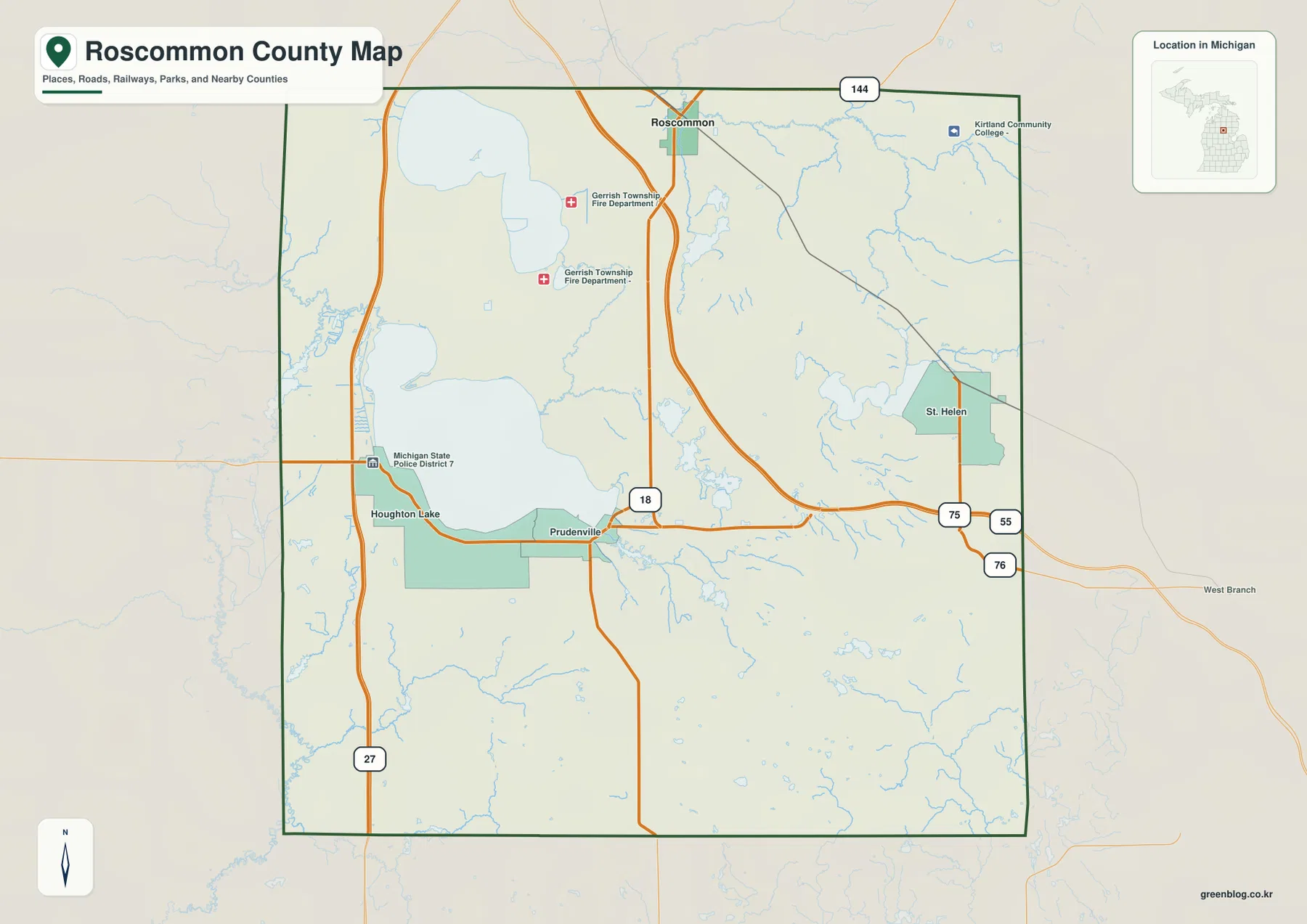
The western edge of the map faces Missaukee and Clare counties, while Ogemaw County is on the east. Crawford County lies to the north, and additional central Michigan counties appear around the southern and southeastern sides. Those neighboring labels help orient the county within the Lower Peninsula, especially because US-127 and I-75 continue beyond the local boundary. The map is useful for regional orientation, but it is not a live navigation product and does not show temporary closures, construction, winter road conditions, or traffic delays.
Roscommon functions as a northern reference point, the Houghton Lake area forms a separate concentration around the county’s largest visible lake, and St. Helen anchors the eastern side. That pattern explains why different highways matter in different parts of the county. A traveler coming from the west may reach the lake area first on US-127, while an I-75 trip naturally approaches Roscommon or the eastern side. M-55 then becomes the practical east-west link across the southern half of the county.
The city index highlights Roscommon rather than every community
The city-index map marks Roscommon as the number-one ranked place and shows a value of 1,118 in the index at the bottom. That figure should be treated as the value used by the map’s city-index dataset, not as a claim about a current population estimate. Unlike some county city maps, this version does not draw mileage lines from a hub to several other communities. Its purpose is much simpler: it singles out Roscommon and shows where that reference point sits inside the county.
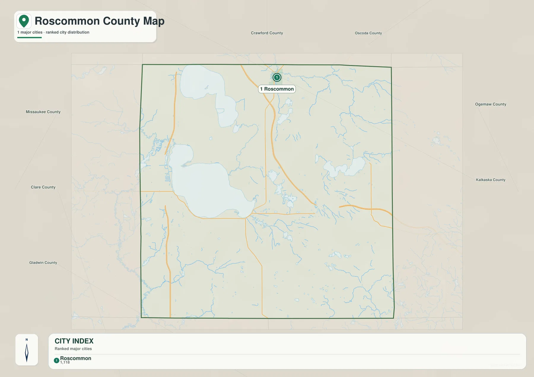
Houghton Lake, Prudenville, and St. Helen still appear on the general map even though they are not listed in this ranked index. The difference reflects the purpose of the two products rather than the importance of the communities themselves. Use the general county map when you need named settlements and highways together. Use the index map when you want a cleaner view of Roscommon’s position and the surrounding county directions without the visual weight of every local label.
Labels outside the boundary include Crawford, Oscoda, Ogemaw, Kalkaska, Missaukee, Clare, and Gladwin counties. They provide regional orientation but do not indicate driving distance or travel time. Some of those counties meet Roscommon County directly, while others are shown farther around the map frame for context. For route planning, current directions from a navigation service remain the better source because the county index is designed for geographic reference rather than turn-by-turn travel.
Houghton Lake and Higgins Lake dominate the water map
Houghton Lake is the largest feature on the water map, filling much of the west-central part of Roscommon County. Higgins Lake lies to the north, with Marl Lake tucked near its southern end. The size of these two lakes makes them natural reference points for the surrounding road network and smaller waterways. Between and around them are numerous small ponds, wetlands, and creek channels that are much easier to see on the terrain-and-water layer than on the general road map.
Lake St Helen forms another clear water feature on the eastern side. Near the middle of the county, Little Mud Lake and Backus Lake Flooding stand out among a cluster of smaller waters. West Twin Lake appears farther southeast, while Sugar River and Townline Creek reach the southern edge. Wolf Creek is labeled in the southwest, and the Muskegon River name appears near the western side. These features show that the county is not drained by one river system alone.
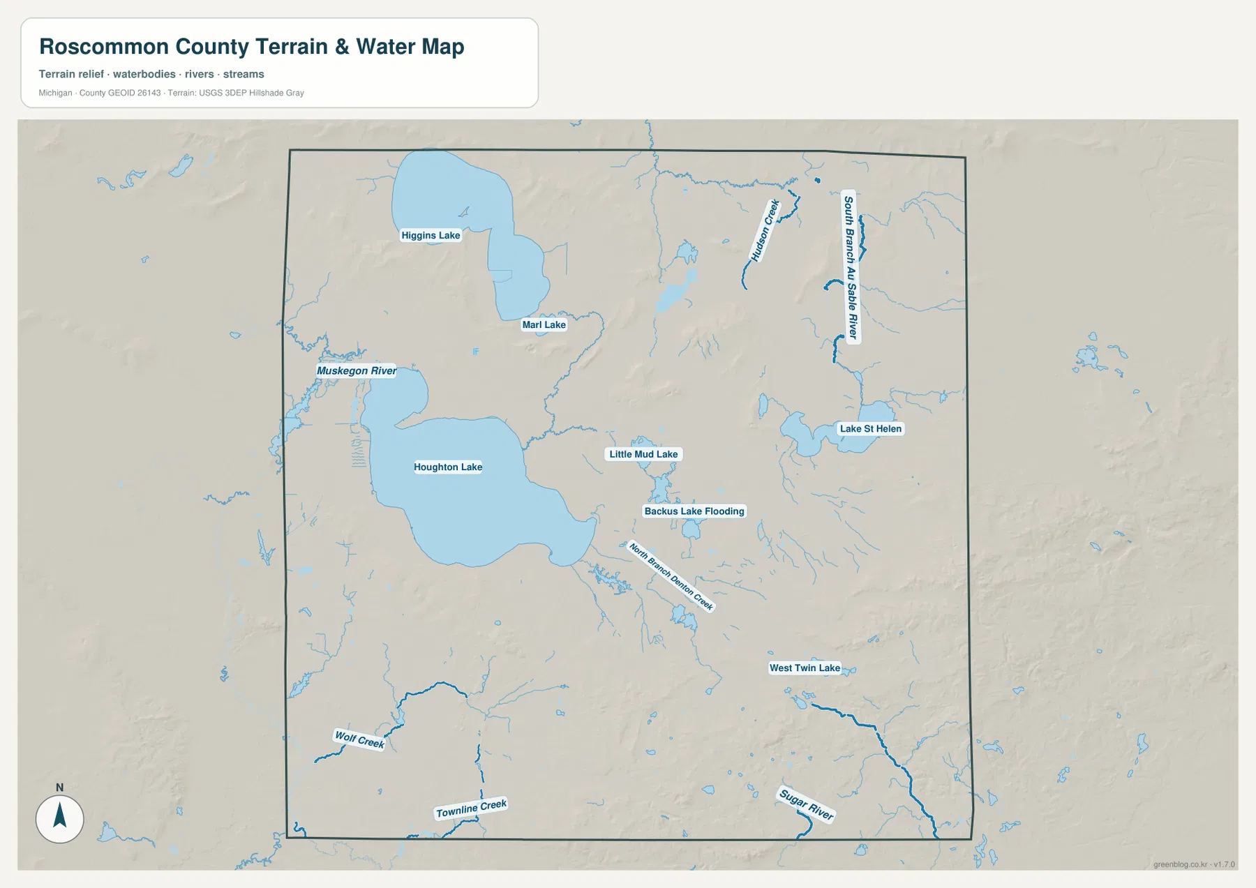
In the northeast, Hudson Creek and the South Branch Au Sable River are labeled among a dense group of headwater channels. North Branch Denton Creek appears farther south of the Houghton Lake area. Looking at those streams together with the lake basins helps explain why some parts of the county have many winding drainage lines while other areas are dominated by open water. The map is especially useful for understanding relative location before checking more detailed hydrology or recreation information.
The Michigan Department of Natural Resources publishes fisheries and access information for Higgins Lake, including access associated with South Higgins Lake State Park and Marl Lake. That official material is a good companion to this map because it adds site-level details that a countywide graphic cannot show. The map itself should not be used to determine water depth, navigable channels, boating restrictions, fishing regulations, flood risk, or private shoreline access.
Roscommon County also contains state wildlife lands associated with the Houghton Lake area. Michigan DNR lists the Houghton Lake State Wildlife Research Area as well as several flooding wildlife management areas in the county. Those managed lands reinforce how closely water, wetlands, and wildlife habitat are connected here, but rules can change by season and activity. Anyone planning hunting, fishing, boating, or field access should use the current DNR pages in addition to a general county map.
Higher ridges rise south and southeast of the major lake basins
The elevation map changes the impression created by the broad lake basins. Areas around Houghton Lake and Higgins Lake are shown mostly in greens and lighter mid-range colors, indicating comparatively lower and smoother ground. The southeast contains a much larger block of orange and brown relief, and several prominent ridges also appear in the south-central part of the county. Shorter ridges surround parts of the northern lake country, so the county is not uniformly flat even where the lakes dominate the landscape.
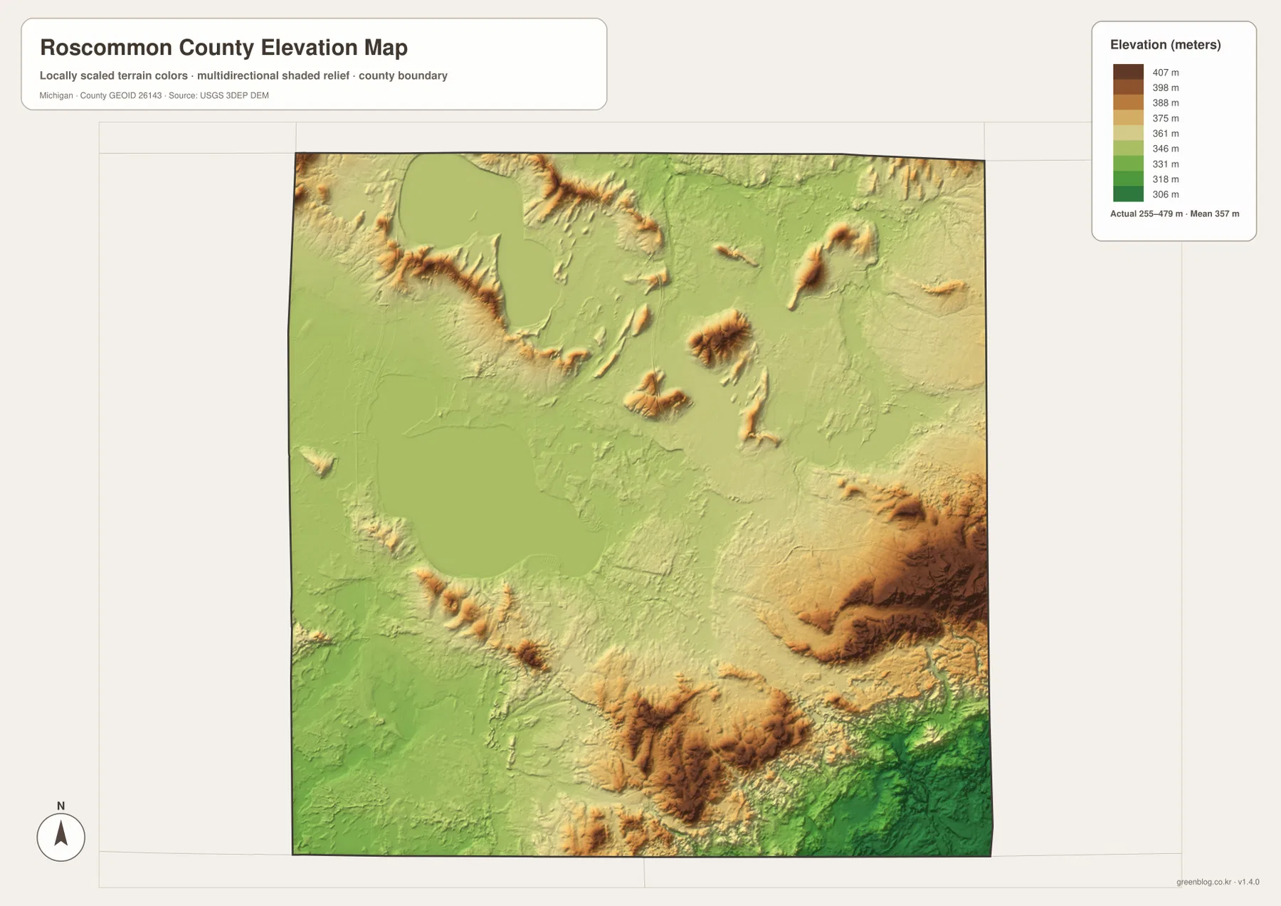
The legend displays representative color steps from about 306 to 407 meters, while the note on the map reports an actual surface range of roughly 255 to 479 meters and a mean near 357 meters. Those two sets of numbers serve different purposes. The color ramp is designed to make countywide differences visible, while the actual range summarizes the elevation surface used to create the relief. Neither should be substituted for a surveyed elevation at a house, road, trail, or parcel.
The most rugged-looking terrain occupies the southeast, where high ridges are cut by lower valleys that continue toward the county boundary. Another strong cluster of hills appears south of the central lake area, and smaller isolated rises occur farther north. Comparing these forms with the water map shows why streams often follow narrow low corridors between higher slopes. The relationship is visible without requiring technical terrain analysis: darker low valleys and raised brown ridges simply provide a clear visual contrast.
Because Houghton Lake and Higgins Lake are so prominent, it is easy to picture Roscommon County as mostly level lake country. The relief map shows a more varied landscape. The west and lake basins are generally gentler, while the south and southeast include stronger elevation changes that may matter for hiking, cycling, forestry, or site visits. Anyone who needs exact grades, drainage design data, or engineering elevations should move from this overview to detailed USGS elevation products and field measurements.
Choose the map by the question you need to answer
The general county map is the best starting point for roads and named communities. It shows how US-127 serves the western lake area, how I-75 passes near Roscommon and bends toward the east, and how M-55 links Houghton Lake with St. Helen. If you are trying to place a campground, lake community, or road junction within the county, this version provides the most useful combination of names and transportation features.
For hydrology, the water map adds far more detail. Houghton Lake, Higgins Lake, Marl Lake, Lake St Helen, Backus Lake Flooding, Au Sable headwaters, the Muskegon River label, and smaller creeks can be compared on one page. The elevation layer is the better choice when the main question is terrain. It makes the lower lake basins and the higher southeastern ridges immediately apparent, which can help explain why water and roads follow certain valleys.
The city-index map has a narrower role. It highlights Roscommon and offers regional context with surrounding counties, but it does not attempt to list every settlement or draw road distances. That is why it should be used beside the general map rather than as a replacement for it. Switching between the four views is more useful than expecting one map to answer every question about communities, water, roads, and relief.
Roscommon County’s official website provides current county departments, services, and online mapping resources. Michigan DNR adds fisheries, access, recreation, and wildlife-management information for the lake country. Those sources are useful when a visit or activity requires current rules or facility details. The maps on this page are best treated as a readable county overview that helps you decide what to investigate in greater detail.
Download package and practical uses
The download package contains the general county map, city-index map, terrain-and-water map, and elevation map as high-resolution JPG files. Each image is 2572 × 3638 pixels in A3 portrait format. They can be enlarged on screen, printed for personal reference, used in classroom material, or placed in presentations where a countywide view is more useful than an interactive map.
For printing, keeping the original aspect ratio will preserve labels and boundary lines better than stretching the image to fill an unrelated page size. If you crop a map for a slide or worksheet, retain enough surrounding context that roads and water features are not mistaken for exact parcel boundaries. These graphics are reference maps, not substitutes for legal surveys, flood determinations, marine navigation, engineering plans, or live road information.
Frequently Asked Questions
Why does the city-index map show only Roscommon?
The city-index version uses Roscommon as its single ranked reference place. It does not mean Houghton Lake, Prudenville, or St. Helen are absent from the county. Those communities are shown on the general map, which is the better choice when you need a broader set of settlement and highway labels.
Which map is best for comparing Houghton Lake and Higgins Lake with nearby streams?
The terrain-and-water map is the most useful option. It shows both large lakes along with Marl Lake, Lake St Helen, the Muskegon River label, Hudson Creek, South Branch Au Sable River, North Branch Denton Creek, and many smaller channels. Use the general map beside it if you also need roads and community names.
Can the 255–479 meter elevation range be used as a site elevation?
No. That range summarizes the countywide elevation surface used for the relief map. It is useful for comparing the lower lake basins with higher ridges in the south and southeast, but it is not precise enough for parcel, construction, drainage, road-design, or surveying decisions. Detailed USGS data or a site survey should be used for those purposes.
Map File Information
Download the Roscommon County general, city-index, water, and elevation maps together as high-resolution JPG files in one ZIP.
- Included Files: county map, city-index map, terrain-and-water map, elevation map
- File Type: ZIP containing four JPG images
Related Maps
Sources and references
- Roscommon County, Michigan — county government, services, and online mapping resources
- Michigan Department of Natural Resources – Central Lake Michigan Management Unit — Higgins Lake fisheries and access information
- Michigan DNR – State Wildlife/Game Areas — Houghton Lake wildlife management areas
- U.S. Census Bureau – TIGER/Line Shapefiles — county boundaries and base geography
- U.S. Geological Survey – National Hydrography — river, stream, and lake data
- U.S. Geological Survey – 3D Elevation Program — elevation and terrain data
Green Map creates custom-edited map images using open geographic data sources such as geoBoundaries, Natural Earth, OpenStreetMap, and government open data. These maps are edited visual materials, not raw data files, and are provided for education, documents, presentations, and graphic reference.