Presque Isle County occupies a long stretch of northeastern Michigan’s Lower Peninsula where the Lake Huron shoreline, small inland communities, river valleys, and rolling uplands all meet within one county. Rogers City sits near the central coast, Onaway anchors the western side, Posen lies farther south, and US-23 follows the lakeshore while M-68, M-65, M-211, and M-33 organize inland travel. Four downloadable A3 JPG maps accompany the article, with separate views for roads and places, city connections, water features, and elevation.
The county’s shape is immediately distinctive. Its northern and eastern edge bends along Lake Huron, while the western boundary stays much straighter and the southern edge cuts across a broad inland landscape. Rogers City is close to the shore, Onaway lies near the western boundary, and Posen occupies the southern interior. Rivers and small lakes are spread throughout the county, but the elevation map shows that the shoreline is generally lower than the pronounced hills in the southwest and south-central interior. Reading those features together explains why the road network and drainage do not follow one simple grid.
Table of Contents
Rogers City ties the Lake Huron road corridor to the inland routes
On the county map, Rogers City is easy to locate where the built-up area meets the Lake Huron shore and US-23. A courthouse callout also identifies the county’s administrative center there. US-23 follows the coast through the eastern part of the county, continuing toward Presque Isle Harbor to the southeast and toward the northern shoreline in the opposite direction. M-68 turns inland west of Rogers City and runs toward Onaway, making it the most obvious east-west route across the middle of the map.
Onaway sits close to the western county line where M-68 meets north-south routes. M-211 is shown just west of the city center, and M-33 continues south from the same general area. Farther east, Posen is positioned on M-65 in the southern interior. Millersburg appears between Onaway and Rogers City but away from the largest highway corridor, while Presque Isle Harbor occupies a separate coastal setting east of Posen. These locations make it clear that the county is not organized around a single urban strip.
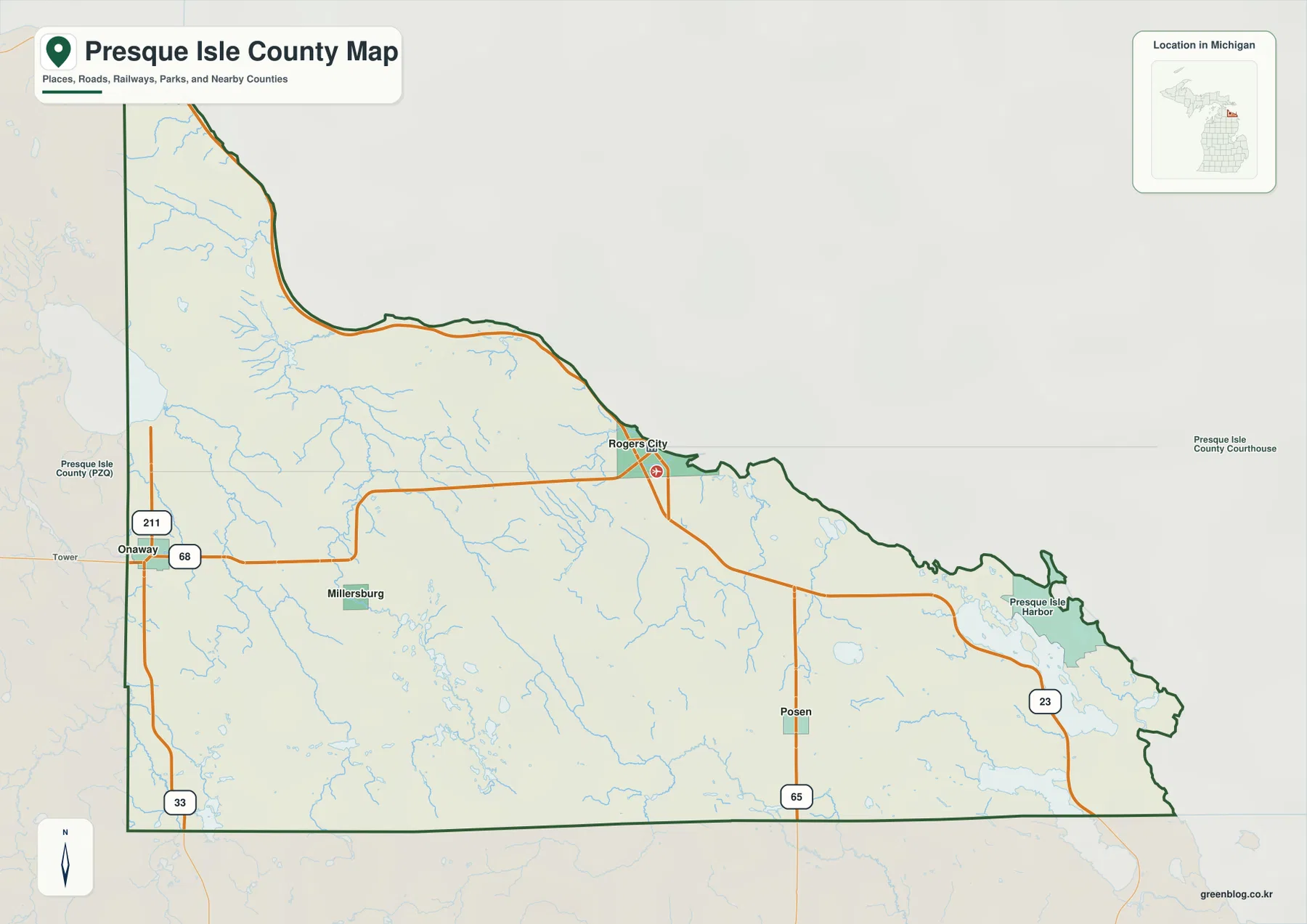
The border labels also help with regional orientation. Cheboygan County lies to the west and northwest, Montmorency County is southwest of Presque Isle County, and Alpena County continues south. Onaway’s location near the western edge becomes much clearer when those neighboring counties are visible, while Posen and Presque Isle Harbor belong more naturally to the southeastern side of the county. The map is useful for understanding these relationships, but it should not be treated as a live navigation product with construction, closure, or traffic information.
For a quick countywide overview, this is the strongest of the four maps because it combines settlements, major roads, shoreline shape, nearby counties, and many smaller streams. Rogers City works as the clearest coastal reference point, Onaway explains the western road junction, and Posen makes the M-65 corridor easier to follow. The map also shows how far inland the county extends from Lake Huron, which matters when comparing the low coast with the higher terrain farther southwest.
The city connection map measures straight-line distance from Rogers City
The city connection map uses Rogers City as the hub and draws lines toward Onaway, Posen, and Millersburg. Its lower panel lists Rogers City at 2,878, Onaway at 674, Posen at 345, and Millersburg at 137, while also giving direct distances from the hub: about 20 miles to Onaway, 12 miles to Posen, and 13 miles to Millersburg. The numeric city values are best treated as the map’s own comparison figures rather than assumed to be current population estimates, and the mileage is explicitly straight-line distance.
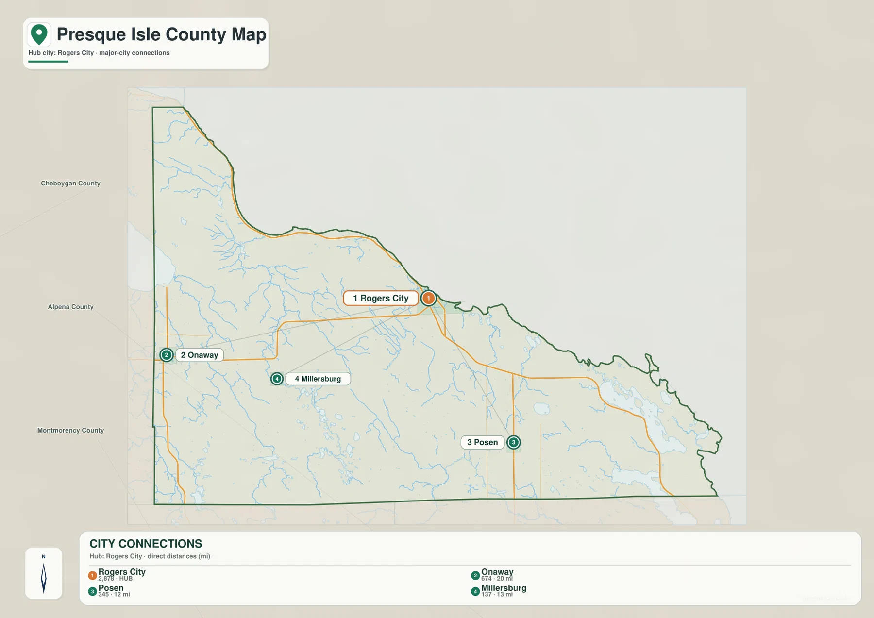
Driving distance can be longer because the road network does not follow those straight lines. Rogers City and Onaway are linked most naturally through the M-68 corridor, while a trip toward Posen depends on the relationship between US-23, M-65, and local roads. Millersburg is not placed directly on the largest highway line shown on the county map, so the exact driving route varies with the starting point. The connection graphic is therefore best for comparing direction and relative separation, not for estimating travel time.
The index is also selective. Presque Isle Harbor appears on the county map but is not part of the four-place ranking, and smaller communities are omitted as well. That does not mean those places are absent from the county. It means the city connection graphic was designed as a simplified comparison centered on Rogers City. Use the county map when the goal is to see more place names and road context, then switch to a current routing service for actual travel planning.
Ocqueoc River, inland lakes, and coastal streams divide the county into several drainage areas
The terrain-and-water map makes the county’s hydrology much easier to follow. Lake Huron fills the northern and eastern side, while inland streams approach the shoreline from several directions. Black Lake occupies a large area near the northwest edge, and the Black River, Rainy River, and Little Rainy River are labeled in the western portion of the county. East of that group, the Ocqueoc River forms one of the most prominent river systems shown on the map, with multiple tributaries joining it before the river reaches the coastal side of the county.
Farther east, the Trout River and Swan River each follow their own route toward Lake Huron, and the Little Trout River appears nearer the coast. The southern interior contains the North Branch Thunder Bay River, which runs across the lower part of the map rather than toward the same mouth as the northern streams. Quinn Creek and numerous unnamed tributaries add a finer network between the larger labels. This arrangement is important because Presque Isle County cannot be described as one continuous drainage basin; several river systems share the same county.
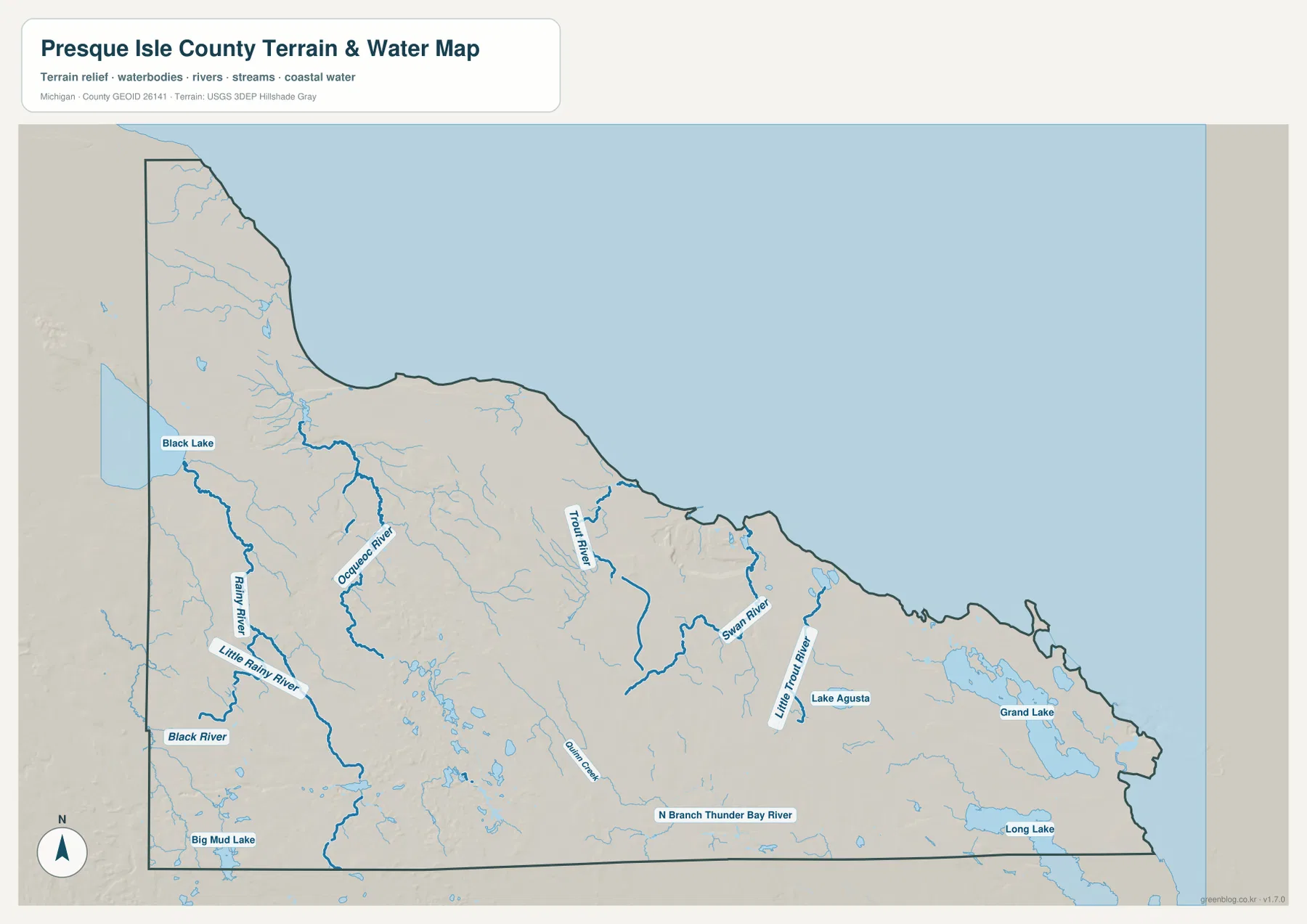
Grand Lake is the largest labeled inland lake on the eastern side of the map, with Lake Augusta nearby and Long Lake stretching along the southeastern edge. Big Mud Lake appears in the southwest, while many smaller water bodies are scattered through the interior. The concentration of lakes near the eastern shoreline adds another layer to the county’s geography: some places are connected more strongly to the coastal lake district, while others are organized around river valleys and upland drainage farther west.
The Ocqueoc River also connects to one of the county’s better-known recreation areas. Michigan Department of Natural Resources materials list Ocqueoc Falls State Forest Campground in Presque Isle County, and a 2026 DNR release highlighted the Ocqueoc Falls Trailhead and Scenic Overlook. Those references are useful for current recreation information, but the countywide water map does not show detailed access roads, water levels, fishing rules, trail conditions, or campground availability.
This map should not be used as a flood-hazard map, wetland boundary, navigation chart, or property-access document. It is a regional hydrography reference that helps place rivers, lakes, and shoreline water in relation to one another. Boating, fishing, flood planning, shoreline ownership, and site-specific access require more detailed official information. For those purposes, use the broad map for orientation and then move to the relevant agency or local map.
Low Lake Huron terrain rises sharply into the southwest and south-central interior
The elevation map shows a strong contrast between the coast and the county’s inland hills. Dark green tones follow much of the Lake Huron shoreline, including the areas near Rogers City and Presque Isle Harbor, which indicates relatively low ground. Narrow low corridors also extend inland along stream valleys. Those lower routes line up well with the river network on the water map, especially where streams descend toward the shoreline.
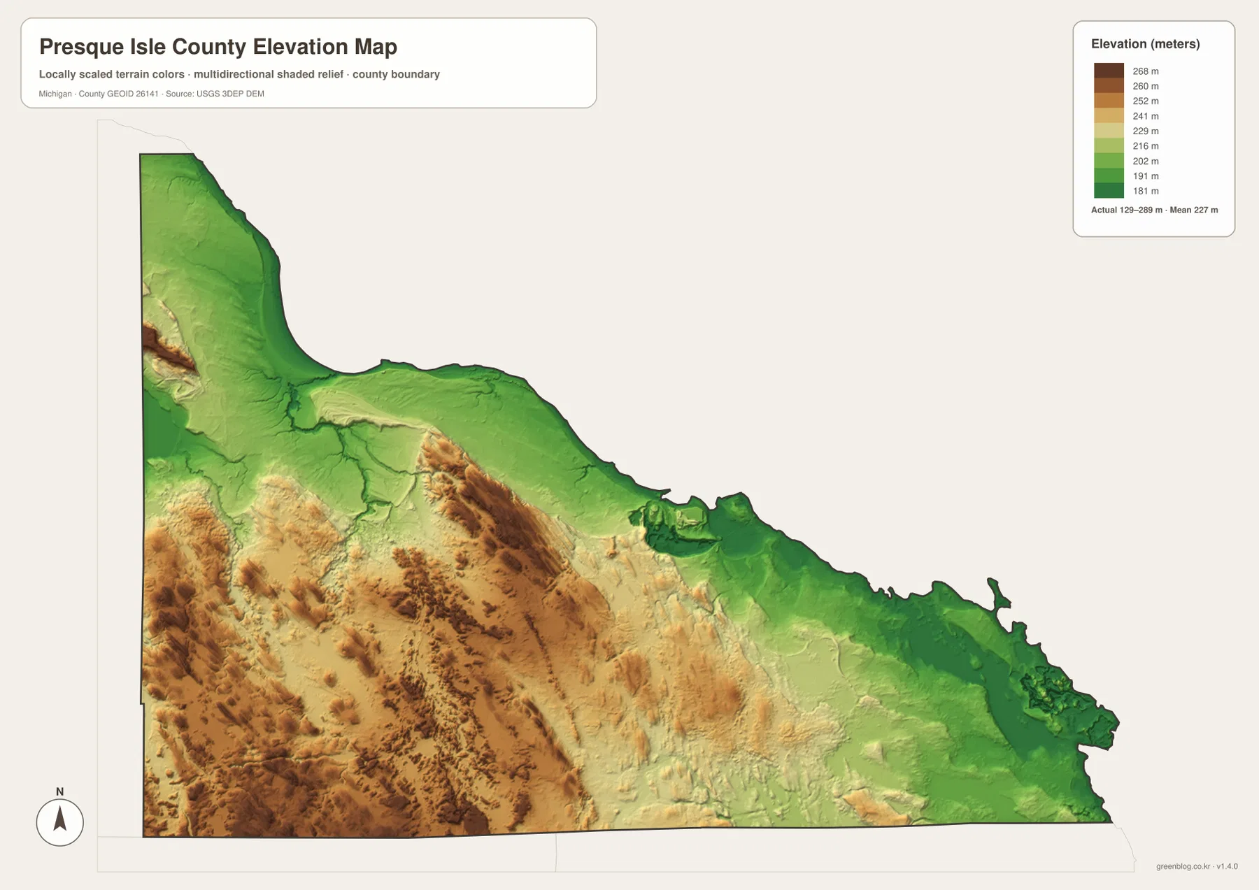
The southwest is very different. Brown and tan tones form a large block of higher terrain near the western and southern edges, and another prominent ridge extends through the south-central part of the county. Smaller valleys cut through those uplands, creating a broken surface rather than one continuous plateau. The result is a county where the western interior can feel topographically separate from the low shoreline even though the straight-line distance is not especially large.
The legend uses representative color steps from about 181 to 268 meters, while the map separately reports an actual surface range of approximately 129 to 289 meters and a mean near 227 meters. Those values serve different purposes. The color legend groups elevation into readable classes, whereas the actual range summarizes the lowest and highest values in the underlying generalized surface. The highest legend color therefore should not be read as the exact maximum elevation.
Comparing relief with drainage helps explain the county’s river patterns. Streams leave higher inland ground through narrow valleys and descend toward Lake Huron or into the southern Thunder Bay system. Grand Lake and Long Lake sit closer to the lower eastern side, while the most extensive high ground lies farther west and south. The map is effective for regional terrain comparison, but it is not survey-grade elevation data and should not be used for construction, drainage design, road grading, or parcel-level measurements.
US-23, the Ocqueoc River, and inland ridges call for different map views
Start with the county map when the main question is where Rogers City, Onaway, Posen, Millersburg, US-23, M-68, M-65, and the county boundaries are located. It provides the clearest road-and-place context and works well for general orientation before a trip or presentation. The city connection map is more specialized: it quickly compares three direct distances from Rogers City, but it is not intended to replace road mileage or a complete community index.
Use the water map when the focus shifts to Black Lake, the Ocqueoc River, Trout River, Swan River, Grand Lake, Long Lake, or the network of small tributaries that reaches Lake Huron. The elevation map adds the physical setting by showing why the coast and river valleys are lower than the southwest and south-central uplands. Moving between those two maps is especially useful because the drainage network makes more sense once the surrounding relief is visible.
The official Presque Isle County website is the better source for current county departments and local administrative information, while Michigan DNR pages should be used for current state-forest recreation details such as Ocqueoc Falls. The maps on this page are countywide reference products, so current road closures, campground status, fishing regulations, water access, and site rules should always come from the responsible agency.
The download archive contains the original JPG versions of all four maps shown here: the county map, city connection map, terrain-and-water map, and elevation map. Each image is 2572 × 3638 pixels in an A3 portrait layout, which provides enough resolution for screen enlargement, classroom material, presentations, and personal reference printing. They are not substitutes for legal boundary records, flood products, navigation charts, engineering data, or professional surveys.
Frequently Asked Questions
Are the 20, 12, and 13 mile labels on the city connection map driving distances?
No. The map identifies Rogers City as the hub and gives direct distances of about 20 miles to Onaway, 12 miles to Posen, and 13 miles to Millersburg. Actual driving distance depends on M-68, M-65, local roads, and the exact start and end points, so a current routing service is the right source for travel time and road mileage.
Which map is best for comparing the Ocqueoc River with Grand Lake and Long Lake?
The terrain-and-water map is the clearest choice because it shows the Ocqueoc, Trout, Swan, Black, and southern Thunder Bay drainage systems together with Grand Lake, Long Lake, Lake Augusta, Black Lake, and the Lake Huron shoreline. Pair it with the county map when you also need nearby roads and communities.
Can the 129-289 meter elevation range be used for site-level measurements?
No. That range summarizes the generalized countywide elevation surface and is useful for comparing the low shoreline with higher inland hills. Construction, drainage, road design, parcel work, and other precise applications require more detailed elevation data and, when appropriate, professional field surveying.
Map File Information
Download the four high-resolution Presque Isle County JPG maps used on this page in one ZIP archive.
- Included Files: county map, city connection map, water map, elevation map
- File Type: ZIP containing four JPG files
Related Maps
Sources and References
- Presque Isle County, Michigan — official county departments and local government information
- Michigan Department of Natural Resources – State Forest Campgrounds — official recreation information including Ocqueoc Falls State Forest Campground
- Michigan DNR – Natural Resources Trust Fund 50-year record — official reference to the Ocqueoc Falls Trailhead and Scenic Overlook
- U.S. Census Bureau – TIGER/Line Shapefiles — county boundaries and base geography
- U.S. Geological Survey – National Hydrography — rivers, streams, and lakes
- U.S. Geological Survey – 3D Elevation Program — elevation and terrain reference data
Green Map creates custom-edited map images using open geographic data sources such as geoBoundaries, Natural Earth, OpenStreetMap, and government open data. These maps are edited visual materials, not raw data files, and are provided for education, documents, presentations, and graphic reference.