Download the high-resolution A3 JPG ZIP for Franklin County, Tennessee directly from this page; it includes the county, city, water, and elevation maps shown below. Winchester is the main central reference, Decherd and Estill Springs sit to the north, Cowan lies to the east, and Huntland is well to the southwest. Tims Ford Lake dominates the western water pattern, while the Sewanee–Monteagle side rises sharply into much higher terrain.
The Franklin County Tennessee Map is easiest to understand as a contrast between a lower central-western area and a much higher southeastern edge. Winchester, Tims Ford Lake, and the Elk River side occupy the lower half of the elevation range, while Cowan provides a transition toward Sewanee and Monteagle. Looking at those relationships first makes the roads, streams, and settlement labels easier to interpret without turning the article into a list of map layers.
Table of Contents
Winchester anchors a chain of towns across the county
The city map labels Winchester at 9,799 residents, Decherd at 2,976, Estill Springs at 2,695, Cowan at 1,934, and Huntland at 1,532. The numbers show the relative size of the towns, but their spacing is more useful for orientation. Decherd and Estill Springs sit close to Winchester on the northern side, Cowan is roughly six miles east, and Huntland is about thirteen miles to the southwest.
Winchester and Decherd appear almost as a central pair on the map, while Estill Springs provides a northern reference near the Elk River and Woods Reservoir side. Cowan is the key eastern town before the terrain climbs toward Sewanee and Monteagle. Huntland marks the southwestern part of the county, where the surface is lower and less sharply dissected than the southeast.
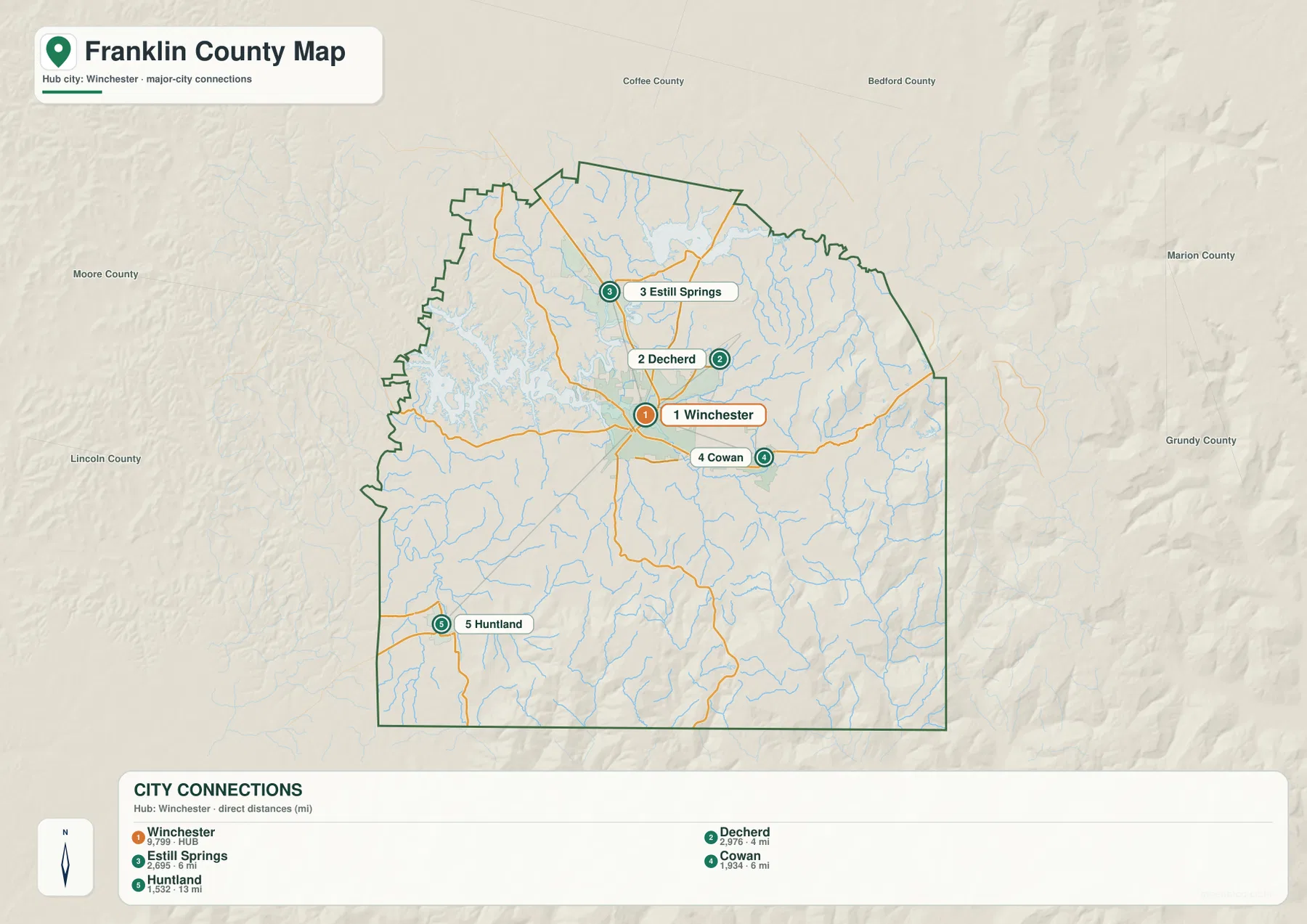
Neighboring county labels help frame the outline. Coffee and Bedford counties are north of Franklin County, Marion and Grundy counties are to the east, and Moore and Lincoln counties lie to the west. The southern county line meets Alabama. These outside references make it clear that Franklin County spans a broad transition from lower lake-and-river country to the higher southeastern upland.
Roads converge on Winchester, then climb toward Sewanee
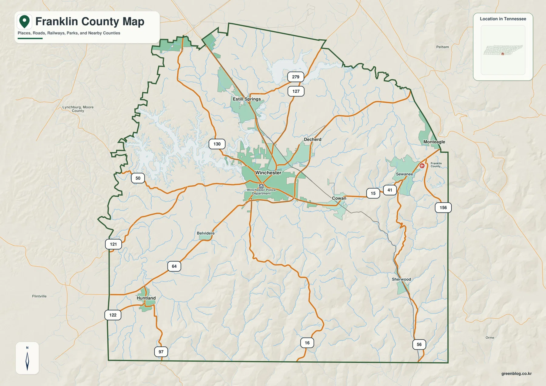
The base map shows a dense set of routes around Winchester. Routes 127 and 279 lead north toward Estill Springs, while 130 reaches northwest toward the Tims Ford Lake side. Routes 50 and 121 cross the west, and 64, 122, and 97 provide southwestern connections. Route 16 runs south from the central part of the county.
East of Winchester, Cowan sits near Routes 15 and 41 on the way toward Sewanee. Farther east, Routes 156 and 56 follow the county’s higher edge, and Monteagle appears near the northeastern boundary. The terrain changes quickly in this direction, so the road map becomes more informative when compared with the elevation image: the eastern routes cross or follow a much more rugged surface than roads near Winchester or Huntland.
Sherwood in the southeast provides another useful reference for that terrain shift. Roads approaching the southeastern border wind among narrow valleys and ridges, while the southwestern side around Huntland is broader and less steep. For route notes, Winchester and Cowan form a useful central-east pair, and adding Sewanee or Huntland makes the county’s two very different directions easy to distinguish.
Tims Ford Lake and Elk River define the western and northern water pattern
Tims Ford Lake is the dominant water feature in western Franklin County. Its branching shoreline reaches into many valleys and gives the western side a very different shape from the higher east. To the north, Elk River connects with the Woods Reservoir area and provides another major water reference near Estill Springs.
The northern water map also labels Duncan Lake and Holland Pond. Farther south and east, smaller features such as Long Pond, Lake O’Donnell, Day Lake, and Lakeview Lake show that water is not confined to Tims Ford Lake. These smaller lakes are useful reference points when the larger river and reservoir names are too far from a road or town being discussed.
Several creeks help explain the terrain away from the reservoirs. Boiling Fork Creek crosses the central-eastern area, while Beans Creek, Dry Creek, and Taylor Creek run through the southern half. Crow Creek follows a pronounced southeastern valley, matching the lower green corridor visible among the high ridges on the elevation map.
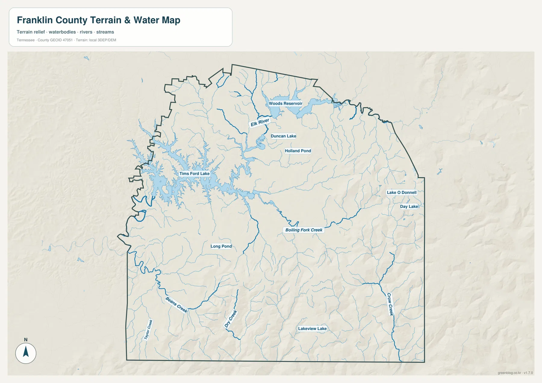
This water layer is intended for geographic reference rather than current water conditions. It does not establish flood limits, boating access, shoreline ownership, or a precise water level for a specific date. Its value here is showing where rivers, reservoirs, and creeks sit in relation to Winchester, roads, and the surrounding terrain.
A 190–621 m range separates the Winchester lowlands from the Sewanee heights
The elevation map shows an actual range of about 190 to 621 meters, with a mean near 357 meters. Winchester, Decherd, and much of the Tims Ford Lake side appear in lower green shades. Moving east through Cowan toward Sewanee and Monteagle, the map shifts rapidly through yellow and brown tones as the terrain rises.
The strongest relief appears in the southeast. High ridges around Sewanee are cut by narrow valleys, and the Sherwood side contains another dense pattern of steep slopes and drainage corridors. Crow Creek follows one of the lower valleys through this rugged area, helping connect the water map with the elevation pattern.
The southern-central and southwestern portions are more moderate. Rolling ground extends south of Winchester, but the terrain does not reach the same height or ruggedness as the southeastern edge. Around Huntland, broader lower surfaces make the contrast with Sewanee especially obvious when both sides of the county are viewed on the same scale.
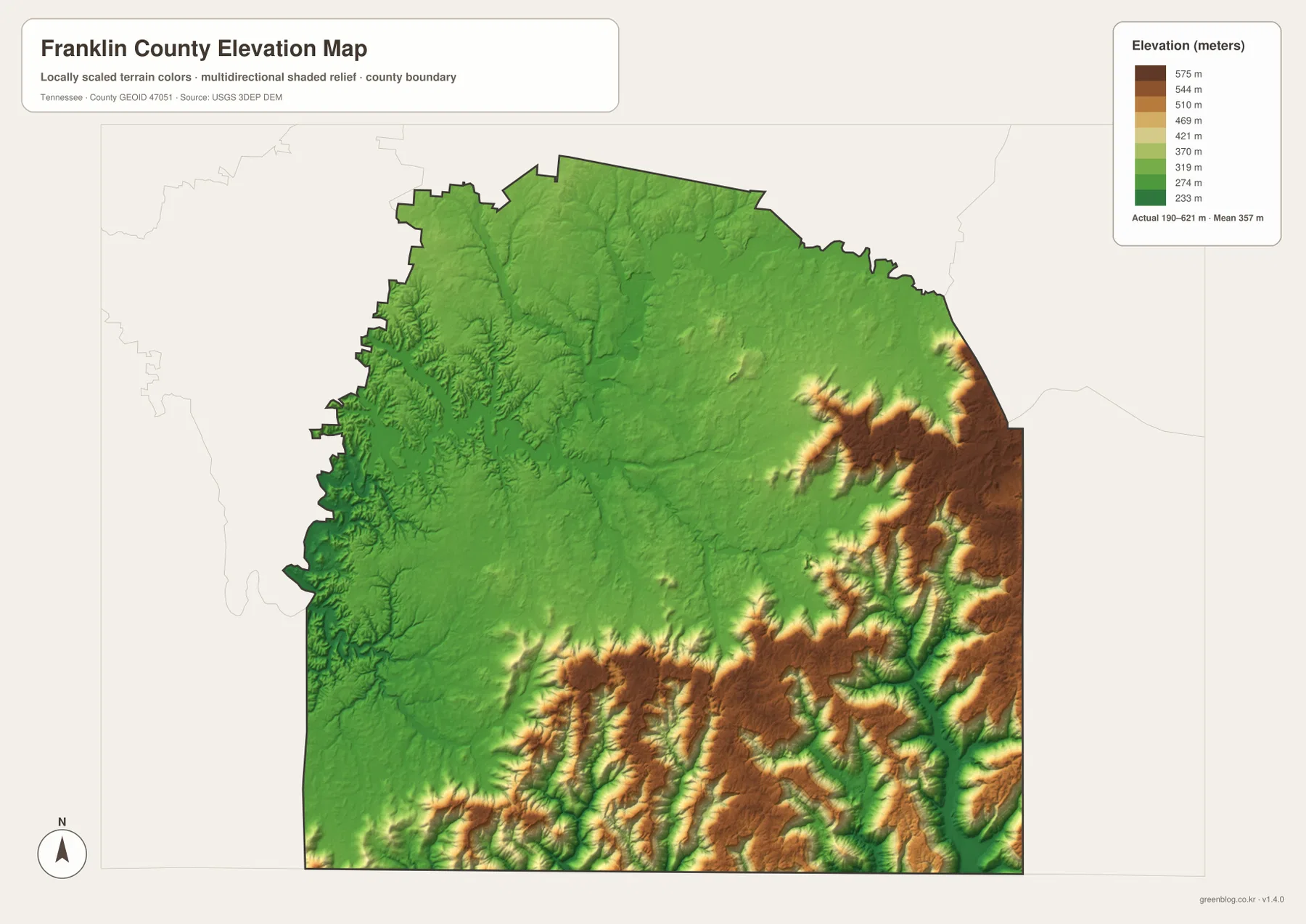
The colors are designed for relative comparison across the county. They are not a parcel survey or an exact building-elevation record, but they clearly show why eastbound roads become more winding and why southeastern streams occupy narrow valleys between high ridges.
Connecting towns, water, roads, and relief
The city map establishes the Winchester–Decherd–Estill Springs cluster and the more distant positions of Cowan and Huntland. The water map then adds Tims Ford Lake and Elk River as large western and northern references. The elevation layer explains the final major contrast: Cowan leads toward a much higher southeastern landscape around Sewanee and Monteagle.
A westbound line from Winchester approaches the complex shoreline of Tims Ford Lake and relatively lower rolling terrain. An eastbound line reaches Cowan and then climbs into steep ridges and narrow drainage valleys. Those two directions look different on every map, which is why Franklin County is easier to understand as a transition between lake-and-river country and the higher southeastern upland.
Use the county map when roads, boundaries, and town labels matter most. The city map is cleaner for comparing Winchester, Decherd, Estill Springs, Cowan, and Huntland. Choose the water map for Tims Ford Lake, Elk River, or Woods Reservoir, and use the elevation map when the Winchester-to-Sewanee height change is the main subject.
Choosing and downloading the A3 JPG maps
The WebP images in the article are convenient for quick viewing, while the JPG originals in the ZIP are better for printing, enlargement, and offline reference. For a road-focused page, mark only the towns and routes needed on the county map. Keep lake, river, and creek notes on the water map so labels do not cover the road network.
The elevation image is especially useful in color because the difference between the lower Winchester–Tims Ford area and the high Sewanee side is carried by the terrain colors. If Tims Ford Lake is the main subject, the larger water-map JPG provides more room to follow the branching shoreline and nearby creeks than the web preview.
The downloadable ZIP contains the high-resolution A3 JPG originals for the county, city, water, and elevation maps shown on this page. They can be used for classroom comparison, presentations, route notes, regional study, or personal offline storage when a larger image is more useful than the browser preview.
Frequently Asked Questions
How do Winchester and Sewanee differ on the map?
Winchester lies in the lower central part of the county, while Sewanee is east of Cowan on much higher terrain. The elevation layer shows a rapid rise toward Sewanee, and the base map shows the eastbound road connection through Cowan.
Where are Tims Ford Lake and Elk River?
Tims Ford Lake dominates western Franklin County. Elk River is a major northern water feature and connects with the Woods Reservoir side near Estill Springs. The water map is the clearest layer for comparing both with Winchester.
Sources and reference data
County boundaries and general location can be compared with U.S. Census Bureau TIGER/Line. Local county reference material is available from the Tennessee State Library and Archives Franklin County fact sheet, and road placement can be checked against the Tennessee Department of Transportation Franklin County map.
For more detailed hydrography, see USGS National Hydrography. Elevation data can be checked against the USGS 3D Elevation Program. The geographic descriptions on this page are based on the towns, roads, water features, and elevation patterns visible in the supplied Franklin County maps.
Map File Information
Download the high-resolution A3 JPG originals for the Franklin County county, city, water, and elevation maps shown in this article.
- Included Files: County map, city map, water map, elevation map
- File Type: ZIP containing 4 JPG files
Related Maps
Green Map creates custom-edited map images using open geographic data sources such as geoBoundaries, Natural Earth, OpenStreetMap, and government open data. These maps are edited visual materials, not raw data files, and are provided for education, documents, presentations, and graphic reference.