Marshall County is centered on Plymouth, with Bremen and La Paz across the north, Bourbon to the east, and Argos and Culver in the southern half. You can download the high-resolution JPG ZIP directly from this page when you need larger place names, road shields, water labels, or terrain shading. This Marshall County Indiana Map page brings together the U.S. 31–U.S. 30 road framework, a six-place city index, Yellow River and Tippecanoe River, Lake Maxinkuckee and several smaller lakes, and an elevation surface ranging from about 214 to 274 meters.
Plymouth is the easiest place to use for orientation. U.S. 31 runs north-south past the city, U.S. 30 crosses the central county, and the northern U.S. 6 corridor links La Paz with Bremen. Farther south, State Road 10 ties the Argos–Bourbon side together. Marshall County’s official planning material identifies Plymouth as the county seat and largest city and describes U.S. 6 and U.S. 30 as major east-west routes, with U.S. 31 serving as the main north-south route.
The water and elevation views give the county a much more varied appearance than the road map alone. Yellow River bends through the Plymouth side of the county, while Tippecanoe River and several creeks organize the southeast. Lake Maxinkuckee is the strongest southwestern water landmark, joined by Lake of the Woods in the north and a cluster of smaller lakes west of Plymouth. The relief legend reports an actual range of about 214 to 274 meters and a mean of 245 meters, with low western ground contrasting with higher terrain through the north-central and eastern areas.
Table of Contents
Plymouth ties the U.S. 31 and U.S. 30 corridors to the northern and southern towns
Plymouth has the largest developed footprint on the general map. U.S. 31 passes along the eastern side of the city and U.S. 30 crosses nearby from west to east. Plymouth Medical Center is labeled within the urban area, and a rail line cuts through the county on a northwest-to-southeast path. Together, those features make Plymouth much easier to relocate than the smaller towns when switching between the four map views.
La Paz and Bremen provide the clearest northern references. La Paz sits close to the U.S. 31–U.S. 6 side, while Bremen lies farther east along U.S. 6. Lake of the Woods is south of that northern line and helps separate the two communities from Plymouth. Tyner appears farther west, where rail and small-water features are more prominent than a large developed footprint.
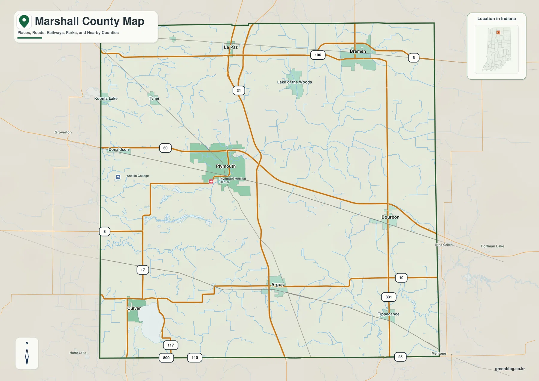
Argos and Culver divide the southern half into two very different landmarks. Argos lies near the U.S. 31 and State Road 10 side, while Culver occupies the southwest close to Lake Maxinkuckee. State Road 17 approaches the Culver area from the north. The combination of a town label, a large lake, and a changing road pattern makes the southwest visually distinct from the flatter-looking central road map.
Bourbon is the strongest town reference east of Plymouth, with State Road 10 farther south and the U.S. 30 corridor farther north. Tippecanoe sits closer to the southeastern edge near State Road 331. Because the eastern county contains fewer large urban labels, roads, streams, and the boundary itself become increasingly useful as location cues.
The city index shows Plymouth as the clear center, with five smaller towns spread around the county
The supplied city index highlights six places. Plymouth is printed at 10,664 and Bremen at 4,642. Argos and Bourbon are close in the index at 1,802 and 1,760, followed by Culver at 1,392 and La Paz at 476. These figures belong to the supplied map edition rather than a live demographic feed. Their strongest value here is spatial: Plymouth dominates the center, while the other five places divide the northern, eastern, and southern edges into easy reference points.
| Rank | Place | Value printed on map | Position |
|---|---|---|---|
| 1 | Plymouth | 10,664 | Central |
| 2 | Bremen | 4,642 | Northeast |
| 3 | Argos | 1,802 | South-central |
| 4 | Bourbon | 1,760 | East-central |
| 5 | Culver | 1,392 | Southwest |
| 6 | La Paz | 476 | North-central |
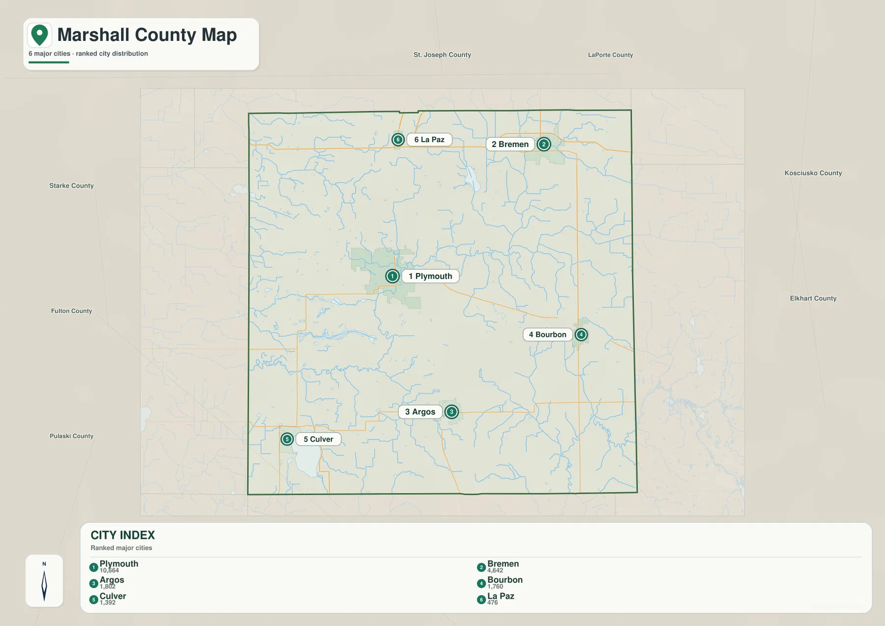
Plymouth and Bremen form useful central and northeastern anchors even though their printed values differ greatly. Argos and Bourbon look similar in index size but occupy different parts of the county, which makes them especially useful for separating the south from the east. Culver is easy to remember through Lake Maxinkuckee, and La Paz lines up with the northern U.S. 31 corridor.
The detailed general map also shows Tyner, Donaldson, and Tippecanoe, which are absent from the simplified index. Use the general map for those smaller places, rail lines, and route connections. Use the city index when you want a clean comparison of the six highlighted settlements. Current population work should rely on an up-to-date official source rather than the printed index values alone.
Yellow River bends west of Plymouth while Lake Maxinkuckee anchors the southwest
Yellow River is the strongest named river on the western half of the terrain-and-water map. It enters from the west and bends around the Plymouth side of the county, with numerous small tributaries and drainage lines surrounding the lowland. Pretty Lake, Lake Latonka, Mill Pond, Myers Lake, and Lawrence Lake form a compact group nearby, making the area west of Plymouth easy to recognize even without road labels.
Lake of the Woods provides a separate northern water landmark south of the La Paz–Bremen corridor. Elmer Seltenright M Ditch is labeled to its west, while the broader northern area contains fewer large named water bodies. On this map, the lake shape is more useful for orientation than trying to follow every small drainage line.
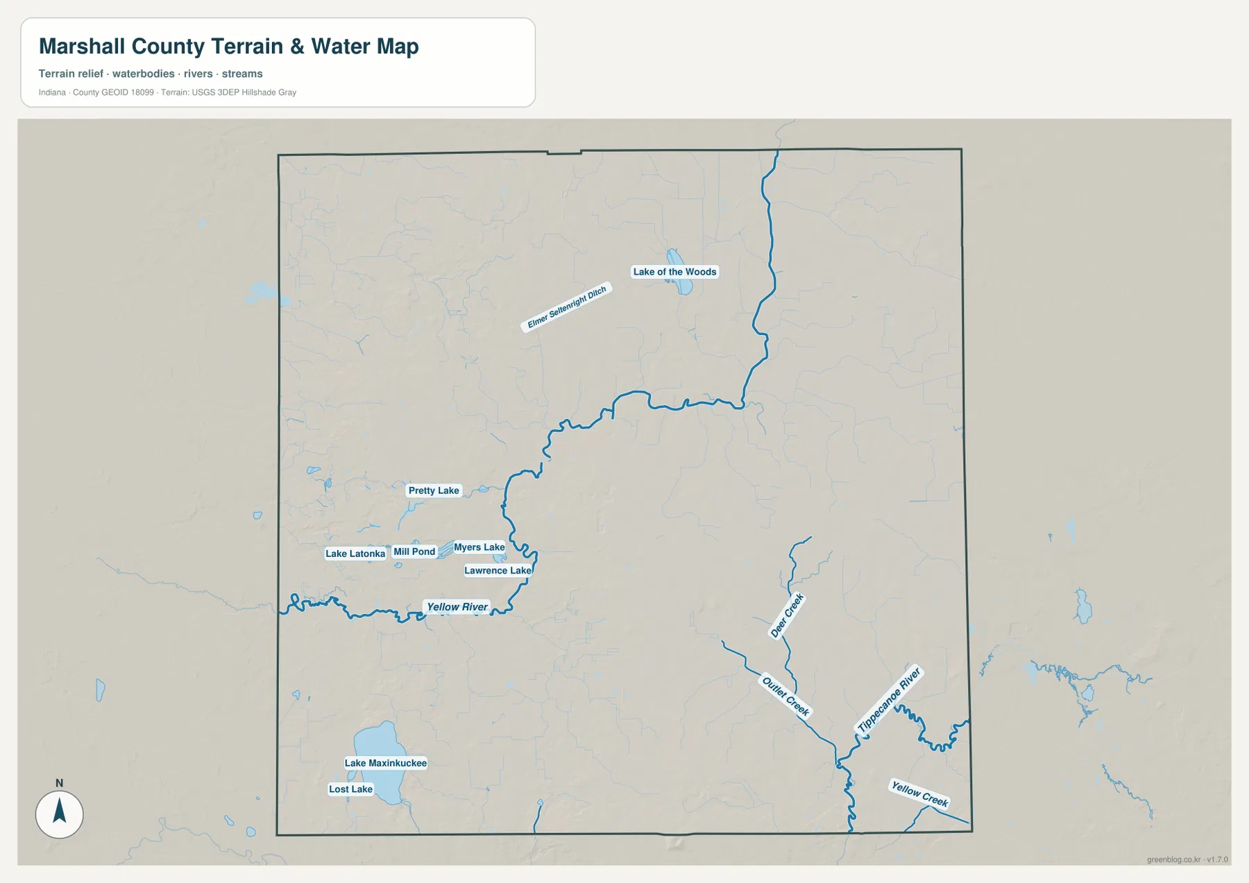
Lake Maxinkuckee is the most prominent water body in the southwest, with Lost Lake labeled just to the south. Indiana DNR’s lake association directory lists Lake Maxinkuckee in Marshall County at approximately 1,864 acres. For map reading, the important feature is its size and position beside Culver: the lake creates a distinctive southwestern landmark and a clear low basin on the elevation view.
Tippecanoe River provides the main southeastern water reference. Deer Creek approaches from the north, Quiller Creek from the west, and Yellow Creek lies close to the eastern boundary. This part of the county has relatively few large town labels, so the river bend and creek junctions are useful when matching the water view to the general map or elevation surface.
The terrain-and-water image is designed for geographic reference, not for flood-zone, current water-level, water-quality, navigation, or legal-boundary decisions. A blue line or water polygon does not establish parcel ownership or regulatory limits. Those questions require the current USGS, FEMA, Indiana DNR, or local source intended for that specific purpose.
The 214–274 m elevation surface separates western low ground from higher north-central and eastern terrain
The elevation legend gives an actual Marshall County range of about 214 to 274 meters and a mean of 245 meters. Green marks lower ground, while yellow, tan, and brown identify progressively higher terrain. The broadest low areas occupy the west and northwest, and Yellow River follows a lower corridor across the Plymouth side. Higher ground becomes much more prominent through the north-central and northeastern interior.
West of Plymouth, the Yellow River lowland and the small lake group create a complicated green-and-light-green surface. Moving north from that area, the terrain rises sharply into darker tan and brown ridges between the Plymouth and northern-town side of the county. The road map looks relatively open through those rural gaps, but the relief image shows a much stronger change in height.
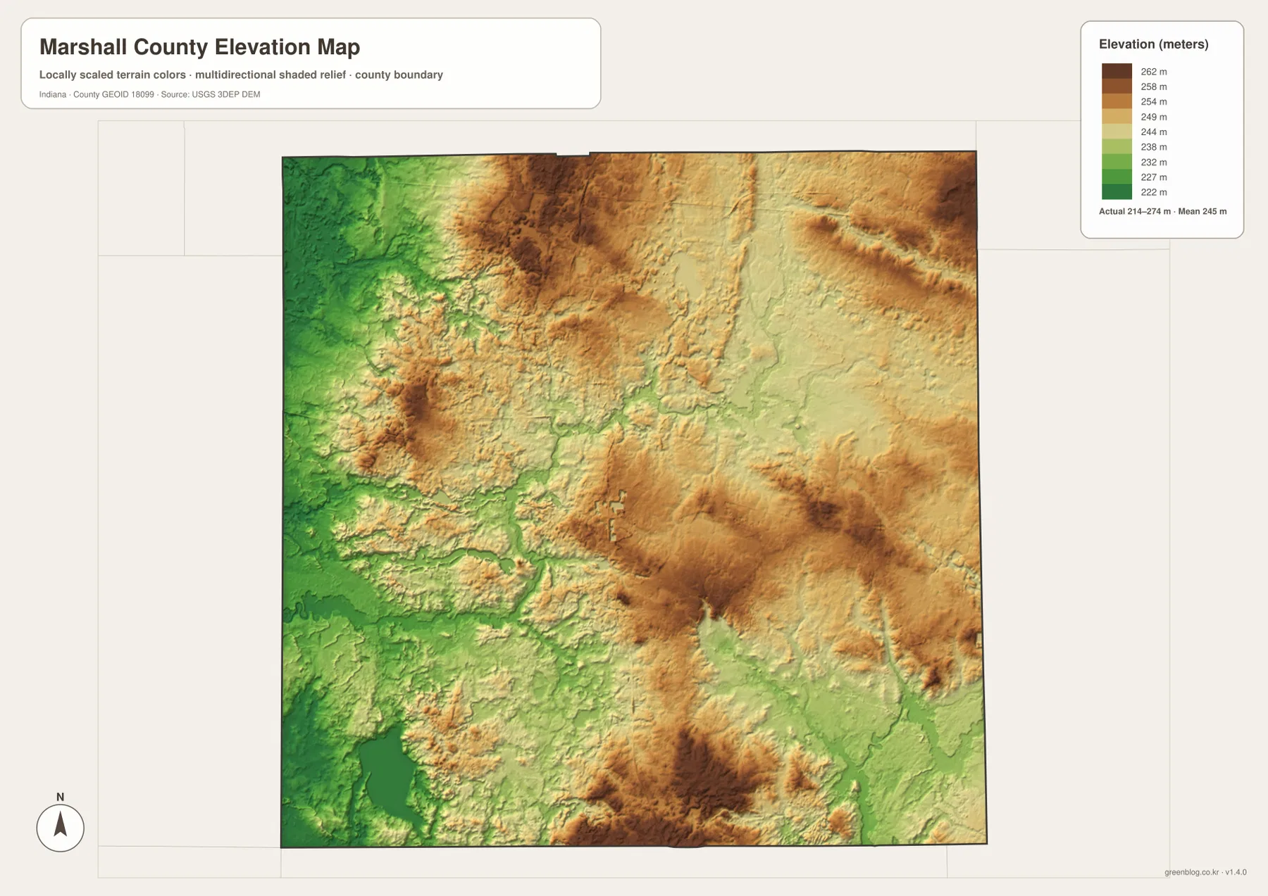
The east-central and southeastern portions remain moderately high overall, although Tippecanoe River, Deer Creek, and other drainage lines cut lower green corridors through that surface. Bourbon and Tippecanoe are useful town references when moving back to the general map. The result is not one flat eastern upland but a series of higher areas interrupted by stream valleys.
Lake Maxinkuckee occupies a clear southwestern low basin, and the land rises again around parts of its eastern and southern sides. A separate strong high area appears in the south-central county as well, showing that the Argos–Culver side is not uniformly flat. A practical county-scale reading is western river-and-lake lowlands, higher north-central hills, and moderately elevated eastern terrain cut by streams.
The 214–274 meter range is appropriate for broad terrain comparison, not for survey-grade work. A parcel corner, building pad, road grade, or drainage project needs original elevation data such as the USGS 3D Elevation Program or measurements from a qualified survey rather than this generalized county image.
Keep Plymouth fixed, then match the town pattern to Yellow River, Maxinkuckee, and the higher terrain
For roads and settlements, begin with Plymouth at the U.S. 31–U.S. 30 framework. Add La Paz and Bremen to the north, Argos and Culver to the south, and Bourbon to the east. The detailed general map is also the best place to find Tyner, Donaldson, Tippecanoe, and the rail corridors.
The city index works well when the goal is to compare only the six highlighted places. Plymouth clearly dominates the center, Bremen anchors the northeast, and Argos and Bourbon create south-versus-east reference points. Culver is linked visually to Lake Maxinkuckee, while La Paz helps locate the northern U.S. 31 side.
For physical geography, trace Yellow River and the small west-central lakes first, then move to Lake Maxinkuckee in the southwest and Tippecanoe River in the southeast. Switch to the elevation view at those same locations and the pattern becomes clear: water and river valleys occupy lower ground, while the north-central and eastern terrain rises into stronger hills.
The WebP images on this page are reduced previews. The Marshall County download contains four 3638×2572-pixel JPG originals covering the road-and-place map, city index, terrain-and-water view, and elevation surface. The larger originals are better for printing or reading small place, road, river, creek, and lake labels.
A useful comparison is to keep Plymouth fixed as the central reference. Find Bremen, Argos, and Culver on the general map, compare the highlighted places on the city index, move to the water view to trace Yellow River and Lake Maxinkuckee, and finish on the elevation image by comparing those low areas with the north-central hills. That sequence makes Marshall County’s settlement, water, and relief pattern much easier to understand.
Frequently Asked Questions
Which roads make Plymouth easiest to locate?
U.S. 31 passes the Plymouth side from north to south and U.S. 30 crosses the central county from west to east. U.S. 6 provides the main northern reference between La Paz and Bremen, while State Road 10 helps organize the Argos–Bourbon side farther south.
Which water features stand out most on the supplied map?
Yellow River is the clearest river near Plymouth, and Lake Maxinkuckee is the dominant southwestern lake beside Culver. Lake of the Woods marks the north, while Pretty Lake, Lake Latonka, Myers Lake, and Lawrence Lake form a smaller west-central cluster. Tippecanoe River is the strongest southeastern river reference.
Can the 214–274 m elevation range be used for exact site measurements?
No. The elevation image gives a county-wide range with a mean of 245 meters and is intended for comparing river and lake lowlands with the higher north-central and eastern terrain. For parcel-scale elevation work in Marshall County—including building pads, roadway grades, and drainage design—consult source elevation data or a qualified survey rather than this county map.
Map File Information
The Marshall County ZIP combines the general road-and-place map, six-place city index, terrain-and-water map, and elevation map as full-resolution JPG originals.
- File Type: ZIP containing four 3638×2572px JPG files
Related Maps
Sources and References
The article is based primarily on the supplied Marshall County map set and asset manifest. The following official sources provide county, road, lake, boundary, hydrography, and elevation context.
- Marshall County – History and Setting – official county material on Plymouth and the major U.S. 6, U.S. 30, and U.S. 31 corridors
- IN.gov Counties – Marshall County – official state county information including Plymouth and the county’s incorporated places
- Indiana DNR Lake Association Directory – official directory covering Lake Maxinkuckee, Lake of the Woods, and other Marshall County lakes
- U.S. Census Bureau TIGER/Line Shapefiles – boundary reference for Marshall County and its incorporated-place map framework
- USGS National Hydrography – hydrography reference for Yellow River, Tippecanoe River, creeks, and mapped lakes
- USGS 3D Elevation Program – source terrain data for checking detailed elevations beyond the county-scale relief image
Green Map creates custom-edited map images using open geographic data sources such as geoBoundaries, Natural Earth, OpenStreetMap, and government open data.
These maps are edited visual materials, not raw data files, and are provided for education, documents, presentations, and graphic reference.