You can download the Williamson County map set on this page as a ZIP containing four high-resolution A3 JPG files. Franklin is the central administrative and urban anchor, but the county is not organized around Franklin alone. Brentwood and Nolensville occupy the northeast and east, Thompson’s Station and Spring Hill extend the developed corridor southward, and Fairview sits apart in the western hills. The Harpeth River system and the county’s rolling relief help explain why these centers connect in different ways.
The terrain-and-water map follows Harpeth River along the north and identifies Little Harpeth River, West Harpeth River, and South Harpeth River in separate valleys. The elevation layer ranges from about 106 to 381 meters, with a mean near 239 meters. Lower ground is common through the central Franklin and river corridors, while higher ridges become more pronounced in the east, southeast, and parts of the west.
Table of Contents
Franklin is the hub, but Williamson County has several distinct urban centers
Franklin is the most obvious starting point on the general county map. The developed area around the city is broad, several major roads meet nearby, and local reference points such as Williamson Medical Center and O’More College of Design are marked within the urban area. Yet the county map also shows substantial separate development around Brentwood, Nolensville, Thompson’s Station, Spring Hill, and Fairview.
Those places occupy different parts of the county rather than forming one uniform ring. Brentwood lies northeast of Franklin and connects toward the Nashville side. Nolensville sits farther east, separated by rolling terrain and creek valleys. Thompson’s Station and Spring Hill extend the southern corridor, while Fairview is well to the west in a more strongly dissected landscape. Reading all of these labels together gives a much better sense of the county’s size and internal variety.
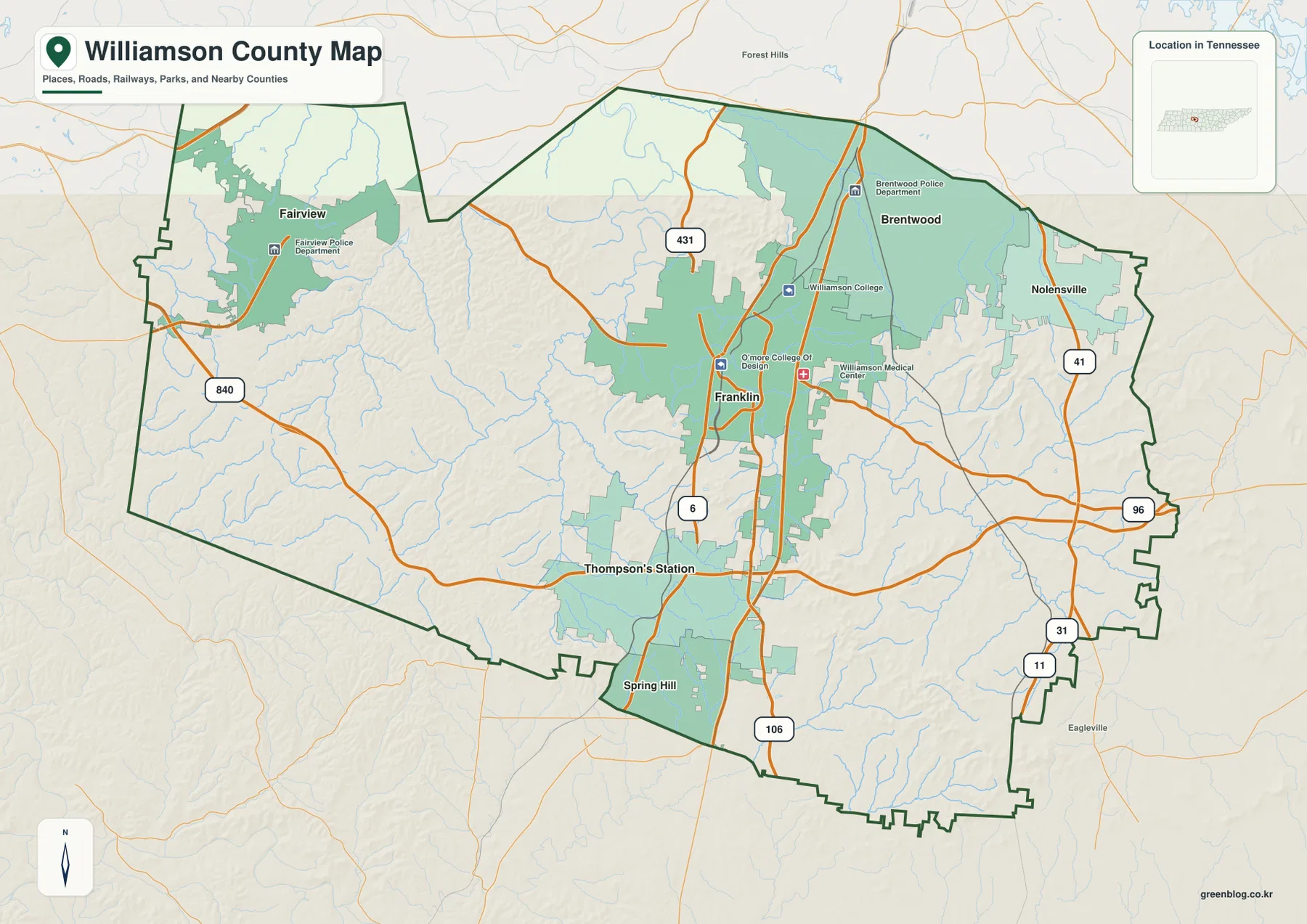
The road pattern reflects those different directions. Major routes connect Franklin north toward the Nashville area, south toward Thompson’s Station and Spring Hill, east toward Nolensville and Rutherford County, and west toward Fairview. The supplied regional labels place Davidson County to the north, Rutherford County to the east, Marshall and Maury counties to the south, and Hickman and Dickson counties toward the west.
Direct-distance lines show how far the major centers spread from Franklin
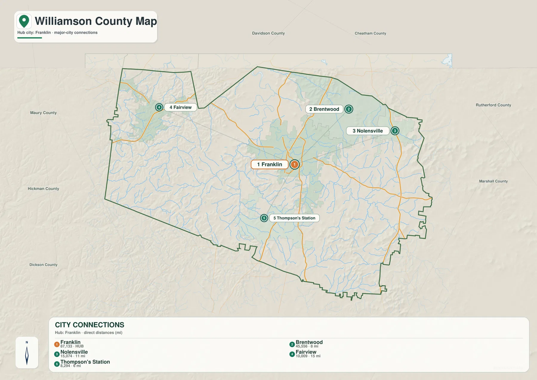
The city-connections map uses Franklin as the hub and ranks five places. Franklin is labeled at 87,133, Brentwood at 25,556, Nolensville at 15,074, Fairview at 10,009, and Thompson’s Station at 8,294. These figures are the values printed on the supplied city graphic and are intended for comparison within that map, not as a replacement for current municipal estimates or the countywide population.
The direct distances make the geography easy to compare. Thompson’s Station is shown about 6 miles from Franklin, Brentwood about 8 miles, Nolensville about 11 miles, and Fairview about 15 miles. Fairview’s longer westward separation is especially useful for understanding the county’s width, while Thompson’s Station illustrates how closely the southern development corridor approaches Franklin. Actual driving distance can be longer because roads must follow valleys, intersections, and stream crossings.
Countywide figures provide a different scale. The supplied reference material lists 247,726 residents in the 2020 census and a July 2025 estimate of 272,061. Williamson County contains about 582.9 square miles of land and 1.2 square miles of water. Dividing the 2020 population by the land area gives roughly 425 residents per square mile, but that average does not describe dense Franklin and Brentwood neighborhoods, the western hills, and rural southern areas equally.
Harpeth River branches occupy several different valleys across the county
Harpeth River is the dominant named watercourse on the supplied terrain-and-water map. The main river follows the northern part of the county, while Little Harpeth River descends through the northeast. South Harpeth River occupies a northwestern valley, and West Harpeth River winds through the central-southern interior. Together, these channels form a network rather than a single river line crossing the county in one direction.
Arrington Creek is labeled in the east and joins the broader drainage system, while Rutherford Creek follows a long valley in the southeast. The map also marks Clement Lake, Stephens Lake, Pine Hill Lake, Jackson Lake, Clovercroft Lake, Robinsons Lake, and Thompson Lake. These smaller waters help locate the lower spaces between hills and show why the drainage pattern is dense even though the county’s total mapped water area is relatively small.
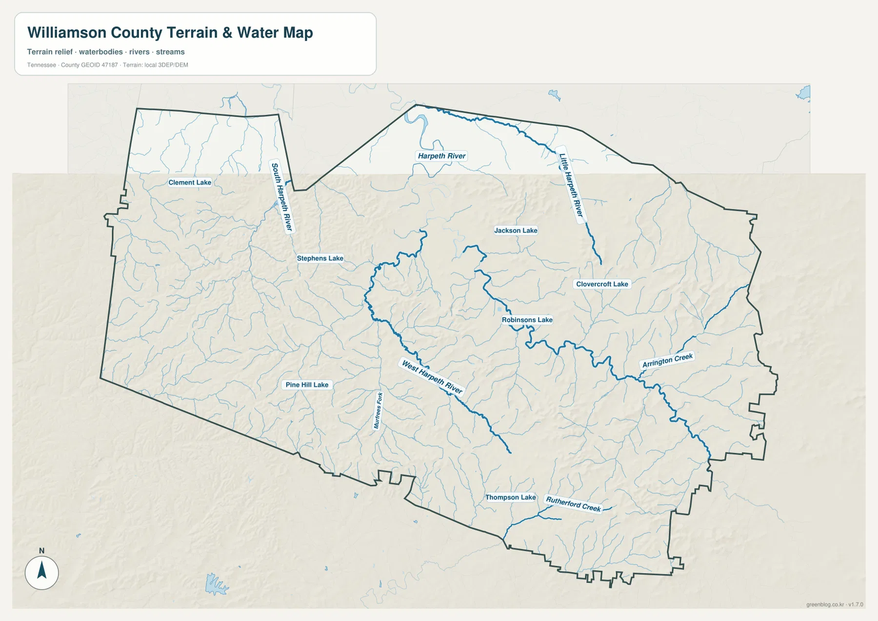
This is a static geographic reference rather than a live flood or boating map. It does not show current river stage, flood boundaries, water depth, safe navigation, or legal parcel lines. Current flood risk or water access along Harpeth River and its tributaries should be checked with current official hydrology and emergency information.
Low central valleys sit between higher eastern, southeastern, and western ridges
The elevation map gives Williamson County an actual range of about 106 to 381 meters and a mean near 239 meters. Broad green areas occupy much of the central Franklin corridor and several Harpeth River valleys. Higher tan and brown terrain appears in clusters rather than as one continuous mountain block, creating a rolling landscape of ridges and stream-cut lows.
The east and southeast contain some of the clearest high ridges, with additional rugged ground across the west and southwest. Brentwood is not flat, but it sits within a relatively accessible northern-central setting compared with the more deeply cut hills farther east. Fairview’s side of the county has a distinctly more broken relief pattern, while the Franklin–Thompson’s Station corridor includes broader lower passages.
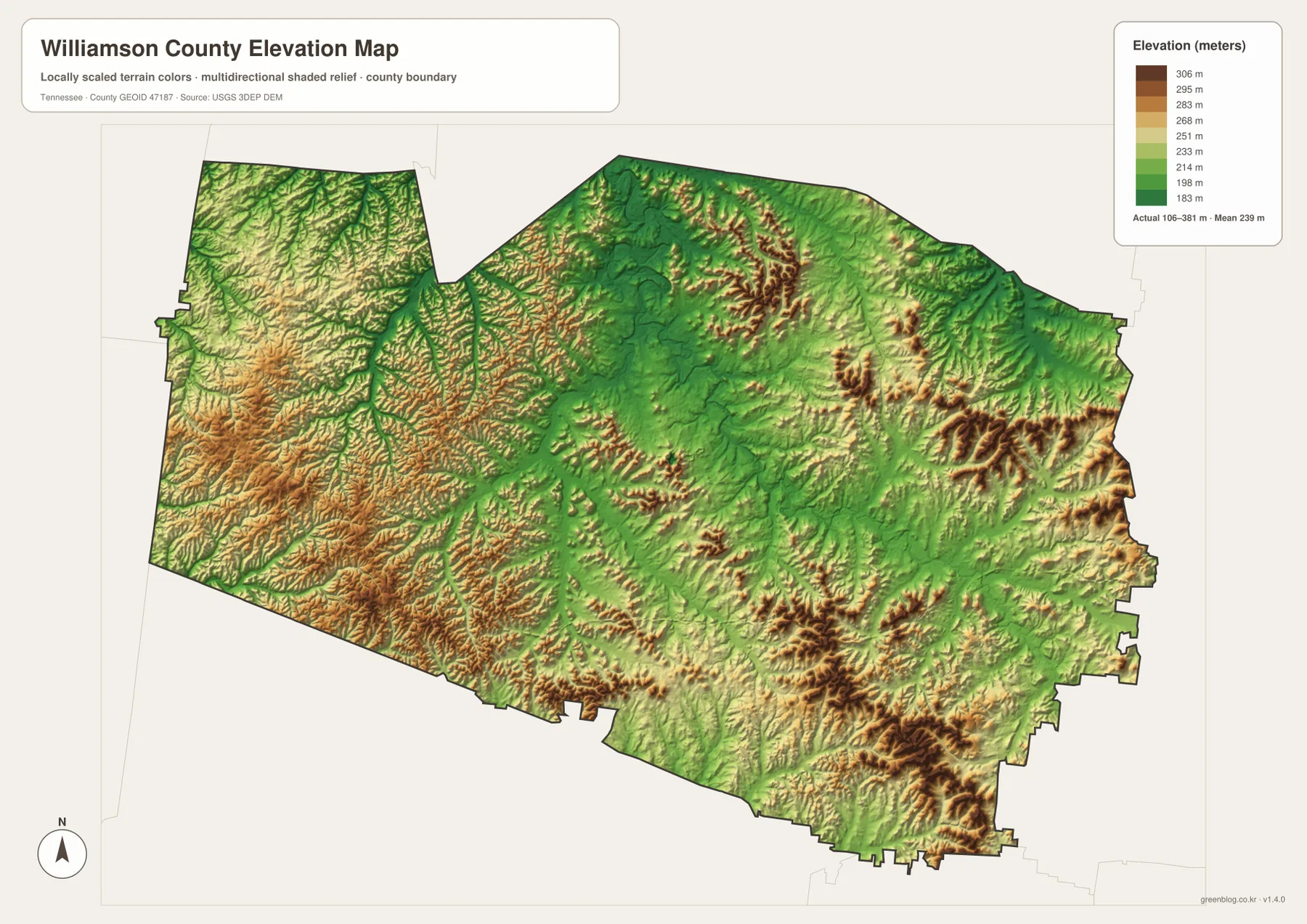
This relief helps explain why roads and development do not spread evenly in every direction. Valleys provide easier corridors, while ridges and streams can bend routes or separate nearby neighborhoods. The elevation layer is appropriate for county-scale comparison, not for determining an exact parcel elevation, construction grade, slope stability, or engineering design.
Development follows several corridors rather than one continuous suburban sheet
The general map shows large developed areas around Franklin and Brentwood, with another strong southward sequence through Thompson’s Station and Spring Hill. It can be tempting to treat that entire band as one continuous city, but municipal boundaries, creek valleys, and ridges still create meaningful breaks. The road and elevation maps reveal those divisions more clearly than a simple built-area color.
Nolensville forms a separate eastern center, and Fairview is even more detached on the western side. Their positions make Williamson County a multi-center county linked by transportation corridors rather than a single circular suburb around Franklin. This county-specific pattern is especially useful when comparing city growth, road access, and the Harpeth drainage system.
The July 2025 estimate of 272,061 is higher than the 2020 census count of 247,726, but those county totals do not reveal exactly where growth occurred. The city map should therefore be used to understand the locations of major centers, while detailed population change requires separate current census or local planning data.
Choosing the Williamson County map that matches the task
The general county map is the best first choice when you need Franklin, surrounding cities, major roads, and the county boundary together. Use the city map when the question is how Brentwood, Nolensville, Fairview, and Thompson’s Station relate to Franklin. The water map provides the clearest view of the Harpeth River branches and smaller lakes, while the elevation map explains the difference between the lower central corridors and surrounding hills.
For printed study or annotation, separate urban transportation from physical geography. One copy can emphasize Franklin and the surrounding city centers, while another can mark Harpeth River, West Harpeth River, Little Harpeth River, and the higher southeastern and western ridges. This keeps the page readable and makes the relationship between development and terrain easier to see.
Williamson County was established in 1799, and Franklin is the county seat in the supplied reference material. Franklin therefore combines an administrative role with a strong modern urban role, but the map also makes clear that Brentwood, Nolensville, Fairview, Thompson’s Station, and Spring Hill are essential to understanding the county as a whole.
Frequently Asked Questions
Which major center is closest to Franklin on the city map?
Thompson’s Station is shown about 6 miles from Franklin by direct distance, followed by Brentwood at about 8 miles. Nolensville is about 11 miles away and Fairview about 15 miles. These are straight-line comparisons rather than driving distances.
How does the Harpeth River system cross Williamson County?
The main Harpeth River follows the northern part of the county, while Little Harpeth River, West Harpeth River, and South Harpeth River occupy separate tributary valleys. Arrington Creek and Rutherford Creek add important eastern and southeastern drainage references. Current flood conditions require live official data.
Where is the highest terrain on the Williamson County elevation map?
Higher ridges are most noticeable in the east and southeast, with additional rugged terrain in parts of the west and southwest. The supplied elevation map ranges from about 106 to 381 meters, with a mean near 239 meters, while Franklin and several Harpeth valleys occupy lower ground.
Map File Information
The ZIP contains the high-resolution JPG originals for the Williamson County map, city map, water map, and elevation map shown on this page. The four A3-format images are better suited to printing, enlarged viewing, and annotation than the WebP previews in the article.
- Included Files: County map, city map, water map, and elevation map
- File Type: ZIP containing 4 JPG images
Related Maps
- Franklin County Tennessee map | Tims Ford and Sewanee Upland
- Alamo to Gadsden: A Crockett County Tennessee Map
- Altamont, Monteagle, and Plateau Valleys — Grundy County Tennessee Map
Sources and References
- Tennessee State Library and Archives Williamson County fact sheet
- Tennessee Department of Transportation Williamson County map
- U.S. Census Bureau Williamson County QuickFacts
- USGS National Hydrography
- USGS 3D Elevation Program
Green Map creates custom-edited map images using open geographic data sources such as geoBoundaries, Natural Earth, OpenStreetMap, and government open data. These maps are edited visual materials, not raw data files, and are provided for education, documents, presentations, and graphic reference.