Blairsville is the easiest place to orient yourself on a map of Union County, but the county is defined just as strongly by the mountains and water around it. Roads converge near the county seat, Lake Nottely spreads through branching valleys to the northwest, and a dense network of streams occupies the lower ground between ridges. The elevation map shows an especially large contrast for a Georgia county, with mapped terrain ranging from roughly 468 to 1,449 meters. The four map files on this page can also be downloaded together as high-resolution A3 JPGs.
The maps are meant to work as a set rather than as four copies of the same information. The county map is best for roads, the outline, and general place context. The city version strips the view down to Blairsville as the ranked major city. The water map makes Lake Nottely, the Nottely River, and smaller mountain streams much easier to follow, while the elevation surface explains why those streams and roads bend through narrow corridors. These are general reference maps, not parcel, flood-risk, navigation, or survey products.
Union County was established in 1832, and Blairsville is the county seat. The existing county background also identifies Lake Nottely and Brasstown Bald as important parts of the local mountain setting. Instead of treating those names as a checklist, the sections below use the supplied maps to show how the county’s settlement pattern, roads, water, and relief fit together.
Table of Contents
Blairsville sits where the county’s main road corridors come together
On the county reference map, Blairsville appears near the north-central part of the county and acts as the clearest road junction. Route 76 runs east-west through town, while the 19 and 129 corridor heads south from Blairsville with Route 11 also marked along that general path. Route 515 approaches from the east. Smaller numbered routes fan into the more irregular mountain portions of the county: 325 is visible toward the Lake Nottely side, 348 serves the southeast, and 180 and 60 appear in the southwest.
That pattern matters because Union County is not laid out like a flat county with a simple grid. The county boundary has several bends, narrow extensions, and angled segments that follow a mountainous region. Fannin, Lumpkin, and Dawson counties provide useful context on the west and southwest side of the map, while Towns and White counties appear to the east and southeast. Nearby labels outside the boundary, including Young Harris, help place Union County within the wider North Georgia mountain area without implying that those places are inside the county.
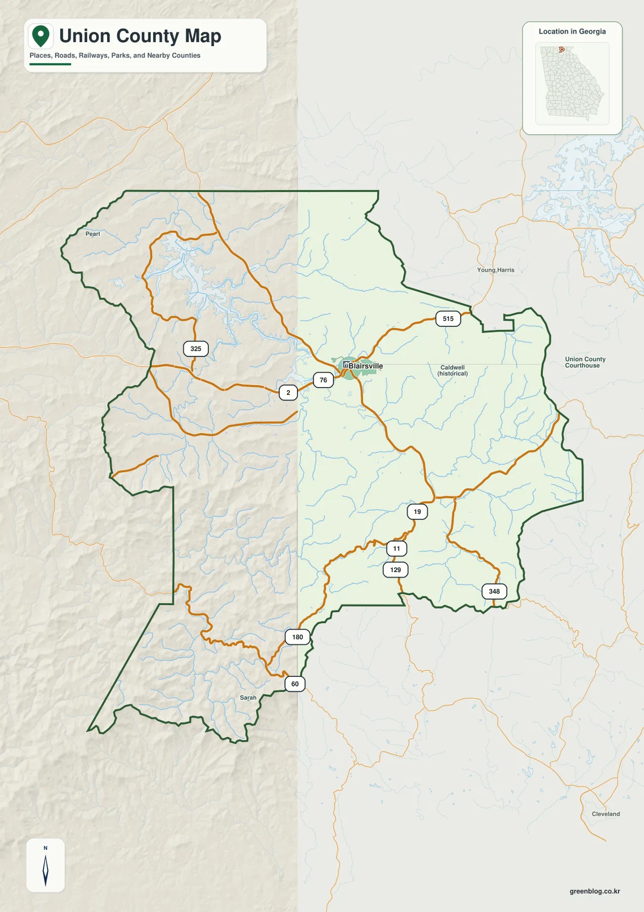
A practical way to read this version is to start with Blairsville and then move outward along the road that matches the direction you need. Lake Nottely lies northwest of the county seat, so the western road network is the relevant part of the map for lake-side orientation. Travel toward Towns County is east of Blairsville, while the 19/129 corridor provides a strong southbound reference. This approach makes the irregular county outline much easier to understand than trying to memorize the boundary first.
Why the city map highlights only Blairsville
The city-distribution map contains one ranked major city: Blairsville. Because there is only one ranked city in this layer, there are no connector lines or intercity distances to compare. That absence is useful information. It shows that this particular map is not trying to represent every unincorporated community, crossroads, or neighborhood. Its purpose is to make the county seat stand out clearly against the full county shape and surrounding counties.
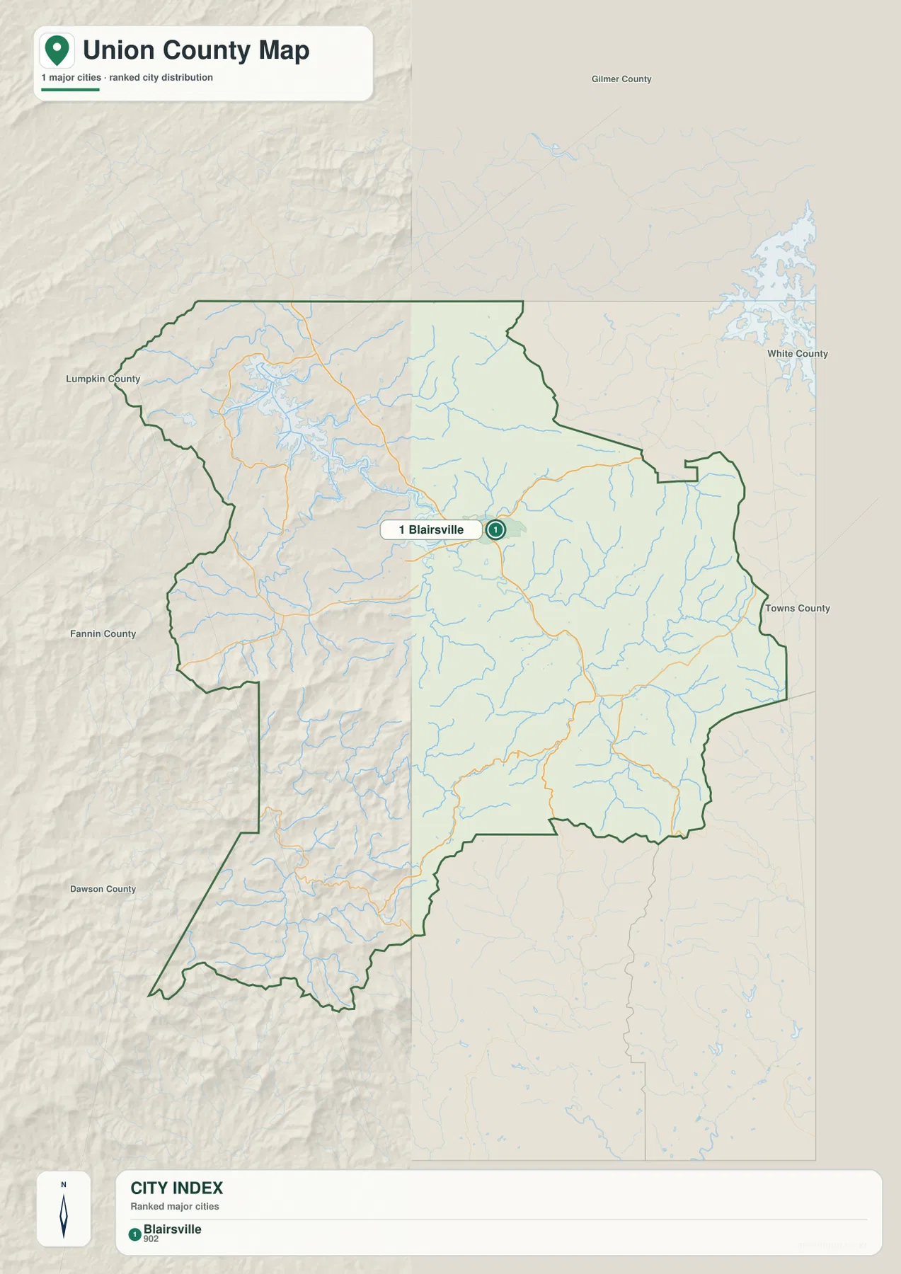
Blairsville is slightly north of the visual center of the county, with roads extending west toward the Lake Nottely area, east toward the Towns County side, and south through the mountain valleys. The surrounding labels for Fannin, Lumpkin, Dawson, Towns, and White counties provide directional context. If a city map contains multiple ranked places, connector distances would be straight-line distances rather than driving mileage; in this case, no such connectors are drawn because only Blairsville is selected.
This simplified view is useful when a presentation or classroom activity needs one clean reference point. It can also help a reader who first encounters the much busier county map. Find Blairsville here, remember its position, and then return to the road or water version. The added information becomes easier to organize once the county seat is fixed in mind.
Lake Nottely anchors a dense network of mountain water
The water map changes the visual emphasis of Union County immediately. Lake Nottely is the dominant open-water feature in the northwest, with a branching shoreline that reaches into several valleys instead of forming a compact oval. Dooley Creek and Conley Creek are labeled near the lake, and Dean Pond appears just to its south. Numerous smaller tributaries fill the slopes around those named waters, so the northwest corner looks more like a connected drainage network than a single isolated reservoir.
Farther east, Arkaqua Creek and Town Creek are among the named streams visible on the map. The Nottely River becomes a major labeled channel in the southeast and south-central part of the county. Lake Trahlyta and Lake Winfield Scott appear in the southern mountain area, while the southwest extension includes the Toccoa River and Woody Lake. These labels provide useful local anchors without requiring the reader to identify every small blue tributary on the map.
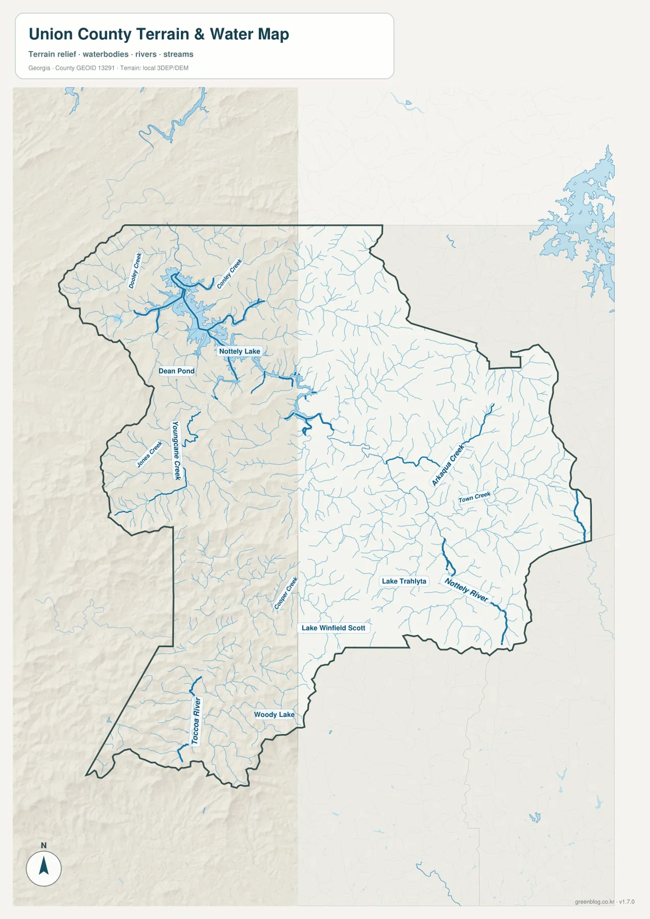
The sheer number of small stream lines is important when compared with the terrain. They repeatedly occupy the lower spaces between ridges, and their direction helps explain why roads curve rather than forming a regular grid. Around Lake Nottely, the shoreline follows multiple narrow valleys. In the south and east, tributaries converge toward larger channels such as the Nottely River. The map is therefore useful for geographic orientation, but it should not be treated as a flood map, a property-boundary map, a real-time water-level source, or a navigation chart.
Elevation reveals ridges that roads and streams have to work around
The elevation map gives Union County a very different appearance from the road map. Its legend reports an actual mapped range of about 468 to 1,449 meters and a mean elevation of about 719 meters. Greens mark lower terrain, while yellow, tan, and brown tones climb toward the higher ridges. Rather than one broad high plateau, the county contains repeated ridges separated by lower valleys, producing a textured surface across nearly the entire boundary.
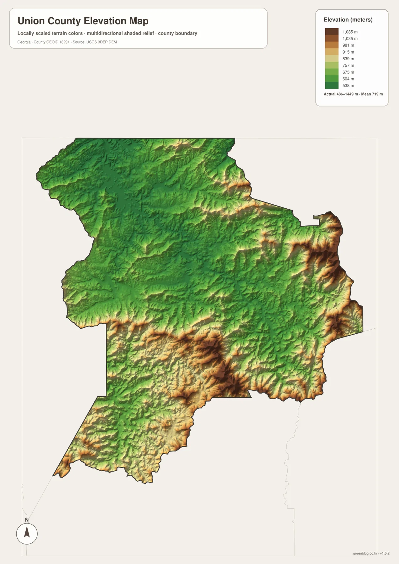
Some of the strongest high-elevation colors appear along the eastern side and across parts of the south and southwest, with additional high ridges in the northern mountains. Lower green corridors thread between them. The result helps explain the basic shape of both the road and water networks: streams use the low ground, and roads often follow the same broader valleys or cross the ridges at limited points. The mountain setting associated with places such as Brasstown Bald is therefore not just background description; it is visible in the county-wide relief.
This surface should be used for comparison, not precision engineering. A color band can show that one part of the county is generally higher than another, but it does not replace a survey, a site-specific contour map, or field measurements. For a reader who wants to understand why a short straight-line separation may involve a much longer drive through the mountains, however, the elevation map is often the most revealing of the four versions.
Reading the same places across all four maps
Lake Nottely is a good example of why the set works better than a single map. The county version shows the lake in relation to Blairsville, the county boundary, and numbered roads. The water map then exposes the lake’s branching shoreline and the tributaries feeding it. On the elevation surface, the surrounding ridges and lower valley arms become visible. What initially looks like a complicated reservoir outline makes much more sense once the mountain relief is added.
Blairsville can be read the same way. The city map isolates it as the primary ranked settlement. The county map shows Route 76 and the north-south 19/129 corridor around it. The water map adds a web of small streams, while the elevation map places the town in lower terrain between higher ridges. Each version answers a different practical question without requiring the page to overload one image with every possible label.
The southern part of the county also changes depending on the layer. The water map identifies Lake Trahlyta, Lake Winfield Scott, the Toccoa River, and other channels, while the elevation version emphasizes the steep ridge-and-valley setting around them. The road map shows how numbered routes pass through those areas. For a local-history explanation, travel overview, or geography lesson, moving between these layers gives a much clearer picture of Union County than a generic boundary outline alone.
Choose the map that matches the question
Use the county map when you need the boundary, Blairsville, major numbered roads, and broad surrounding context in one image. Choose the city map when Blairsville itself is the focus and extra detail would distract from the location. The water map is the clearest option for Lake Nottely, the Nottely River, named creeks, and the smaller tributary network. The elevation map is best when the subject is mountain relief, the contrast between ridges and valleys, or the physical setting behind winding roads and streams.
The web page uses lighter WebP previews, while the downloadable archive contains four separate high-resolution A3 JPG files. This makes it possible to print one map, place a different one in a report, or compare several versions side by side without relying on screenshots. The files are geographic references; official decisions involving property lines, flood risk, engineering elevations, road closures, or legal jurisdiction should be checked against the current records of the responsible agency.
Frequently Asked Questions
Where is Lake Nottely in relation to Blairsville?
Lake Nottely is northwest of Blairsville on the supplied maps. Its long, branching shoreline is easiest to see on the water version, where several tributaries and nearby named waters are also shown.
Why does the city map show only one ranked city?
The city layer uses a ranked-major-city selection rather than displaying every community in the county. Blairsville is the only ranked city shown in this version, so there are no intercity connector lines. Other communities are not being declared absent; they are simply outside the selection used for this map.
What does the 468–1,449 meter elevation range mean?
It is the approximate actual range reported by the supplied county elevation surface. It is useful for comparing high ridges with lower valleys across Union County, but it is not a substitute for a site survey or engineering-grade elevation measurement.
Sources and reference data
The article uses the supplied four-map package as its main geographic reference. The following public sources provide additional county background, hydrography, elevation, and demographic context.
- U.S. Census Bureau QuickFacts for Union County
- Official Union County history page
- New Georgia Encyclopedia: Union County
- USGS National Hydrography
- USGS 3D Elevation Program
Map File Information
The ZIP contains four high-resolution A3 JPG maps of Union County: county, city, water, and elevation versions.
- Included Files: County map, city map, water map, elevation map
- File Type: Four high-resolution A3 JPG files
Related Maps
Green Map creates custom-edited map images using open geographic data sources such as geoBoundaries, Natural Earth, OpenStreetMap, and government open data. These maps are edited visual materials, not raw data files, and are provided for education, documents, presentations, and graphic reference.