Haywood County is one of those mountain counties where a single town does not explain the whole map. Waynesville sits in the south-central valley, Lake Junaluska is just to its north, Canton and Clyde are farther east, and Maggie Valley is set apart to the west. Between those communities, the Pigeon River and a dense network of mountain streams follow narrow valleys framed by high ridges. This page uses the actual county, city, and water-and-terrain maps to explain those relationships, and after viewing the previews you can download the three A3 high-resolution JPG map files in one ZIP.
Haywood County government describes the county as a high-elevation part of western North Carolina with numerous peaks above 6,000 feet. That fact matters when reading even a simple road map. Settlement is concentrated in the more accessible valleys, while much of the county boundary runs through steep mountain terrain. Roads that look close together may be separated by ridges, and straight-line distances between towns can be much shorter than the route a vehicle must actually take. The most useful way to read Haywood is therefore to combine town locations, road corridors, waterways, and terrain instead of treating them as separate pieces of information.
Table of Contents
Waynesville and Canton reveal the county’s main valley corridor
Start with Waynesville on the general county map. The county seat is shown near the south-central part of Haywood, with Lake Junaluska immediately to the north. Maggie Valley lies to the west, while Clyde and Canton extend the settlement pattern eastward. Those places do not form one continuous city, but they occupy the broadest and most connected valley zone on the map. Once that band is located, the large mountain areas around it become easier to understand because the contrast between settled valleys and steep outer terrain is obvious.
The road pattern reinforces the same geography. The map shows U.S. 19, U.S. 23, U.S. 74, Interstate 40, North Carolina 209, U.S. 276, North Carolina 110, and North Carolina 215. Several routes come together around the Waynesville area, while the eastern corridor becomes more prominent toward Canton and I-40. Other routes head north or south through narrower mountain valleys. North Carolina 209, U.S. 276, and North Carolina 215 are especially useful reminders that travel away from the central valley depends on a limited number of mountain passages rather than a dense grid of roads.
The county boundary adds another layer of orientation. Within North Carolina, Haywood borders Madison, Buncombe, Transylvania, Jackson, and Swain counties, and its northern edge reaches Tennessee. That makes the eastern side of the map the Asheville/Buncombe direction, while the western and southwestern sides lead toward the Smokies, Jackson County, and Swain County. This broad relationship is more useful than trying to memorize every small road. If your purpose is simply to understand where a community sits within the county, locate Waynesville first, then use the major highways and county boundary to decide which direction to move.
Maggie Valley, Waynesville, Clyde, and Canton occupy different mountain passages
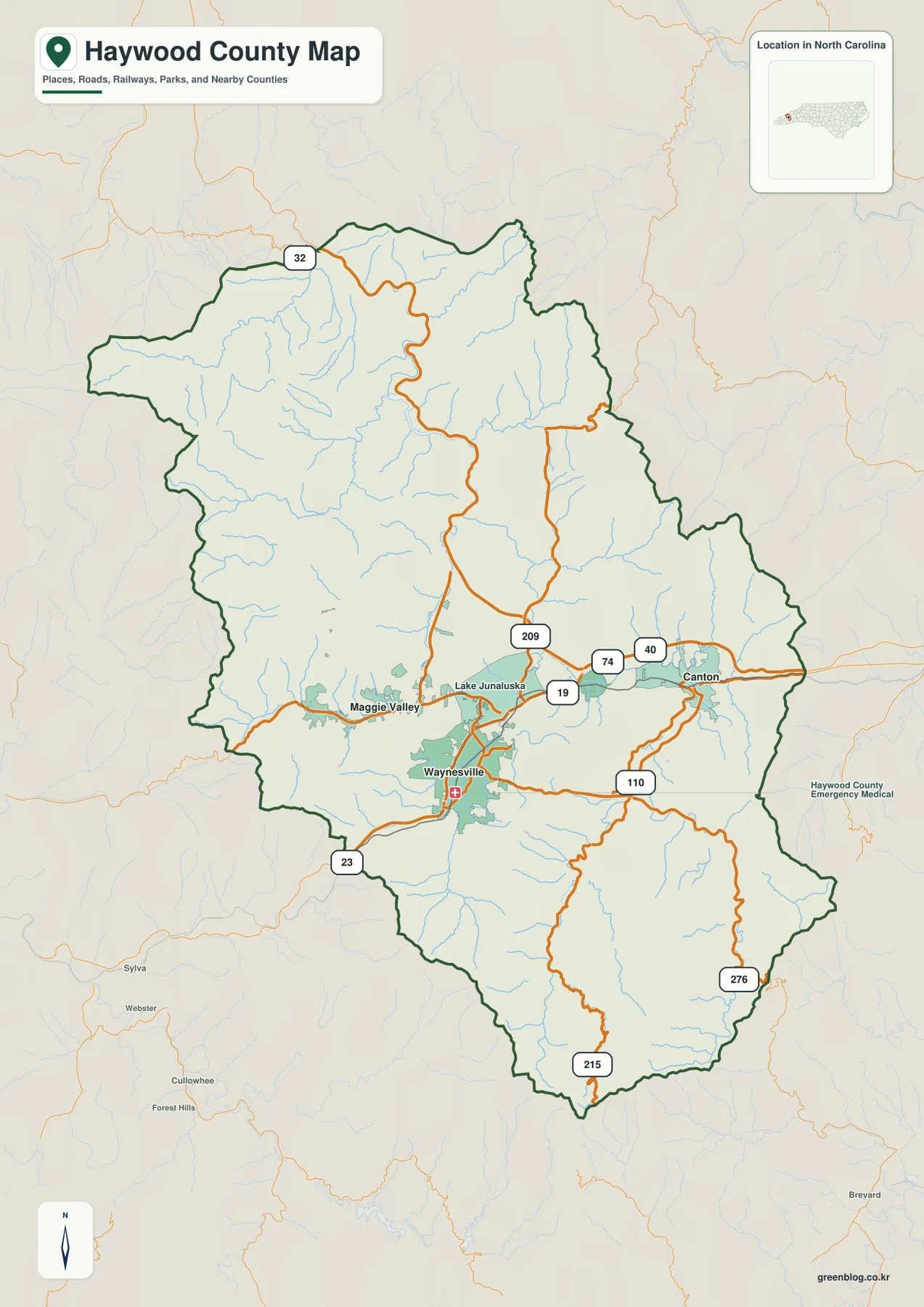
The city-connections map simplifies Haywood County by highlighting its four incorporated towns: Waynesville, Maggie Valley, Clyde, and Canton. The map uses Waynesville as the hub, which is helpful for comparison but should not be mistaken for a statement that every community belongs to one compact urban area. Maggie Valley is west of Waynesville, Clyde is to the northeast, and Canton is farther east. Their spacing shows how settlement follows several connected but distinct valleys rather than spreading evenly across the mountain landscape.
The distance labels on this map are straight-line distances from Waynesville, not driving distances. That distinction is important in Haywood County because mountain ridges force roads to bend, climb, and follow stream valleys. Maggie Valley may appear quite close to Waynesville on the map, yet the actual road corridor matters more than the direct line. Canton also looks relatively near, but it belongs to the eastern valley and I-40 side of the county. Anyone planning a trip should use the city map for orientation and a current road or navigation service for actual mileage and travel time.
Clyde is especially useful as a middle reference. It sits between the Waynesville/Lake Junaluska area and Canton, making it easier to see the transition from the county seat area to eastern Haywood. Maggie Valley does the opposite: it pulls the reader westward toward a narrower mountain corridor associated with the Great Smoky Mountains side of the county. Looking at these towns as directional anchors makes the map more practical for visitors, local reference sheets, and anyone comparing Haywood with neighboring mountain counties.
The Pigeon River collects streams that begin high inside the county
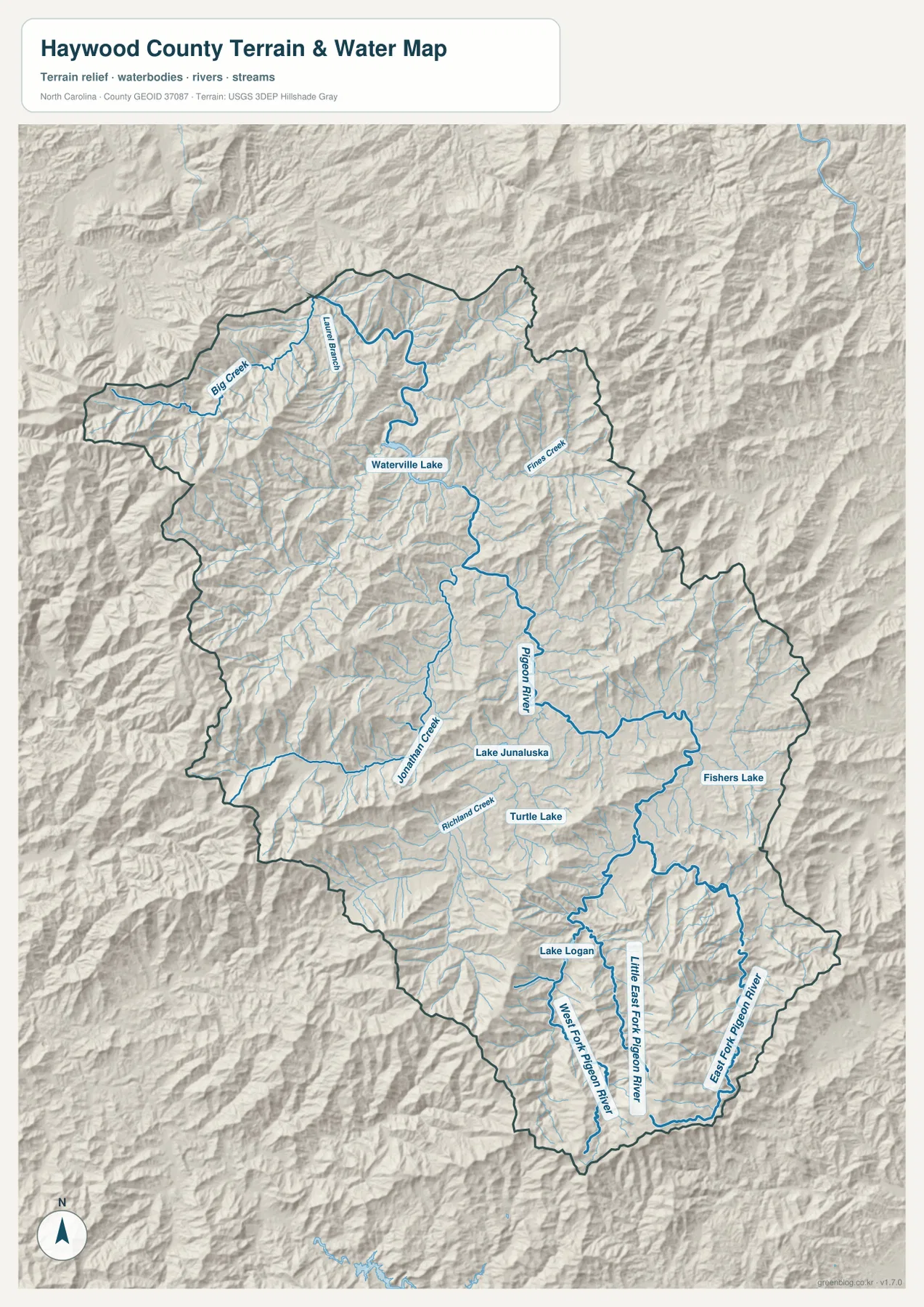
The water-and-terrain map shows why Haywood County cannot be read as a flat road network. Numerous streams begin in the mountains and descend into larger valleys, with much of the drainage eventually joining the Pigeon River system. Haywood County’s own Fast Facts page notes that the county’s rivers and springs originate within the county. On the map, that statement becomes visual: the outer ridges contain many short headwater streams, while the larger named channels become more continuous as they move through the interior.
In southern Haywood, the West Fork Pigeon River, Little East Fork Pigeon River, and East Fork Pigeon River occupy separate mountain valleys. Farther north, the main Pigeon River continues through the county, while Richland Creek and Jonathan Creek help define the Waynesville and Lake Junaluska area. Northern labels such as Fines Creek, Big Creek, and Laurel Branch show another set of narrow watersheds, and Waterville Lake appears toward the upper part of the county. Together, these features explain why the terrain is divided into so many distinct local corridors.
The map also marks Lake Junaluska, Lake Logan, Turtle Lake, and Fishers Lake. These smaller water bodies are useful local reference points because they break up a map that might otherwise seem dominated by one river name. Lake Junaluska is closely tied to the central settlement area, while Lake Logan sits farther south among mountainous tributaries. The shaded relief in the background helps connect every river and lake to the surrounding slopes. This is a reference map for waterways and terrain, not a flood-hazard, parcel, legal-boundary, or navigation map, so those specialized questions require the appropriate official source.
High ridges make nearby places behave like separate travel corridors
Haywood’s mountain relief is not decorative background. The county government’s Fast Facts list includes thirteen peaks above 6,000 feet, among them Richland Balsam, Waterrock Knob, Cold Mountain, and Mount Guyot. That level of relief explains why towns can be close in a straight line yet function as separate travel corridors. A ridge between two points can matter more than the number of miles shown on a simple city diagram.
The general county map makes this especially clear when the central valley is compared with roads leading toward the outer boundary. Around Waynesville and Canton, several major routes are visible at once. In the northern and southern mountains, fewer through routes are available, and those roads tend to follow valleys or cross specific gaps. North Carolina 209 heads toward the northern mountains, U.S. 276 crosses the southern part of the county, and North Carolina 215 follows another mountain corridor. Reading those lines together with the shaded terrain prevents the common mistake of assuming that the shortest-looking line is also the easiest route.
Great Smoky Mountains National Park and the Blue Ridge Parkway add another reason to pay attention to terrain. Haywood County government notes that the county includes part of the national park and several access points to the parkway. The maps on this page are not trail or park-service maps, but they are useful for establishing the county-scale relationship between the settled valleys and the higher protected landscape. For a hike, park visit, or mountain drive, use this county map to establish direction first and then switch to current National Park Service or road information for the detailed route.
Choose the map according to the question you are trying to answer
The general county map is the best first choice when you need roads, town locations, and the boundary on one page. It is well suited to questions such as where Maggie Valley sits relative to Waynesville, which direction Canton lies, or which main route leaves the central valley toward the north or south. It does not replace a street-level navigation map, but it gives enough regional context to decide where to zoom next.
The city-connections map is more useful when the four municipalities are the main subject. Because it removes many smaller labels, the separation among Waynesville, Maggie Valley, Clyde, and Canton becomes easier to see. Remember that the connector distances are straight-line measurements. In a flatter county that limitation might be minor, but in Haywood it is a major reason not to use the diagram as a driving-distance chart.
The terrain-and-water map is the strongest choice for understanding the physical landscape. It makes the Pigeon River, East Fork and West Fork systems, Richland Creek, Jonathan Creek, Fines Creek, lakes, and shaded mountain relief visible together. That combination is especially helpful when comparing settlement with valleys or explaining why the county’s roads follow certain corridors. The three maps therefore answer different questions: one emphasizes roads and boundaries, one emphasizes town relationships, and one emphasizes the mountains and water that shape both.
Use the high-resolution JPG files when the web preview is too small
The WebP images in the article are optimized for quick viewing. If you need a larger copy for printing, classroom material, a local reference sheet, a presentation, or your own project, the ZIP below contains the same three maps as A3 high-resolution JPG files. Keeping them in one archive makes it easy to switch between the general, city-connections, and terrain-and-water versions without downloading separate files. For detailed labels and small streams, opening the original JPG is much more useful than enlarging the browser preview.
Frequently Asked Questions
Where should I look first to find Waynesville on the Haywood County map?
Look in the south-central valley where several major road corridors meet. Lake Junaluska is immediately north of Waynesville, Maggie Valley is west, and Clyde and Canton are to the east. Using those surrounding places together with U.S. 19, U.S. 23, U.S. 74, and U.S. 276 makes the county seat easy to identify.
Why should the city-map distances not be treated as driving mileage?
The city-connections map uses straight-line distance from Waynesville. Haywood County has steep ridges and narrow valleys, so roads often bend around mountains or use a limited number of passes. The diagram is excellent for comparing direction and relative spacing, but actual driving distance and time should be checked with a current road or navigation source.
What waterways can I identify besides the main Pigeon River?
The terrain-and-water map labels the West Fork Pigeon River, Little East Fork Pigeon River, East Fork Pigeon River, Richland Creek, Jonathan Creek, Fines Creek, Big Creek, and Laurel Branch. It also marks Lake Junaluska, Lake Logan, Waterville Lake, Turtle Lake, and Fishers Lake, giving you both large and small water references across the county.
Sources and Reference Data
- Haywood County Government – About Haywood County
- Haywood County Government – Fast Facts
- NCpedia – Haywood County
- U.S. Census Bureau – TIGER/Line Shapefiles
- USGS – National Hydrography
- USGS – 3D Elevation Program
Map File Information
The ZIP contains three A3 high-resolution JPG files for Haywood County.
- Included Files: Use only the versions confirmed in the article and supplied images
- File Type: Use the confirmed download contents
- Intended Use: Printing, education, presentations, and map-based projects
Related Maps
Green Map creates custom-edited map images using open geographic data sources such as geoBoundaries, Natural Earth, OpenStreetMap, and government open data.
These maps are edited visual materials, not raw data files, and are provided for education, documents, presentations, and graphic reference.