Hernando County changes character quickly from the Gulf side to the inland river country, which is why a single label such as “Brooksville area” does not describe the whole county very well. The map set on this page lets you place Brooksville, Spring Hill, Weeki Wachee, Hernando Beach, Ridge Manor, the major road corridors, and the main mapped waterways in one county-scale view. High-resolution A3 JPG versions are available as a ZIP in the map file box below.
The western side is shaped by coastal water, marshy inlets, and the Weeki Wachee system. Move inland and the map becomes more suburban around Spring Hill before tightening around Brooksville, where several major roads meet. Farther east, Ridge Manor, U.S. 301, I-75, and the Withlacoochee-side waterways create a different pattern again. Looking at those zones separately makes the county much easier to understand than treating every labeled place as part of one continuous urban strip.
This page supplies a county reference map, a simplified city-index map, and a terrain-and-water map. They are not interchangeable. The first is best for place names and road relationships, the second isolates the ranked city shown by the map, and the third brings rivers, creeks, coastal water, ponds, and broad terrain relief forward. The article follows that same practical sequence rather than repeating a generic description for each image.
Table of Contents
A county that stretches from Gulf communities to an eastern road-and-river corridor
The county reference map gives the clearest overall orientation. Hernando’s west edge is irregular where the land meets Gulf water, while the county extends eastward in a long shape toward Ridge Manor. The neighboring-county labels on the companion city map place Citrus County to the north, Sumter County to the east, and Pasco County to the south. That frame matters because several roads continue directly into those surrounding counties and can make the local map look more connected than the county boundary actually is.
U.S. 19 is the main north-south reference on the western side, passing the Weeki Wachee and Spring Hill area. SR 50 provides the strongest east-west line, running from the U.S. 19 side through Brooksville and then toward Ridge Manor and I-75. Around Brooksville, U.S. 41 and U.S. 98 are also prominent. On the eastern side, U.S. 301 and I-75 become more important, while the route marked 589 forms another north-south corridor east of much of Spring Hill.
Place labels show why the road network should be read with the communities instead of by number alone. Brooksville appears north and east of the county’s middle, with North Brooksville and South Brooksville nearby. Spring Hill occupies a much broader area to the southwest, close to High Point, Brookridge, and Timber Pines. Hernando Beach, Weeki Wachee Gardens, and North Weeki Wachee sit on the western side but do not share one identical access pattern. Ridge Manor, Hill ’n Dale, and Spring Lake belong to the eastern half of the map and connect to a different set of roads.
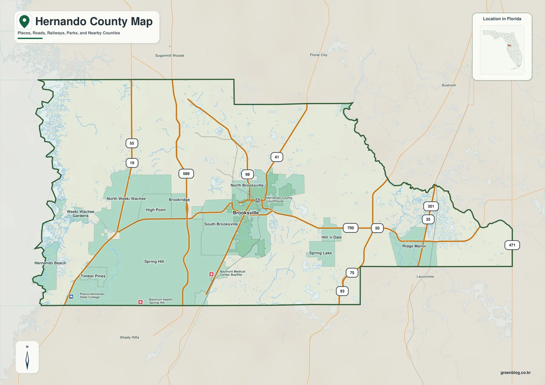
The shape of the county is especially useful when planning a cross-county trip. A destination that looks only a short distance east or west on the page may require a route built around one of a few major corridors rather than a straight local road. The coastal side has many water features and irregular edges, while the eastern side narrows toward the SR 50, U.S. 301, and I-75 area. For county-scale orientation, that difference is more useful than trying to memorize every minor street.
Brooksville is the city index, not the whole population story
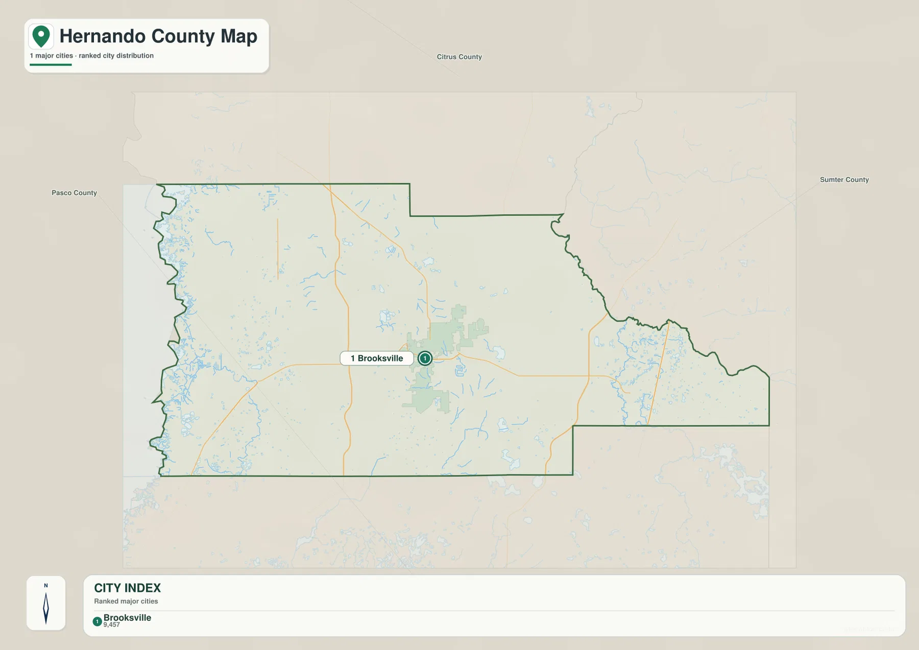
The city map is intentionally sparse. It ranks only Brooksville as a major city within the map’s city index and marks it with a single numbered symbol. The printed index shows 9,457 beneath Brooksville’s name. Because the preview does not identify the reference year for that number, it should be treated as the map’s displayed index value rather than quoted here as a current population estimate.
That single city marker does not mean Spring Hill or the western communities are insignificant. The supplied article materials describe Spring Hill as a large unincorporated census-designated place, and the county reference map shows a much broader Spring Hill footprint than the compact Brooksville area. Brooksville’s importance comes from its incorporated and county-seat role, while Spring Hill represents a different kind of settlement pattern. The city map is therefore useful for administrative orientation, not for ranking every populated community by size.
Weeki Wachee adds another reason to separate place names from municipal status. The existing article materials state that the former municipality was abolished in 2020, while the name remains in use for the spring, state park, river, and surrounding community. A reader can therefore see Weeki Wachee on a county map without assuming it functions as an incorporated city today.
The companion map also helps with regional direction. Citrus County is shown north of Hernando, Sumter County to the east, and Pasco County to the south. There are no intercity connector lines in this version, so it should not be used to infer city-to-city mileage or driving time. Its value is the opposite: it strips the county down to one ranked city and the surrounding county frame, making Brooksville’s position easy to spot.
Gulf-side springs and eastern Withlacoochee waters create two different water settings
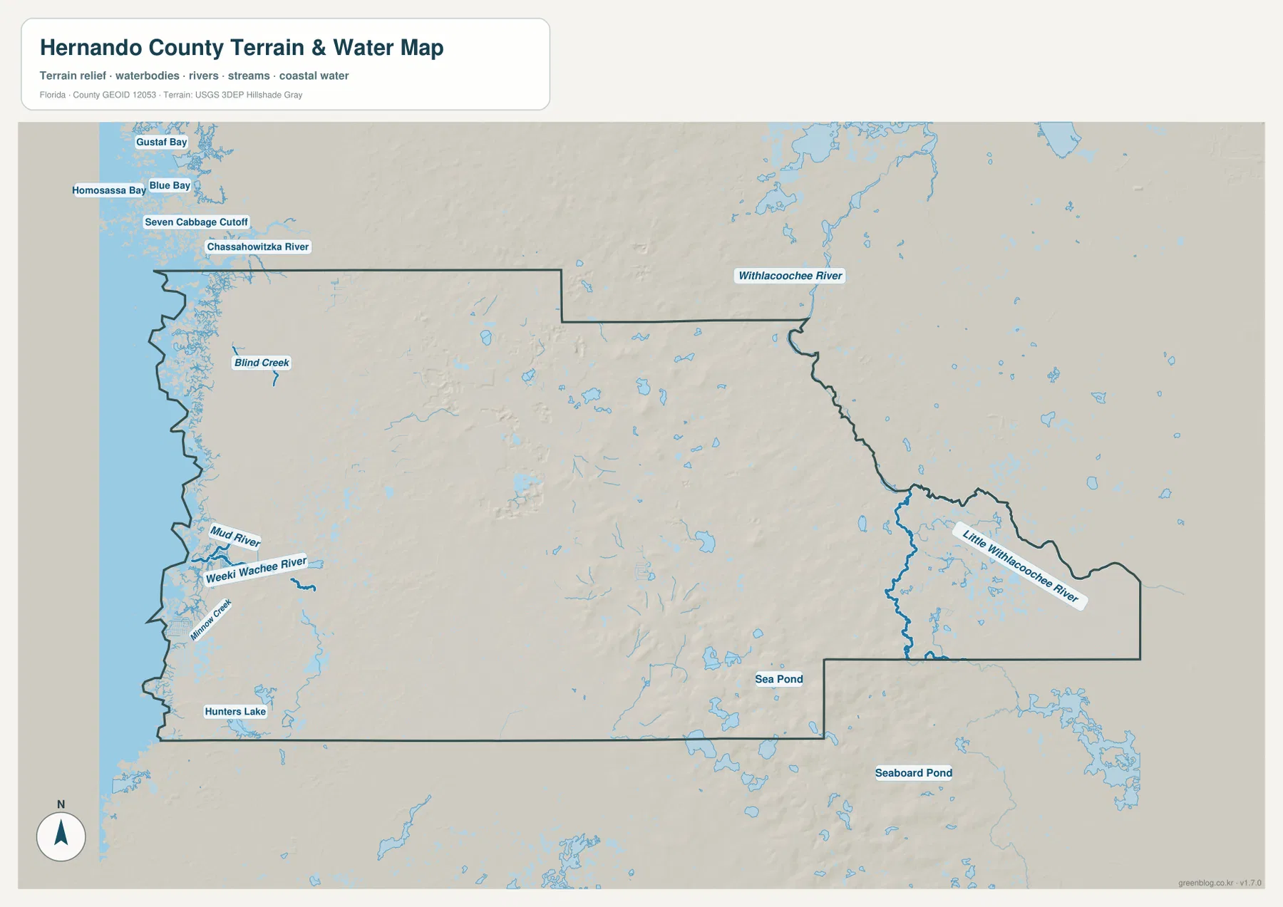
The terrain-and-water map changes the emphasis completely. On the western side, the Gulf edge and its connected waterways dominate the page. Blind Creek, Mud River, Weeki Wachee River, and Minnow Creek are labeled near the coast, while Hunters Lake appears farther south. That concentration of blue features explains why a simple road map does not fully describe the western edge of Hernando County.
Weeki Wachee River is the clearest named river on the western side of the county. The retained article materials connect it with Weeki Wachee Springs and official protection information. On this map, its practical value is location: you can see how the river runs toward the Gulf and how it sits relative to the county’s western communities. The image is not a navigation chart, however, and it does not show boating depth, legal access, flood-insurance zones, or parcel restrictions.
The eastern side tells a different story. Little Withlacoochee River bends through the far eastern part of the county map, and Withlacoochee River is labeled along the broader northeastern side. Sea Pond and Seaboard Pond also appear in the southeastern area. Those features are separated from the Gulf-side river network by a broad inland middle, so it is more accurate to think of Hernando as having a western spring-and-coast setting and an eastern river-country setting rather than one single water corridor.
Terrain shading adds general relief but should stay in that general role. Brooksville and the inland center look more rolling than the low, water-cut western edge, yet the map does not provide survey elevations or engineering contours. It can help a reader understand why the county’s physical appearance changes from coast to interior, but it cannot decide whether a property is in a flood zone, whether a road will be passable after heavy rain, or what elevation is required for construction.
Road numbers become clearer when matched to the places they actually serve
A useful way to read the transportation pattern is to divide the county into four practical zones. For Weeki Wachee and the western commercial corridor, begin with U.S. 19. For Spring Hill, think of the broad area between U.S. 19 and the route marked 589. For Brooksville, focus on the cluster of U.S. 41, U.S. 98, and SR 50. For Ridge Manor and the far east, SR 50, U.S. 301, and I-75 become the stronger references. This approach turns a crowded set of route shields into a simple geographic framework.
The Gulf side deserves special caution because straight-line closeness does not guarantee a direct road. Hernando Beach, Weeki Wachee Gardens, and other western labels sit near a coast broken by water, marsh, and tidal channels. A county map can show which side of U.S. 19 a destination lies on, but a current navigation service is still needed for the final approach, closures, bridge conditions, or launch access.
The same distinction applies in the east. Brooksville and Ridge Manor are both inland, but they are not the same road environment. SR 50 is the main link between them, and the U.S. 301/I-75 area changes the regional travel options near Ridge Manor. When the water map is viewed alongside the road map, the curving eastern boundary and the Little Withlacoochee system also make more sense. Roads, county shape, and waterways are part of one geography even though each file emphasizes a different layer.
Which map file should you use first?
Use the county reference map when your first question is “Where is this place relative to the rest of Hernando County?” It is the best choice for comparing Brooksville, Spring Hill, Weeki Wachee, Hernando Beach, Ridge Manor, and the major numbered highways. It also works well as a printable overview because the boundary, place names, and transportation network appear together.
Use the city-index map when you specifically want the ranked city shown by this map set. In this case that is Brooksville alone, so the map is deliberately much simpler. It should not replace the county map for understanding Spring Hill or other unincorporated communities. Use the terrain-and-water map when rivers, coastal water, ponds, and broad relief matter more than municipal labels. Weeki Wachee River, Mud River, Little Withlacoochee River, and the Gulf edge stand out much more clearly there.
For teaching, printing, or local orientation, the three files work best as a sequence. Start with the county reference map to establish position, use the city map to explain Brooksville’s distinct role, and then switch to the water map to show why the western and eastern ends of the county feel so different. The downloadable JPG files preserve more detail than the web previews and are sized for larger viewing or print use.
The downloadable archive contains the three high-resolution A3 JPG files that correspond to the county reference, city, and terrain-and-water maps in the article. The file name is hernando_county_florida_3_map_jpg.zip. These larger JPGs are useful for printing, classroom material, presentations, and local orientation, but current road restrictions, parcel boundaries, flood determinations, and navigation rules should be checked with the responsible agencies.
Frequently Asked Questions
Why does the city map show Brooksville but not the much larger Spring Hill area?
The supplied city map is a ranked city index rather than a population map of every community. Brooksville is the incorporated city and county seat identified in the package, while Spring Hill is a large unincorporated census-designated place. Use the county reference map for Spring Hill’s footprint and the city map when you specifically want Brooksville’s city role.
Are Weeki Wachee River and Withlacoochee River on the same side of Hernando County?
No. Weeki Wachee River runs through the western spring-and-Gulf setting, while Withlacoochee River and Little Withlacoochee River are associated with the eastern and northeastern side. Looking at these as two separate water settings makes the county’s east-west geography easier to understand.
What is included in the downloadable ZIP?
The archive contains three high-resolution A3 JPG files matching the county reference map, the city map, and the terrain-and-water map shown on this page. They are the larger print-ready counterparts to the WebP previews used in the article.
Map File Information
Download the Hernando County reference map, city map, and terrain-and-water map together as high-resolution A3 JPG files in one ZIP archive.
- Included Files: 3 A3 JPG maps
Related Maps
- Arcadia Roads and Peace River | DeSoto County Florida Map
- Baker County Florida Map
- Blountstown, SR 20, and the Apalachicola River | Calhoun County Florida Map
Sources and official references
The article is based on the supplied maps and their retained reference material. For current road, county, park, water, parcel, or regulatory details, use the responsible agency’s latest information rather than treating this county-scale map as a live navigation or legal product.
- U.S. Census Bureau — Hernando County QuickFacts
- Florida DOT — county general highway maps
- Florida State Parks — Weeki Wachee Springs
- Florida DEP — Nature Coast Aquatic Preserve
- Hernando County — GeoHub
Green Map creates custom-edited map images using open geographic data sources such as geoBoundaries, Natural Earth, OpenStreetMap, and government open data. These maps are edited visual materials, not raw data files, and are provided for education, documents, presentations, and graphic reference.