Ada County in southwestern Idaho combines a dense northern urban area with a much larger southern landscape of creeks, open terrain, and lower-density settlement. Boise and Meridian form the clearest center of the county on the maps, while Eagle and Star sit farther northwest, Garden City follows the Boise River corridor, and Kuna stands south of the main urban cluster. To the east, the ground rises sharply toward the Lucky Peak area and the foothills; to the southwest, the Snake River bends along part of the county boundary. The maps on this page separate those features into boundary-and-road, city-distribution, water-and-terrain, and elevation views, and the original high-resolution JPG files are available together as a ZIP download.
The easiest way to orient yourself is to start with Boise City and Meridian, then work outward. Most of the named cities occupy the northern half of the county, where the road network is also most visible. Kuna marks a transition toward the long southern section, where city labels thin out and small streams become more noticeable. The eastern edge is different again: Lucky Peak and the dissected foothills create a much stronger relief pattern than the broad lower ground around Boise and Meridian. Looking at the four maps together makes these contrasts much easier to understand than trying to read every feature from a single crowded map.
Table of Contents
Boise, Meridian, and the road network inside the county boundary
The general county map shows the shape of Ada County along with its principal settlements and numbered highways. Boise City sits in the north-central to eastern part of the urban area, with Meridian directly west of it. Eagle is farther north, Star is near the western side, Garden City occupies a narrow area close to the Boise River, and Kuna is clearly separated to the south. Nampa appears outside the county on the western side, which gives useful regional context without confusing it with the places inside the county line.
The numbered routes make the urban pattern easier to follow. Route 16 runs through the Star and Eagle side of the county, while 55 continues north from Eagle. Route 21 heads east from the Boise area toward Lucky Peak and the rising terrain. The map also marks 20, 26, 30, and 84 across the central and southeastern road network. These roads are not drawn as a turn-by-turn navigation product; their value here is to show how the named communities connect within the county and how quickly the road pattern becomes sparser south of Kuna and east into the foothills.
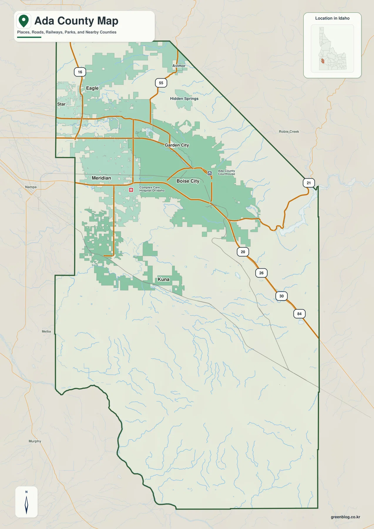
The same map also includes smaller place labels such as Avimor and Hidden Springs in the north and northeast. Those labels matter because they extend the picture beyond the Boise-Meridian core and show where developed areas approach the foothills. The county outline itself is distinctive: a broad northern block narrows and angles along the northeast, then extends far south toward the Snake River. Reading the road and settlement labels against that outline helps explain why the northern part feels urban and connected while the southern half appears more open.
Six major cities concentrated in the northern half
The city-distribution map strips away much of the extra detail and ranks six major cities: Boise City, Meridian, Eagle, Kuna, Star, and Garden City. Boise City and Meridian occupy the first two positions in the map’s index and sit close together near the center of the developed northern area. Eagle and Star are northwest of that pair, Garden City is tucked beside Boise near the river, and Kuna is the only ranked city shown well to the south. The layout makes one point especially clear: Ada County’s largest city labels are heavily concentrated in the northern portion of the county.
That concentration becomes more obvious because the long southern half has no ranked major-city marker at all. Instead, the background shows a more open road and drainage pattern. This makes the city map useful for quick orientation when a full road map contains more information than you need. If you are trying to compare Boise, Meridian, and Eagle, the numbered city markers are easy to scan; if you need to know which route connects them, you can then return to the boundary-and-road map for the larger transportation context.
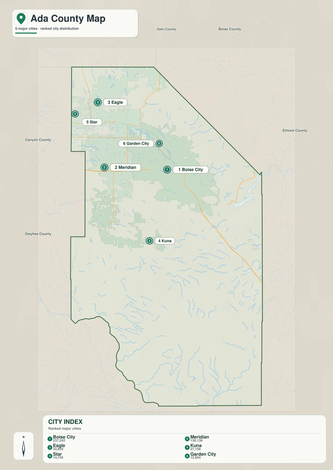
This map is best for relative position rather than travel measurement. It shows which cities sit near one another, but it does not provide road mileage or driving time. Boise City and Meridian are close in the central northern area; Eagle and Star sit northwest of them; Garden City is a small river-adjacent city beside Boise; and Kuna stands distinctly farther south. That simple arrangement is useful when you want a quick mental picture of the county before moving on to roads, waterways, or elevation.
The Boise River, Lucky Peak, and the long southern drainage network
The water-and-terrain map gives the eastern and southern parts of Ada County much more detail. Lucky Peak Lake is labeled on the eastern side where steep terrain closes in around the Boise River. From there the Boise River runs west toward the urban area. Near Boise, the map also labels Quinns Pond, Esther Simplot Pond 2, and Park Lagoon. Ridenbaugh Canal crosses the flatter central area, while Fivemile Creek and Lake Patricia appear farther south and southwest of the river corridor.
Farther from the city cluster, the map names Big Gulch Creek in the north, Blacks Creek Reservoir in the southeast-central area, and Indian Creek and Sand Creek across the southern interior. Corder Creek is marked near the southeastern edge. At the opposite corner, the Snake River follows the southwest boundary through a deeply cut landscape. The shaded terrain behind the water features is important because it shows the setting: tributaries in the northeast descend through rough foothills, while many southern streams cross broader and gentler terrain before reaching larger river systems.
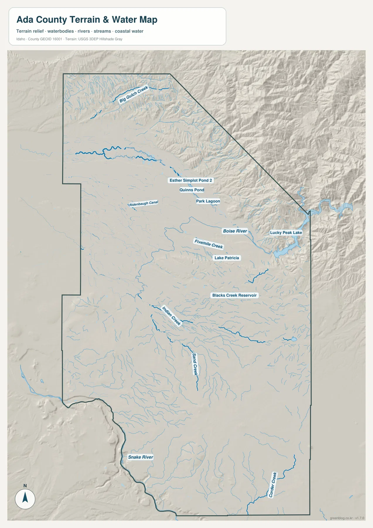
This is a reference map for locating water features, not a flood-zone, parcel, legal-boundary, or navigation map. Its strength is comparison. You can see the Boise River moving through the northern urban area, Lucky Peak tucked against the eastern foothills, and the Snake River far to the southwest. Smaller names such as Ridenbaugh Canal, Indian Creek, and Blacks Creek Reservoir add the detail needed to understand that the apparently open southern half of the county still contains a dense network of waterways.
Low valley ground beside steep northeastern relief
The elevation map turns the county’s shape into a simple height comparison. Its legend notes an actual elevation range of about 688 to 1,823 meters and a mean elevation of about 929 meters. Much of the Boise-Meridian area and the broad western and central ground appears in lower green tones. Moving northeast and east, the colors shift through lighter greens and yellows into brown as ridges and valleys become steeper. The transition is especially strong around the Lucky Peak side of the county.
The southern part is generally lower than the northeastern mountains, but it is not featureless. Small hills, shallow valleys, and isolated rises remain visible, while the southwest edge drops toward the Snake River. When the elevation view is compared with the city map, the relationship is easy to see: Boise, Meridian, Garden City, Eagle, and Star occupy the broad lower ground, while the eastern county boundary climbs into rugged terrain over a relatively short distance. Route 21 on the road map provides a useful reference for that change because it leaves the Boise area and heads toward Lucky Peak.
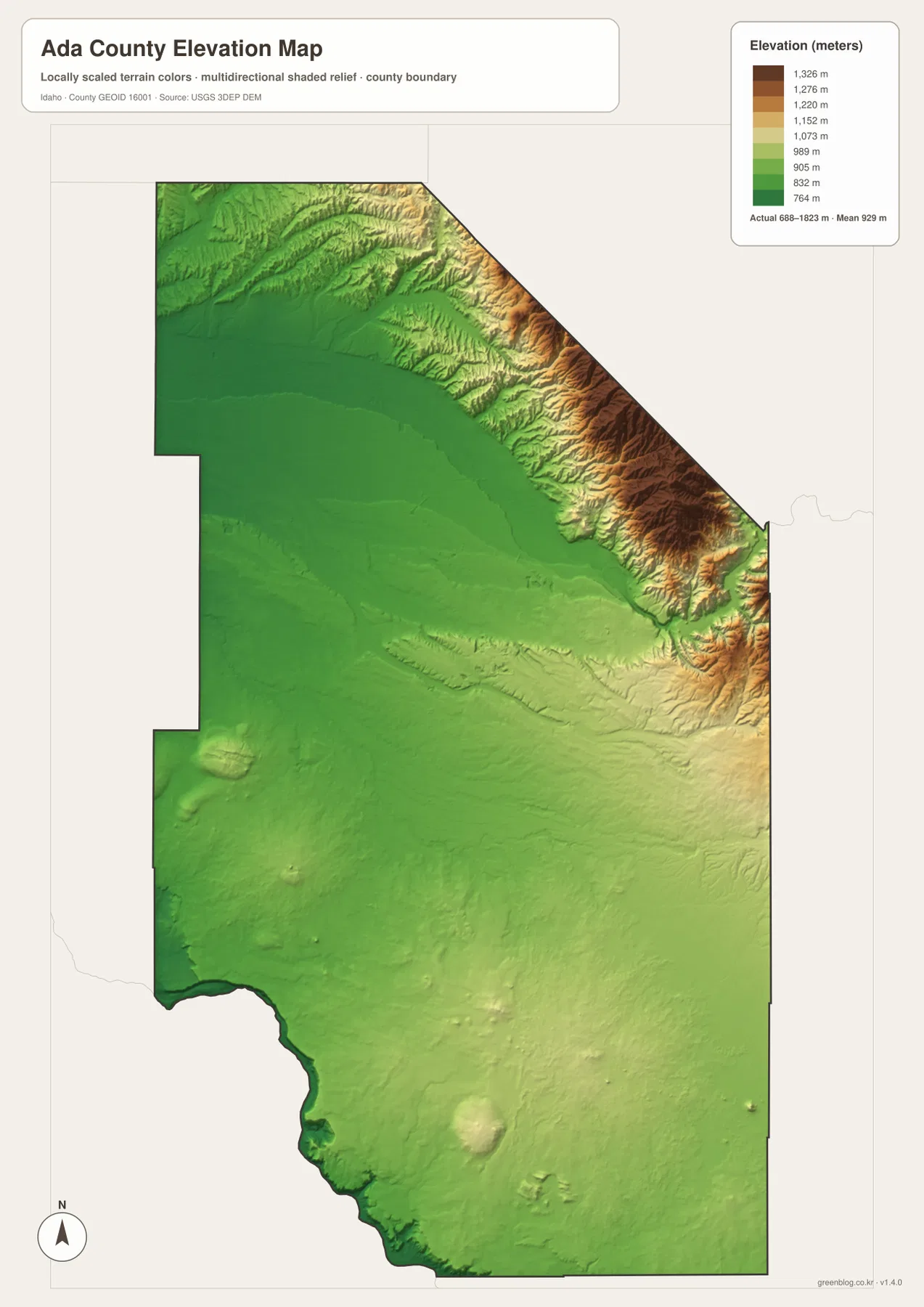
The elevation surface is intentionally generalized for county-wide comparison. It is useful for recognizing low valleys, rising foothills, and broad relief differences, but it should not be treated as survey-grade or engineering-grade elevation at a specific point. Projects that require precise site elevation should use authoritative source data or field survey measurements. For ordinary map reading, however, this view explains the county’s major terrain contrast much more clearly than a road map alone.
Choosing the clearest map for a Boise-area or county-wide question
If your goal is to locate Boise, Meridian, Kuna, the county boundary, and the principal numbered roads, start with the general county map. The city map is cleaner when the main question is simply where the six largest labeled cities sit in relation to one another. Water features such as Lucky Peak, the Boise River, the Snake River, canals, reservoirs, and named creeks are much easier to follow on the water-and-terrain map. The elevation view is the better choice when the subject is the contrast between the low urban valley and the much higher northeastern foothills.
For a class handout or regional overview, the boundary map gives the broadest single-page introduction. A presentation about the Boise metropolitan pattern may benefit from the city-distribution map because the main places are emphasized without extra labels. A report about rivers, reservoirs, or recreation can use the water map to establish location, while a terrain discussion should pair that map with the elevation view. Using the maps in this sequence also prevents one map from carrying too much information: location first, then city pattern, water system, and relief.
Frequently Asked Questions
Which map is best for finding Boise, Meridian, and the main roads?
Use the general boundary-and-road map first. It places Boise City and Meridian alongside Eagle, Star, Garden City, and Kuna, and it also shows the principal numbered routes such as 16, 55, 21, 20, 26, 30, and 84. If you only need a quick comparison of the six main cities and do not need the road detail, the city-distribution map is simpler.
Can I see the Boise River, Lucky Peak, and the Snake River on one map?
Yes. The water-and-terrain map shows Lucky Peak Lake and the Boise River in the east and north-central area, plus the Snake River along the southwest boundary. It also labels smaller features including Ridenbaugh Canal, Blacks Creek Reservoir, Indian Creek, Sand Creek, and Corder Creek. The map is intended for location reference rather than flood-risk or navigation decisions.
Should the elevation map be used as a precise survey surface?
No. The elevation map is designed to compare broad terrain across Ada County. It clearly shows the lower Boise-Meridian area and the much higher northeastern and eastern relief, but it does not replace site-specific survey data. Use official elevation datasets or a professional survey when exact point elevations are required.
Map File Information
The ZIP contains the original high-resolution JPG versions of the boundary-and-road map, city-distribution map, water-and-terrain map, and elevation map used on this page.
- Printable Size: 2572 × 3638 px each
Related Maps
Sources and references
These official resources provide additional county, boundary, water, and elevation information.
- Ada County Parks & Waterways – Boise River Greenbelt
- U.S. Census Bureau TIGER/Line Shapefiles
- USGS National Hydrography
- USGS 3D Elevation Program
Green Map creates custom-edited map images using open geographic data sources such as geoBoundaries, Natural Earth, OpenStreetMap, and government open data.
These maps are edited visual materials, not raw data files, and are provided for education, documents, presentations, and graphic reference.