The Seminole County Florida Map makes more sense once Lake Jesup is used as a central reference point. Sanford, the county seat, sits well to the north near Lake Monroe. Lake Mary, Longwood, Altamonte Springs, and Casselberry occupy the more developed western and southwestern side, while Winter Springs and Oviedo lie east of that corridor. Farther east, the labels change from closely spaced suburban cities to places such as Black Hammock, Geneva, and Chuluota, where waterways and larger open areas take up more of the map.
This page includes a county reference map for roads and place names, a simplified city map for comparing the main urban centers, and a terrain-and-water map that emphasizes lakes, rivers, and creeks. The same three map subjects are available below as high-resolution A3 JPG files in one ZIP download. Use the general map when you need local orientation, the city map when the relative placement of Sanford and the southern cities matters most, and the water map when Lake Jesup, Lake Monroe, Lake Harney, or the Wekiva and Econlockhatchee systems are the focus.
Table of Contents
Lake Jesup is the best reference point for the county layout
On the county map, Lake Jesup occupies a broad central position and separates several of the labels that otherwise look close together. Sanford is north of the lake and near the southern edge of Lake Monroe. Lake Mary and Heathrow are southwest of Sanford, followed farther south by Longwood, Altamonte Springs, and Casselberry. Forest City and Wekiwa Springs appear near the southwest side, close to the Orange County line. The result is a dense cluster of named places in the west and southwest rather than a single city center in the middle of the county.
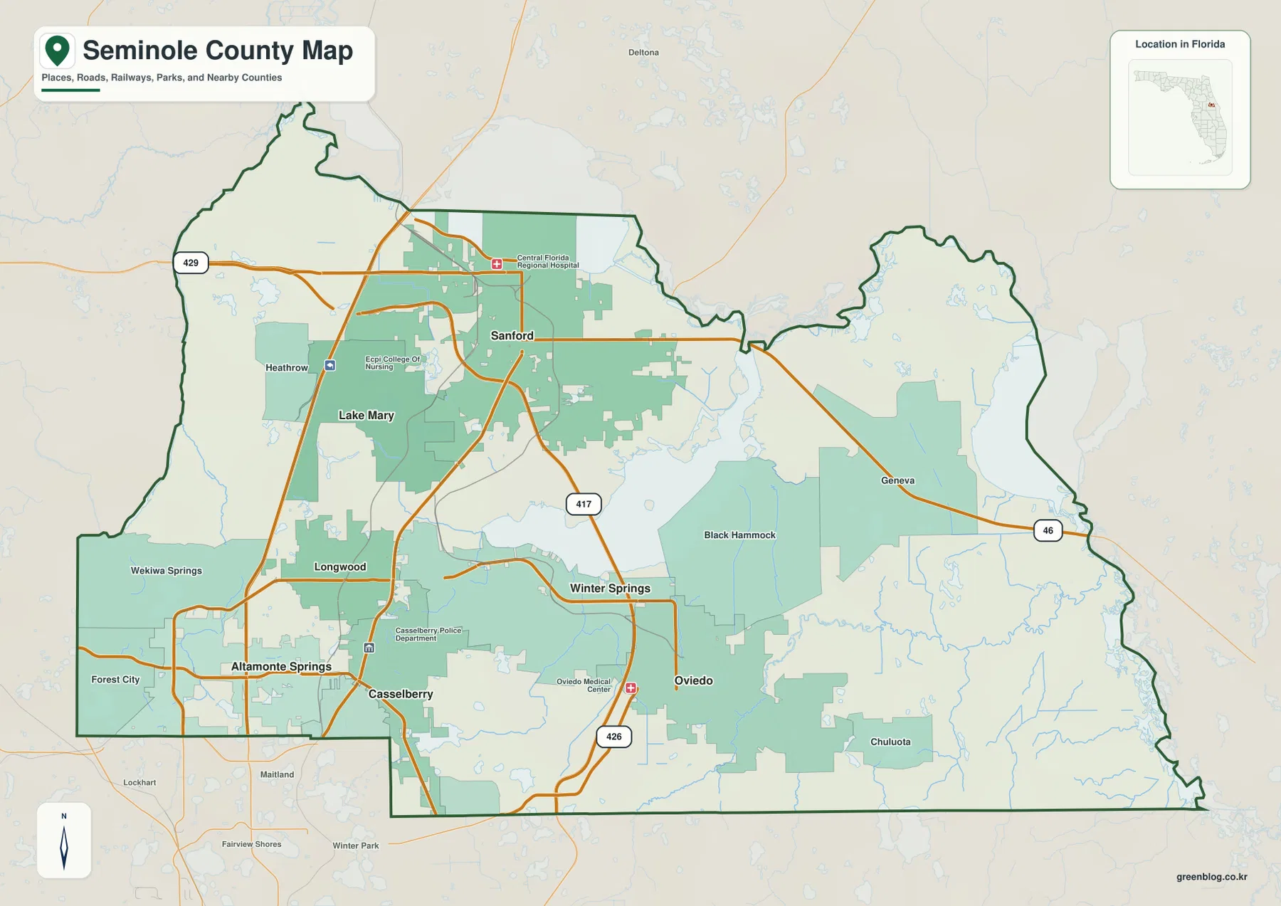
The county boundary is just as important as the place labels. Orange County is immediately south, Lake County is to the west, Volusia County borders much of the north and northeast, and a short southeastern edge meets Brevard County. Built-up areas around Altamonte Springs, Casselberry, and Oviedo continue toward northern Orange County, so the change from one county to another can be less obvious on a regional road map than it is on this boundary-focused view.
The source material for this package lists seven incorporated cities: Altamonte Springs, Casselberry, Lake Mary, Longwood, Oviedo, Sanford, and Winter Springs. The map also labels places such as Geneva, Chuluota, Black Hammock, Forest City, and Wekiwa Springs. Those names are useful for orientation, but a place label does not automatically mean that the place is one of the seven incorporated cities. That distinction matters when the map is used to describe an address, a local government area, or a destination near a city but outside its municipal boundary.
Sanford and the western cities form the clearest urban corridor
The west side can be read as a north-to-south sequence. Sanford is the northern anchor, Lake Mary lies southwest of it, and Longwood and Altamonte Springs continue toward the Orange County line. Casselberry sits farther inland on the southwest side. The supporting material identifies I-4 as a major corridor through this developed area, while U.S. 17-92 provides an older north-south connection through Sanford, Longwood, Casselberry, and the Fern Park area. These routes help explain why the west side looks more continuously urban than the eastern half of the county.
Other state routes provide the cross-county links. SR 417 bends around the south side of Lake Jesup and the Oviedo area before turning toward Sanford. SR 46 crosses the county through Sanford and continues toward Geneva in the east, while the reference map also marks routes 426 and 429. The map is not a turn-by-turn navigation product, but these numbered roads are useful anchors when comparing the western city belt with the less densely labeled eastern side.
The simplified city map removes most smaller labels and highlights six major cities: Sanford, Altamonte Springs, Oviedo, Winter Springs, Casselberry, and Lake Mary. Sanford is clearly separated to the north, Altamonte Springs and Casselberry group in the southwest, and Oviedo and Winter Springs form the eastern cluster. Lake Mary sits between Sanford and the southwestern cities. This stripped-down view is helpful when the full map feels busy because it shows the broad city pattern without asking the reader to trace every road or community label.
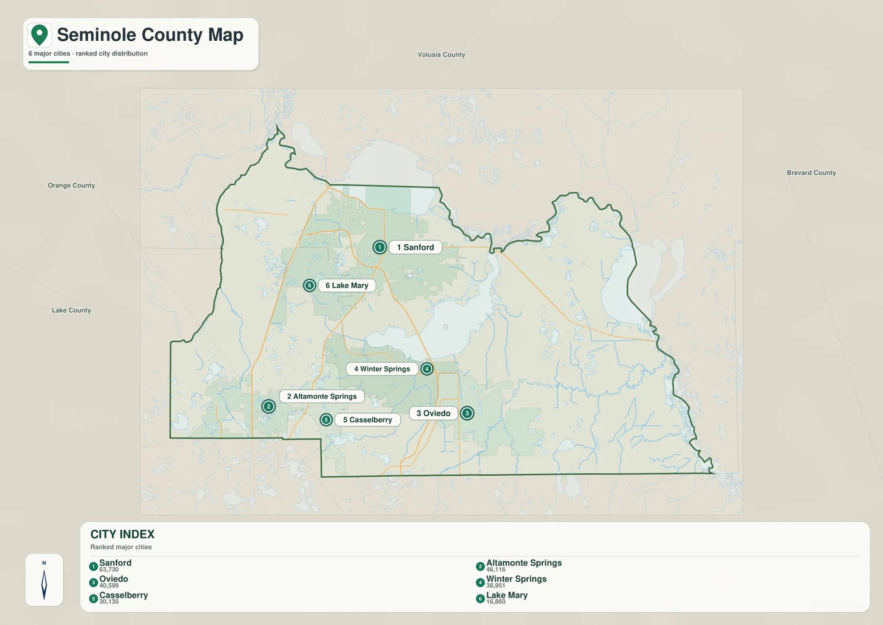
The package’s existing transportation material also describes four SunRail stations along the western side at Sanford, Lake Mary, Longwood, and Altamonte Springs. That sequence fits the city arrangement shown on the map and gives another reason the western side functions as a connected corridor. The map itself should not be used to confirm current train schedules or service status; it is better for understanding where those cities sit in relation to one another and to the county line.
East of Oviedo, suburban labels give way to waterways and open land
Oviedo is the most useful urban reference for the eastern half. Winter Springs lies to its west and northwest, Lake Jesup is immediately to the north, and Chuluota is southeast. Geneva is farther northeast, close to SR 46 and the river systems near the eastern county boundary. On the general map, roads and developed areas remain fairly dense around Oviedo, but that pattern becomes more open toward Geneva and Chuluota. The change is visible even without a land-cover layer because there are fewer urban labels and more creeks, wetlands, and broad green areas.
Black Hammock appears between Lake Jesup and the Geneva-Oviedo side, providing another useful label for the unincorporated east. These places are not interchangeable with the incorporated city names. For a reader trying to understand an address or a location description, the general county map is therefore more useful than the city-ranking map because it keeps the smaller communities visible while also showing the county boundary and the roads that connect them.
The source material gives Seminole County a land area of 309.38 square miles and Census FIPS code 12117. That is not a huge land area, yet the visual contrast across it is strong. The west and southwest contain the most continuous suburban development, while the eastern side has more water and unincorporated territory. Looking only at the county’s relationship to Orlando would miss much of this eastern landscape, especially around Geneva, Chuluota, the St. Johns system, and the Econlockhatchee River.
Lakes and rivers explain many of the county’s indirect routes
The terrain-and-water map changes the emphasis completely. Lake Monroe fills a large area along the north, Lake Jesup dominates the center, and Lake Harney sits on the eastern side. Little Wekiva River follows the western side, while the Econlockhatchee River is labeled in the southeast and east. The southern part of the map also marks Lake Howell, Howell Creek, and Bear Gully Creek. Smaller water bodies such as Seashell Lake and Lake Searcy add to the impression that the county is threaded with water even in the more urbanized half.
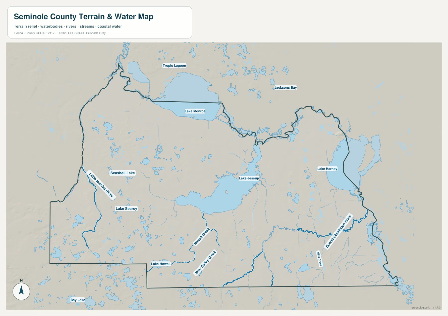
These lakes are more than decorative background. Lake Jesup occupies enough of the center that trips between places on opposite sides cannot follow the straight line suggested by their map distance. Lake Monroe and Lake Harney are part of the St. Johns River system along the north and east, and the Wekiva side creates another major watery edge in the west. Roads bend around open water, floodplain, and protected land, which is why two labels that seem close on the page may require a noticeably longer real-world route.
The existing source package also points to 2025 Florida Department of Environmental Protection planning for the Lake Jesup basin and for the Wekiva River, Rock Springs Run, and Little Wekiva Canal system. Those references reinforce the importance of the water network, but this page is still a general map guide rather than a flood, water-quality, or property-boundary product. Use the water map to understand where the named lakes and streams are, then consult the responsible agency’s current material for regulatory or environmental decisions.
Choose the map according to the question you are trying to answer
For a first look at Seminole County, start with the general map and locate Sanford and Lake Jesup. From there, trace Lake Mary, Longwood, and Altamonte Springs down the western side, then compare that line with Winter Springs and Oviedo to the east. If you need Geneva, Chuluota, Black Hammock, Forest City, Wekiwa Springs, or the numbered state routes, stay with the county map because those smaller labels are intentionally omitted from the simplified city view.
Use the city map when the main question is simply where the principal cities sit. It quickly shows Sanford at the north, Altamonte Springs and Casselberry in the southwest, and Oviedo and Winter Springs in the east. Use the water map when the question changes to why routes curve, where Lake Jesup sits relative to the cities, or how Lake Monroe, Lake Harney, Little Wekiva River, and the Econlockhatchee River relate to the county boundary. Switching between the general and water maps is especially useful because roads that look indirect often make more sense once the open water is visible.
The A3 JPG files in the ZIP are better suited to printing or inserting into documents than the smaller WebP images used in the article. The county map works well as the broad reference sheet, the city map is the cleanest choice for a quick city-location comparison, and the water map is best when lakes, rivers, and creeks are the subject. They cover the same county but are designed to answer different practical questions rather than repeat the same view three times.
Frequently Asked Questions
Why is Sanford so far north of the visual center of Seminole County?
Sanford developed on the south shore of Lake Monroe near the St. Johns River system and became the county seat when Seminole County was established in 1913, according to the material included with this package. Later suburban growth spread much farther south and west, but the county seat remained in Sanford. On the map, look for Lake Monroe rather than Lake Jesup when locating the county seat.
Why are Geneva and Chuluota labeled even though they are not in the seven-city list?
They are important community names in eastern Seminole County, but the county government’s incorporated-city list contains Altamonte Springs, Casselberry, Lake Mary, Longwood, Oviedo, Sanford, and Winter Springs. Geneva and Chuluota help readers orient themselves in the large unincorporated eastern area, so their labels are useful even though they do not represent separate incorporated cities.
Does Lake Jesup affect how close places are by road?
Yes. Lake Jesup occupies a broad central area, and roads must follow available crossings and routes around open water, wetlands, and protected land. Places on opposite sides may look close in a straight line but require a longer road trip. This map is intended for geographic orientation, so use current navigation information for exact driving distance and travel time.
Map File Information
Download the Seminole County reference map, city map, and water map as high-resolution A3 JPG files in one ZIP archive.
- Included Versions: County map, city map, water map
- Included Files: 3 high-resolution A3 JPG maps
Related Maps
- Arcadia Roads and Peace River | DeSoto County Florida Map
- Baker County Florida Map
- Between the Aucilla and Withlacoochee: Madison County Florida Map
Sources and Further Reference
County background, incorporated cities, and area information can be checked through Seminole County Government’s history and county profile and the U.S. Census Bureau QuickFacts page for Seminole County. For parks and natural lands, see the county’s parks, trails, and natural lands material. The package also references the Seminole County 2045 Transportation Mobility Plan for transit context and the Florida Department of Environmental Protection basin-management documents for Lake Jesup and Wekiva-related watershed planning.
Green Map creates custom-edited map images using open geographic data sources such as geoBoundaries, Natural Earth, OpenStreetMap, and government open data.
These maps are edited visual materials, not raw data files, and are provided for education, documents, presentations, and graphic reference.