You can download the Monroe County Tennessee Map files on this page as a ZIP of high-resolution JPGs for A3 printing. The page also provides four separate WebP previews: a county reference map with roads and places, a city-connection map centered on Sweetwater, a water-and-terrain map with named lakes and streams, and an elevation map that makes the county’s sharp west-to-east rise easy to see.
Monroe County is especially useful for map comparison because its western communities and eastern mountain country look very different on the same county outline. Sweetwater and Madisonville sit in the lower, gentler part of the county, while Tellico Plains opens toward much higher terrain in the east and southeast. The elevation sheet spans roughly 246 to 1,659 meters, with a mean near 439 meters. Tellico Lake occupies a broad northeastern water corridor, while Tellico River, North River, Citico Creek, and many smaller streams cut through the mountain side of the county.
Table of Contents
Roads and settlements from Sweetwater to the mountain side
The county reference map gives the clearest overview of settlement and road orientation. Sweetwater is near the northwestern edge, Madisonville sits farther south near the middle of the developed western half, and Vonore lies northeast beside the Tellico Lake system. Tellico Plains is well to the southeast, where the road network begins to meet more pronounced mountain relief. Coker Creek appears farther south and reinforces how far the county extends beyond the Madisonville–Sweetwater corridor.
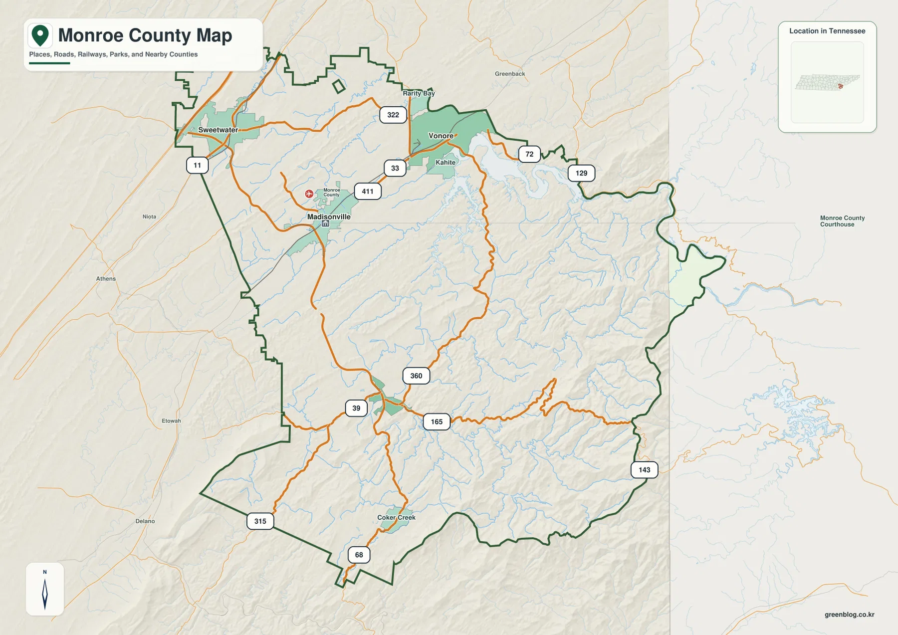
The route labels help separate those parts of the county without turning the page into a road atlas. US 11 is visible near Sweetwater, US 411 passes through the Madisonville corridor, and SR 33 and 72 serve the Vonore side. Farther south, SR 360 and 39 connect into the Tellico Plains area, while SR 68 and 315 appear near the southern side. SR 165 and 143 are particularly useful on the eastern half because they cross or follow terrain that is much steeper than the country around Sweetwater.
Nearby county labels provide another layer of orientation. McMinn and Polk counties are to the west and southwest, Loudon County is north, and Blount County is east of the northern mountain side. The eastern boundary also reaches the North Carolina mountain region. Because some towns, reservoirs, roads, and watersheds continue across county lines, the thick county outline should be checked before assigning an edge feature to Monroe County. This map is intended for county-scale reference rather than live navigation or road-condition decisions.
Sweetwater as the hub for Madisonville, Vonore, and Tellico Plains
The city-connection sheet removes much of the road detail and emphasizes four ranked places. Its index shows Sweetwater at 6,532, Madisonville at 5,241, Vonore at 2,191, and Tellico Plains at 1,146. Sweetwater is marked as the hub. The connectors are explicitly straight-line distances rather than driving distances: Madisonville is shown about 8 miles from Sweetwater, Vonore about 13 miles, and Tellico Plains about 18 miles.
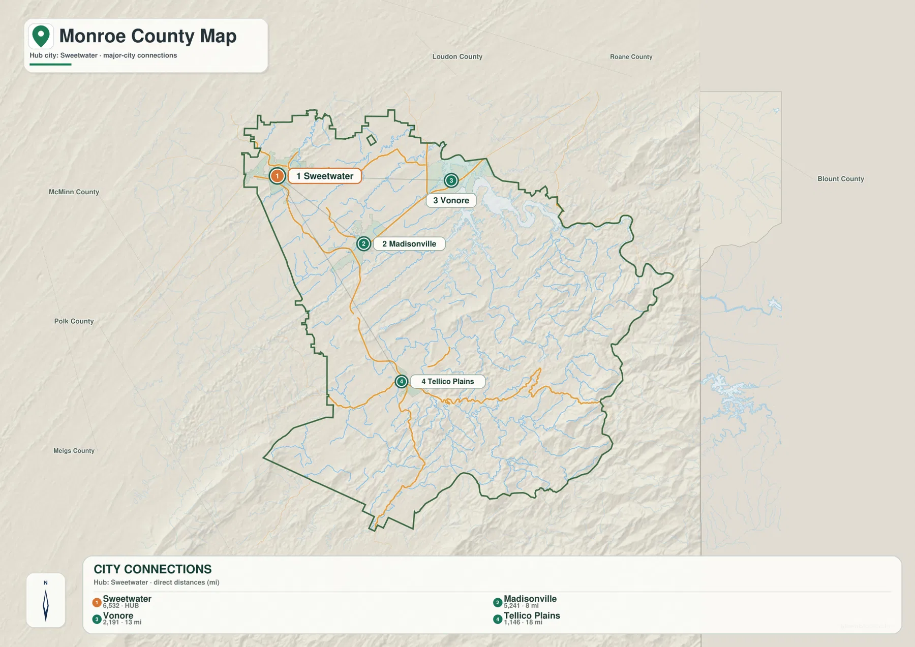
The positions matter as much as the numbers. Sweetwater and Madisonville are relatively close in the lower western part of the county, but Vonore shifts the comparison toward Tellico Lake. Tellico Plains sits in a different direction altogether, at the foot of the higher southeastern terrain. A short connector on this graphic should therefore not be read as a promise of equally short travel by road. Water crossings, valleys, and ridge patterns can make the practical route longer than the straight-line measurement.
For a presentation, the four places also work as four distinct geographic anchors rather than a list of city names. Sweetwater represents the northwestern urban edge, Madisonville the county-seat area, Vonore the lake corridor, and Tellico Plains the transition into the mountains. Returning to the county reference map after this simplified view makes the route network easier to explain because each road can be tied to a known destination.
Tellico Lake, mountain streams, and the southern river network
The water map is dominated by Tellico Lake in the northeast, where long arms of water extend into the county. Fork Creek and Bat Creek are labeled to the north and northwest of the lake, while Sweetwater Creek is farther west. Near the Madisonville side, the map also identifies smaller waters such as Kinser Pond, City Lake, and Carson Pond. These names provide finer reference points than the general county map and help connect towns and roads to their surrounding drainage.
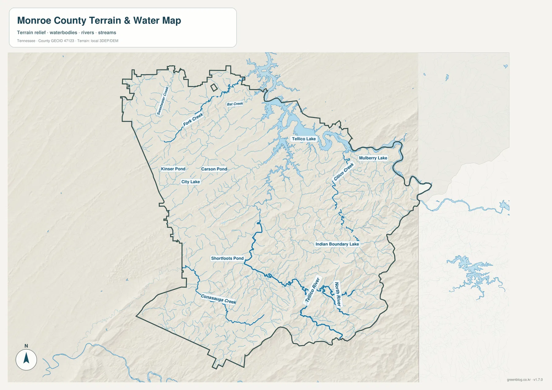
On the eastern mountain side, the drainage becomes much more intricate. Citico Creek runs through the northeastern highlands, Mulberry Lake appears near the eastern edge, and Indian Boundary Lake is labeled farther south. The southern half contains strong linear waterways as well: Tellico River crosses the mountain country, North River joins the same general drainage area, and Conasauga Creek reaches the southwestern side. Shortfoots Pond is another useful reference in that southern network.
This is a location-reference map for named water features, not a flood map or a navigation chart. It does not establish current water level, channel depth, boat access, parcel ownership, or legal shoreline limits. Its value is in showing which creeks and lakes sit between communities and roads, and in making the close relationship between mountain valleys and drainage visible before a reader consults a more specialized source.
A 246–1,659 m rise from the western lowlands to the eastern mountains
The elevation map shows an actual range of about 246 to 1,659 meters and a mean elevation near 439 meters. Much of the western side is rendered in the lower green classes, with long low ridges running through Sweetwater and Madisonville country. Moving east, the relief becomes progressively sharper. The strongest brown and tan classes cluster along the east and southeast, where closely spaced ridges and valleys form a distinctly mountainous landscape.
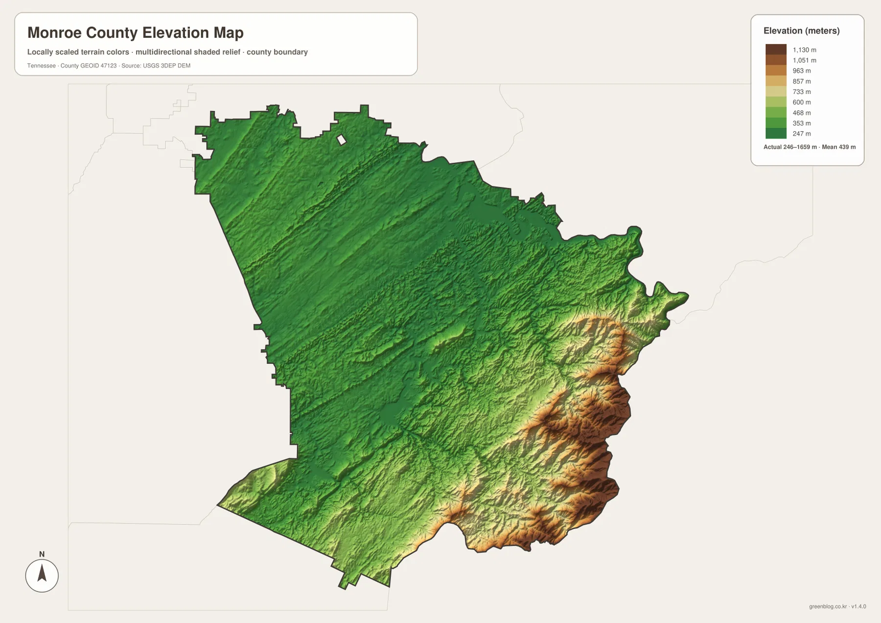
The terrain sheet also explains several relationships visible on the other maps. Sweetwater and Madisonville occupy the lower side of the county, while Tellico Plains sits near the point where the ground rises much more quickly. Tellico River, North River, and Citico Creek follow valleys cut into the higher country. Tellico Lake occupies a broad transition zone north of that mountain belt, where water, road corridors, and settlement all meet the changing relief.
The shaded elevation surface is appropriate for comparing countywide relief, but it is not a survey or engineering product. The legend’s high and low values describe the mapped elevation range, not the elevation of every property. For classroom, editorial, or planning illustrations, it works best when paired with the road and water maps so that a reader can see why travel corridors and streams follow particular gaps and valleys.
Population, area, and the county-scale picture
The supplied county material lists a 2020 census population of 46,250 and a July 2025 estimate of 49,730. It also gives a Gazetteer land area of about 635.8 square miles and water area of about 16.8 square miles, with FIPS code 47123. Those county totals should be kept separate from the city figures printed on the connection map. They describe the jurisdiction as a whole rather than the footprint or population of any single community.
| Reference | Value in the supplied material |
|---|---|
| County seat | Madisonville |
| 2020 census population | 46,250 |
| July 2025 population estimate | 49,730 |
| Land area | about 635.8 sq mi |
| Water area | about 16.8 sq mi |
| Elevation-map range | about 246–1,659 m; mean about 439 m |
Madisonville is the county seat, while Sweetwater is the hub used by the supplied city-connection graphic. These labels serve different purposes. One identifies the administrative center; the other provides a convenient starting point for comparing the four mapped cities. Keeping those roles separate prevents the map from implying that the hub designation changes the location of county government.
Choosing the right Monroe County map and downloading the JPG set
Use the county reference map when you need roads, communities, neighboring areas, and the boundary in one view. Choose the city-connection map when the main question is where Sweetwater, Madisonville, Vonore, and Tellico Plains sit relative to one another; remember that its connector values are straight-line distances. The water sheet is the better choice for Tellico Lake, Citico Creek, Tellico River, North River, and smaller named waters. For the dramatic contrast between the western lowlands and the eastern mountains, the elevation map is the clearest of the four.
The download below packages the matching high-resolution JPG maps for printing or reuse. A practical workflow is to keep the county reference map as the broad locator, add the city sheet when discussing settlement, and pair the water and elevation maps when explaining the Tellico side of the county. Because each file has a different emphasis, readers can use only the layers that fit a lesson, report, presentation, or regional comparison.
Frequently Asked Questions
Are the 8, 13, and 18 mile city connectors driving distances?
No. The city-connection sheet labels them as straight-line distances from the Sweetwater hub. Madisonville is shown about 8 miles away, Vonore about 13 miles, and Tellico Plains about 18 miles. Actual road travel can be longer because routes follow valleys, cross water at limited points, and curve around higher terrain.
Can I find both Tellico Lake and Tellico River on the water map?
Yes. Tellico Lake is the large northeastern water body, while Tellico River is labeled farther south in the mountain drainage. The same sheet also identifies Citico Creek, North River, Conasauga Creek, Indian Boundary Lake, Mulberry Lake, and several smaller ponds and creeks.
Where is the largest elevation change in Monroe County?
The elevation map shows the lower classes across much of the west and northwest, then a strong rise toward the east and southeast. The highest terrain is concentrated along the mountain side of the county, while Sweetwater and Madisonville lie in much lower country. The 246–1,659 m legend is useful for countywide comparison but should not be treated as parcel-level survey data.
Map File Information
The ZIP contains the Monroe County reference map, city-connection map, water map, and elevation map as high-resolution JPG files for A3 use.
- Included Files: county map, city-connection map, water map, elevation map
- File Type: JPG
Related Maps
Sources and references
- Tennessee State Library and Archives Monroe County fact sheet
- Tennessee Department of Transportation Monroe County road reference
- U.S. Census Bureau Monroe County QuickFacts
- U.S. Census Bureau TIGER/Line boundary data
- USGS National Hydrography
- USGS 3D Elevation Program
Green Map creates custom-edited map images using open geographic data sources such as geoBoundaries, Natural Earth, OpenStreetMap, and government open data. These maps are edited visual materials, not raw data files, and are provided for education, documents, presentations, and graphic reference.