You can download the Hendry County map files on this page as a single ZIP of high-resolution A3 JPGs. Before choosing a map, it helps to see the county as two very different ends of one broad east–west corridor. LaBelle, the county seat, sits in the west where State Roads 29 and 80 meet the Caloosahatchee River, while Clewiston anchors the east on the U.S. 27–SR 80 corridor near the southwestern edge of Lake Okeechobee. Between them are farms, rural subdivisions, wetlands, and an extensive network of managed canals, so a short straight-line gap on a county overview can turn into a much longer trip when a bridge or public road is not available.
A practical first step is to treat SR 80 as the main horizontal reference. From LaBelle it runs east past the Port LaBelle and Pioneer area toward Clewiston, while SR 29 leaves LaBelle to the south toward Felda and the wetland landscapes closer to Collier County. Harlem lies immediately south of Clewiston, and Montura is farther southwest in the interior. Those names do not all represent incorporated cities, and their roads are not built on one continuous urban grid. Pair a place name with the nearest trunk road and with the nearest river or canal crossing before using it as a travel reference.
The supplied archive contains a county map, a city-distribution map, and a terrain-and-water map. The county map is the best starting point for roads, communities, and the county outline. The city map strips away most secondary detail so the west–east separation of LaBelle and Clewiston is immediately visible. The water map shifts attention to the Caloosahatchee, sloughs, drainage canals, and lake-edge water features. These are orientation maps rather than parcel, flood, navigation, or engineering products, so decisions about access, property limits, dike use, or water conditions require current official data.
Table of Contents
Start with SR 80, then separate the LaBelle and Clewiston sides of the county
The county map is organized around a strong west–east contrast. LaBelle appears on the western side where SR 80 crosses SR 29 and the Caloosahatchee River. Fort Denaud is shown west of LaBelle along the river, while Port LaBelle occupies a broad area to the east. The similarity of those two names can be misleading in a search or spoken directions: Fort Denaud and Port LaBelle are on opposite sides of the county seat. A useful location note therefore includes both the community name and whether the destination is east or west of LaBelle and north or south of the river.
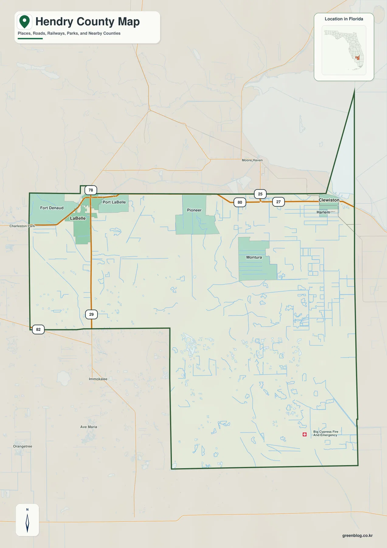
Clewiston is a different kind of reference point. U.S. 27 and SR 80 run through the eastern city, Harlem is directly to the south, and Lake Okeechobee lies at the city’s northern and eastern edge. The nearby Herbert Hoover Dike, rim canal, agricultural canals, and access roads create several parallel lines that do not serve the same purpose. A road map may make them look close together, but a traveler must still determine which line is a public road, which is a water-control feature, and where a legal crossing or entrance actually exists.
The broad middle of the county is not a continuous suburban strip between the two cities. Pioneer is shown south of the SR 80 corridor in the interior, and Montura sits farther southeast and southwest of Clewiston. Large agricultural blocks and canal systems fill much of the space around them. For a rural destination, use the county overview to choose the correct side of Hendry County, then move to a current road or parcel source to confirm the final approach rather than assuming the nearest visible grid line is drivable.
The surrounding geography also helps with orientation. The supplied article materials identify Glades County to the north, Palm Beach County to the east, Broward County to the southeast, Collier County to the south, and Lee County to the west. Moore Haven appears north of the county in the map background, while Immokalee is visible to the southwest. These outside labels are useful for direction, but a small overview can simplify water boundaries and corner contacts. Legal boundary work should use the county’s current GIS or Census boundary data instead of the visual edge of the illustration.
The city map explains why Hendry has two centers instead of one urban core
The city-distribution map reduces the county to its two incorporated municipalities. Clewiston is ranked first in the city index and LaBelle second, with the markers placed near opposite ends of Hendry County. The large empty-looking space between them is important: the map is not missing a continuous chain of cities. Much of the county is rural, agricultural, wetland, reservation, or water-management land, and that land is served by different road and canal systems rather than by one metropolitan street network.
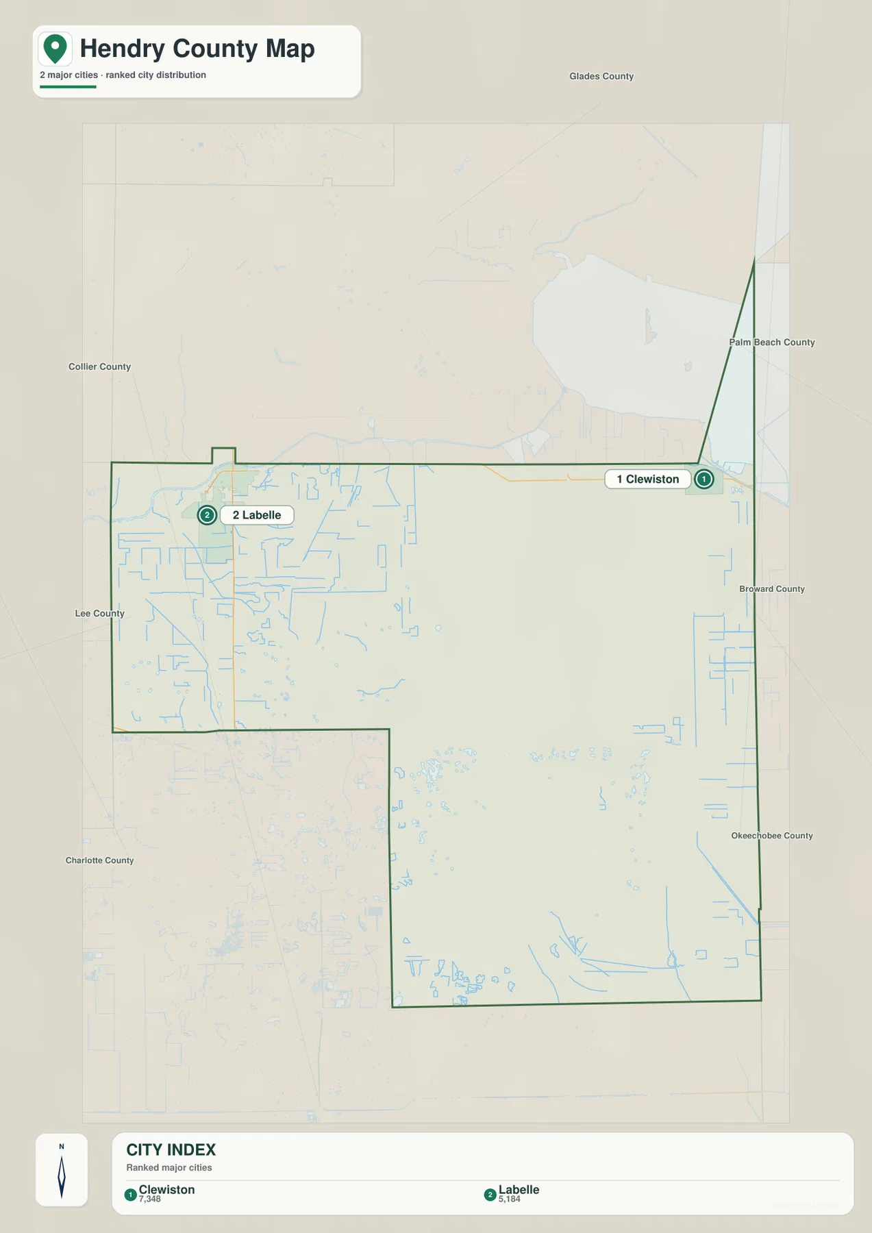
LaBelle is the more useful anchor for county government, the Caloosahatchee crossing, Fort Denaud, Port LaBelle, and the SR 29 route south toward Felda. Clewiston is the better anchor for Harlem, the Lake Okeechobee edge, U.S. 27, and the dense agricultural canal grid in the east. That difference matters when a mailing address uses LaBelle or Clewiston even though the property may be outside the incorporated city limit. A city name on an address does not by itself establish municipal jurisdiction, zoning, tax district, or emergency-service boundary.
Smaller communities should be located with the full county map rather than the city index. Port LaBelle, Fort Denaud, Pioneer, Montura, Harlem, and Felda each occupy a different relationship to SR 80, SR 29, the river, or the canal network. In the rural south, a regular grid can suggest urban blocks even when the roads are widely spaced, unpaved, interrupted, or separated by drainage channels. The city map is therefore best for explaining the county’s two main centers, while the detailed approach to a rural property belongs in a different map layer.
This two-center structure also helps explain why the same driving strategy does not work everywhere. Around LaBelle, the first question is often which side of the Caloosahatchee a destination occupies and which bridge connects it. Around Clewiston, the first question may be whether the destination lies north or south of the U.S. 27–SR 80 line and how the route interacts with the dike or agricultural canals. Recording those local reference points is more useful than describing every Hendry County trip as a simple east–west movement.
River in the west, lake edge in the east, and canals across the interior
Water is the element that most changes how Hendry County roads should be read. The Caloosahatchee River crosses the western side at LaBelle, dividing local streets and making bridge locations important. Farther east, long straight drainage and agricultural canals become much more prominent. Near Clewiston, the county meets the Lake Okeechobee system, where the dike, rim canal, water-control structures, and farm drainage network occupy a small geographic area. The blue lines on a map therefore represent several different kinds of water features rather than one continuous natural stream network.
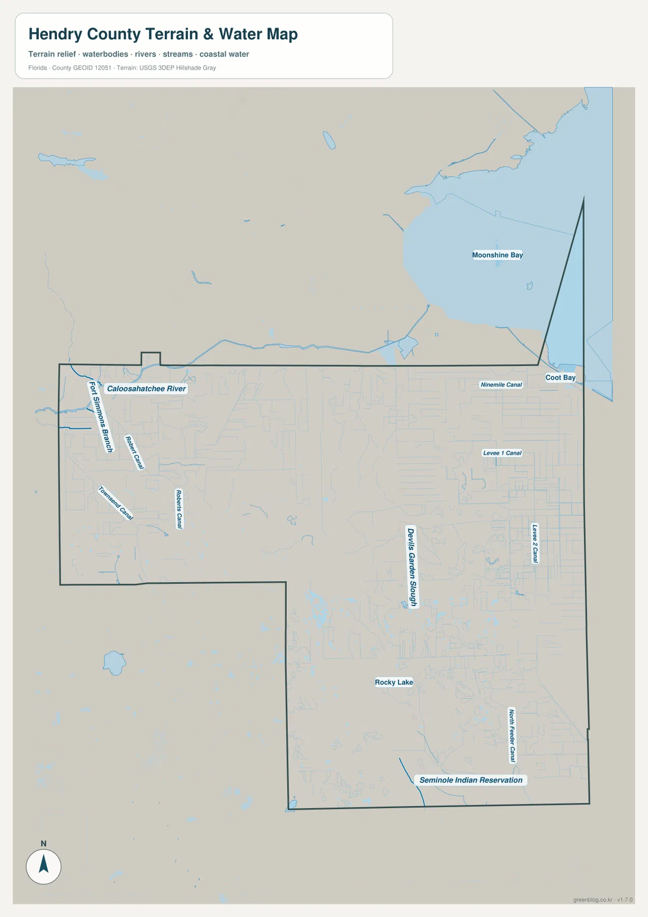
On the western side, the map labels the Caloosahatchee River and Fort Simmons Branch, with Roberts Canal and Townsend Canal nearby. Their geometry immediately shows why a rural location can be close across water but far by road. Roads often run beside a canal, and a canal can resemble a road at a small scale. Before planning a route, trace the line to a known bridge or trunk road and confirm the symbol in a more detailed source. The county overview is excellent for recognizing the pattern but not for proving that a crossing exists.
The central and eastern parts of the water map include Devil’s Garden Slough, Nine Mile Canal, Levee 1 Canal, and Levee 2 Canal. A slough is a low, wet drainage feature, while the long straight canals are managed water-control features. Their appearance can overlap on a simplified map even though their origins, maintenance, and access conditions differ. This is especially important in agricultural country, where drainage structures may run beside fields and private roads that are not public travel routes.
Rocky Lake appears in the southern interior, while North Feeder Canal and the Seminole Indian Reservation label help orient the southeastern part of the map. The reservation is not simply another unincorporated subdivision, and a line entering tribal land should not be treated as automatic public access. The same caution applies to canals and levees: a visible line can be a useful geographic reference without being open for travel or recreation. Current rules come from the managing authority, not from the overview map.
Near the northeastern edge, labels such as Moonshine Bay and Coot Bay appear around the Lake Okeechobee side of the map. They help place Clewiston in relation to the larger lake system, but they should not be used as precise county-boundary geometry. Lake, dike, rim-canal, and administrative lines can be drawn differently depending on the data source and purpose. When the exact boundary across water matters, use the official county or Census layer rather than the edge of this reference image.
The contrast between LaBelle and Clewiston is especially clear when the road and water maps are viewed together. LaBelle is a river city where the Caloosahatchee crossing shapes local access. Clewiston is a lake-edge city where dikes and managed canals are part of the surrounding transportation and agricultural landscape. A concise but useful field note for LaBelle might record the side of the river and bridge; a note for Clewiston should distinguish the highway, the dike side, and the canal or grid in which the destination lies.
South of the main corridor, read the road grid together with wetlands and managed land
Felda is the strongest place-name reference on the SR 29 route south of LaBelle. It helps separate travel toward Collier County and the Okaloacoochee Slough landscape from the eastbound SR 80 route to Clewiston. County Road 832 is a useful access reference in the state-forest area, but the existence of a county road does not mean every forest track connected to it is open at all times. Wet conditions and land-management activity can change internal access, so the Florida Forest Service remains the source for current openings and rules.
Montura and Pioneer represent a different kind of rural landscape. Their grid patterns are visually regular, but they are not equivalent to dense city blocks. Roads, drainage ditches, private property lines, and canals can repeat at similar spacing. A parcel may be only a short distance from a trunk route in a straight line and still require a longer approach because the nearest canal has no crossing. A good workflow is to identify the rural community, trace the grid to SR 80 or another recognized road, and then verify the final segment in county GIS or an up-to-date road source.
The eastern agricultural area requires the same discipline. Clewiston and Harlem are close together, but much of the land immediately south and west of the city is organized for farming and water management rather than urban circulation. A long straight line can be a farm road, drainage canal, levee, or boundary. That is why the overview should not be used to decide whether a road is public, whether a gate can be passed, or whether a particular field can be reached from the nearest visible line.
Two large managed landscapes add another layer of complexity. The supplied material describes Okaloacoochee Slough State Forest as a large conservation area spanning Hendry and Collier counties, while the Big Cypress Seminole Indian Reservation forms a prominent land unit in southeastern Hendry. Neither should be treated like an ordinary residential road grid. Forest-road conditions depend on state management, and access to tribal lands and facilities is governed by the Seminole Tribe and the specific site involved.
For rural directions, the most useful description is usually a combination of road, community, and water or land-management feature. “South on SR 29 toward Felda and CR 832” is more informative than a distance from LaBelle alone. “Southwest of Clewiston in the Montura grid, west of the main canal” is more informative than saying a location is simply near Clewiston. Hendry County is a place where connections matter more than visual proximity.
Managed water projects can make recent imagery look different from older Hendry County maps
Hendry County contains major water-management infrastructure that can change the appearance of aerial imagery over a short period. The retained article material identifies the Caloosahatchee C-43 Reservoir west of LaBelle and south of SR 80 as a project that officially opened in July 2025. It is described as a roughly 10,000-acre Everglades-restoration facility designed to store wet-season water and support dry-season freshwater flow. It should be understood as engineered water infrastructure, not as a naturally formed public lake.
Construction-stage images of the C-43 site can look very different from operating-stage images. Earlier views may show dry cells, earthwork, and perimeter embankments, while later views can show broad water surfaces that vary with operating level. Anyone comparing map editions or historical aerials should record the imagery date before treating the difference as a natural change in the landscape. The straight embankments and canals are a clue that the feature is managed infrastructure.
The Herbert Hoover Dike around Lake Okeechobee is another line that should not be confused with an ordinary roadway. The supplied materials note the U.S. Army Corps of Engineers announcement of substantial completion of a major rehabilitation effort in 2023. Dike roads, rim canals, water-control structures, and public highways have different functions and access conditions. Near Clewiston, those elements are close enough that a simplified map can make them seem interchangeable unless the user checks labels and current access information.
Agriculture also shapes the map. The source material describes Hendry as one of Florida’s leading agricultural counties, with sugarcane, citrus, pasture, cattle, and related operations contributing to large blocks of managed land. Those uses help explain the regular eastern canal grid and the scale of fields and service roads. A line that exists to drain a field or move farm equipment should not be assumed to function as a public through road.
The county’s history gives context to the present pattern. The retained article states that Hendry County was created from eastern Lee County in 1923, with LaBelle selected as the county seat and the county named for Captain Francis Asbury Hendry. Today the western river-centered settlement around LaBelle and the eastern lake-and-agriculture center around Clewiston still feel distinct. The map is easier to understand when those environments are treated as complementary parts of one county rather than as a single uniform landscape.
Choose the map by task, then use the A3 JPG archive for print or study
Use the county overview when the question is “where is this place in Hendry County?” It combines LaBelle, Clewiston, Fort Denaud, Port LaBelle, Pioneer, Montura, Harlem, major roads, and the county outline in one view. It is the most useful page for deciding which side of the county to investigate next and for explaining how SR 80, SR 29, and U.S. 27 relate to the main communities.
Use the city-distribution map when the message needs to be simpler. It makes the separation of LaBelle and Clewiston obvious and removes much of the secondary road and water detail. That makes it suitable for a presentation, lesson, or quick county orientation. It is not sufficient for a rural address because communities such as Montura, Pioneer, Fort Denaud, and Port LaBelle depend on smaller-road and canal context that the city map intentionally leaves out.
Use the terrain-and-water map when the main question is how rivers, sloughs, canals, and the lake-edge system affect the county. It is particularly useful for showing the Caloosahatchee in the west and the increase in managed water features toward the east and south. It does not show current flood risk, water level, legal water access, or navigation conditions, so those topics belong to the responsible water-management and emergency agencies.
The downloadable archive contains the original A3 JPG counterparts of the three body maps. The archive name is hendry_county_florida_3_map_jpg.zip. The larger JPG files are better suited to printing, classroom handouts, presentations, or personal regional notes than the smaller WebP images used in the article. For any decision that depends on changing conditions—road closures, parcel boundaries, flood status, dike access, forest-road openings, or tribal-site access—pair the downloaded map with the current official source.
Frequently Asked Questions
Do LaBelle and Clewiston form one continuous urban corridor along SR 80?
No. SR 80 connects the two cities, but broad rural and agricultural land lies between their developed areas. LaBelle is the western county-seat and river reference, while Clewiston is the eastern reference near Lake Okeechobee and the agricultural canal network. For an address between them, identify the nearest community and the road or canal crossing rather than assuming continuous city streets.
Are the straight grid lines south and west of Clewiston all public roads?
No. In eastern and southern Hendry County, roads, agricultural drainage canals, levees, and property lines can all appear as long straight features. A county overview cannot establish public access or show every usable bridge. Confirm the symbol and trace the connection in current Hendry County GIS or road data before relying on a line as a through route.
Can the terrain-and-water map be used to determine flood risk or dike access?
No. It is an orientation map showing the location of the Caloosahatchee River, named canals, sloughs, lake-edge water features, and managed land. Flood zones, current water levels, dike closures, navigation rules, and public access can change and require current information from Hendry County, the South Florida Water Management District, the U.S. Army Corps of Engineers, or another responsible agency.
Map File Information
This ZIP contains the Hendry County overview, city-distribution map, and terrain-and-water map as high-resolution A3 JPG files.
- Included Files: 3 A3 JPG maps
Related Maps
- Arcadia Roads and Peace River | DeSoto County Florida Map
- Baker County Florida Map
- Blountstown, SR 20, and the Apalachicola River | Calhoun County Florida Map
Sources
- Official Hendry County website
- Florida Department of Transportation county general highway maps
- South Florida Water Management District C-43 reservoir information
- Florida Forest Service Okaloacoochee Slough State Forest
- Seminole Tribe of Florida Big Cypress Reservation
- U.S. Census Bureau Hendry County QuickFacts
Green Map creates custom-edited map images using open geographic data sources such as geoBoundaries, Natural Earth, OpenStreetMap, and government open data. These maps are edited visual materials, not raw data files, and are provided for education, documents, presentations, and graphic reference.